Cold spell occuring from July 13 2014 to July 16 2014 at 44.5°N 63.5°E

Download data: JSON

Event type: Cold spell

Countries affected (identified with ArcGIS Online; provided only for geographical reference):

  • Kazakhstan
  • Uzbekistan

Duration: 4 days

Time span: July 13 2014 to July 16 2014

Statistics over entire affected area:

  • Mean temperature anomaly: -5.5 °C
  • Mean temperature: 22.8 °C
  • Minimum temperature anomaly: -7.2 °C
  • Minimum temperature: 18.4 °C

Event center: 44.5°N 63.5°E

Area affected: 176973 km$^2$
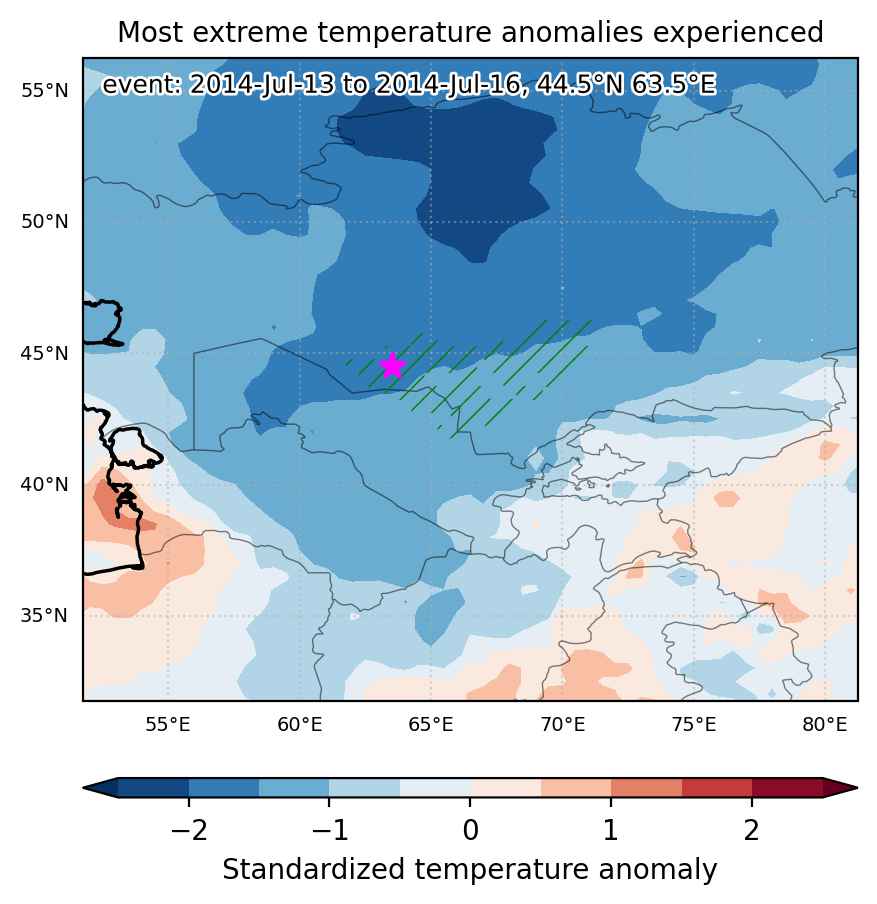

Fig. 1: Map of most extreme temperature anomalies (standardized) experienced during the event. The purple star indicates the center of the extreme event. Green hatching illustrates all areas under the effect of extremes at some time during the event.
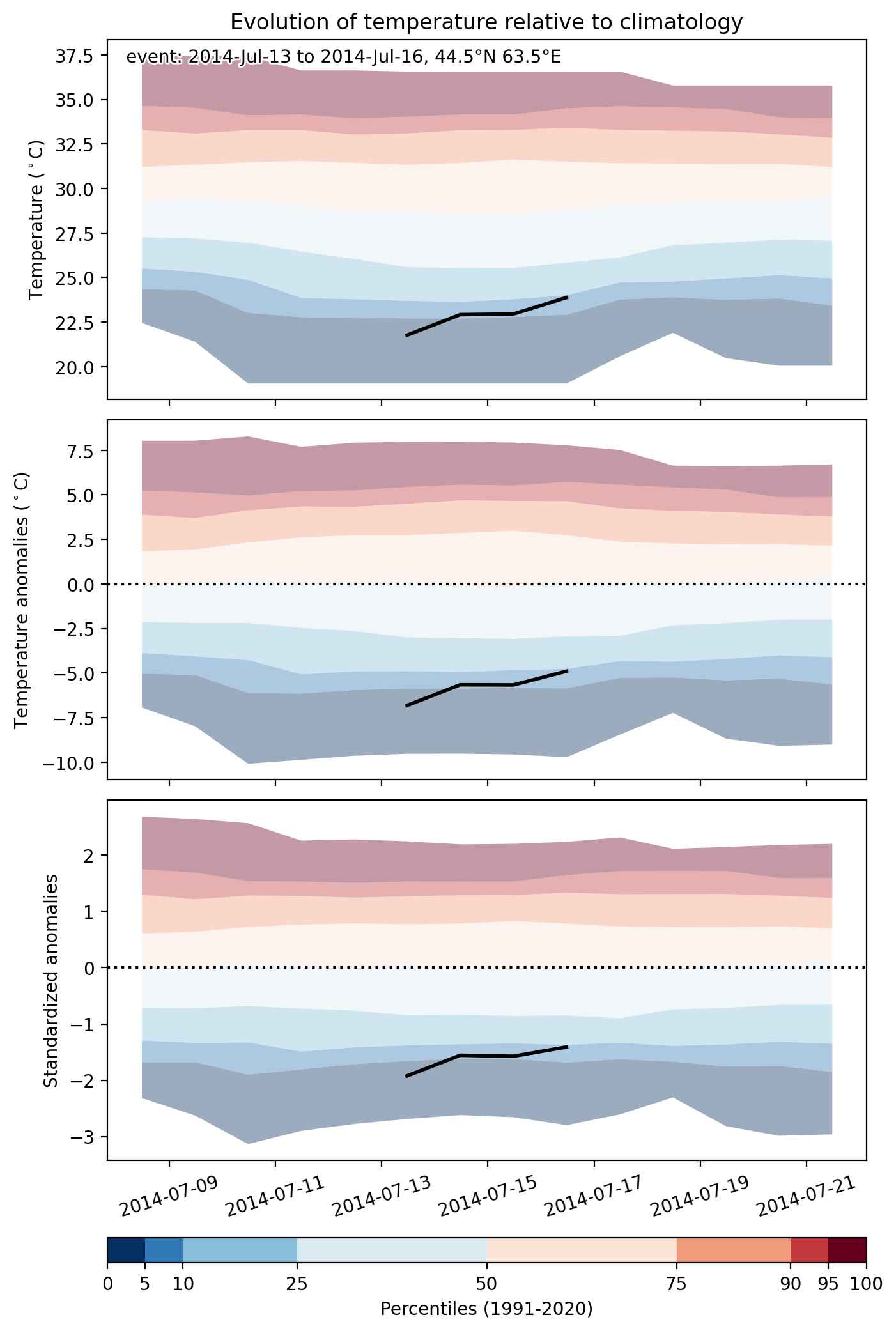


Fig. 2: Evolution of temperature at the center of the event. The climatological percentile distribution is illustrated with color shadings.
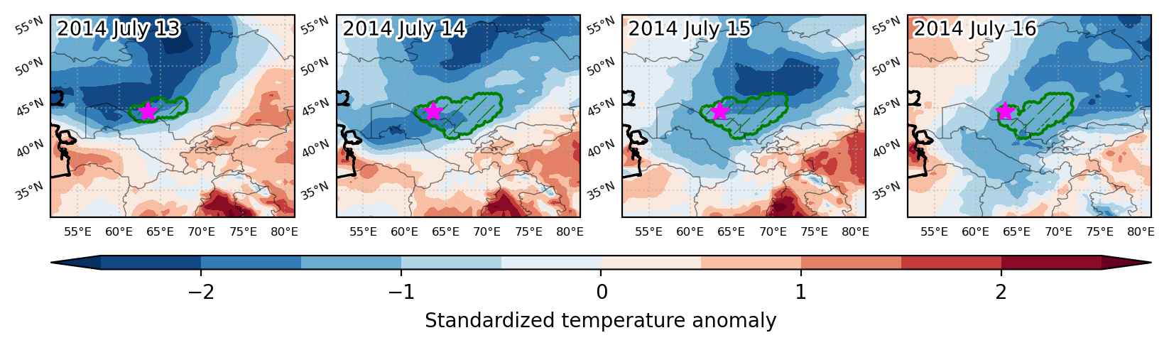


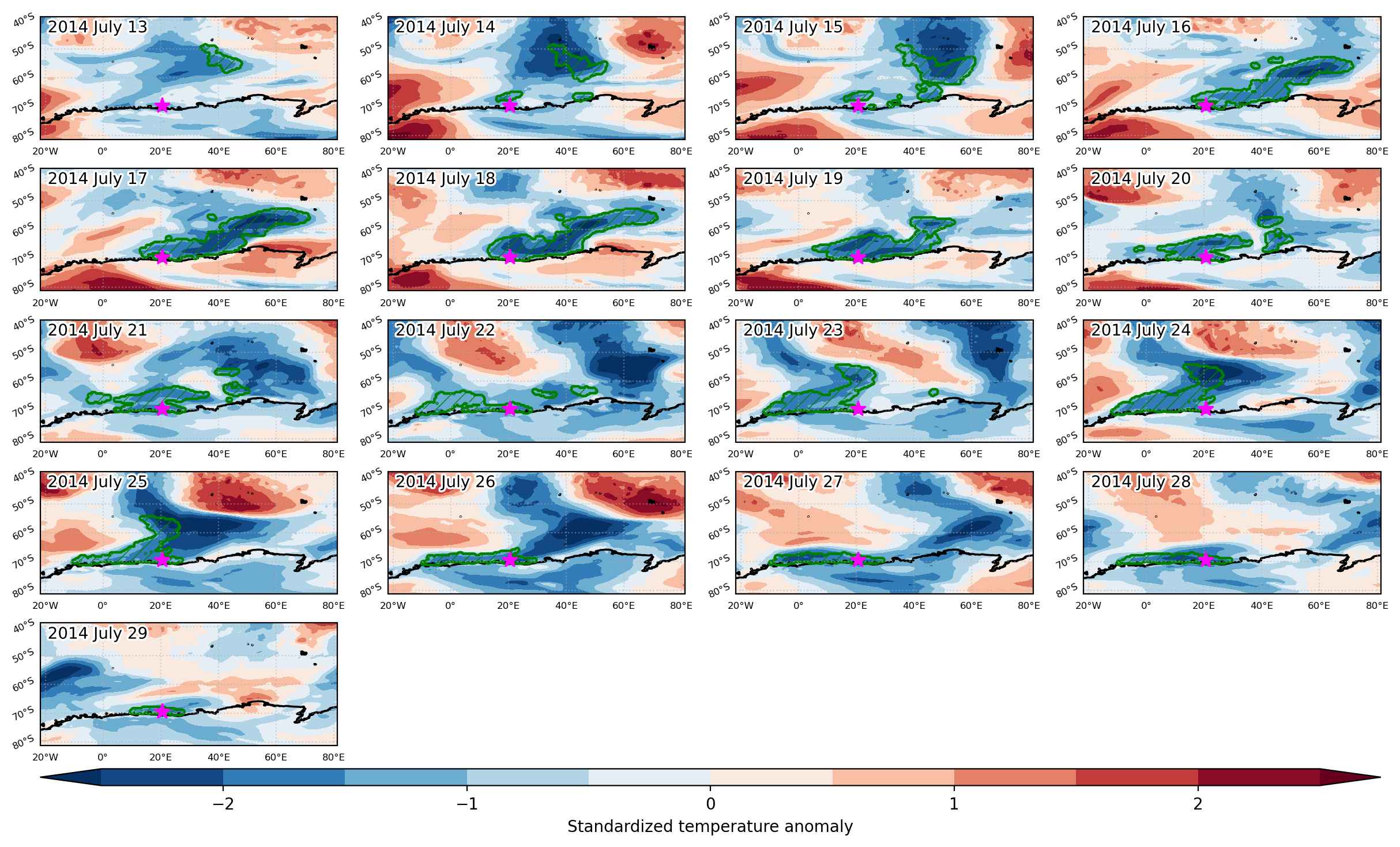
Fig. 3: Maps illustrating the evolution of standardized temperature anomalies during the event.

Event ID: Cold_spell_2014-Jul-13_to_2014-Jul-16_63.5_44.5
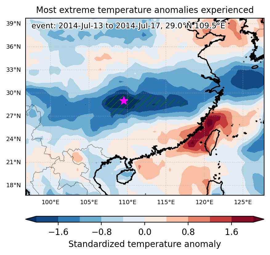
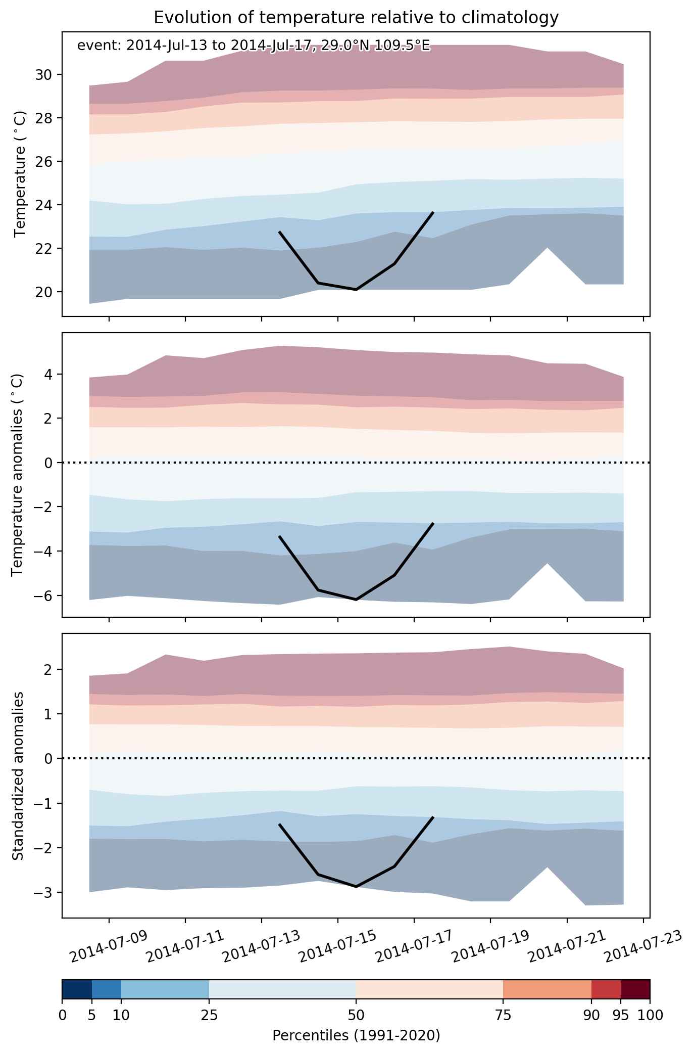
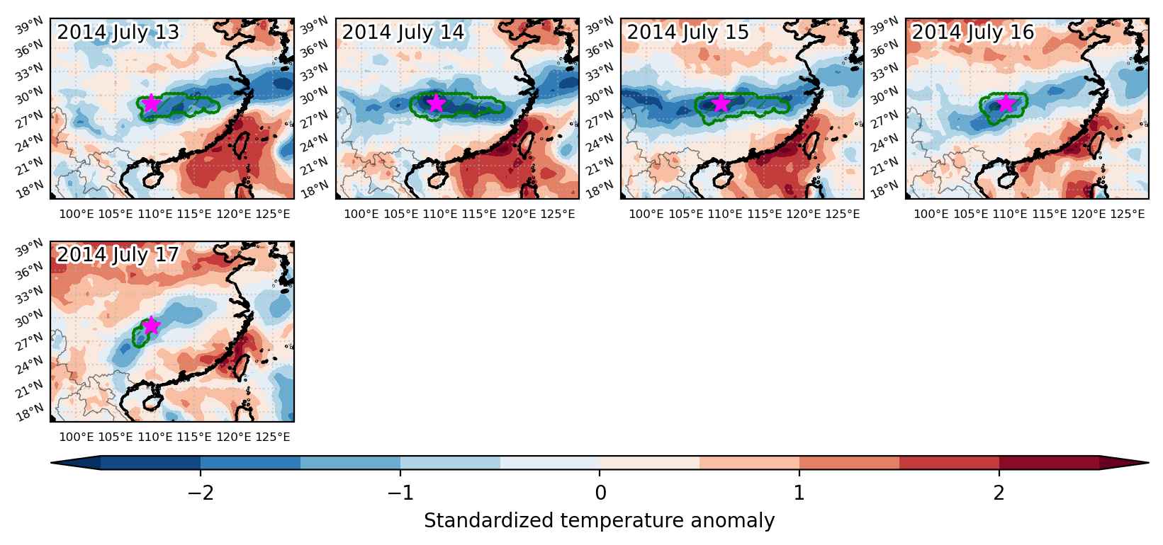
Cold spell occuring from July 13 2014 to July 17 2014 at 29.0°N 109.5°E

Download data: JSON

Event type: Cold spell

Countries affected (identified with ArcGIS Online; provided only for geographical reference):

  • China

Duration: 5 days

Time span: July 13 2014 to July 17 2014

Statistics over entire affected area:

  • Mean temperature anomaly: -4.5 °C
  • Mean temperature: 22.5 °C
  • Minimum temperature anomaly: -6.2 °C
  • Minimum temperature: 18.3 °C

Event center: 29.0°N 109.5°E

Area affected: 178981 km$^2$


Fig. 1: Map of most extreme temperature anomalies (standardized) experienced during the event. The purple star indicates the center of the extreme event. Green hatching illustrates all areas under the effect of extremes at some time during the event.


Fig. 2: Evolution of temperature at the center of the event. The climatological percentile distribution is illustrated with color shadings.


Fig. 3: Maps illustrating the evolution of standardized temperature anomalies during the event.

Event ID: Cold_spell_2014-Jul-13_to_2014-Jul-17_109.5_29.0

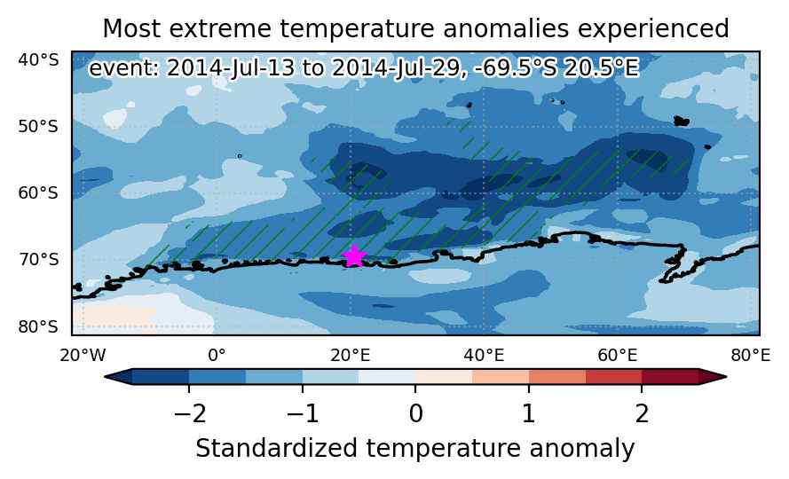
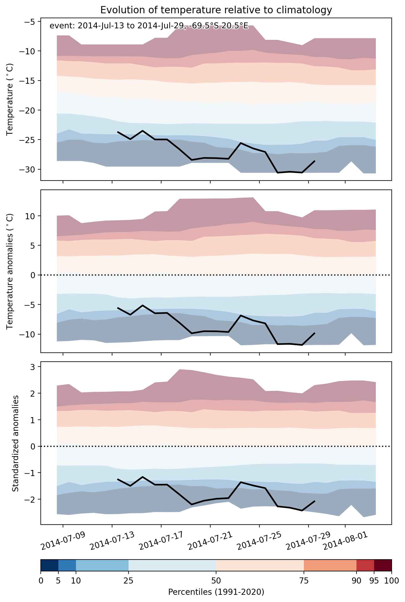
Cold spell occuring from July 13 2014 to July 29 2014 at -69.5°S 20.5°E

Download data: JSON

Event type: Cold spell

Countries affected (identified with ArcGIS Online; provided only for geographical reference):

  • Antarctica

Duration: 17 days

Time span: July 13 2014 to July 29 2014

Statistics over entire affected area:

  • Mean temperature anomaly: -7.8 °C
  • Mean temperature: -20.1 °C
  • Minimum temperature anomaly: -14.9 °C
  • Minimum temperature: -37.1 °C

Event center: -69.5°S 20.5°E

Area affected: 3321852 km$^2$


Fig. 1: Map of most extreme temperature anomalies (standardized) experienced during the event. The purple star indicates the center of the extreme event. Green hatching illustrates all areas under the effect of extremes at some time during the event.


Fig. 2: Evolution of temperature at the center of the event. The climatological percentile distribution is illustrated with color shadings.


Fig. 3: Maps illustrating the evolution of standardized temperature anomalies during the event.

Event ID: Cold_spell_2014-Jul-13_to_2014-Jul-29_20.5_-69.5

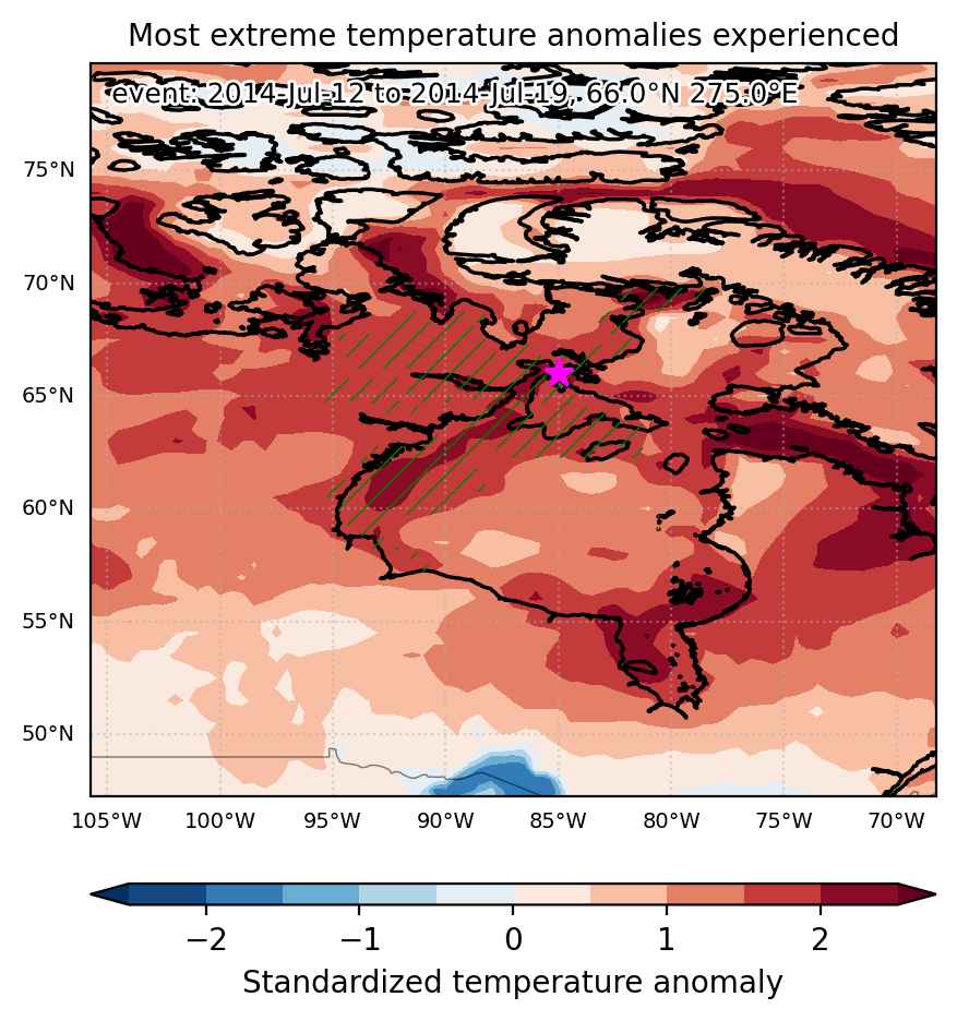
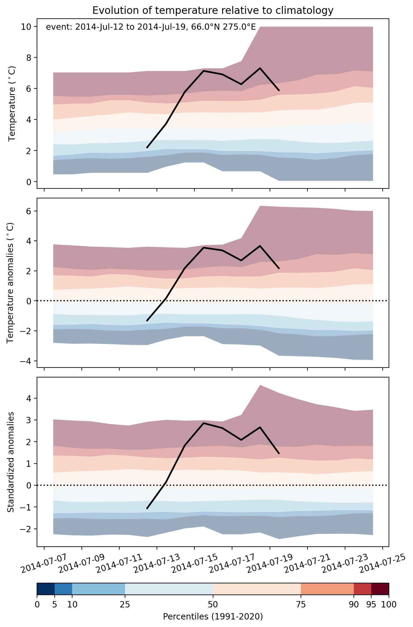
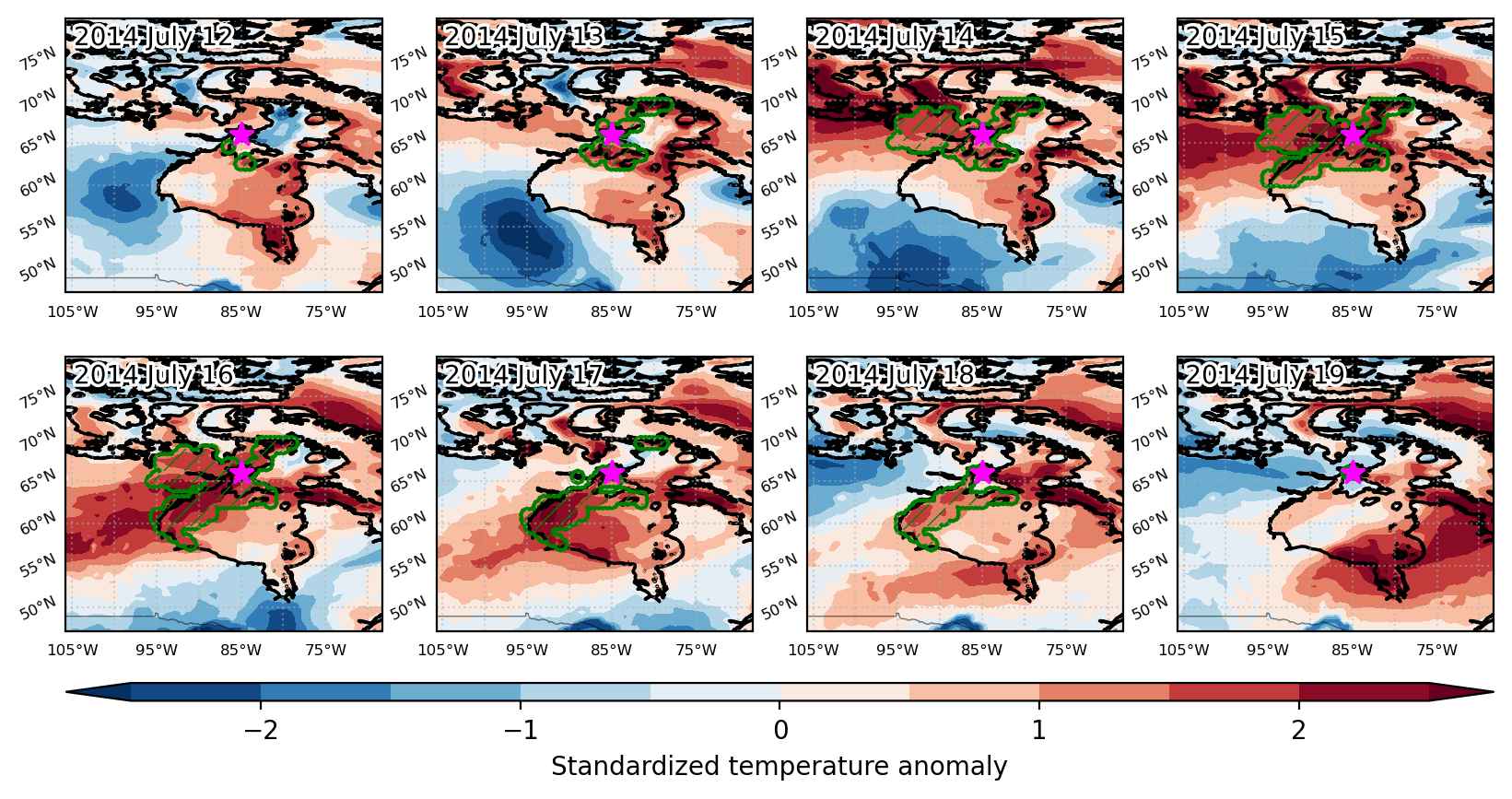
Heat wave occuring from July 12 2014 to July 19 2014 at 66.0°N 275.0°E

Download data: JSON

Event type: Heat wave

Countries affected (identified with ArcGIS Online; provided only for geographical reference):

  • Canada

Duration: 8 days

Time span: July 12 2014 to July 19 2014

Statistics over entire affected area:

  • Mean temperature anomaly: 4.6 °C
  • Mean temperature: 12.5 °C
  • Maximum temperature anomaly: 8.2 °C
  • Maximum temperature: 20.5 °C

Event center: 66.0°N 275.0°E

Area affected: 388500 km$^2$


Fig. 1: Map of most extreme temperature anomalies (standardized) experienced during the event. The purple star indicates the center of the extreme event. Green hatching illustrates all areas under the effect of extremes at some time during the event.


Fig. 2: Evolution of temperature at the center of the event. The climatological percentile distribution is illustrated with color shadings.


Fig. 3: Maps illustrating the evolution of standardized temperature anomalies during the event.

Event ID: Heat_wave_2014-Jul-12_to_2014-Jul-19_275.0_66.0

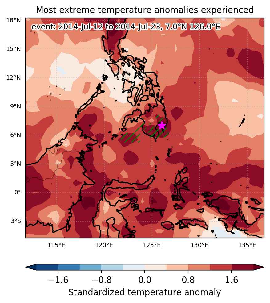
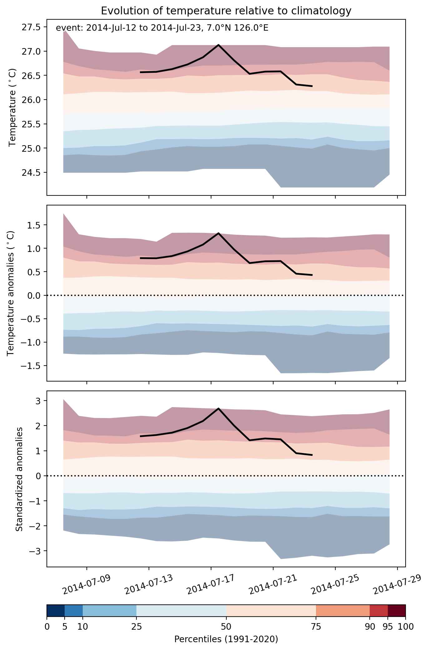
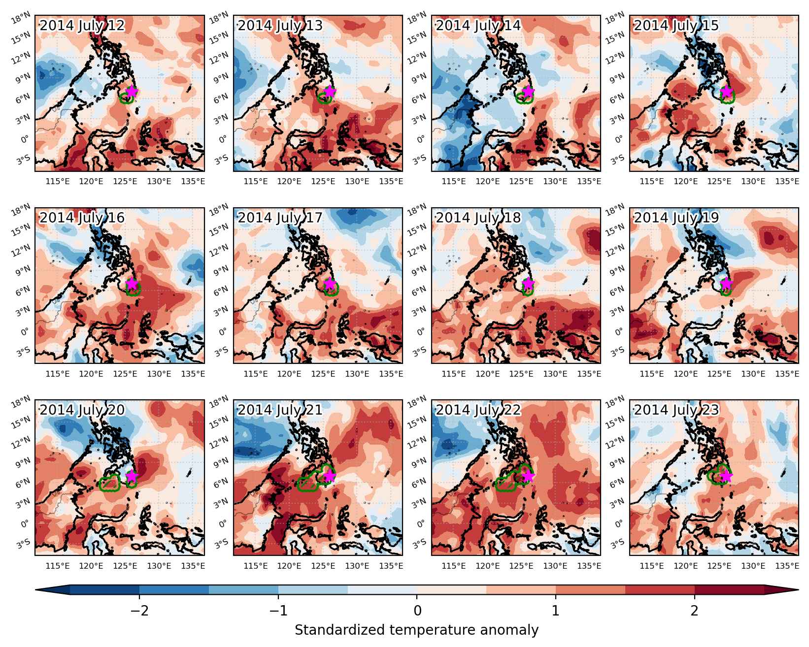
Heat wave occuring from July 12 2014 to July 23 2014 at 7.0°N 126.0°E

Download data: JSON

Event type: Heat wave

Countries affected (identified with ArcGIS Online; provided only for geographical reference):

  • Philippines

Duration: 12 days

Time span: July 12 2014 to July 23 2014

Statistics over entire affected area:

  • Mean temperature anomaly: 1.1 °C
  • Mean temperature: 27.7 °C
  • Maximum temperature anomaly: 2.1 °C
  • Maximum temperature: 28.7 °C

Event center: 7.0°N 126.0°E

Area affected: 70657 km$^2$


Fig. 1: Map of most extreme temperature anomalies (standardized) experienced during the event. The purple star indicates the center of the extreme event. Green hatching illustrates all areas under the effect of extremes at some time during the event.


Fig. 2: Evolution of temperature at the center of the event. The climatological percentile distribution is illustrated with color shadings.


Fig. 3: Maps illustrating the evolution of standardized temperature anomalies during the event.

Event ID: Heat_wave_2014-Jul-12_to_2014-Jul-23_126.0_7.0

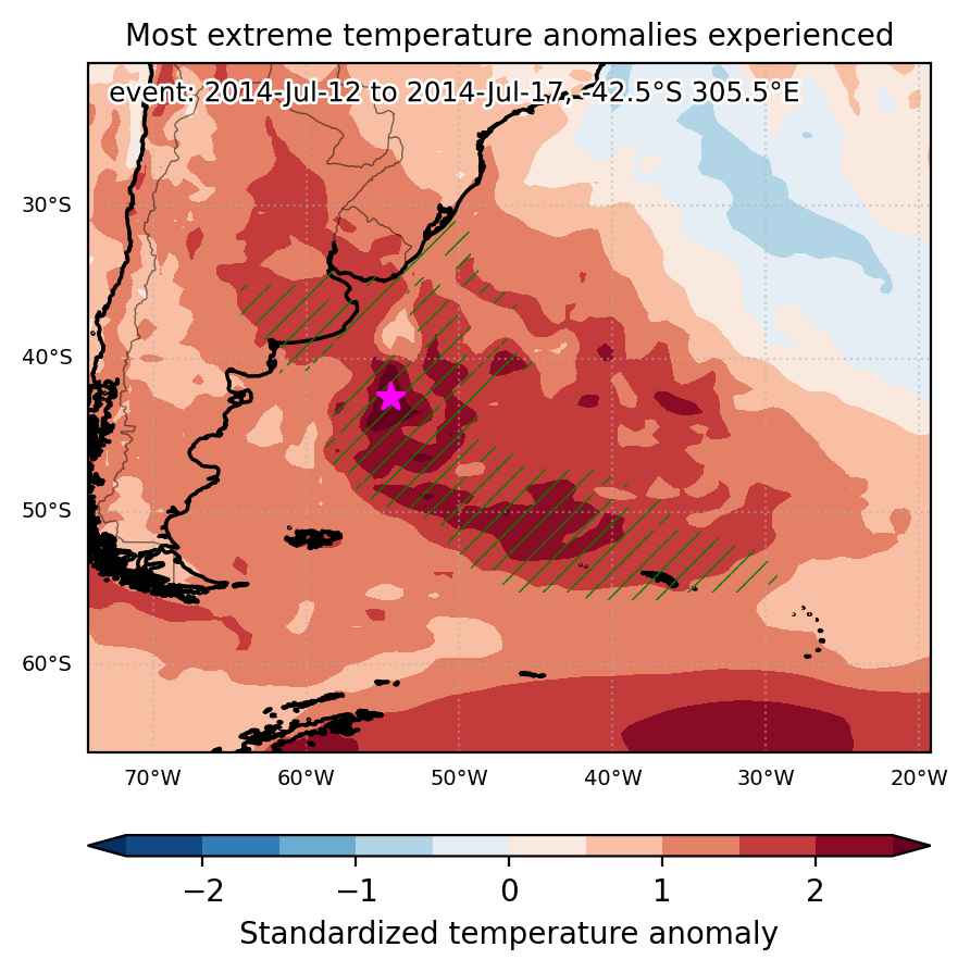
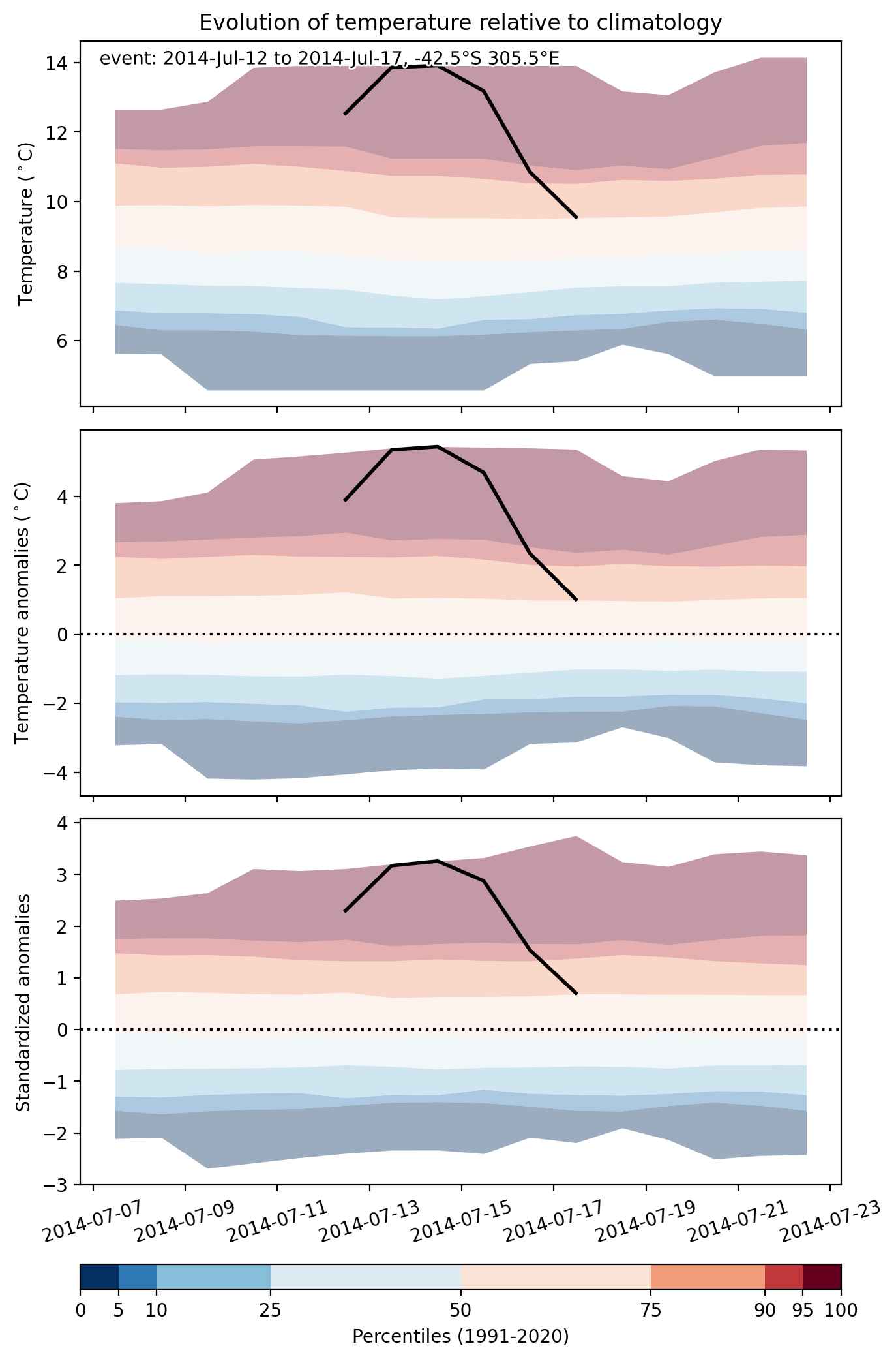
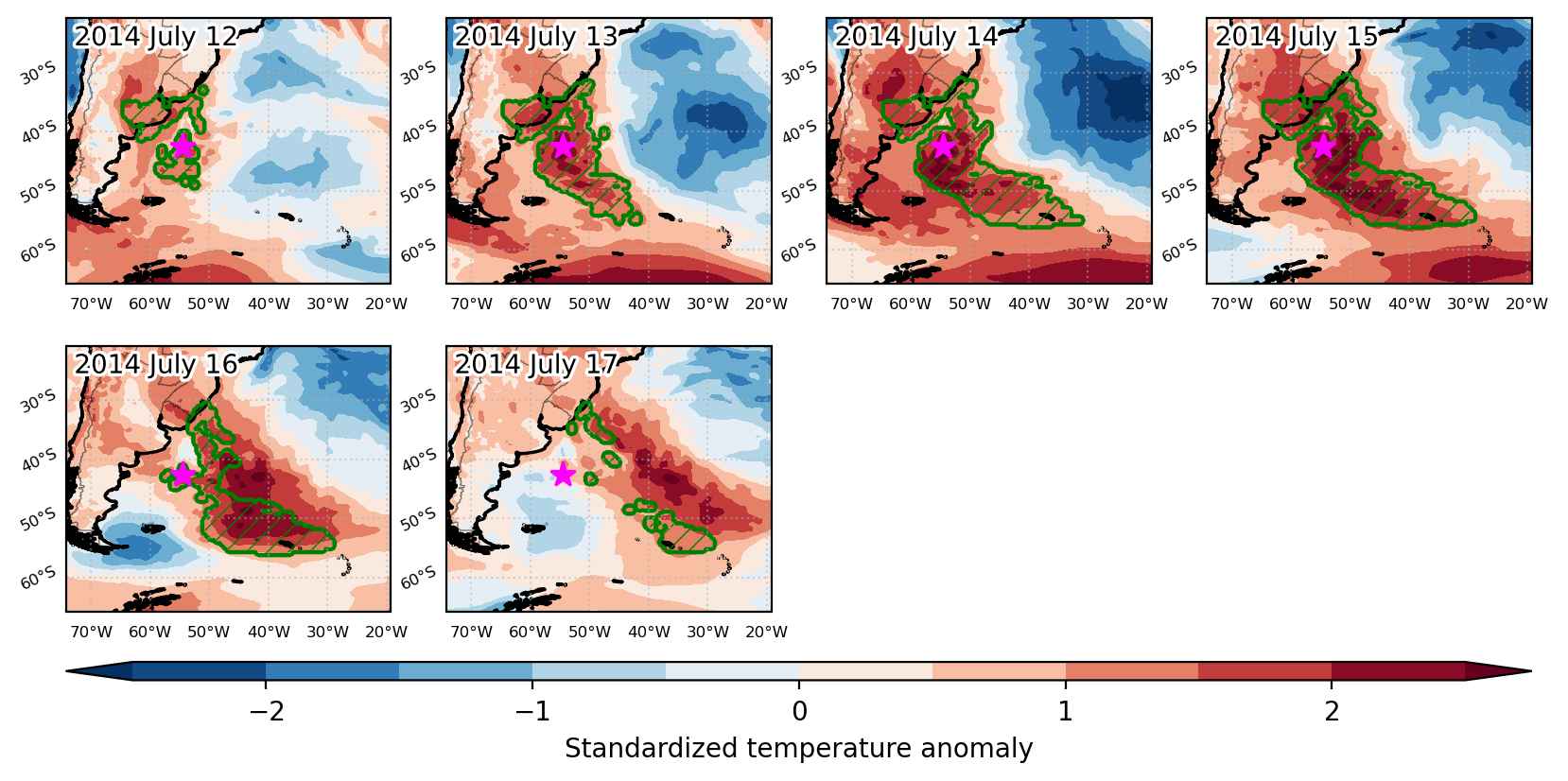
Heat wave occuring from July 12 2014 to July 17 2014 at -42.5°S 305.5°E

Download data: JSON

Event type: Heat wave

Countries affected (identified with ArcGIS Online; provided only for geographical reference):

  • Argentina
  • Brazil
  • South Georgia and the South Sandwich Islands

Duration: 6 days

Time span: July 12 2014 to July 17 2014

Statistics over entire affected area:

  • Mean temperature anomaly: 3.6 °C
  • Mean temperature: 9.3 °C
  • Maximum temperature anomaly: 7.7 °C
  • Maximum temperature: 19.9 °C

Event center: -42.5°S 305.5°E

Area affected: 2274445 km$^2$


Fig. 1: Map of most extreme temperature anomalies (standardized) experienced during the event. The purple star indicates the center of the extreme event. Green hatching illustrates all areas under the effect of extremes at some time during the event.


Fig. 2: Evolution of temperature at the center of the event. The climatological percentile distribution is illustrated with color shadings.


Fig. 3: Maps illustrating the evolution of standardized temperature anomalies during the event.

Event ID: Heat_wave_2014-Jul-12_to_2014-Jul-17_305.5_-42.5

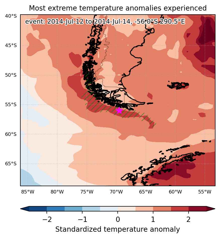
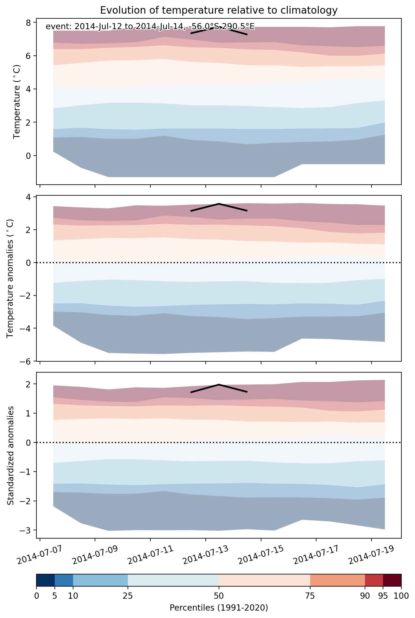
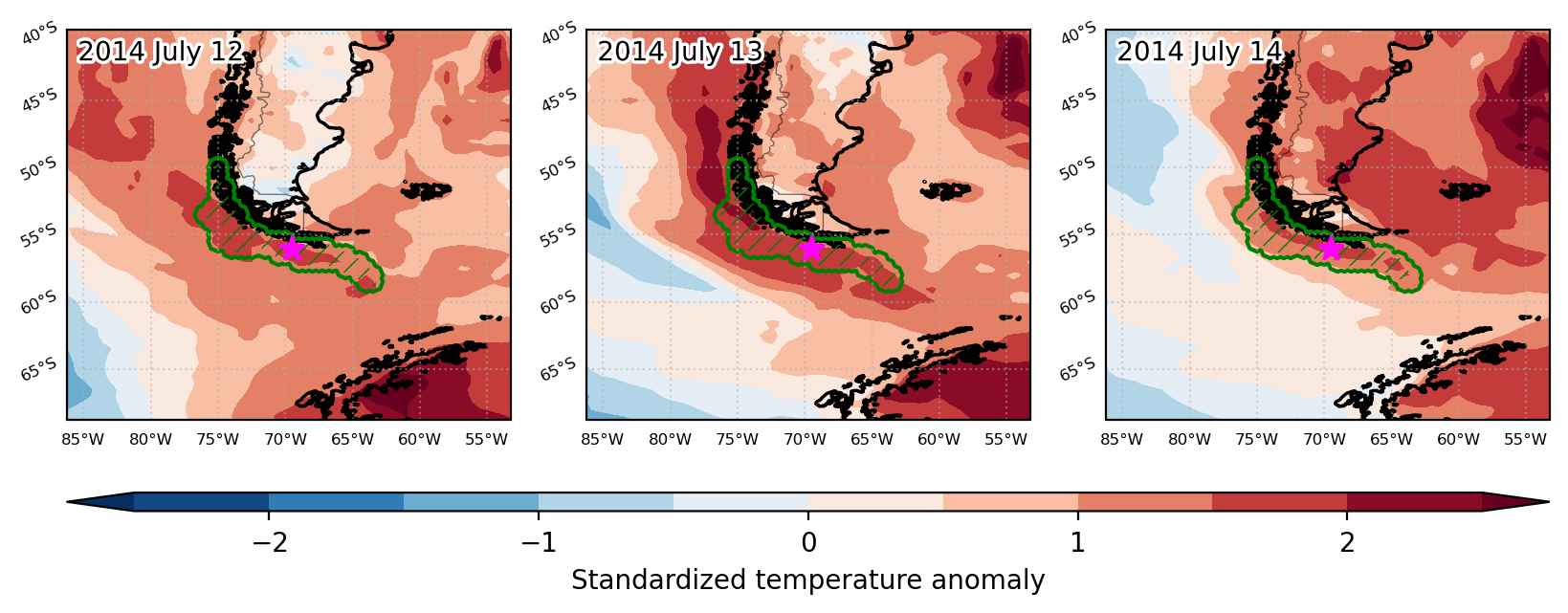
Heat wave occuring from July 12 2014 to July 14 2014 at -56.0°S 290.5°E

Download data: JSON

Event type: Heat wave

Countries affected (identified with ArcGIS Online; provided only for geographical reference):

  • Chile

Duration: 3 days

Time span: July 12 2014 to July 14 2014

Statistics over entire affected area:

  • Mean temperature anomaly: 2.8 °C
  • Mean temperature: 6.7 °C
  • Maximum temperature anomaly: 4.6 °C
  • Maximum temperature: 8.4 °C

Event center: -56.0°S 290.5°E

Area affected: 158312 km$^2$


Fig. 1: Map of most extreme temperature anomalies (standardized) experienced during the event. The purple star indicates the center of the extreme event. Green hatching illustrates all areas under the effect of extremes at some time during the event.


Fig. 2: Evolution of temperature at the center of the event. The climatological percentile distribution is illustrated with color shadings.


Fig. 3: Maps illustrating the evolution of standardized temperature anomalies during the event.

Event ID: Heat_wave_2014-Jul-12_to_2014-Jul-14_290.5_-56.0

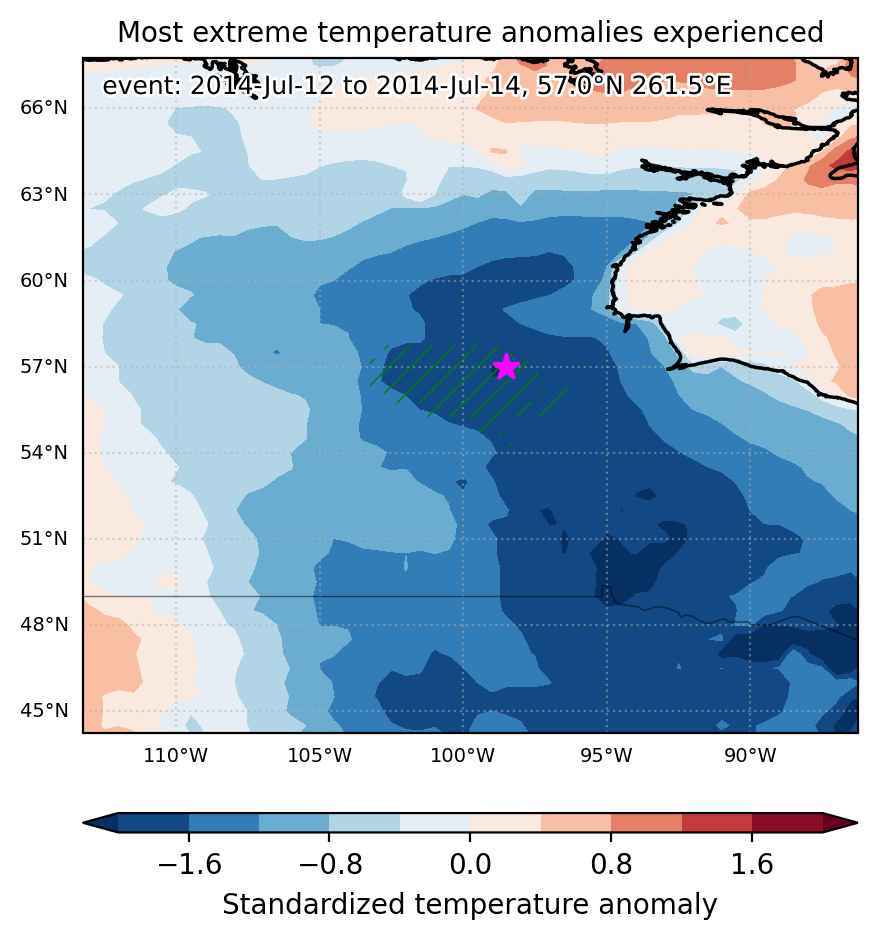
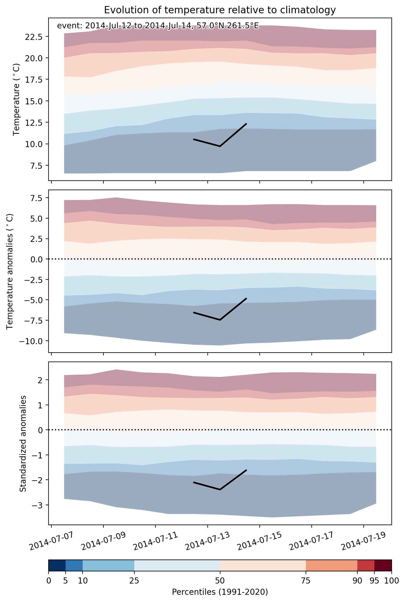
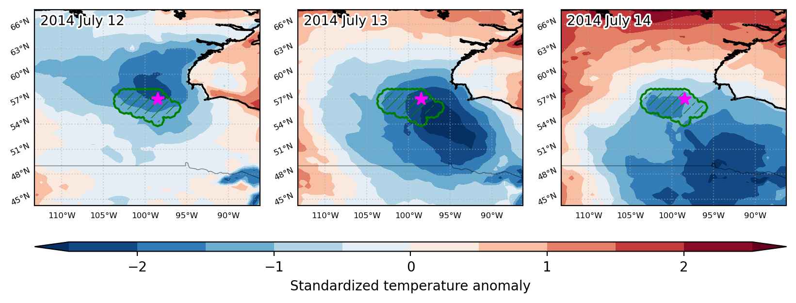
Cold spell occuring from July 12 2014 to July 14 2014 at 57.0°N 261.5°E

Download data: JSON

Event type: Cold spell

Countries affected (identified with ArcGIS Online; provided only for geographical reference):

  • Canada

Duration: 3 days

Time span: July 12 2014 to July 14 2014

Statistics over entire affected area:

  • Mean temperature anomaly: -5.4 °C
  • Mean temperature: 11.8 °C
  • Minimum temperature anomaly: -8.8 °C
  • Minimum temperature: 9.0 °C

Event center: 57.0°N 261.5°E

Area affected: 95779 km$^2$


Fig. 1: Map of most extreme temperature anomalies (standardized) experienced during the event. The purple star indicates the center of the extreme event. Green hatching illustrates all areas under the effect of extremes at some time during the event.


Fig. 2: Evolution of temperature at the center of the event. The climatological percentile distribution is illustrated with color shadings.


Fig. 3: Maps illustrating the evolution of standardized temperature anomalies during the event.

Event ID: Cold_spell_2014-Jul-12_to_2014-Jul-14_261.5_57.0

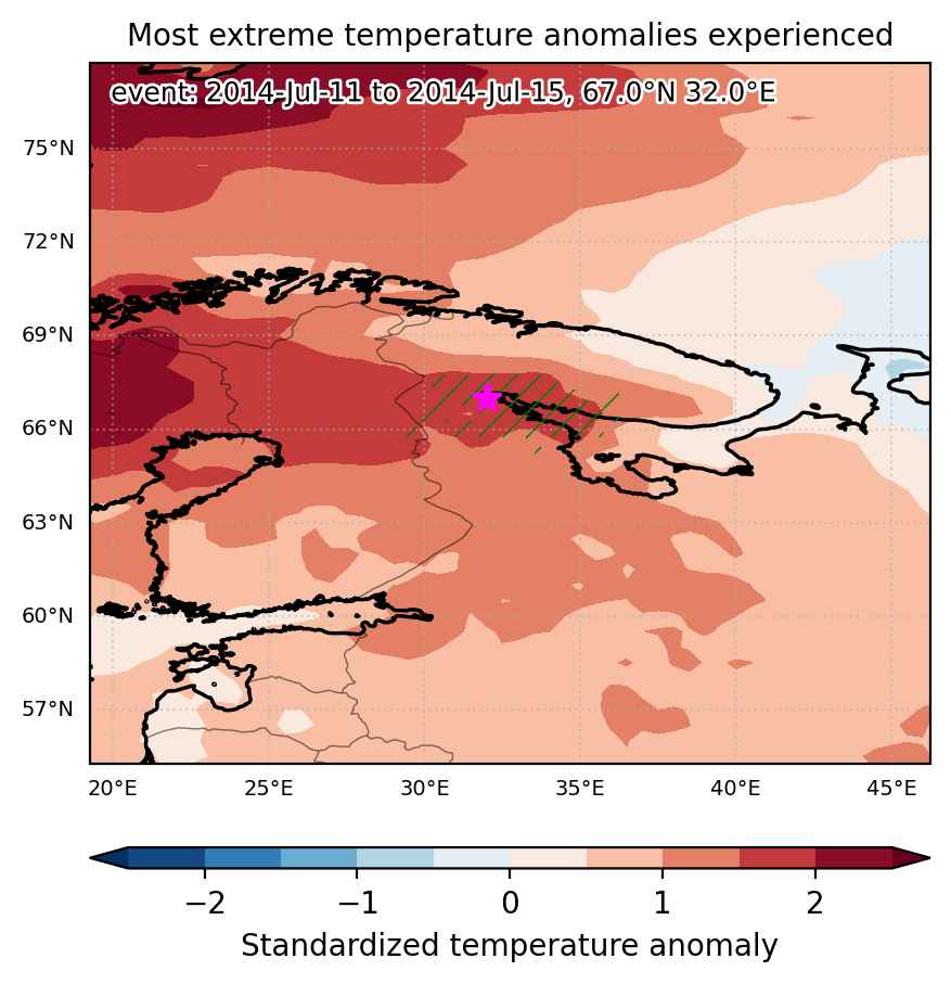
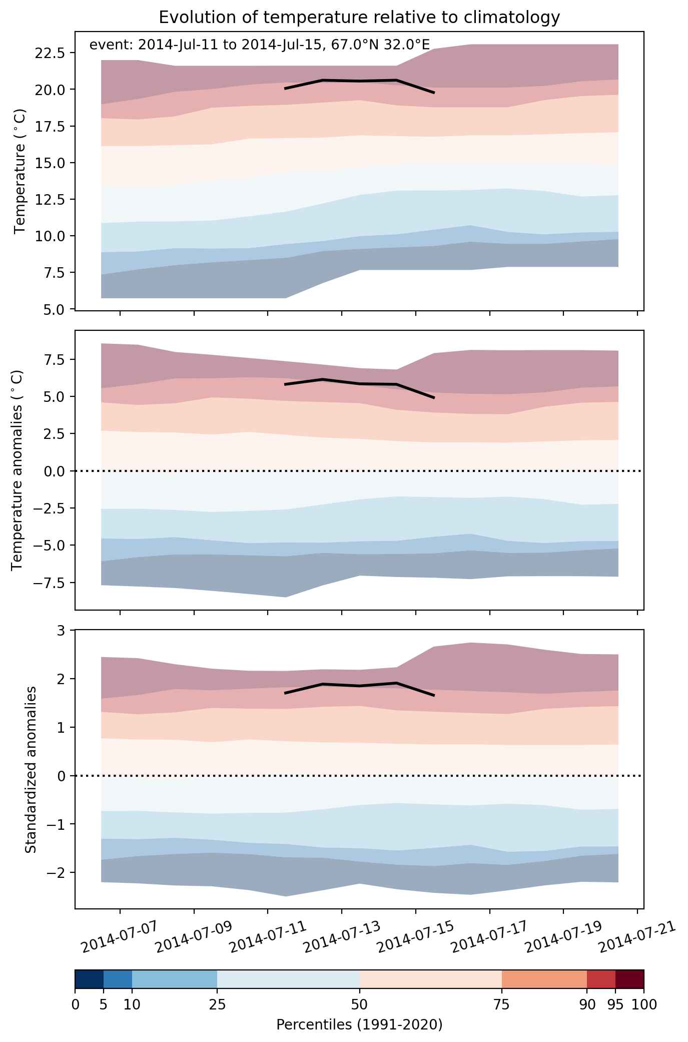
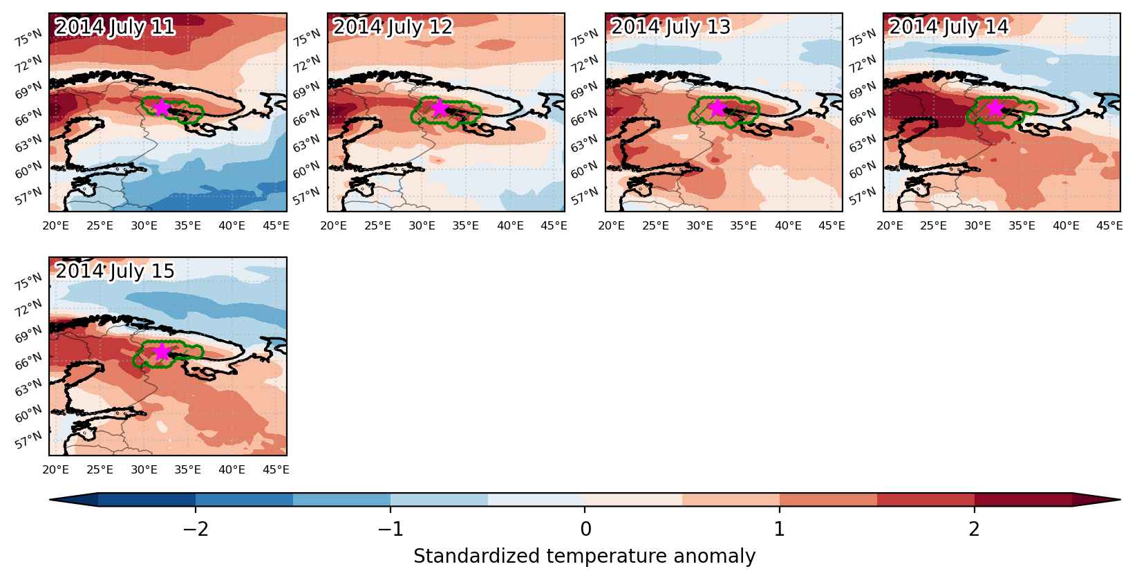
Heat wave occuring from July 11 2014 to July 15 2014 at 67.0°N 32.0°E

Download data: JSON

Event type: Heat wave

Countries affected (identified with ArcGIS Online; provided only for geographical reference):

  • Finland
  • Russian Federation

Duration: 5 days

Time span: July 11 2014 to July 15 2014

Statistics over entire affected area:

  • Mean temperature anomaly: 5.3 °C
  • Mean temperature: 20.2 °C
  • Maximum temperature anomaly: 6.9 °C
  • Maximum temperature: 22.9 °C

Event center: 67.0°N 32.0°E

Area affected: 51418 km$^2$


Fig. 1: Map of most extreme temperature anomalies (standardized) experienced during the event. The purple star indicates the center of the extreme event. Green hatching illustrates all areas under the effect of extremes at some time during the event.


Fig. 2: Evolution of temperature at the center of the event. The climatological percentile distribution is illustrated with color shadings.


Fig. 3: Maps illustrating the evolution of standardized temperature anomalies during the event.

Event ID: Heat_wave_2014-Jul-11_to_2014-Jul-15_32.0_67.0

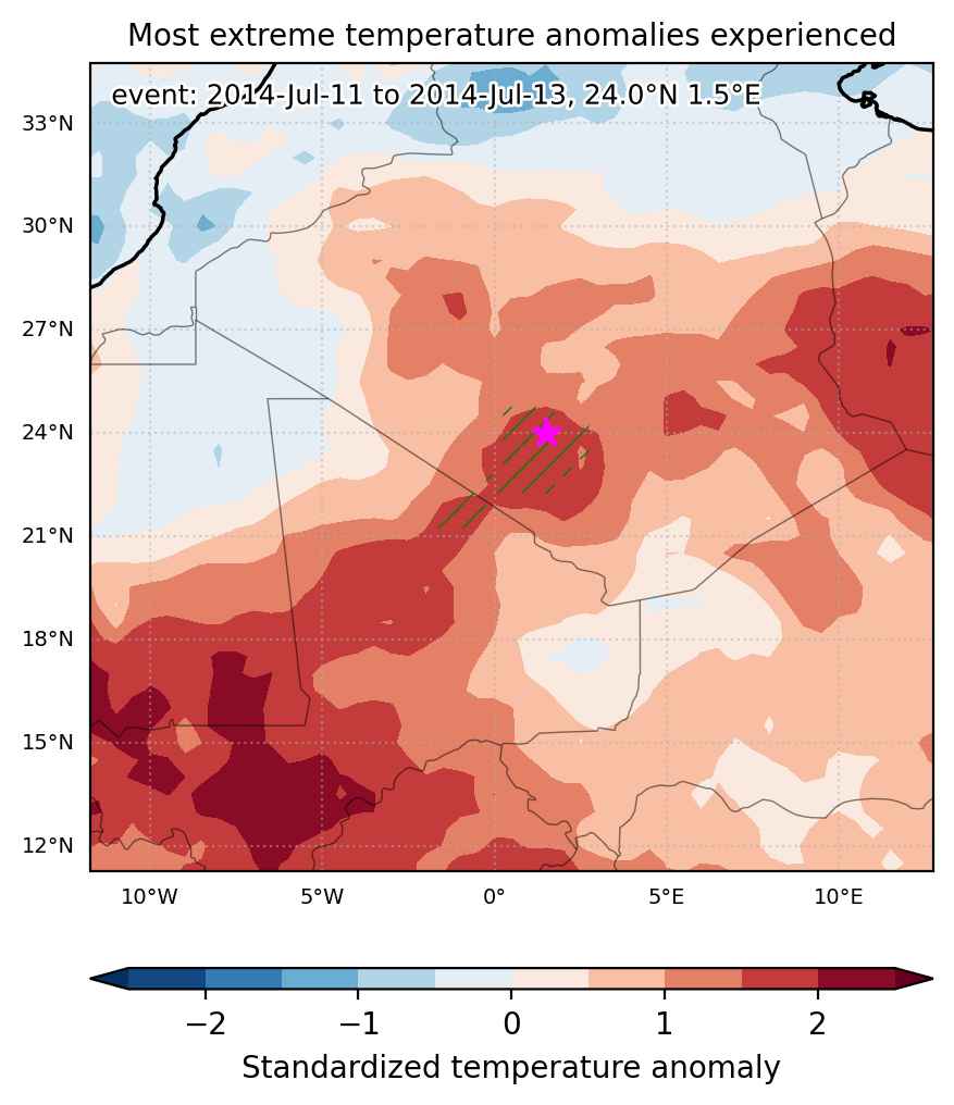
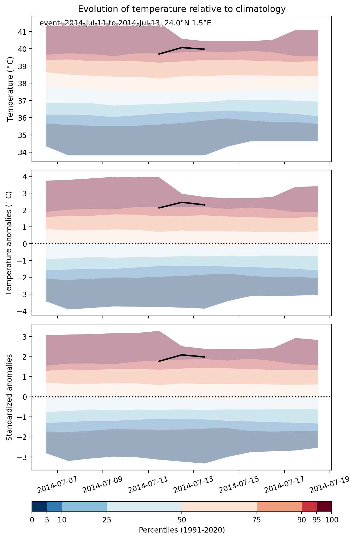
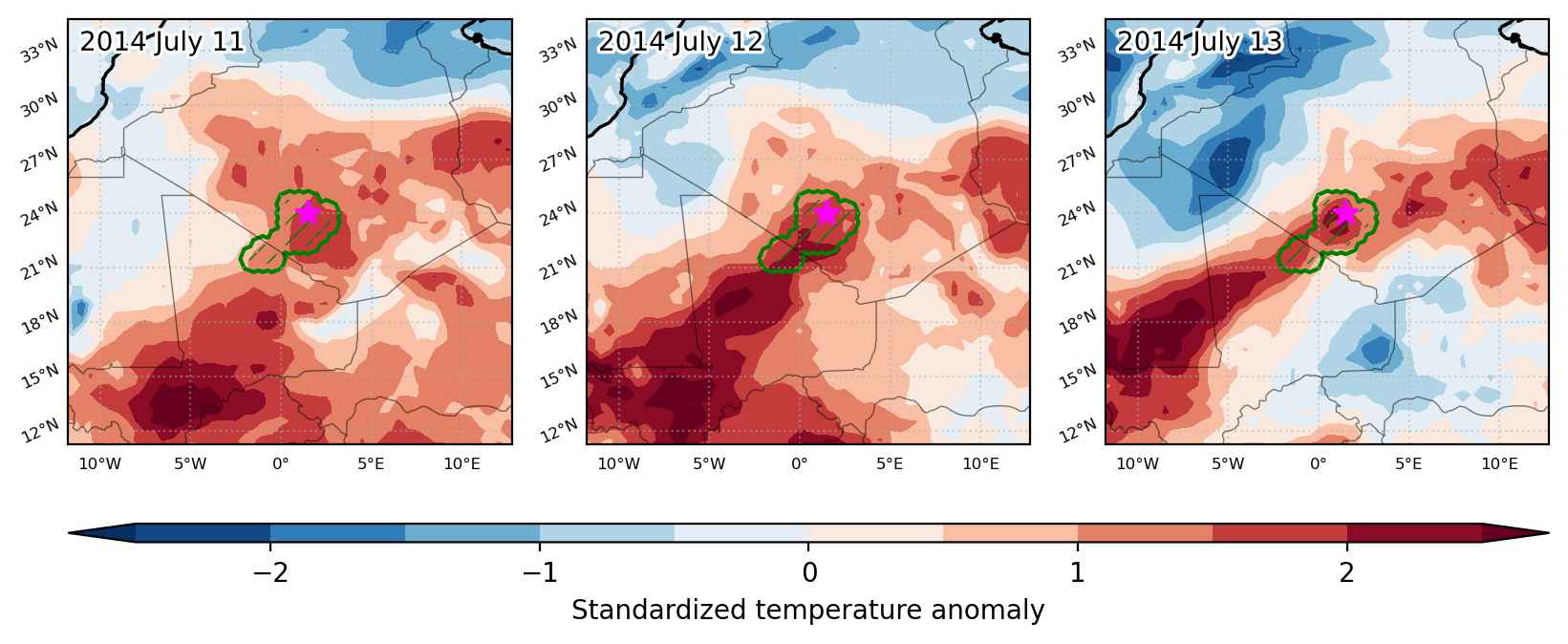
Heat wave occuring from July 11 2014 to July 13 2014 at 24.0°N 1.5°E

Download data: JSON

Event type: Heat wave

Countries affected (identified with ArcGIS Online; provided only for geographical reference):

  • Algeria
  • Mali

Duration: 3 days

Time span: July 11 2014 to July 13 2014

Statistics over entire affected area:

  • Mean temperature anomaly: 2.0 °C
  • Mean temperature: 39.2 °C
  • Maximum temperature anomaly: 2.8 °C
  • Maximum temperature: 40.6 °C

Event center: 24.0°N 1.5°E

Area affected: 71071 km$^2$


Fig. 1: Map of most extreme temperature anomalies (standardized) experienced during the event. The purple star indicates the center of the extreme event. Green hatching illustrates all areas under the effect of extremes at some time during the event.


Fig. 2: Evolution of temperature at the center of the event. The climatological percentile distribution is illustrated with color shadings.


Fig. 3: Maps illustrating the evolution of standardized temperature anomalies during the event.

Event ID: Heat_wave_2014-Jul-11_to_2014-Jul-13_1.5_24.0