Heat wave occuring from December 04 2020 to December 07 2020 at 46.5°N 22.5°E

Download data: JSON

Event type: Heat wave

Countries affected (identified with ArcGIS Online; provided only for geographical reference):

  • Austria
  • Czechia
  • Hungary
  • Poland
  • Romania
  • Slovakia
  • Ukraine

Duration: 4 days

Time span: December 04 2020 to December 07 2020

Statistics over entire affected area:

  • Mean temperature anomaly: 6.4 °C
  • Mean temperature: 7.0 °C
  • Maximum temperature anomaly: 9.8 °C
  • Maximum temperature: 11.1 °C

Event center: 46.5°N 22.5°E

Area affected: 201432 km$^2$
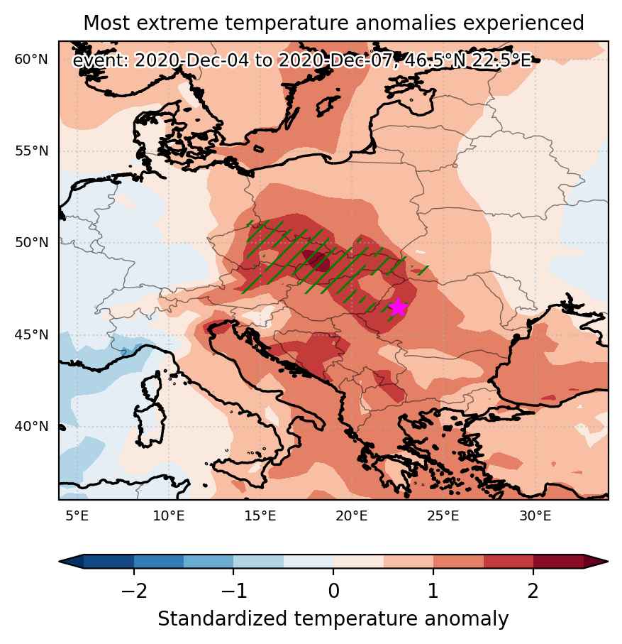

Fig. 1: Map of most extreme temperature anomalies (standardized) experienced during the event. The purple star indicates the center of the extreme event. Green hatching illustrates all areas under the effect of extremes at some time during the event.
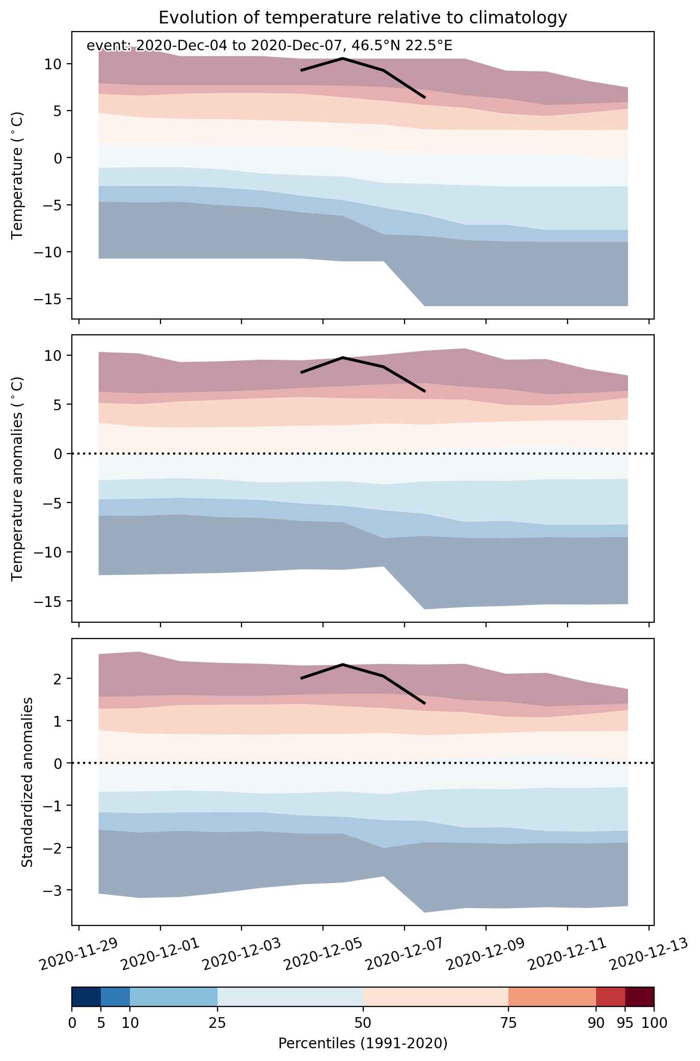


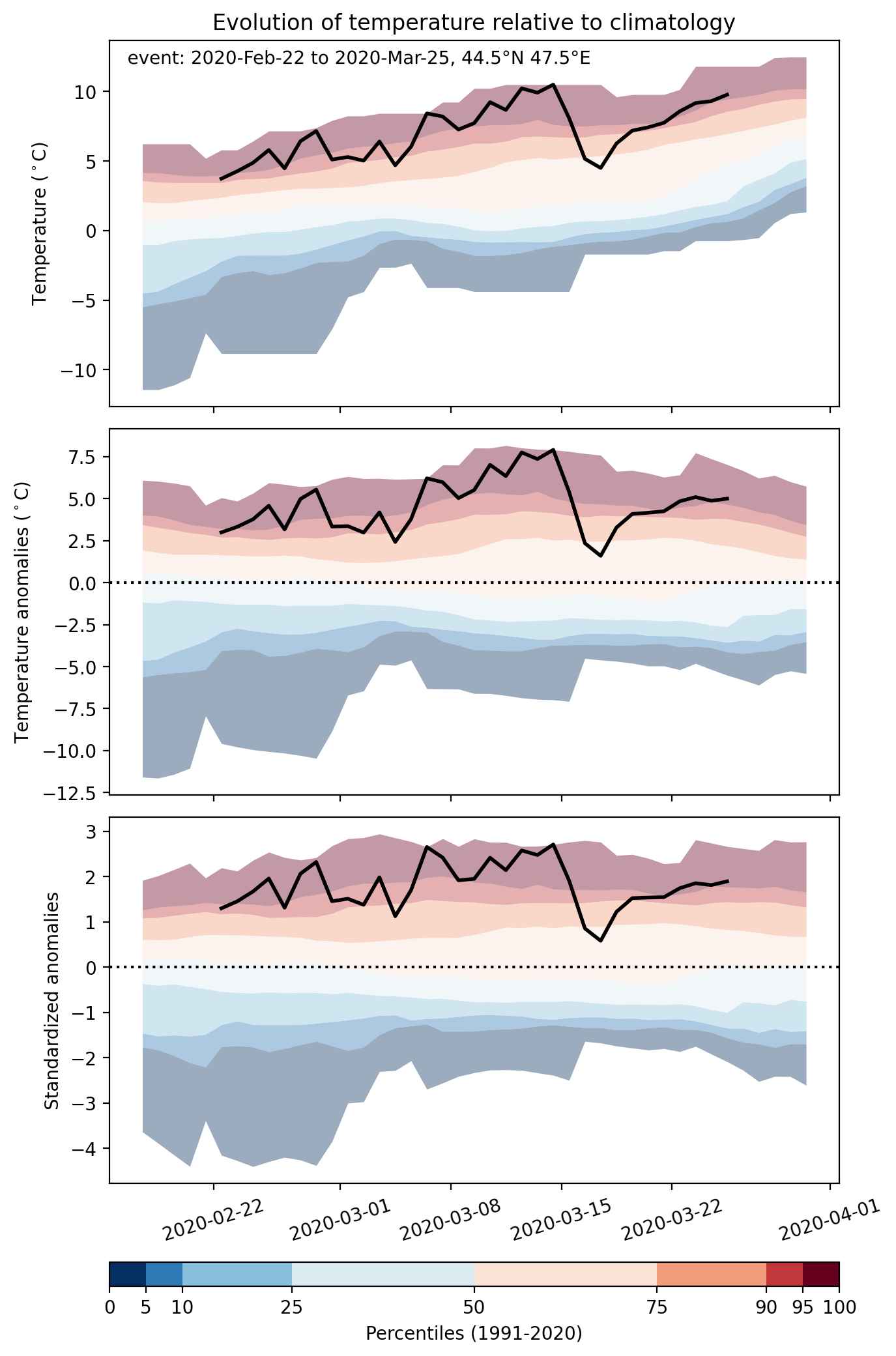
Fig. 2: Evolution of temperature at the center of the event. The climatological percentile distribution is illustrated with color shadings.
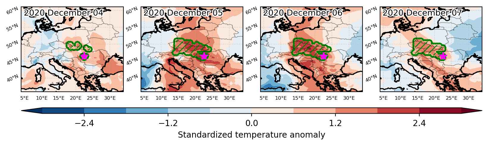


Fig. 3: Maps illustrating the evolution of standardized temperature anomalies during the event.

Event ID: Heat_wave_2020-Dec-04_to_2020-Dec-07_22.5_46.5
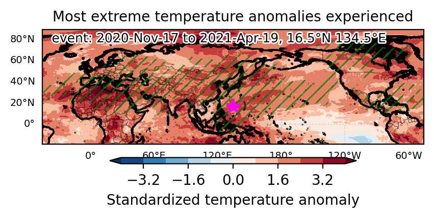
Heat wave occuring from November 17 2020 to April 19 2021 at 16.5°N 134.5°E

Download data: JSON

Event type: Heat wave

Countries affected (identified with ArcGIS Online; provided only for geographical reference):

  • Afghanistan
  • Albania
  • Algeria
  • Andorra
  • Armenia
  • Aruba
  • Austria
  • Azerbaijan
  • Bahamas
  • Bahrain
  • Bangladesh
  • Belarus
  • Belize
  • Bhutan
  • Bonaire, Sint Eustatius and Saba
  • Bosnia and Herzegovina
  • Bulgaria
  • Cambodia
  • Cameroon
  • Canada
  • Central African Republic
  • Chad
  • China
  • Colombia
  • Costa Rica
  • Croatia
  • Cuba
  • Cyprus
  • Czechia
  • Denmark
  • Djibouti
  • Dominican Republic
  • Egypt
  • El Salvador
  • Eritrea
  • Estonia
  • Ethiopia
  • Finland
  • France
  • Georgia
  • Germany
  • Greece
  • Greenland
  • Guatemala
  • Haiti
  • Honduras
  • Hong Kong
  • Hungary
  • India
  • Indonesia
  • Iran, Islamic Republic of
  • Iraq
  • Israel
  • Italy
  • Jamaica
  • Japan
  • Jordan
  • Kazakhstan
  • Korea, Democratic People’s Republic of
  • Korea, Republic of
  • Kuwait
  • Kyrgyzstan
  • Lao People’s Democratic Republic
  • Latvia
  • Lebanon
  • Libya
  • Lithuania
  • Mali
  • Martinique
  • Mauritania
  • Mexico
  • Moldova, Republic of
  • Mongolia
  • Montenegro
  • Morocco
  • Myanmar
  • Nepal
  • Nicaragua
  • Niger
  • Nigeria
  • North Macedonia
  • Northern Mariana Islands
  • Oman
  • Pakistan
  • Palau
  • Philippines
  • Poland
  • Portugal
  • Puerto Rico
  • Qatar
  • Romania
  • Russian Federation
  • Saudi Arabia
  • Serbia
  • Slovakia
  • Slovenia
  • South Sudan
  • Spain
  • Sri Lanka
  • Sudan
  • Sweden
  • Switzerland
  • Syrian Arab Republic
  • Taiwan, Province of China
  • Tajikistan
  • Thailand
  • Tunisia
  • Turkmenistan
  • Turks and Caicos Islands
  • Türkiye
  • Ukraine
  • United Arab Emirates
  • United States
  • Uzbekistan
  • Viet Nam
  • Yemen

Duration: 154 days

Time span: November 17 2020 to April 19 2021

Statistics over entire affected area:

  • Mean temperature anomaly: 4.3 °C
  • Mean temperature: 16.8 °C
  • Maximum temperature anomaly: 27.4 °C
  • Maximum temperature: 37.1 °C

Event center: 16.5°N 134.5°E

Area affected: 124427445 km$^2$


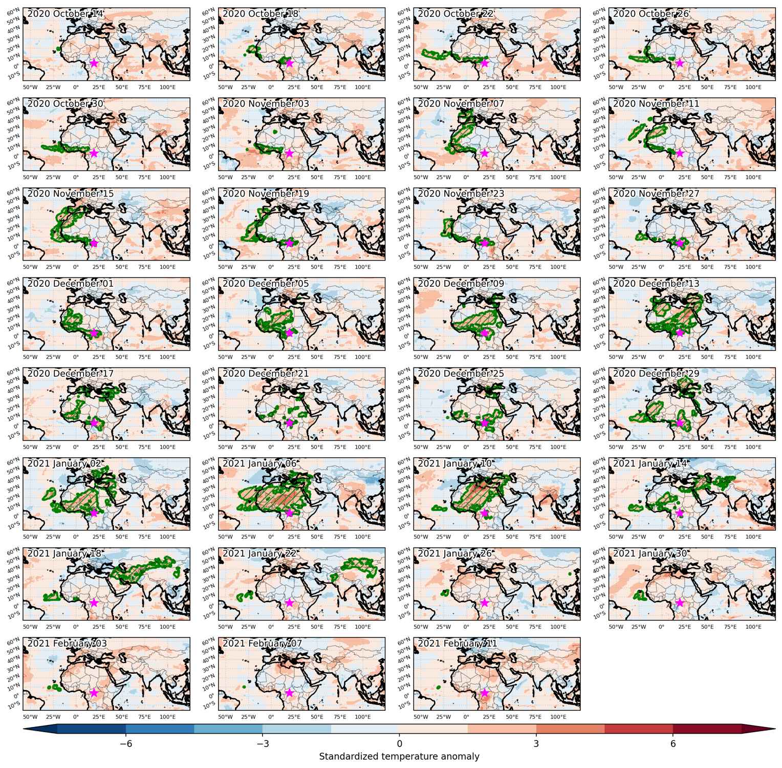
Fig. 1: Map of most extreme temperature anomalies (standardized) experienced during the event. The purple star indicates the center of the extreme event. Green hatching illustrates all areas under the effect of extremes at some time during the event.


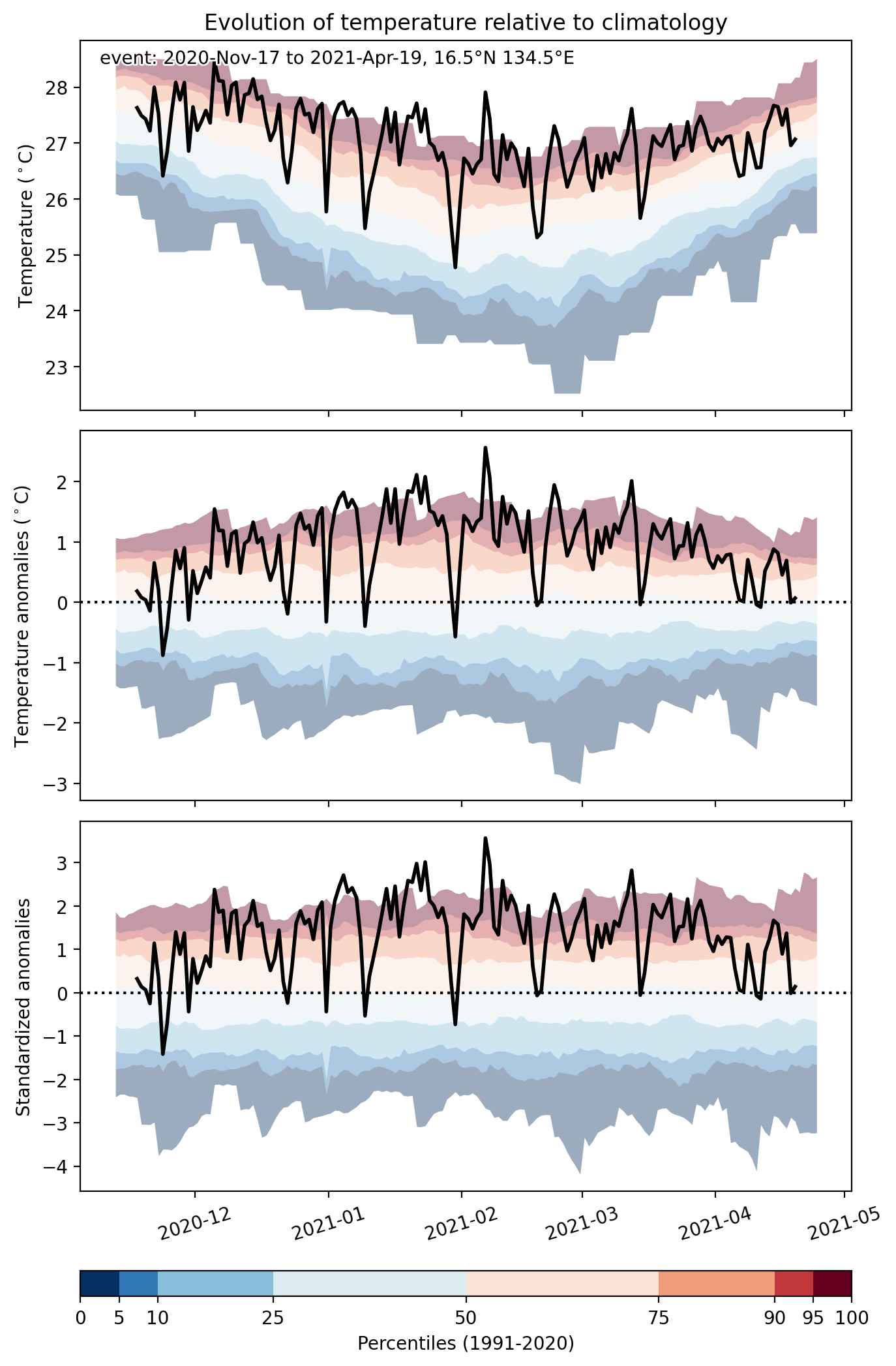
Fig. 2: Evolution of temperature at the center of the event. The climatological percentile distribution is illustrated with color shadings.


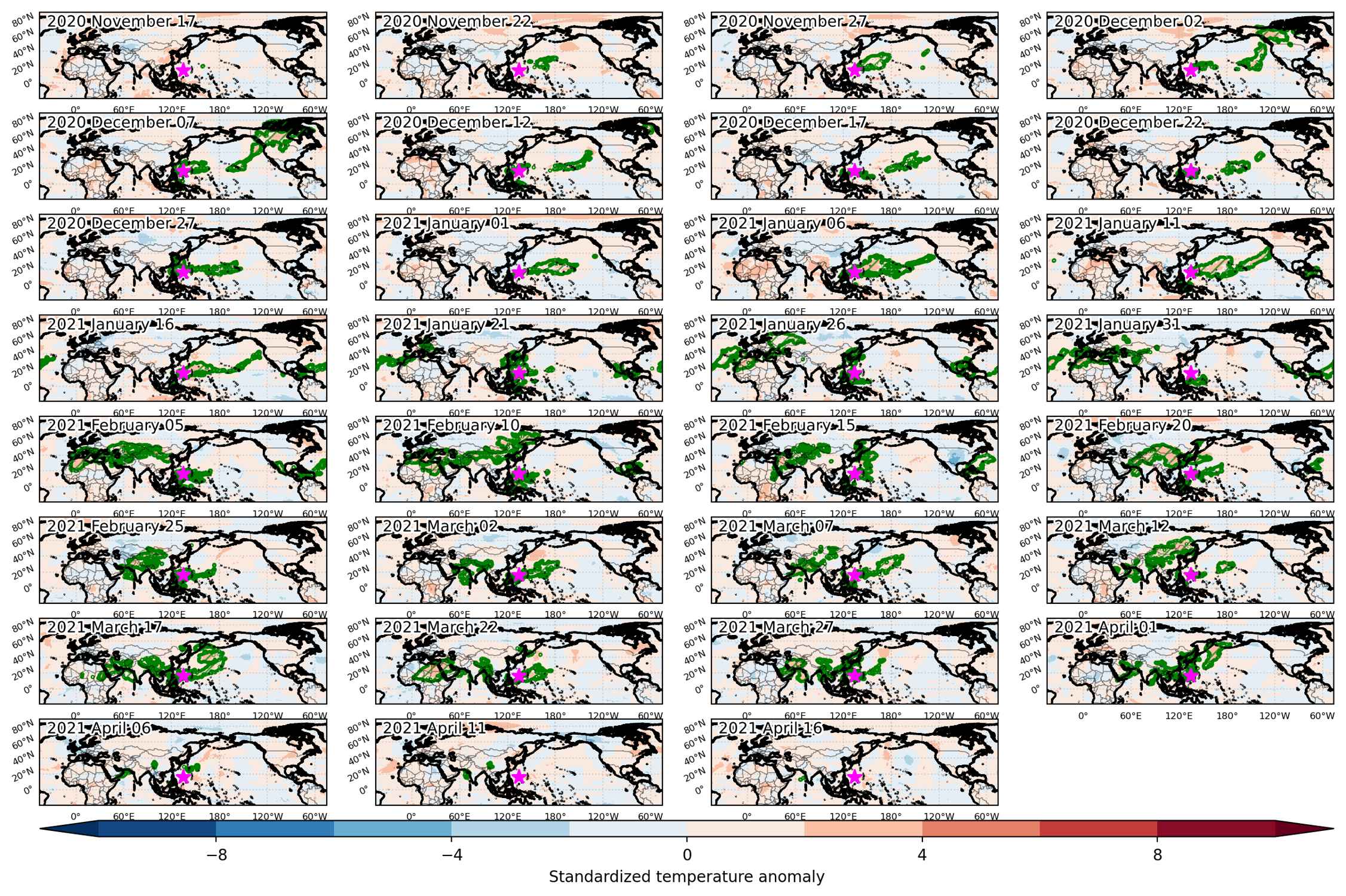
Fig. 3: Maps illustrating the evolution of standardized temperature anomalies during the event.

Event ID: Heat_wave_2020-Nov-17_to_2021-Apr-19_134.5_16.5

Heat wave occuring from October 14 2020 to February 13 2021 at 11.5°N 347.5°E

Download data: JSON

Event type: Heat wave

Countries affected (identified with ArcGIS Online; provided only for geographical reference):

  • Afghanistan
  • Albania
  • Algeria
  • Armenia
  • Azerbaijan
  • Bahrain
  • Belarus
  • Belgium
  • Benin
  • Bulgaria
  • Burkina Faso
  • Burundi
  • Cabo Verde
  • Cameroon
  • Central African Republic
  • Chad
  • China
  • Congo
  • Congo, The Democratic Republic of the
  • Cyprus
  • Czechia
  • Côte d’Ivoire
  • Egypt
  • Equatorial Guinea
  • Eritrea
  • Ethiopia
  • France
  • Gabon
  • Gambia
  • Georgia
  • Germany
  • Ghana
  • Greece
  • Guinea
  • Guinea-Bissau
  • Hungary
  • Iran, Islamic Republic of
  • Iraq
  • Israel
  • Italy
  • Jordan
  • Kazakhstan
  • Kyrgyzstan
  • Lebanon
  • Liberia
  • Libya
  • Mali
  • Mauritania
  • Moldova, Republic of
  • Mongolia
  • Morocco
  • Niger
  • Nigeria
  • North Macedonia
  • Pakistan
  • Poland
  • Portugal
  • Romania
  • Russian Federation
  • Rwanda
  • Saudi Arabia
  • Senegal
  • Serbia
  • Sierra Leone
  • Slovakia
  • South Sudan
  • Spain
  • Sudan
  • Syrian Arab Republic
  • Tajikistan
  • Tanzania, United Republic of
  • Togo
  • Tunisia
  • Turkmenistan
  • Türkiye
  • Uganda
  • Ukraine
  • United Kingdom
  • Uzbekistan

Duration: 123 days

Time span: October 14 2020 to February 13 2021

Statistics over entire affected area:

  • Mean temperature anomaly: 4.8 °C
  • Mean temperature: 18.7 °C
  • Maximum temperature anomaly: 17.0 °C
  • Maximum temperature: 32.7 °C

Event center: 3.5°N 19.5°E

Area affected: 37333109 km$^2$


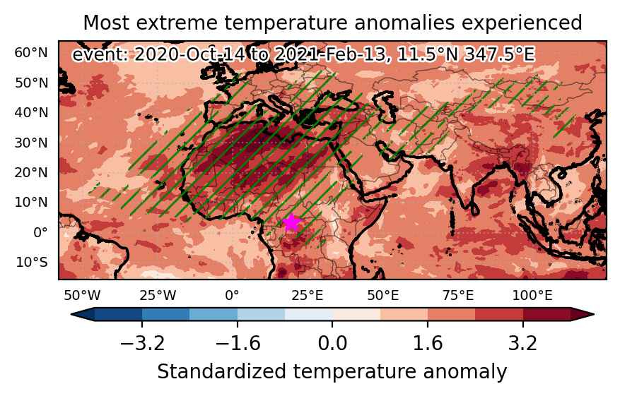
Fig. 1: Map of most extreme temperature anomalies (standardized) experienced during the event. The purple star indicates the center of the extreme event. Green hatching illustrates all areas under the effect of extremes at some time during the event.


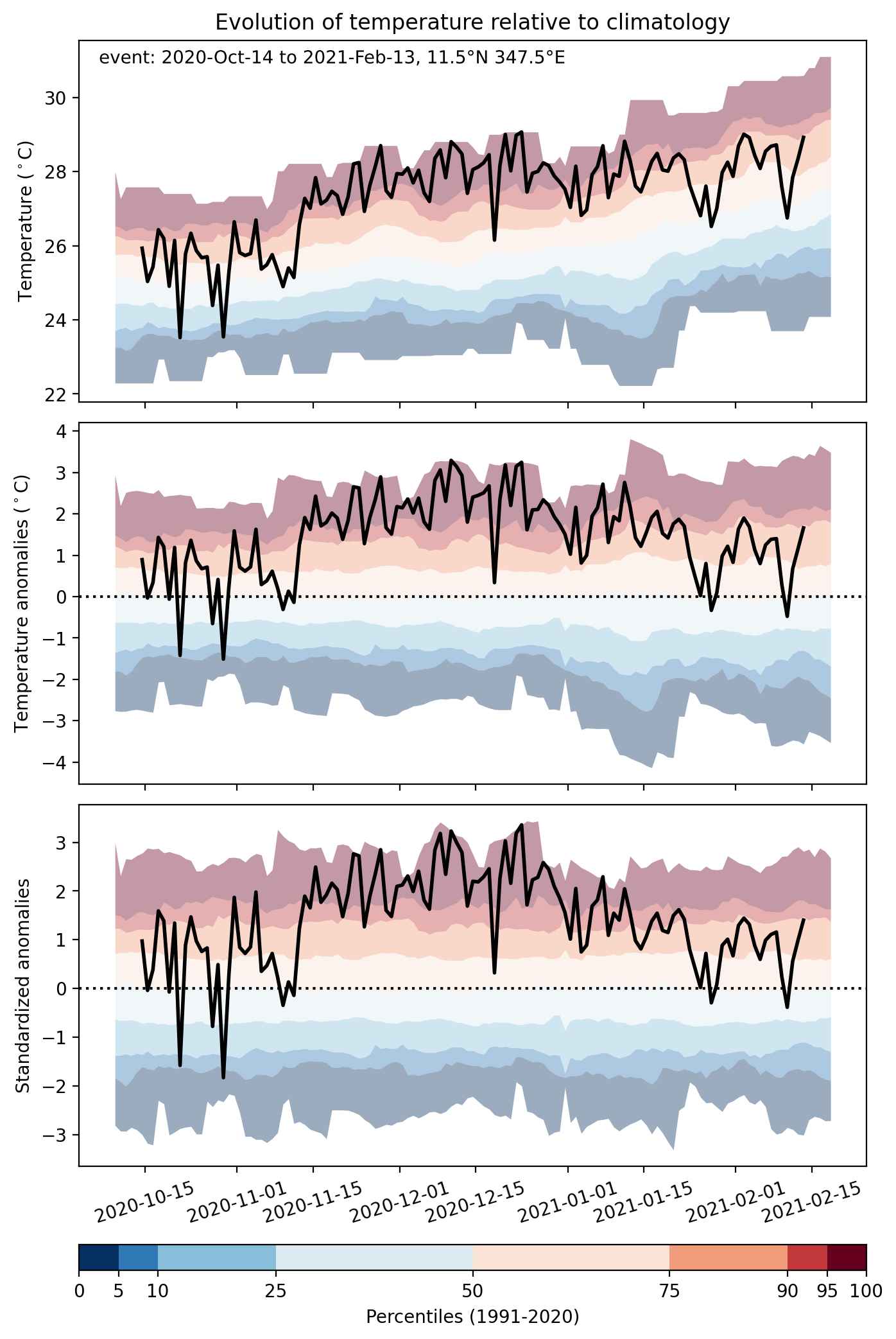
Fig. 2: Evolution of temperature at the center of the event. The climatological percentile distribution is illustrated with color shadings.


Fig. 3: Maps illustrating the evolution of standardized temperature anomalies during the event.

Event ID: Heat_wave_2020-Oct-14_to_2021-Feb-13_347.5_11.5

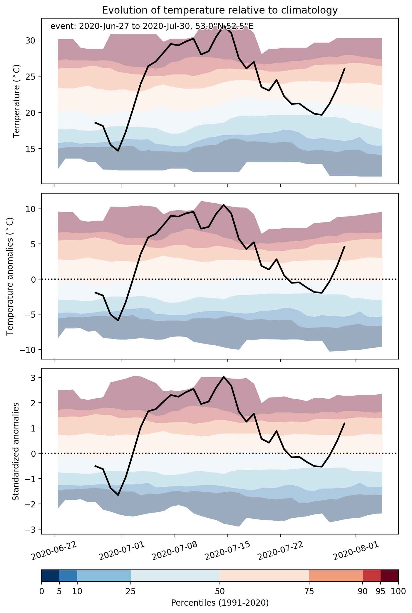
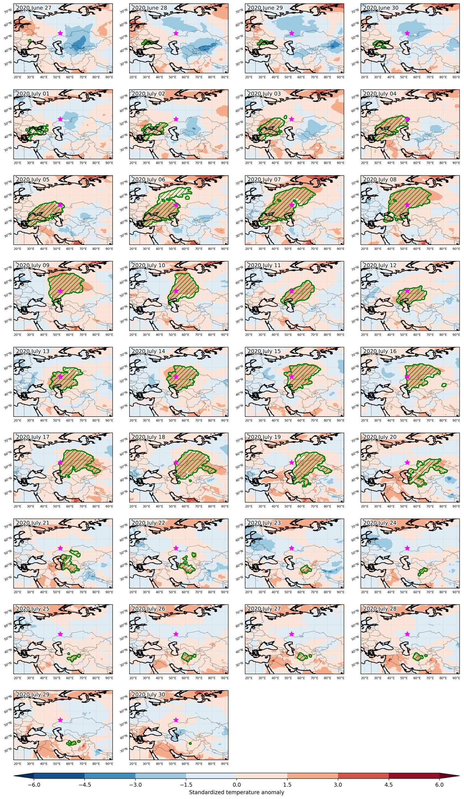
Heat wave occuring from June 27 2020 to July 30 2020 at 53.0°N 52.5°E

Download data: JSON

Event type: Heat wave

Countries affected (identified with ArcGIS Online; provided only for geographical reference):

  • Afghanistan
  • Georgia
  • Iran, Islamic Republic of
  • Kazakhstan
  • Moldova, Republic of
  • Romania
  • Russian Federation
  • Turkmenistan
  • Türkiye
  • Ukraine
  • Uzbekistan

Duration: 34 days

Time span: June 27 2020 to July 30 2020

Statistics over entire affected area:

  • Mean temperature anomaly: 6.6 °C
  • Mean temperature: 28.2 °C
  • Maximum temperature anomaly: 12.2 °C
  • Maximum temperature: 38.7 °C

Event center: 53.0°N 52.5°E

Area affected: 6539561 km$^2$


Fig. 1: Map of most extreme temperature anomalies (standardized) experienced during the event. The purple star indicates the center of the extreme event. Green hatching illustrates all areas under the effect of extremes at some time during the event.


Fig. 2: Evolution of temperature at the center of the event. The climatological percentile distribution is illustrated with color shadings.


Fig. 3: Maps illustrating the evolution of standardized temperature anomalies during the event.

Event ID: Heat_wave_2020-Jun-27_to_2020-Jul-30_52.5_53.0

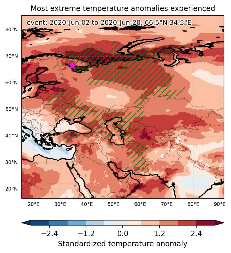
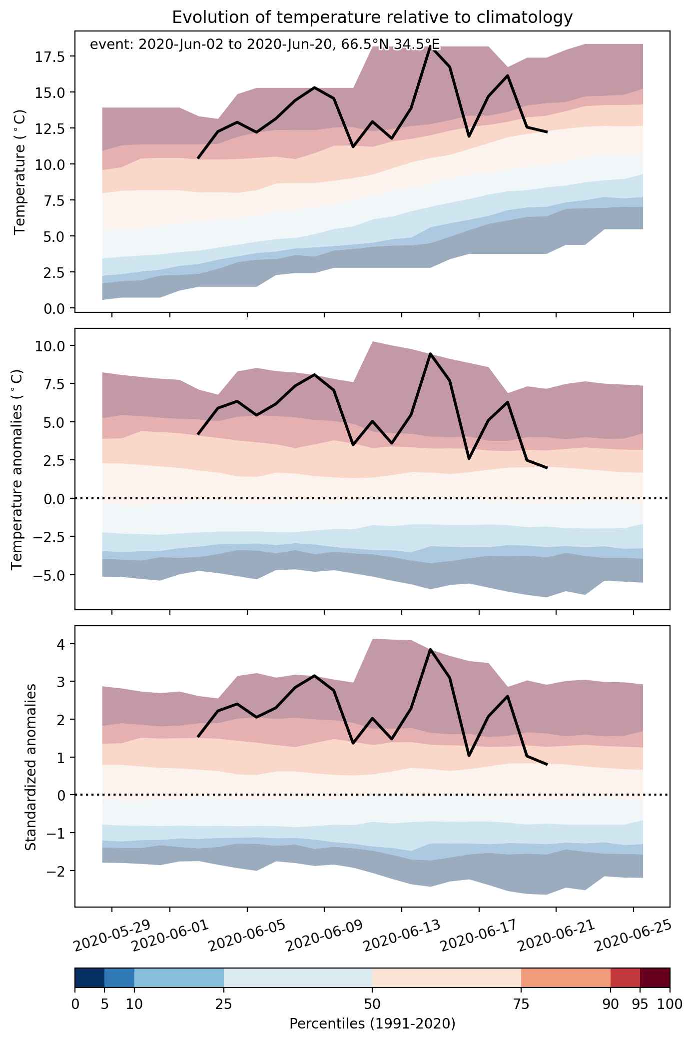
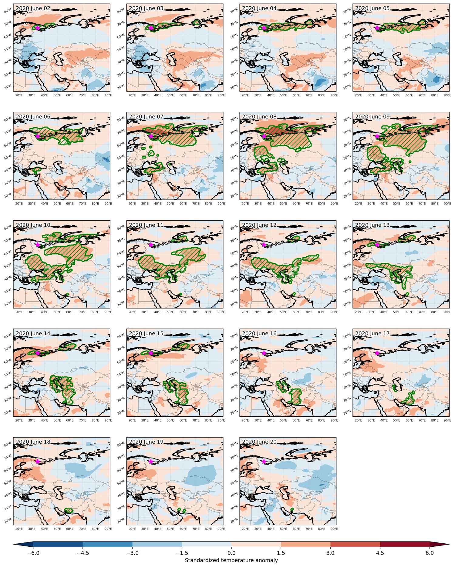
Heat wave occuring from June 02 2020 to June 20 2020 at 66.5°N 34.5°E

Download data: JSON

Event type: Heat wave

Countries affected (identified with ArcGIS Online; provided only for geographical reference):

  • Afghanistan
  • Armenia
  • Azerbaijan
  • Belarus
  • Finland
  • Georgia
  • Iran, Islamic Republic of
  • Kazakhstan
  • Latvia
  • Pakistan
  • Russian Federation
  • Turkmenistan
  • Türkiye
  • Ukraine
  • Uzbekistan

Duration: 19 days

Time span: June 02 2020 to June 20 2020

Statistics over entire affected area:

  • Mean temperature anomaly: 6.6 °C
  • Mean temperature: 19.7 °C
  • Maximum temperature anomaly: 15.2 °C
  • Maximum temperature: 42.8 °C

Event center: 66.5°N 34.5°E

Area affected: 6255277 km$^2$


Fig. 1: Map of most extreme temperature anomalies (standardized) experienced during the event. The purple star indicates the center of the extreme event. Green hatching illustrates all areas under the effect of extremes at some time during the event.


Fig. 2: Evolution of temperature at the center of the event. The climatological percentile distribution is illustrated with color shadings.


Fig. 3: Maps illustrating the evolution of standardized temperature anomalies during the event.

Event ID: Heat_wave_2020-Jun-02_to_2020-Jun-20_34.5_66.5

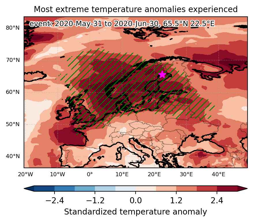
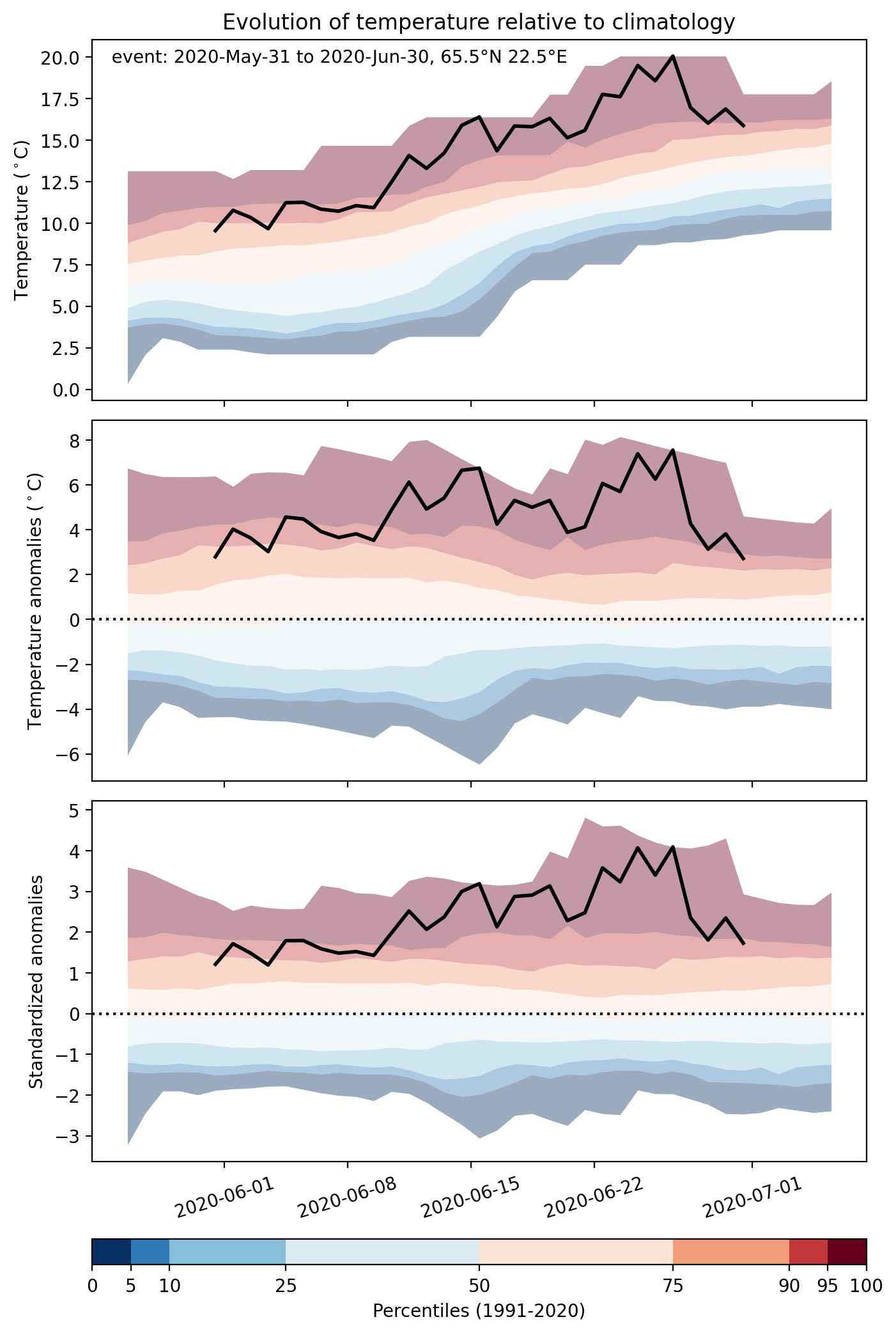
Heat wave occuring from May 31 2020 to June 30 2020 at 65.5°N 22.5°E

Download data: JSON

Event type: Heat wave

Countries affected (identified with ArcGIS Online; provided only for geographical reference):

  • Belarus
  • Belgium
  • Denmark
  • Estonia
  • Finland
  • France
  • Germany
  • Latvia
  • Lithuania
  • Netherlands
  • Norway
  • Poland
  • Russian Federation
  • Sweden
  • Ukraine
  • United Kingdom

Duration: 31 days

Time span: May 31 2020 to June 30 2020

Statistics over entire affected area:

  • Mean temperature anomaly: 4.9 °C
  • Mean temperature: 17.5 °C
  • Maximum temperature anomaly: 12.1 °C
  • Maximum temperature: 26.7 °C

Event center: 65.5°N 22.5°E

Area affected: 4562585 km$^2$


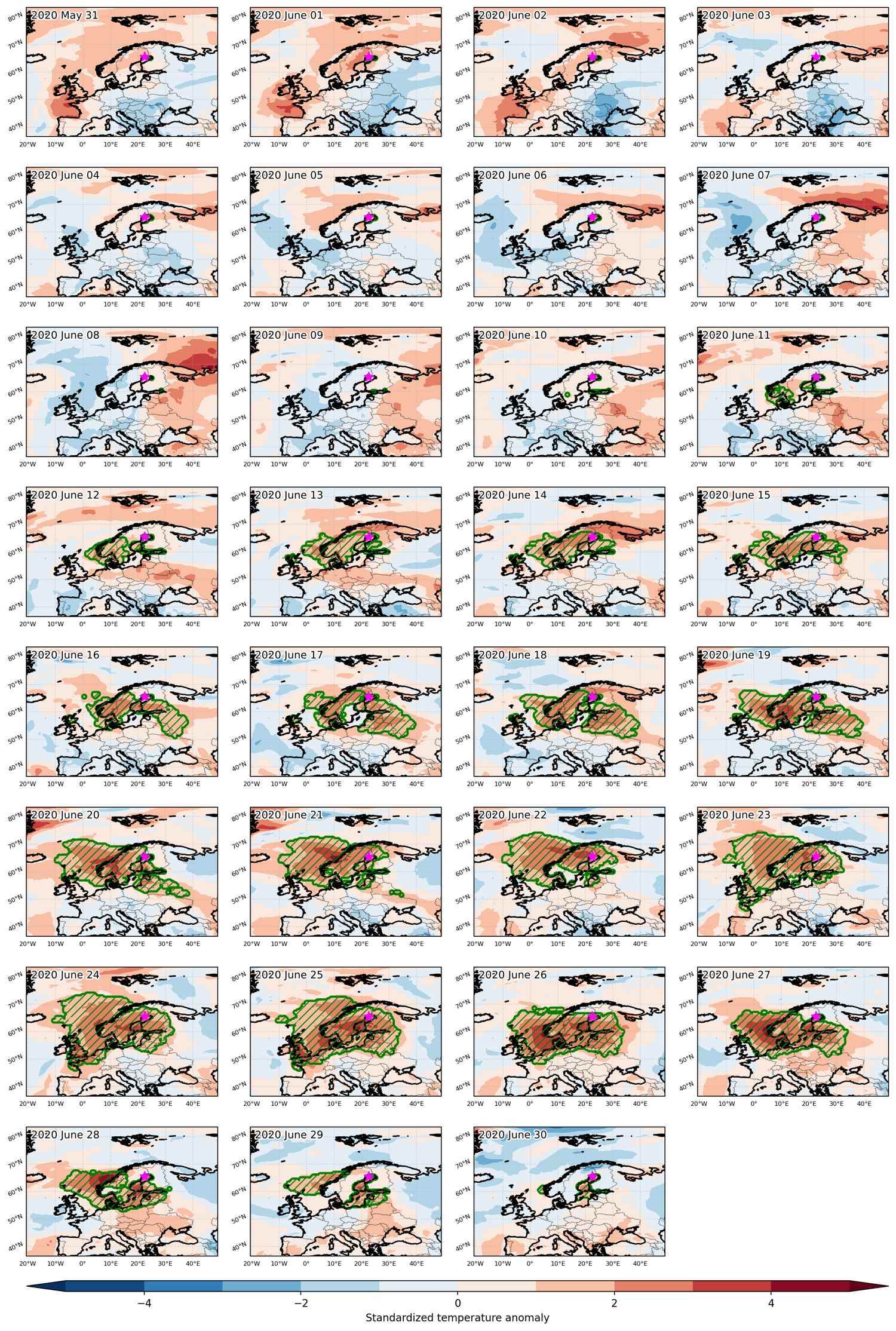
Fig. 1: Map of most extreme temperature anomalies (standardized) experienced during the event. The purple star indicates the center of the extreme event. Green hatching illustrates all areas under the effect of extremes at some time during the event.


Fig. 2: Evolution of temperature at the center of the event. The climatological percentile distribution is illustrated with color shadings.


Fig. 3: Maps illustrating the evolution of standardized temperature anomalies during the event.

Event ID: Heat_wave_2020-May-31_to_2020-Jun-30_22.5_65.5

Heat wave occuring from March 17 2020 to March 20 2020 at 49.0°N 19.5°E

Download data: JSON

Event type: Heat wave

Countries affected (identified with ArcGIS Online; provided only for geographical reference):

  • Czechia
  • Poland
  • Slovakia
  • Ukraine

Duration: 4 days

Time span: March 17 2020 to March 20 2020

Statistics over entire affected area:

  • Mean temperature anomaly: 6.8 °C
  • Mean temperature: 9.4 °C
  • Maximum temperature anomaly: 8.6 °C
  • Maximum temperature: 12.0 °C

Event center: 49.0°N 19.5°E

Area affected: 53912 km$^2$


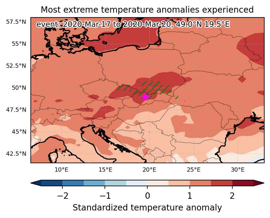
Fig. 1: Map of most extreme temperature anomalies (standardized) experienced during the event. The purple star indicates the center of the extreme event. Green hatching illustrates all areas under the effect of extremes at some time during the event.


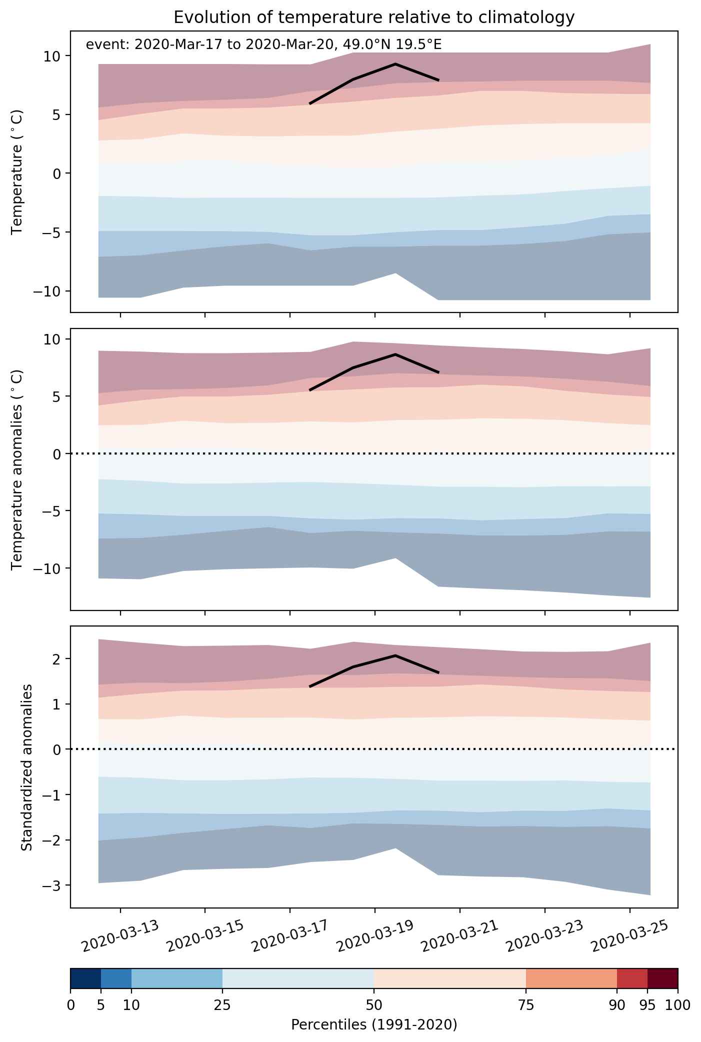
Fig. 2: Evolution of temperature at the center of the event. The climatological percentile distribution is illustrated with color shadings.


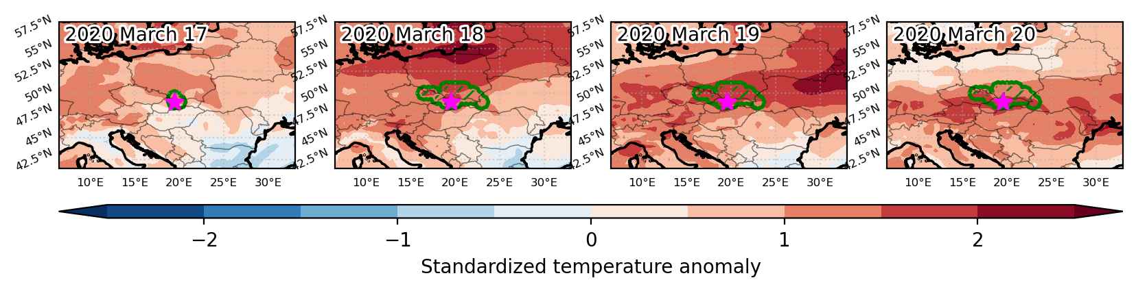
Fig. 3: Maps illustrating the evolution of standardized temperature anomalies during the event.

Event ID: Heat_wave_2020-Mar-17_to_2020-Mar-20_19.5_49.0

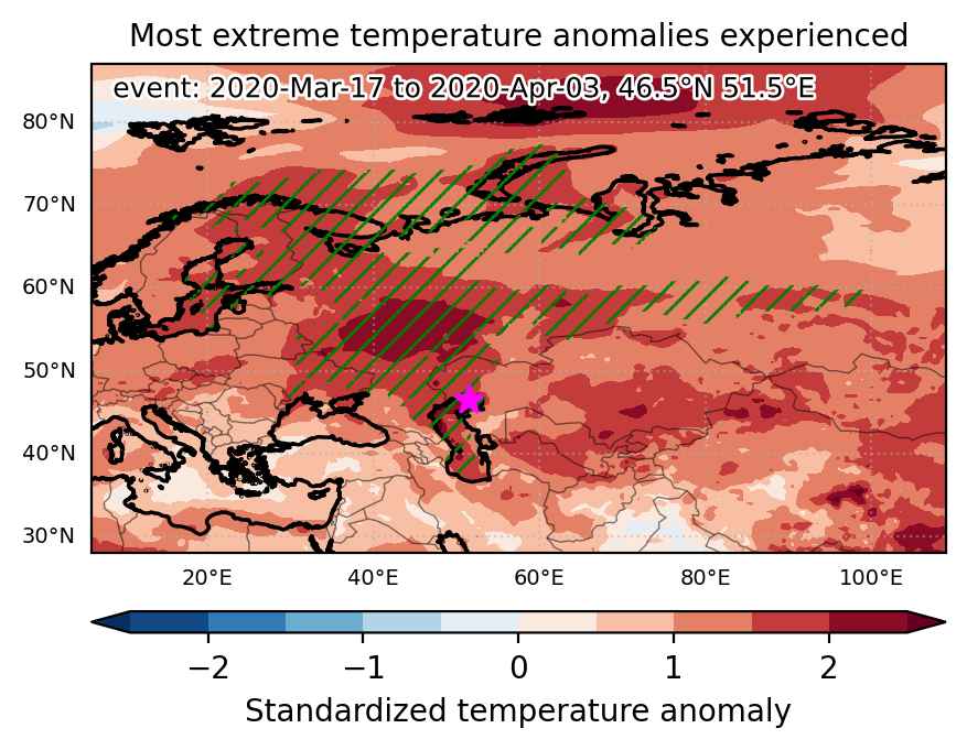
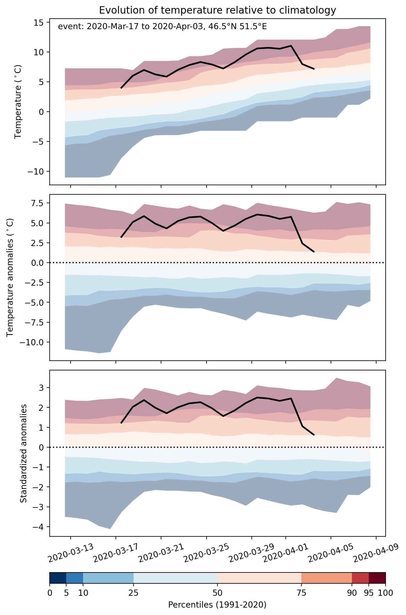
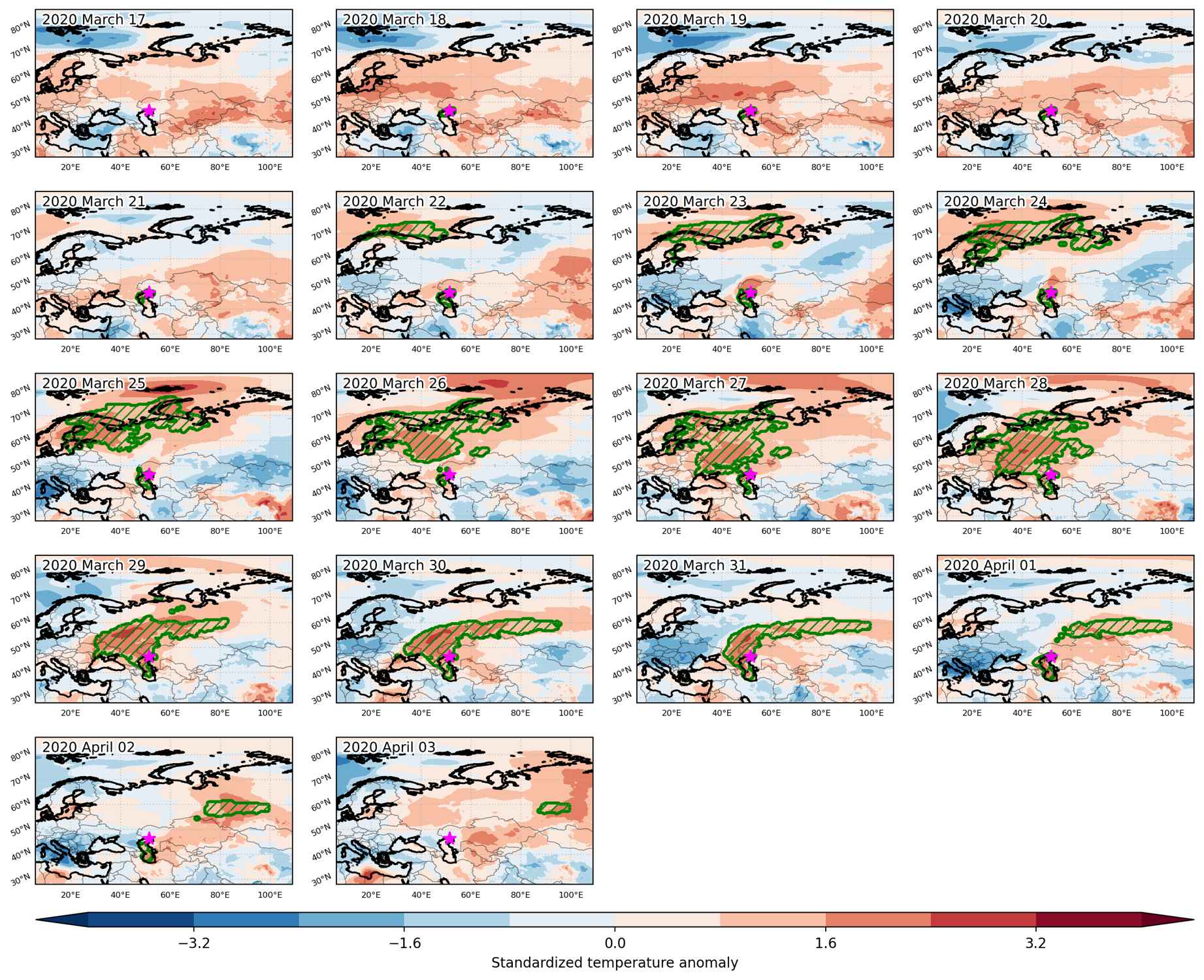
Heat wave occuring from March 17 2020 to April 03 2020 at 46.5°N 51.5°E

Download data: JSON

Event type: Heat wave

Countries affected (identified with ArcGIS Online; provided only for geographical reference):

  • Azerbaijan
  • Belarus
  • Estonia
  • Finland
  • Kazakhstan
  • Norway
  • Russian Federation
  • Sweden
  • Ukraine

Duration: 18 days

Time span: March 17 2020 to April 03 2020

Statistics over entire affected area:

  • Mean temperature anomaly: 6.9 °C
  • Mean temperature: 4.2 °C
  • Maximum temperature anomaly: 14.6 °C
  • Maximum temperature: 15.0 °C

Event center: 46.5°N 51.5°E

Area affected: 6082381 km$^2$


Fig. 1: Map of most extreme temperature anomalies (standardized) experienced during the event. The purple star indicates the center of the extreme event. Green hatching illustrates all areas under the effect of extremes at some time during the event.


Fig. 2: Evolution of temperature at the center of the event. The climatological percentile distribution is illustrated with color shadings.


Fig. 3: Maps illustrating the evolution of standardized temperature anomalies during the event.

Event ID: Heat_wave_2020-Mar-17_to_2020-Apr-03_51.5_46.5

Heat wave occuring from February 22 2020 to March 25 2020 at 44.5°N 47.5°E

Download data: JSON

Event type: Heat wave

Countries affected (identified with ArcGIS Online; provided only for geographical reference):

  • Afghanistan
  • Albania
  • Armenia
  • Azerbaijan
  • Belarus
  • Bosnia and Herzegovina
  • Bulgaria
  • China
  • Croatia
  • Denmark
  • Estonia
  • Finland
  • Georgia
  • Greece
  • Iran, Islamic Republic of
  • Iraq
  • Italy
  • Jordan
  • Kazakhstan
  • Kyrgyzstan
  • Latvia
  • Lithuania
  • Moldova, Republic of
  • Mongolia
  • Montenegro
  • North Macedonia
  • Poland
  • Romania
  • Russian Federation
  • Sweden
  • Syrian Arab Republic
  • Tajikistan
  • Turkmenistan
  • Türkiye
  • Ukraine
  • Uzbekistan

Duration: 33 days

Time span: February 22 2020 to March 25 2020

Statistics over entire affected area:

  • Mean temperature anomaly: 8.1 °C
  • Mean temperature: 5.0 °C
  • Maximum temperature anomaly: 16.0 °C
  • Maximum temperature: 23.4 °C

Event center: 44.5°N 47.5°E

Area affected: 17000898 km$^2$


Fig. 1: Map of most extreme temperature anomalies (standardized) experienced during the event. The purple star indicates the center of the extreme event. Green hatching illustrates all areas under the effect of extremes at some time during the event.


Fig. 2: Evolution of temperature at the center of the event. The climatological percentile distribution is illustrated with color shadings.


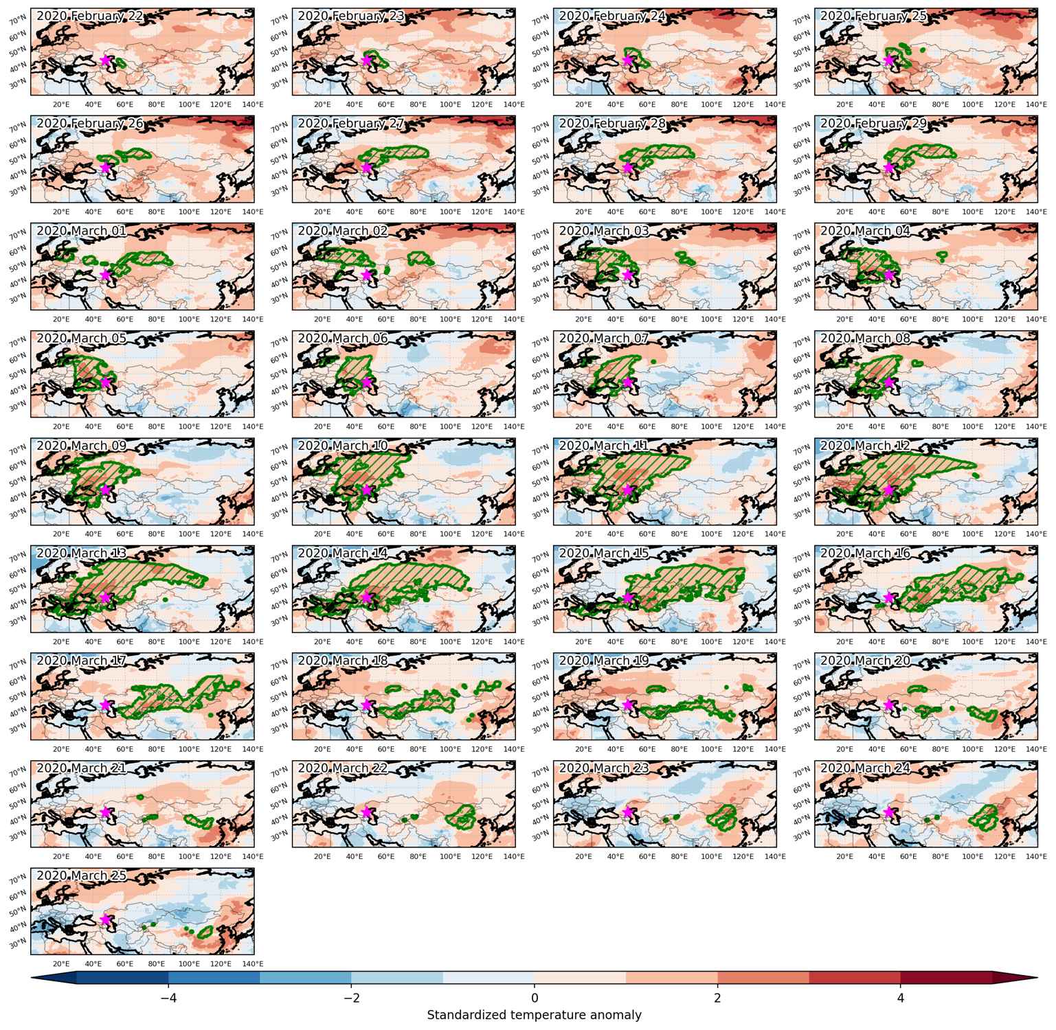
Fig. 3: Maps illustrating the evolution of standardized temperature anomalies during the event.

Event ID: Heat_wave_2020-Feb-22_to_2020-Mar-25_47.5_44.5

Heat wave occuring from February 06 2020 to March 08 2020 at 77.0°N 95.5°E

Download data: JSON

Event type: Heat wave

Countries affected (identified with ArcGIS Online; provided only for geographical reference):

  • Andorra
  • Austria
  • Belarus
  • Belgium
  • Bosnia and Herzegovina
  • Canada
  • Croatia
  • Czechia
  • Denmark
  • Estonia
  • Finland
  • France
  • Germany
  • Greece
  • Hungary
  • Italy
  • Kazakhstan
  • Latvia
  • Lithuania
  • Luxembourg
  • Moldova, Republic of
  • Montenegro
  • Netherlands
  • Norway
  • Poland
  • Romania
  • Russian Federation
  • Slovakia
  • Slovenia
  • Spain
  • Sweden
  • Switzerland
  • Tunisia
  • Ukraine

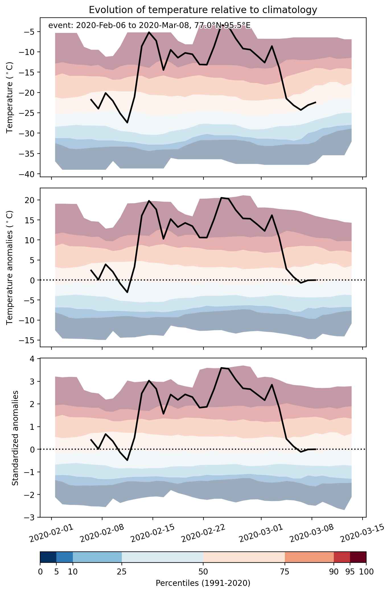
Duration: 32 days

Time span: February 06 2020 to March 08 2020

Statistics over entire affected area:

  • Mean temperature anomaly: 12.2 °C
  • Mean temperature: -8.9 °C
  • Maximum temperature anomaly: 27.9 °C
  • Maximum temperature: 17.1 °C

Event center: 77.0°N 95.5°E

Area affected: 18911486 km$^2$


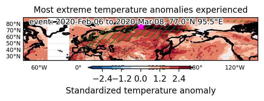
Fig. 1: Map of most extreme temperature anomalies (standardized) experienced during the event. The purple star indicates the center of the extreme event. Green hatching illustrates all areas under the effect of extremes at some time during the event.


Fig. 2: Evolution of temperature at the center of the event. The climatological percentile distribution is illustrated with color shadings.


Fig. 3: Maps illustrating the evolution of standardized temperature anomalies during the event.

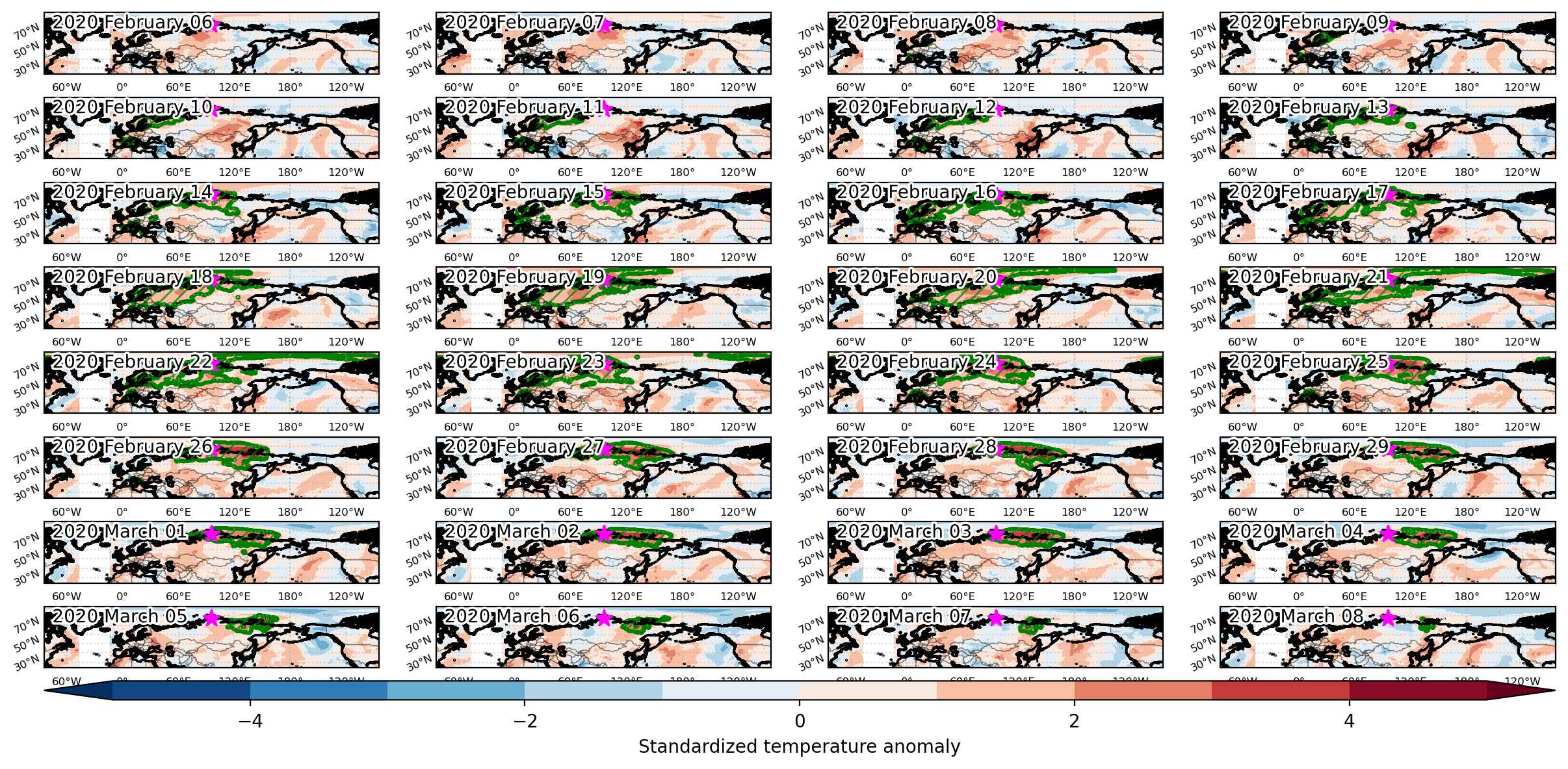
Event ID: Heat_wave_2020-Feb-06_to_2020-Mar-08_95.5_77.0