Cold spell occuring from December 14 2014 to December 19 2014 at -16.5°S 321.0°E

Download data: JSON

Event type: Cold spell

Countries affected (identified with ArcGIS Online; provided only for geographical reference):

  • Brazil

Duration: 6 days

Time span: December 14 2014 to December 19 2014

Statistics over entire affected area:

  • Mean temperature anomaly: -1.6 °C
  • Mean temperature: 24.1 °C
  • Minimum temperature anomaly: -3.6 °C
  • Minimum temperature: 20.4 °C

Event center: -16.5°S 321.0°E

Area affected: 308001 km$^2$
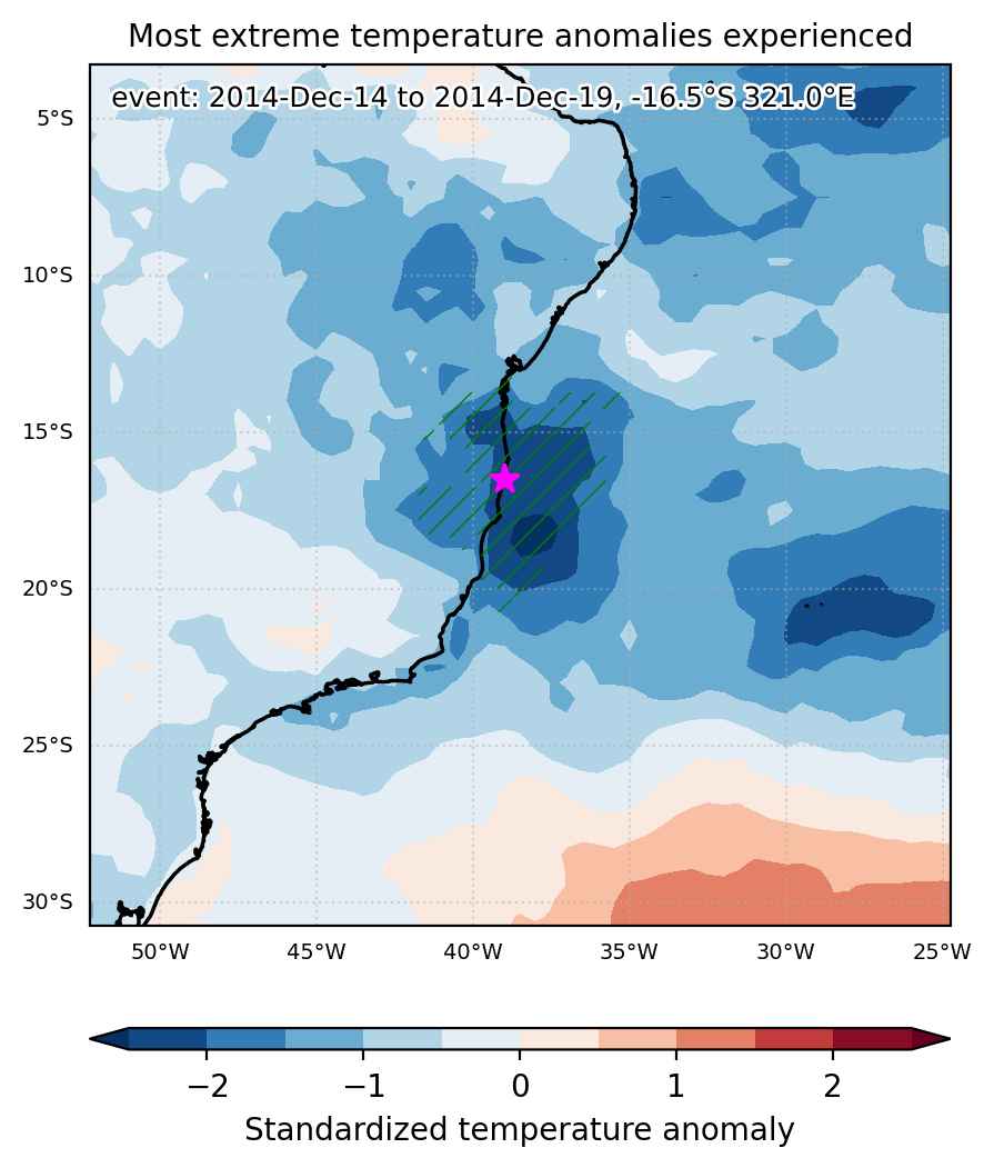

Fig. 1: Map of most extreme temperature anomalies (standardized) experienced during the event. The purple star indicates the center of the extreme event. Green hatching illustrates all areas under the effect of extremes at some time during the event.
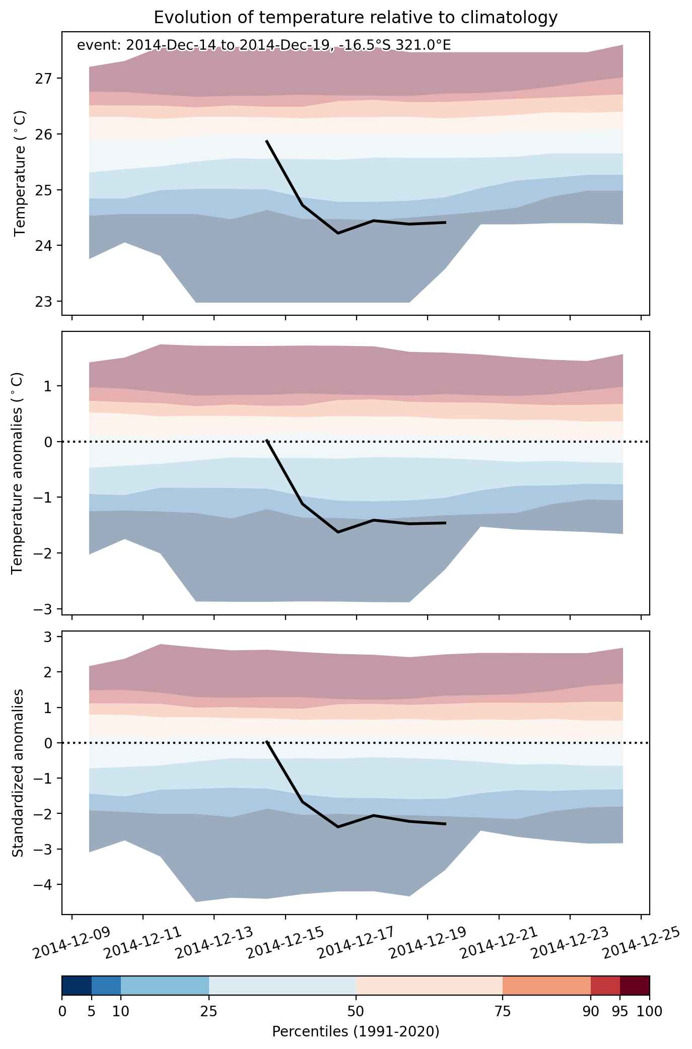


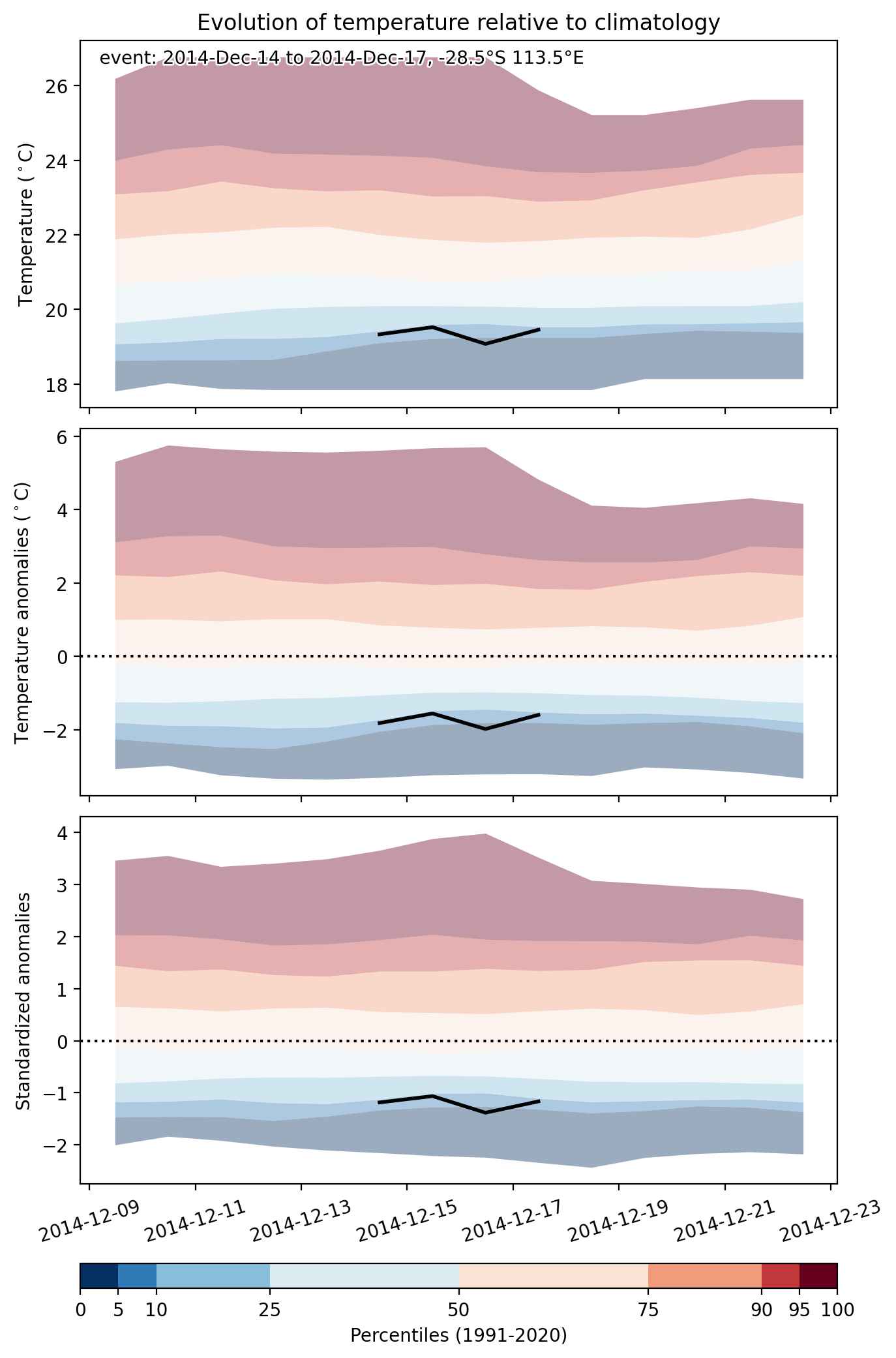
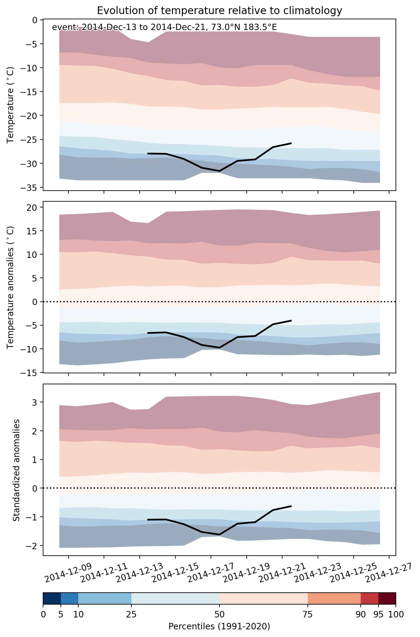
Fig. 2: Evolution of temperature at the center of the event. The climatological percentile distribution is illustrated with color shadings.
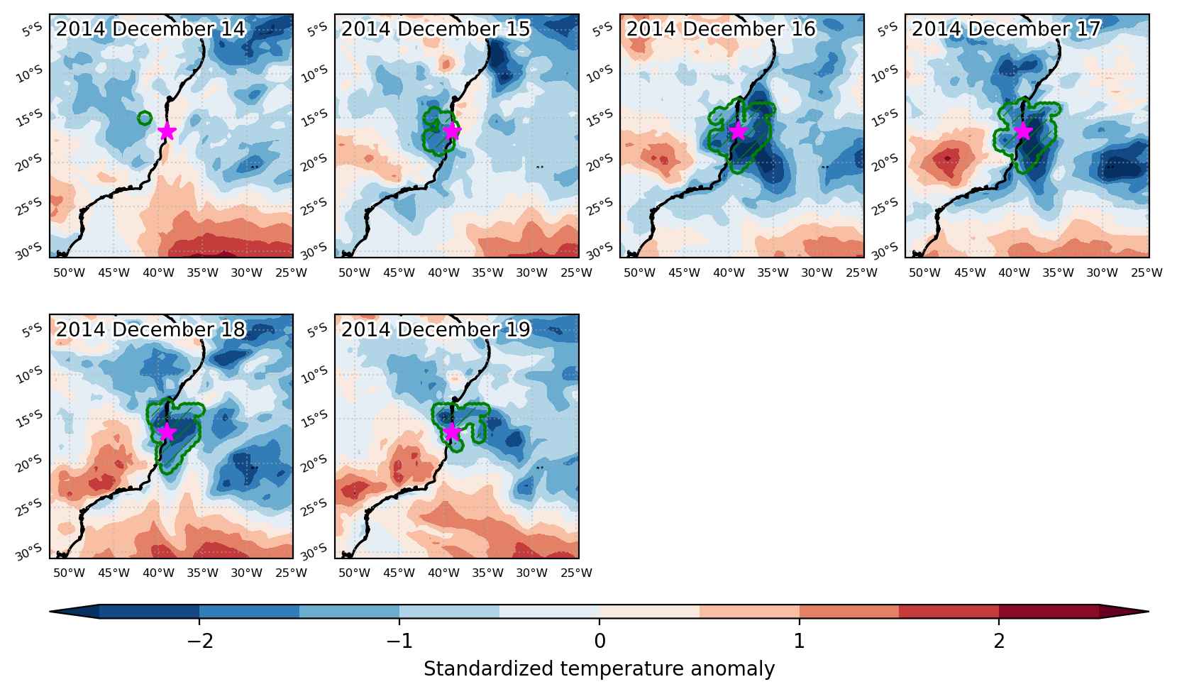


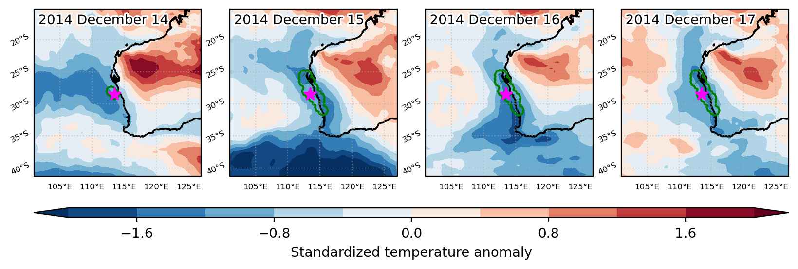
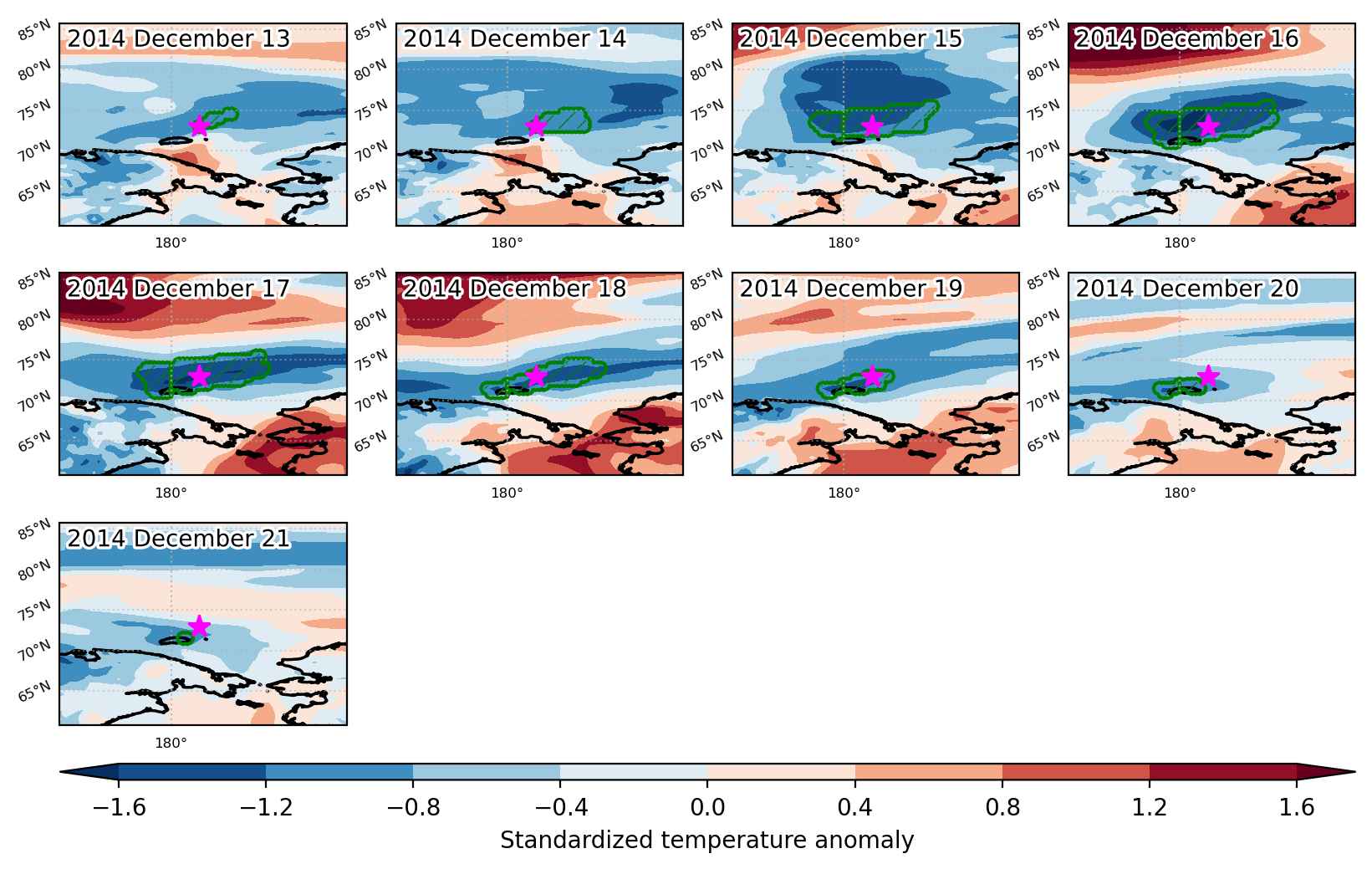
Fig. 3: Maps illustrating the evolution of standardized temperature anomalies during the event.

Event ID: Cold_spell_2014-Dec-14_to_2014-Dec-19_321.0_-16.5
Cold spell occuring from December 14 2014 to December 17 2014 at -28.5°S 113.5°E

Download data: JSON

Event type: Cold spell

Countries affected (identified with ArcGIS Online; provided only for geographical reference):

  • Australia

Duration: 4 days

Time span: December 14 2014 to December 17 2014

Statistics over entire affected area:

  • Mean temperature anomaly: -2.2 °C
  • Mean temperature: 19.6 °C
  • Minimum temperature anomaly: -4.8 °C
  • Minimum temperature: 18.4 °C

Event center: -28.5°S 113.5°E

Area affected: 68245 km$^2$


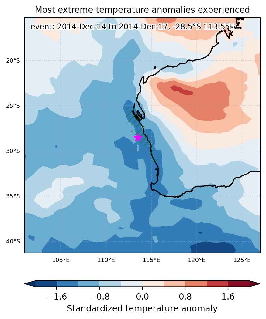
Fig. 1: Map of most extreme temperature anomalies (standardized) experienced during the event. The purple star indicates the center of the extreme event. Green hatching illustrates all areas under the effect of extremes at some time during the event.


Fig. 2: Evolution of temperature at the center of the event. The climatological percentile distribution is illustrated with color shadings.


Fig. 3: Maps illustrating the evolution of standardized temperature anomalies during the event.

Event ID: Cold_spell_2014-Dec-14_to_2014-Dec-17_113.5_-28.5

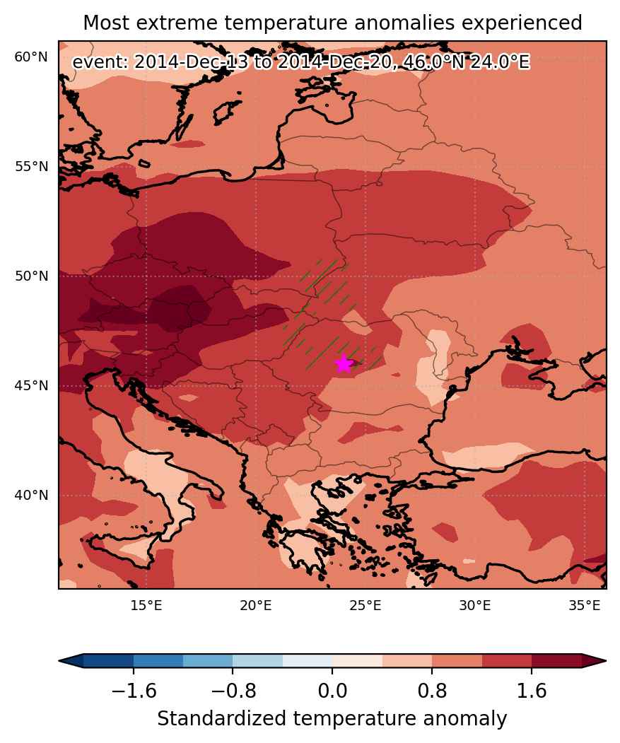
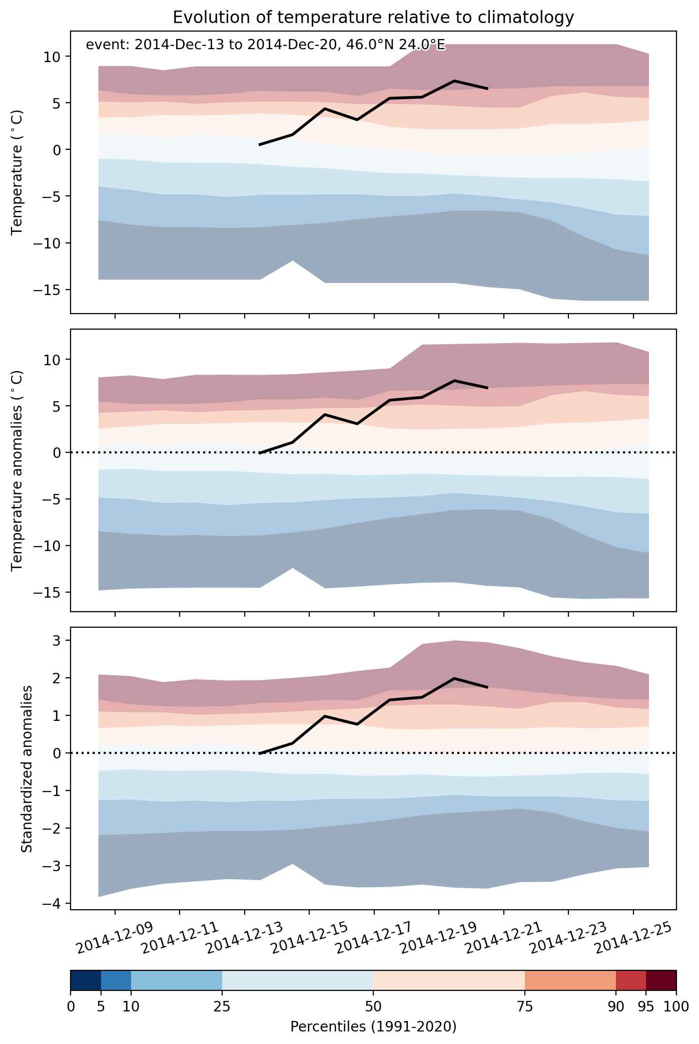
Heat wave occuring from December 13 2014 to December 20 2014 at 46.0°N 24.0°E

Download data: JSON

Event type: Heat wave

Countries affected (identified with ArcGIS Online; provided only for geographical reference):

  • Hungary
  • Poland
  • Romania
  • Slovakia
  • Ukraine

Duration: 8 days

Time span: December 13 2014 to December 20 2014

Statistics over entire affected area:

  • Mean temperature anomaly: 6.3 °C
  • Mean temperature: 5.4 °C
  • Maximum temperature anomaly: 8.4 °C
  • Maximum temperature: 7.8 °C

Event center: 46.0°N 24.0°E

Area affected: 68169 km$^2$


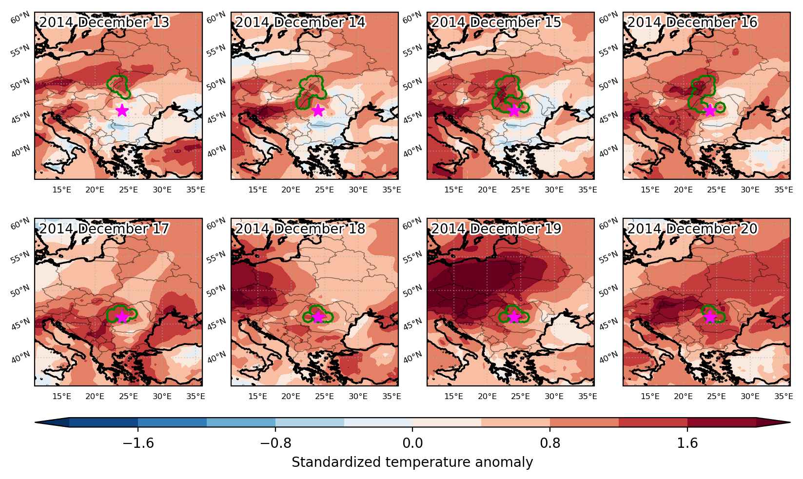
Fig. 1: Map of most extreme temperature anomalies (standardized) experienced during the event. The purple star indicates the center of the extreme event. Green hatching illustrates all areas under the effect of extremes at some time during the event.


Fig. 2: Evolution of temperature at the center of the event. The climatological percentile distribution is illustrated with color shadings.


Fig. 3: Maps illustrating the evolution of standardized temperature anomalies during the event.

Event ID: Heat_wave_2014-Dec-13_to_2014-Dec-20_24.0_46.0

Heat wave occuring from December 13 2014 to December 15 2014 at 41.0°N 10.5°E

Download data: JSON

Event type: Heat wave

Countries affected (identified with ArcGIS Online; provided only for geographical reference):

  • Italy

Duration: 3 days

Time span: December 13 2014 to December 15 2014

Statistics over entire affected area:

  • Mean temperature anomaly: 2.8 °C
  • Mean temperature: 16.0 °C
  • Maximum temperature anomaly: 3.7 °C
  • Maximum temperature: 17.0 °C

Event center: 41.0°N 10.5°E

Area affected: 57815 km$^2$


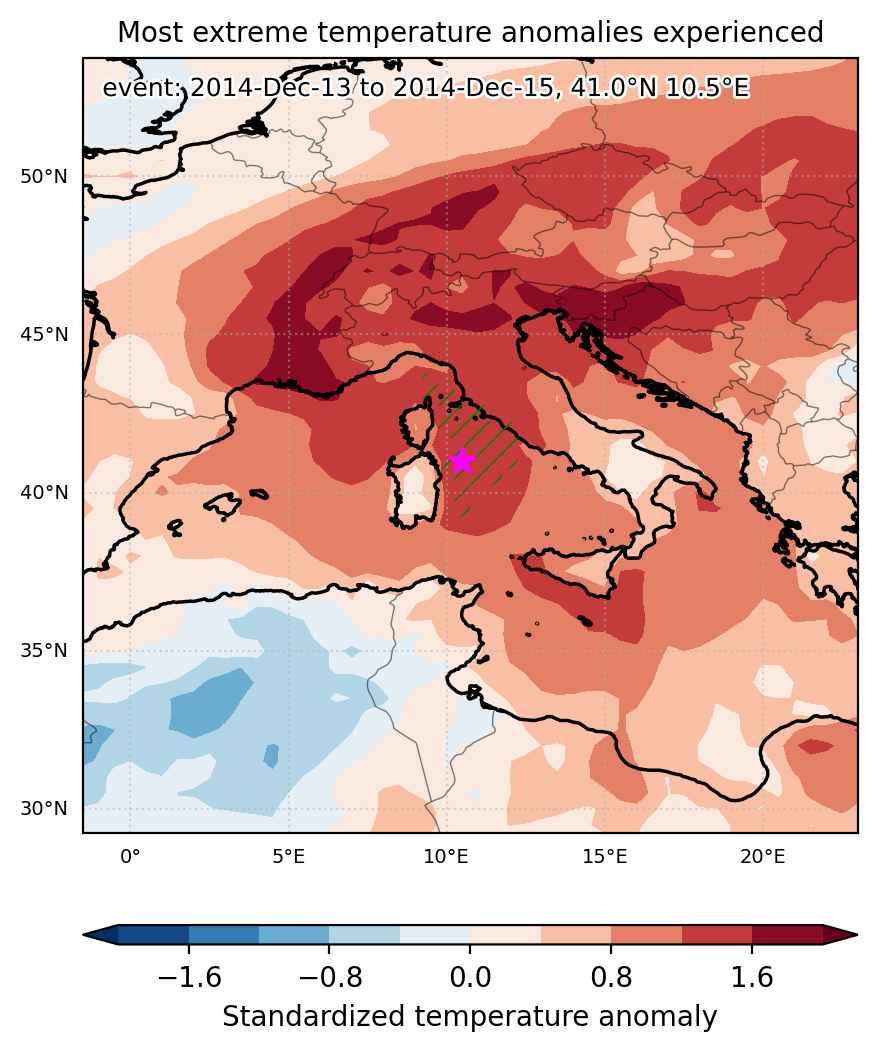
Fig. 1: Map of most extreme temperature anomalies (standardized) experienced during the event. The purple star indicates the center of the extreme event. Green hatching illustrates all areas under the effect of extremes at some time during the event.


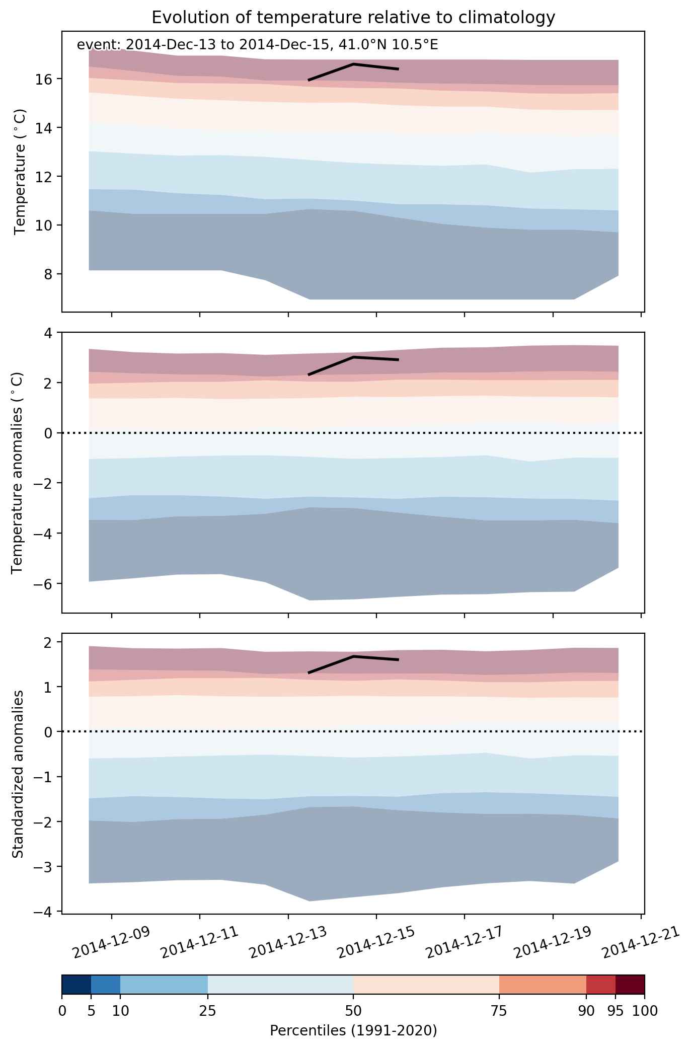
Fig. 2: Evolution of temperature at the center of the event. The climatological percentile distribution is illustrated with color shadings.


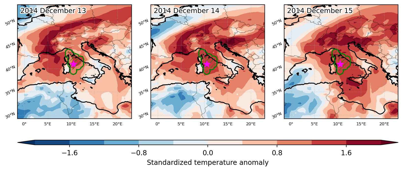
Fig. 3: Maps illustrating the evolution of standardized temperature anomalies during the event.

Event ID: Heat_wave_2014-Dec-13_to_2014-Dec-15_10.5_41.0

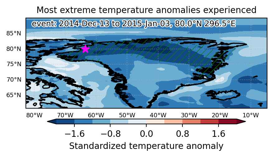
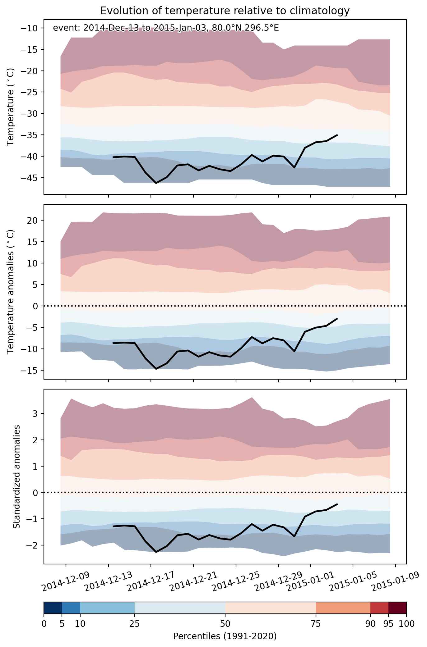
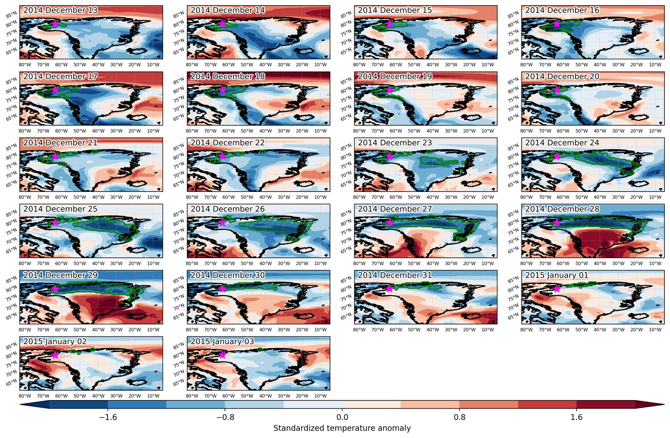
Cold spell occuring from December 13 2014 to January 03 2015 at 80.0°N 296.5°E

Download data: JSON

Event type: Cold spell

Countries affected (identified with ArcGIS Online; provided only for geographical reference):

  • Canada
  • Greenland

Duration: 22 days

Time span: December 13 2014 to January 03 2015

Statistics over entire affected area:

  • Mean temperature anomaly: -9.4 °C
  • Mean temperature: -39.7 °C
  • Minimum temperature anomaly: -16.2 °C
  • Minimum temperature: -51.0 °C

Event center: 80.0°N 296.5°E

Area affected: 748611 km$^2$


Fig. 1: Map of most extreme temperature anomalies (standardized) experienced during the event. The purple star indicates the center of the extreme event. Green hatching illustrates all areas under the effect of extremes at some time during the event.


Fig. 2: Evolution of temperature at the center of the event. The climatological percentile distribution is illustrated with color shadings.


Fig. 3: Maps illustrating the evolution of standardized temperature anomalies during the event.

Event ID: Cold_spell_2014-Dec-13_to_2015-Jan-03_296.5_80.0

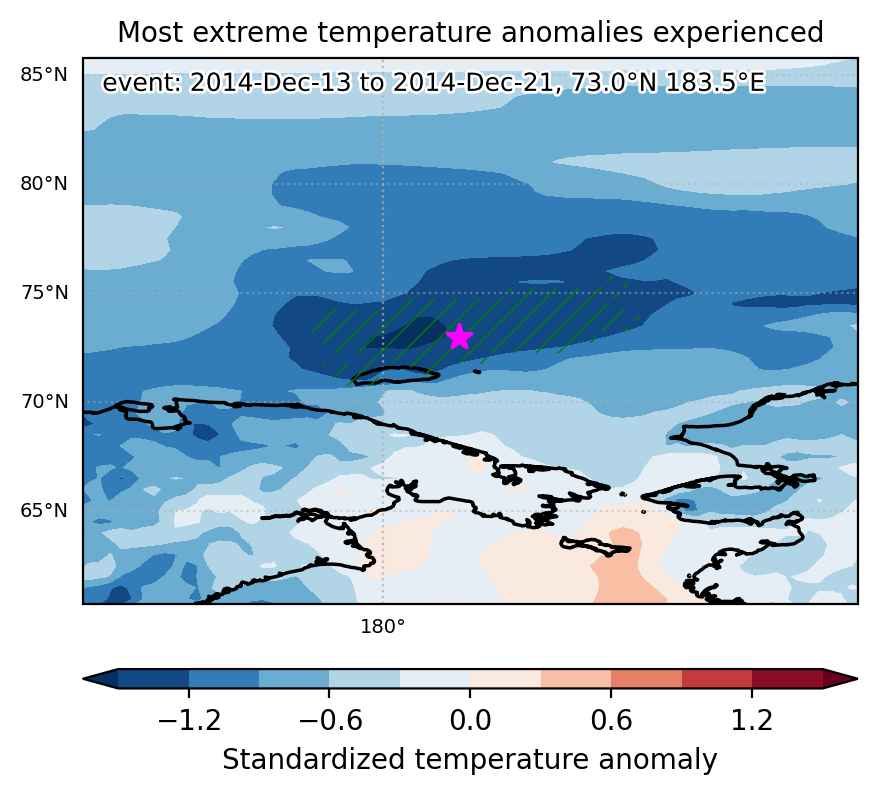
Cold spell occuring from December 13 2014 to December 21 2014 at 73.0°N 183.5°E

Download data: JSON

Event type: Cold spell

Countries affected (identified with ArcGIS Online; provided only for geographical reference):

  • Russian Federation

Duration: 9 days

Time span: December 13 2014 to December 21 2014

Statistics over entire affected area:

  • Mean temperature anomaly: -7.9 °C
  • Mean temperature: -29.9 °C
  • Minimum temperature anomaly: -10.7 °C
  • Minimum temperature: -33.0 °C

Event center: 73.0°N 183.5°E

Area affected: 144396 km$^2$


Fig. 1: Map of most extreme temperature anomalies (standardized) experienced during the event. The purple star indicates the center of the extreme event. Green hatching illustrates all areas under the effect of extremes at some time during the event.


Fig. 2: Evolution of temperature at the center of the event. The climatological percentile distribution is illustrated with color shadings.


Fig. 3: Maps illustrating the evolution of standardized temperature anomalies during the event.

Event ID: Cold_spell_2014-Dec-13_to_2014-Dec-21_183.5_73.0

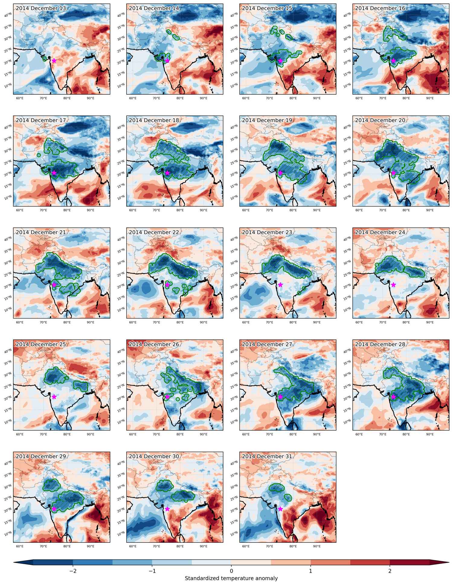
Cold spell occuring from December 13 2014 to December 31 2014 at 20.5°N 74.5°E

Download data: JSON

Event type: Cold spell

Countries affected (identified with ArcGIS Online; provided only for geographical reference):

  • India
  • Nepal
  • Pakistan

Duration: 19 days

Time span: December 13 2014 to December 31 2014

Statistics over entire affected area:

  • Mean temperature anomaly: -3.3 °C
  • Mean temperature: 12.7 °C
  • Minimum temperature anomaly: -11.9 °C
  • Minimum temperature: -17.9 °C

Event center: 20.5°N 74.5°E

Area affected: 1889693 km$^2$


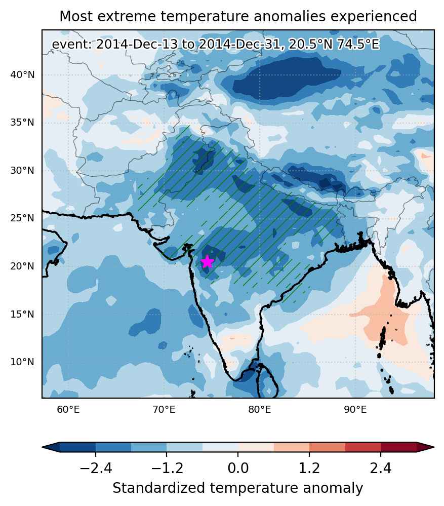
Fig. 1: Map of most extreme temperature anomalies (standardized) experienced during the event. The purple star indicates the center of the extreme event. Green hatching illustrates all areas under the effect of extremes at some time during the event.


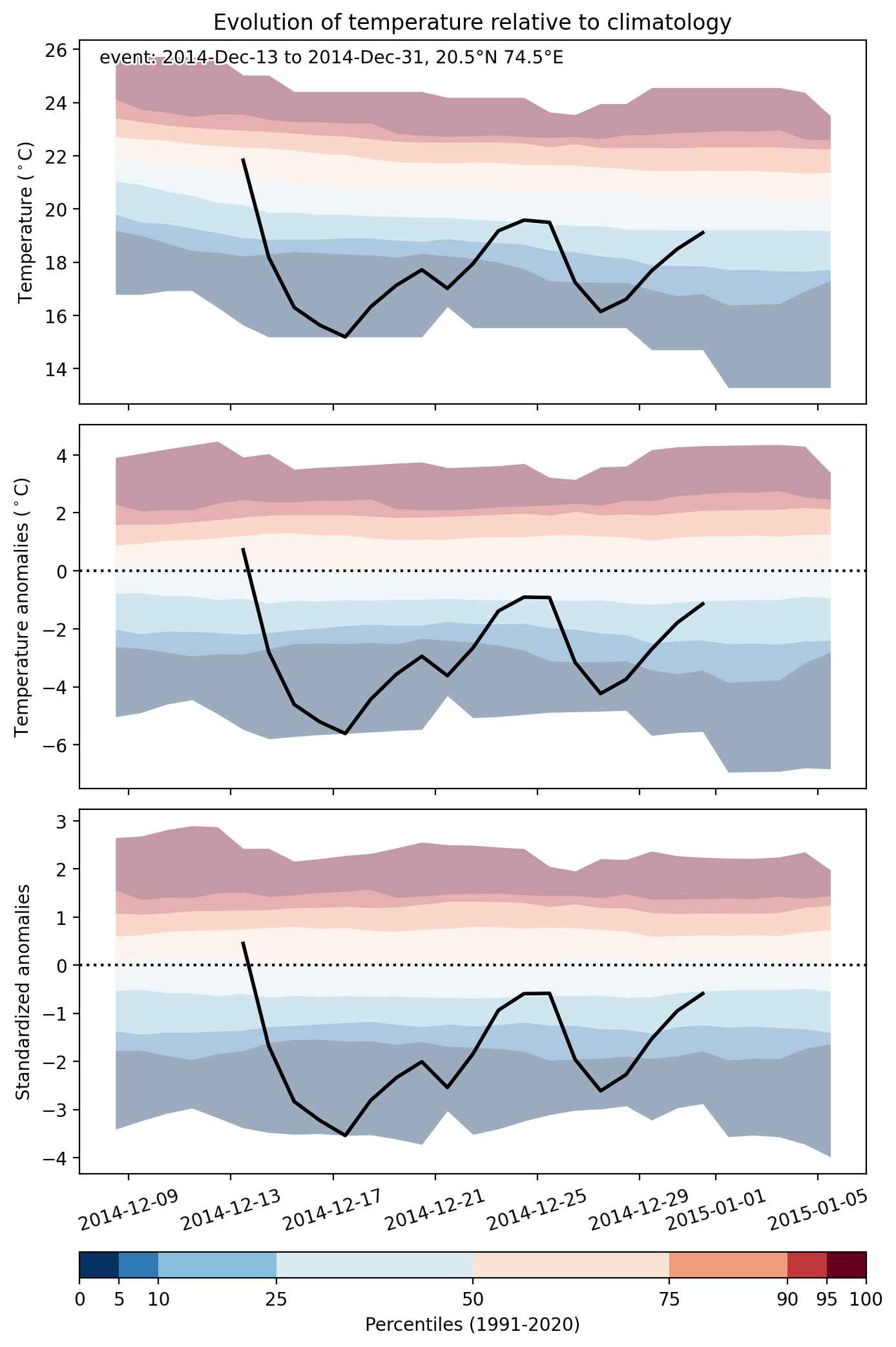
Fig. 2: Evolution of temperature at the center of the event. The climatological percentile distribution is illustrated with color shadings.


Fig. 3: Maps illustrating the evolution of standardized temperature anomalies during the event.

Event ID: Cold_spell_2014-Dec-13_to_2014-Dec-31_74.5_20.5

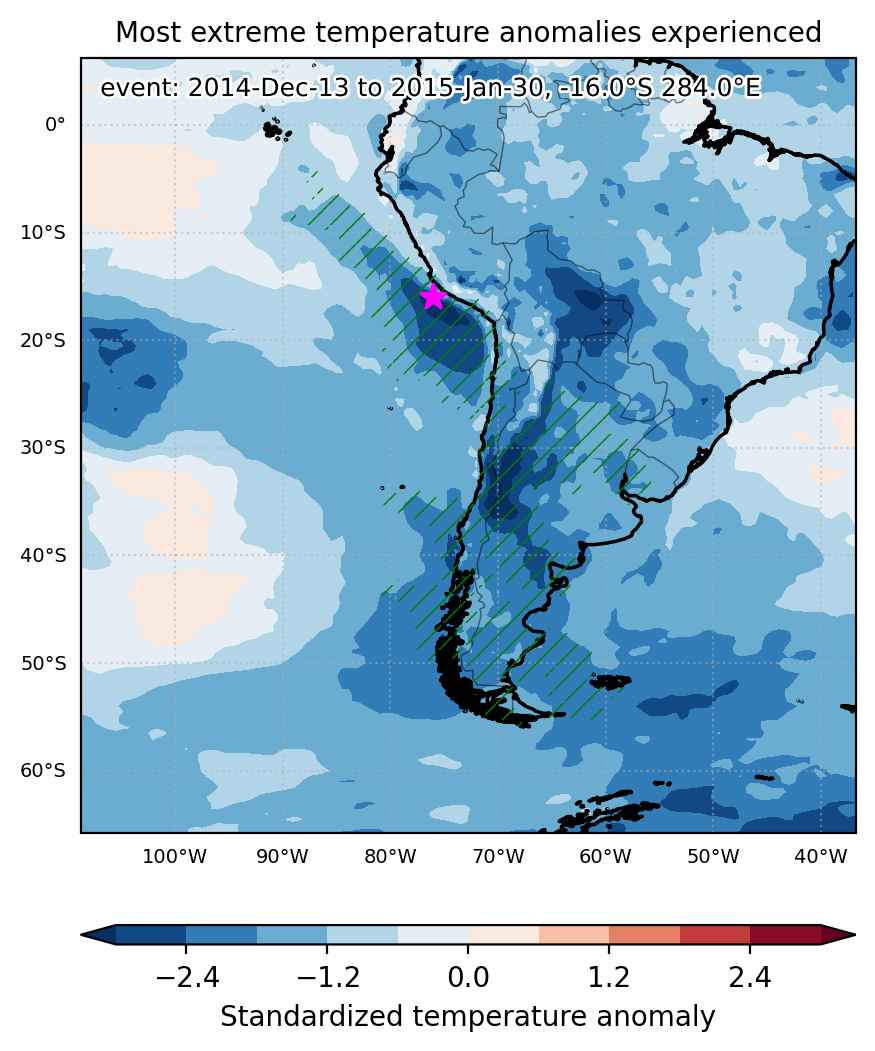
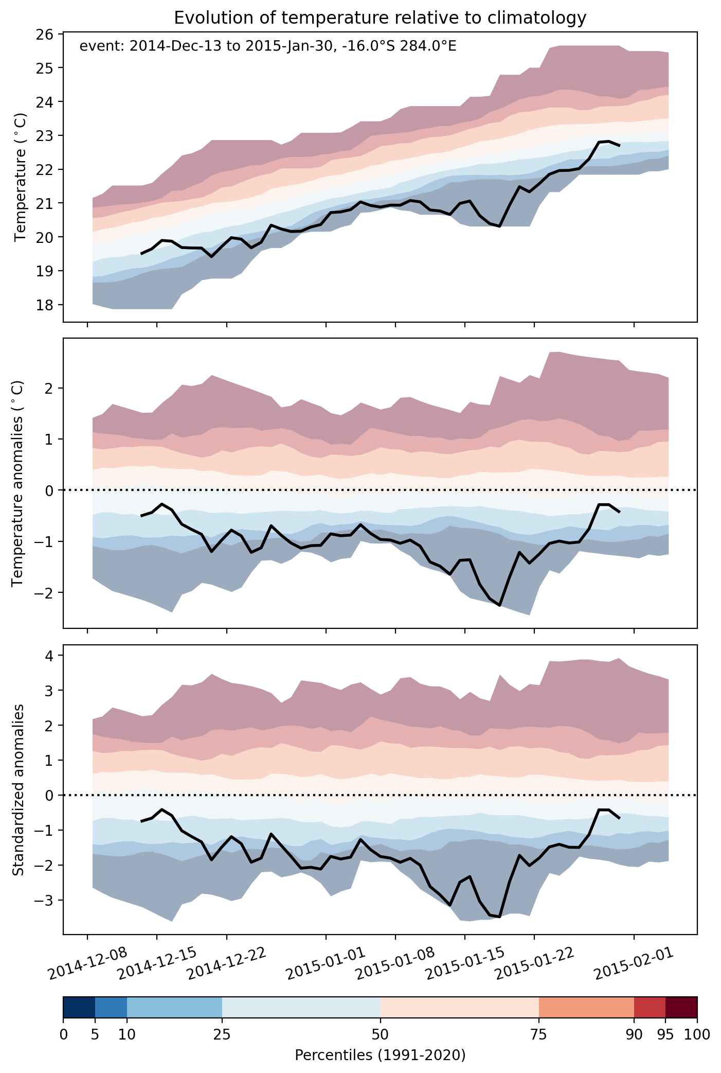
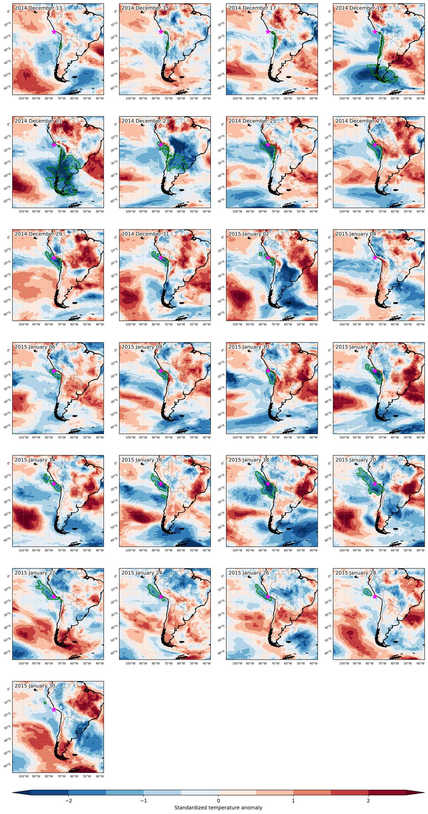
Cold spell occuring from December 13 2014 to January 30 2015 at -16.0°S 284.0°E

Download data: JSON

Event type: Cold spell

Countries affected (identified with ArcGIS Online; provided only for geographical reference):

  • Argentina
  • Chile
  • Peru
  • Uruguay

Duration: 49 days

Time span: December 13 2014 to January 30 2015

Statistics over entire affected area:

  • Mean temperature anomaly: -2.6 °C
  • Mean temperature: 17.1 °C
  • Minimum temperature anomaly: -14.2 °C
  • Minimum temperature: -11.4 °C

Event center: -16.0°S 284.0°E

Area affected: 4820276 km$^2$


Fig. 1: Map of most extreme temperature anomalies (standardized) experienced during the event. The purple star indicates the center of the extreme event. Green hatching illustrates all areas under the effect of extremes at some time during the event.


Fig. 2: Evolution of temperature at the center of the event. The climatological percentile distribution is illustrated with color shadings.


Fig. 3: Maps illustrating the evolution of standardized temperature anomalies during the event.

Event ID: Cold_spell_2014-Dec-13_to_2015-Jan-30_284.0_-16.0

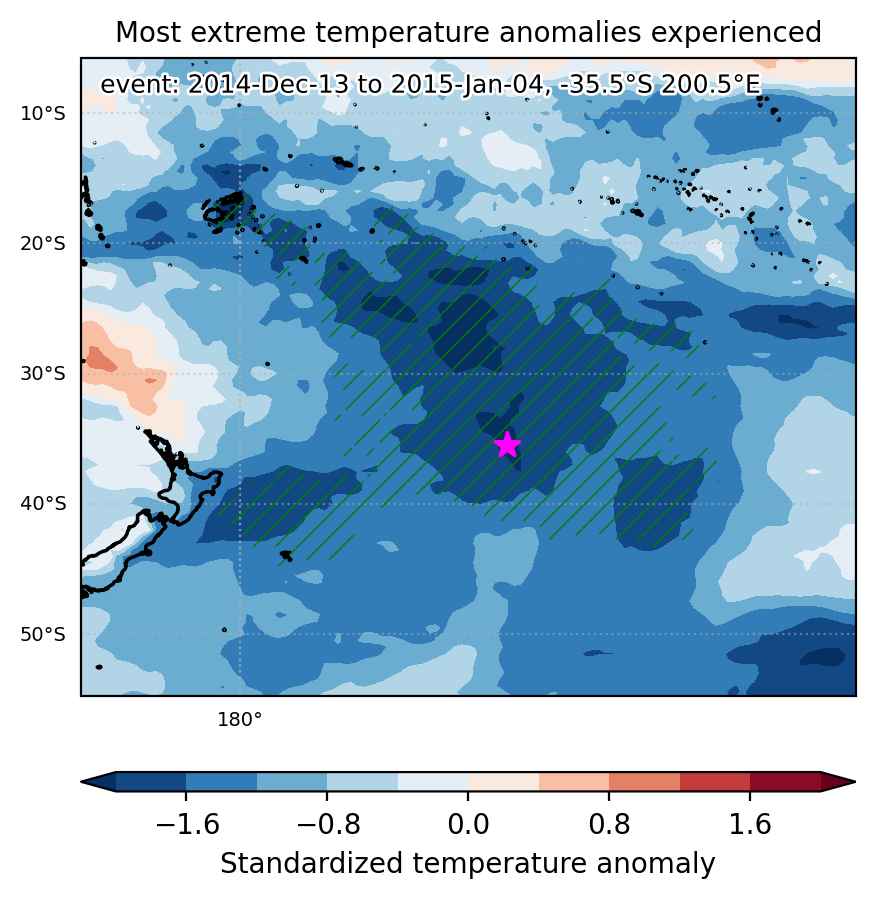
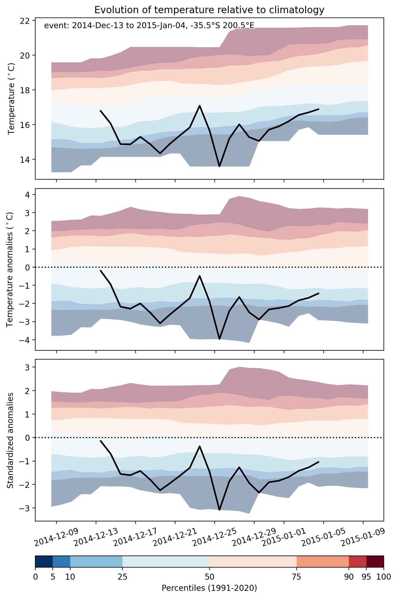
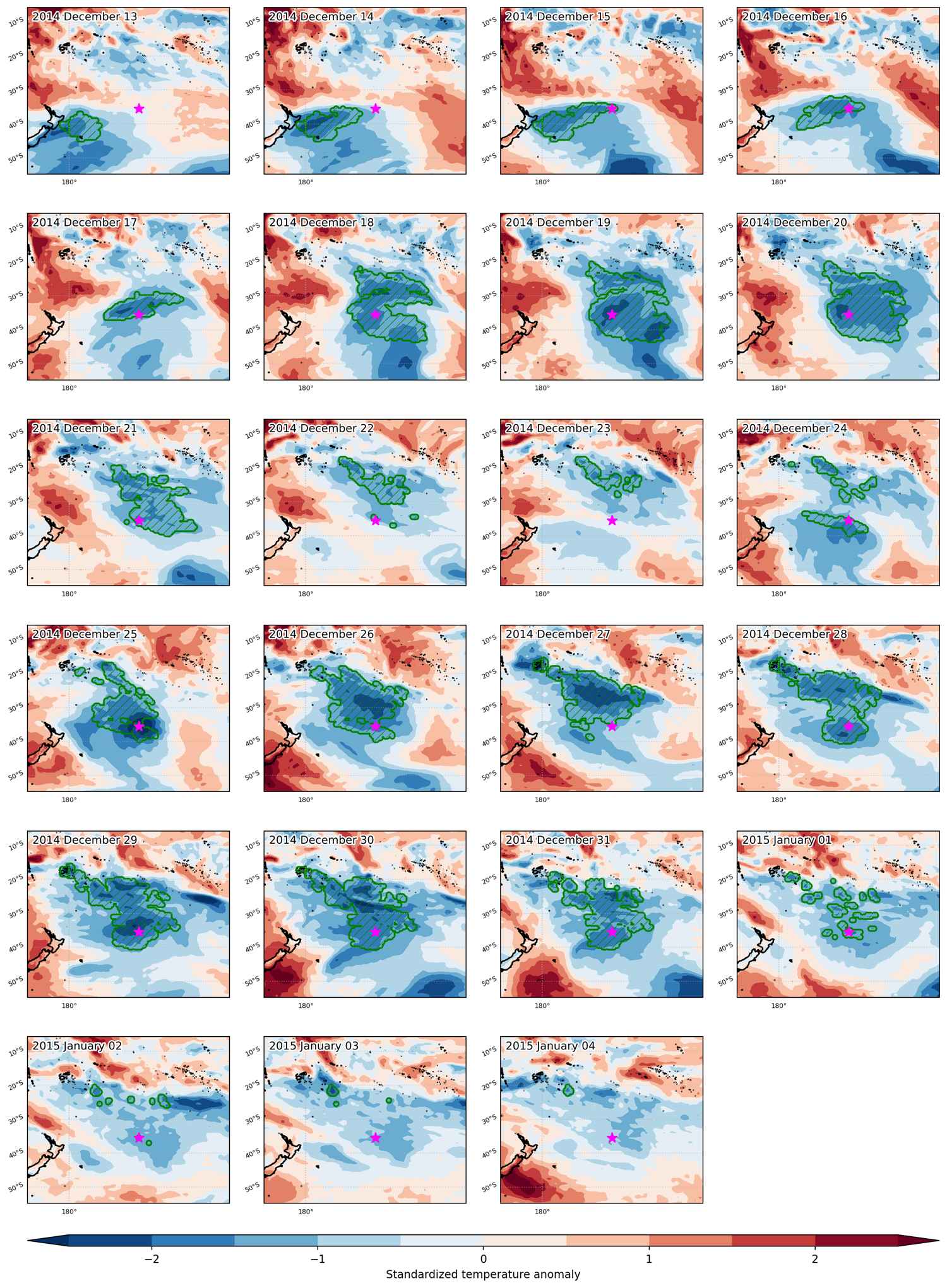
Cold spell occuring from December 13 2014 to January 04 2015 at -35.5°S 200.5°E

Download data: JSON

Event type: Cold spell

Countries affected (identified with ArcGIS Online; provided only for geographical reference):

  • Fiji

Duration: 23 days

Time span: December 13 2014 to January 04 2015

Statistics over entire affected area:

  • Mean temperature anomaly: -2.0 °C
  • Mean temperature: 18.2 °C
  • Minimum temperature anomaly: -4.0 °C
  • Minimum temperature: 9.5 °C

Event center: -35.5°S 200.5°E

Area affected: 5861521 km$^2$


Fig. 1: Map of most extreme temperature anomalies (standardized) experienced during the event. The purple star indicates the center of the extreme event. Green hatching illustrates all areas under the effect of extremes at some time during the event.


Fig. 2: Evolution of temperature at the center of the event. The climatological percentile distribution is illustrated with color shadings.


Fig. 3: Maps illustrating the evolution of standardized temperature anomalies during the event.

Event ID: Cold_spell_2014-Dec-13_to_2015-Jan-04_200.5_-35.5

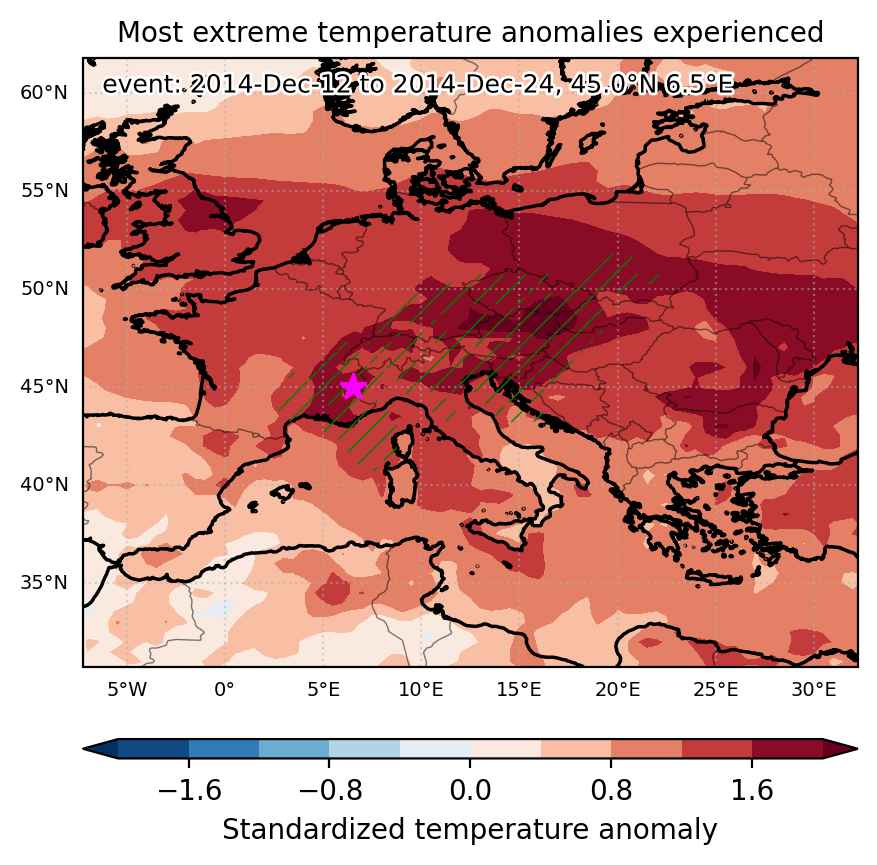
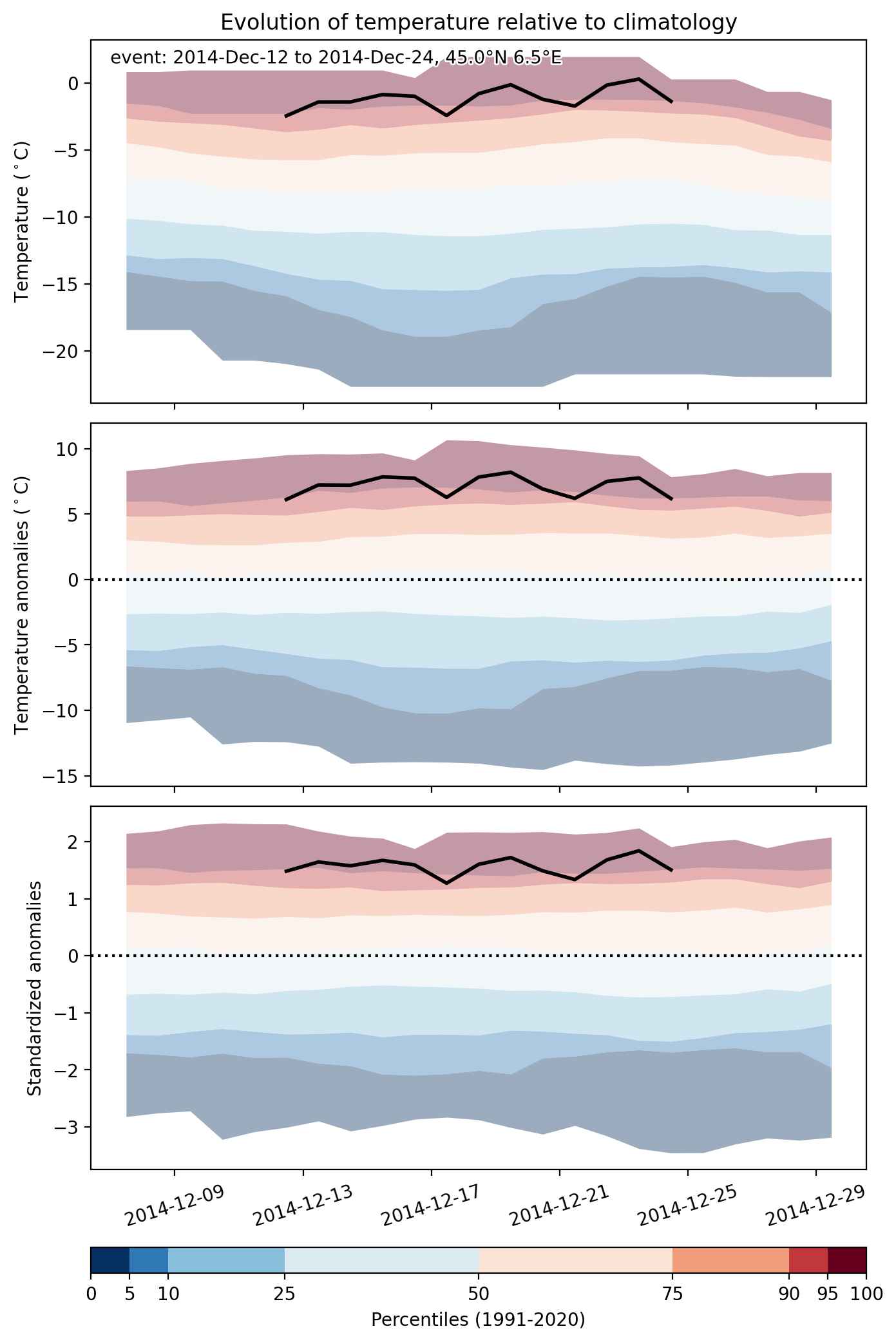
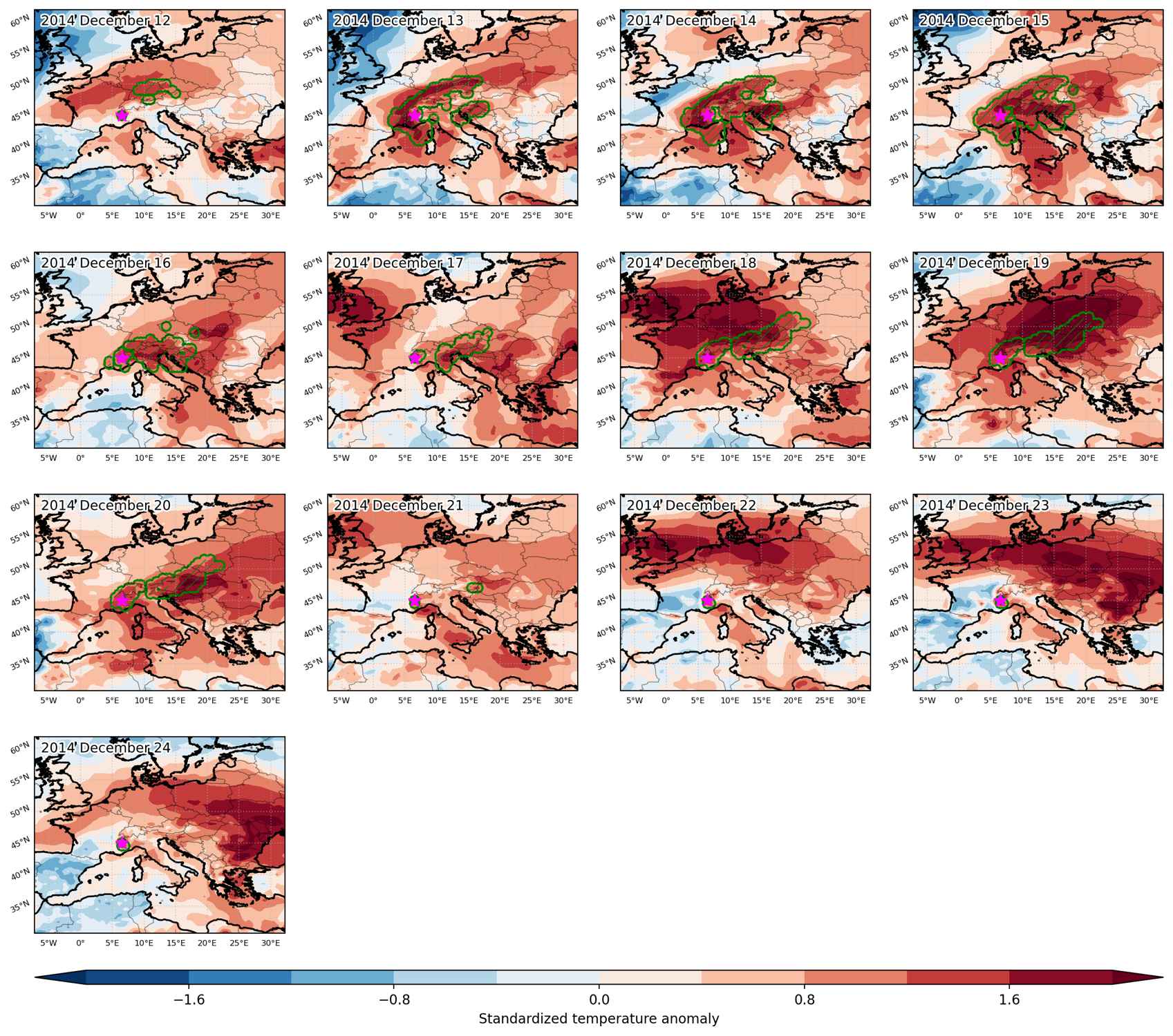
Heat wave occuring from December 12 2014 to December 24 2014 at 45.0°N 6.5°E

Download data: JSON

Event type: Heat wave

Countries affected (identified with ArcGIS Online; provided only for geographical reference):

  • Austria
  • Bosnia and Herzegovina
  • Croatia
  • Czech Republic
  • France
  • Germany
  • Hungary
  • Italy
  • Poland
  • Slovakia
  • Slovenia
  • Switzerland

Duration: 13 days

Time span: December 12 2014 to December 24 2014

Statistics over entire affected area:

  • Mean temperature anomaly: 5.8 °C
  • Mean temperature: 7.0 °C
  • Maximum temperature anomaly: 12.2 °C
  • Maximum temperature: 16.6 °C

Event center: 45.0°N 6.5°E

Area affected: 669734 km$^2$


Fig. 1: Map of most extreme temperature anomalies (standardized) experienced during the event. The purple star indicates the center of the extreme event. Green hatching illustrates all areas under the effect of extremes at some time during the event.


Fig. 2: Evolution of temperature at the center of the event. The climatological percentile distribution is illustrated with color shadings.


Fig. 3: Maps illustrating the evolution of standardized temperature anomalies during the event.

Event ID: Heat_wave_2014-Dec-12_to_2014-Dec-24_6.5_45.0