Heat wave occuring from January 11 2010 to January 18 2010 at 53.5°N 261.5°E

Download data: JSON

Event type: Heat wave

Countries affected (identified with ArcGIS Online; provided only for geographical reference):

  • Canada
  • United States

Duration: 8 days

Time span: January 11 2010 to January 18 2010

Statistics over entire affected area:

  • Mean temperature anomaly: 12.5 °C
  • Mean temperature: -4.8 °C
  • Maximum temperature anomaly: 17.9 °C
  • Maximum temperature: 2.5 °C

Event center: 53.5°N 261.5°E

Area affected: 1003910 km$^2$
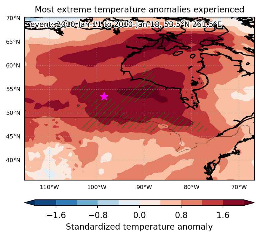

Fig. 1: Map of most extreme temperature anomalies (standardized) experienced during the event. The purple star indicates the center of the extreme event. Green hatching illustrates all areas under the effect of extremes at some time during the event.
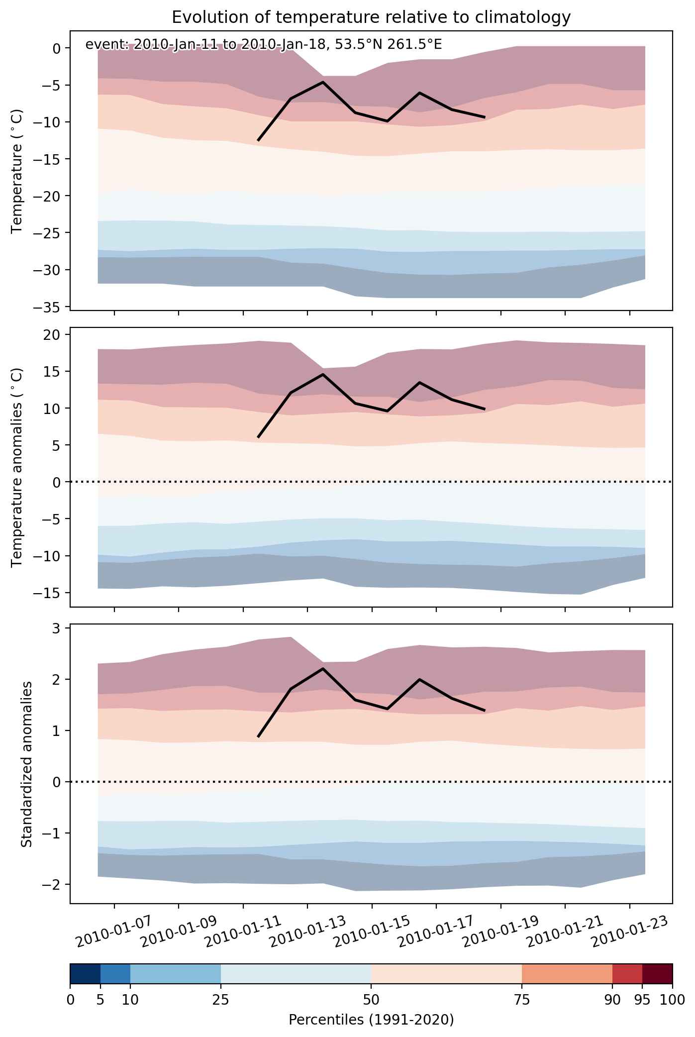


Fig. 2: Evolution of temperature at the center of the event. The climatological percentile distribution is illustrated with color shadings.
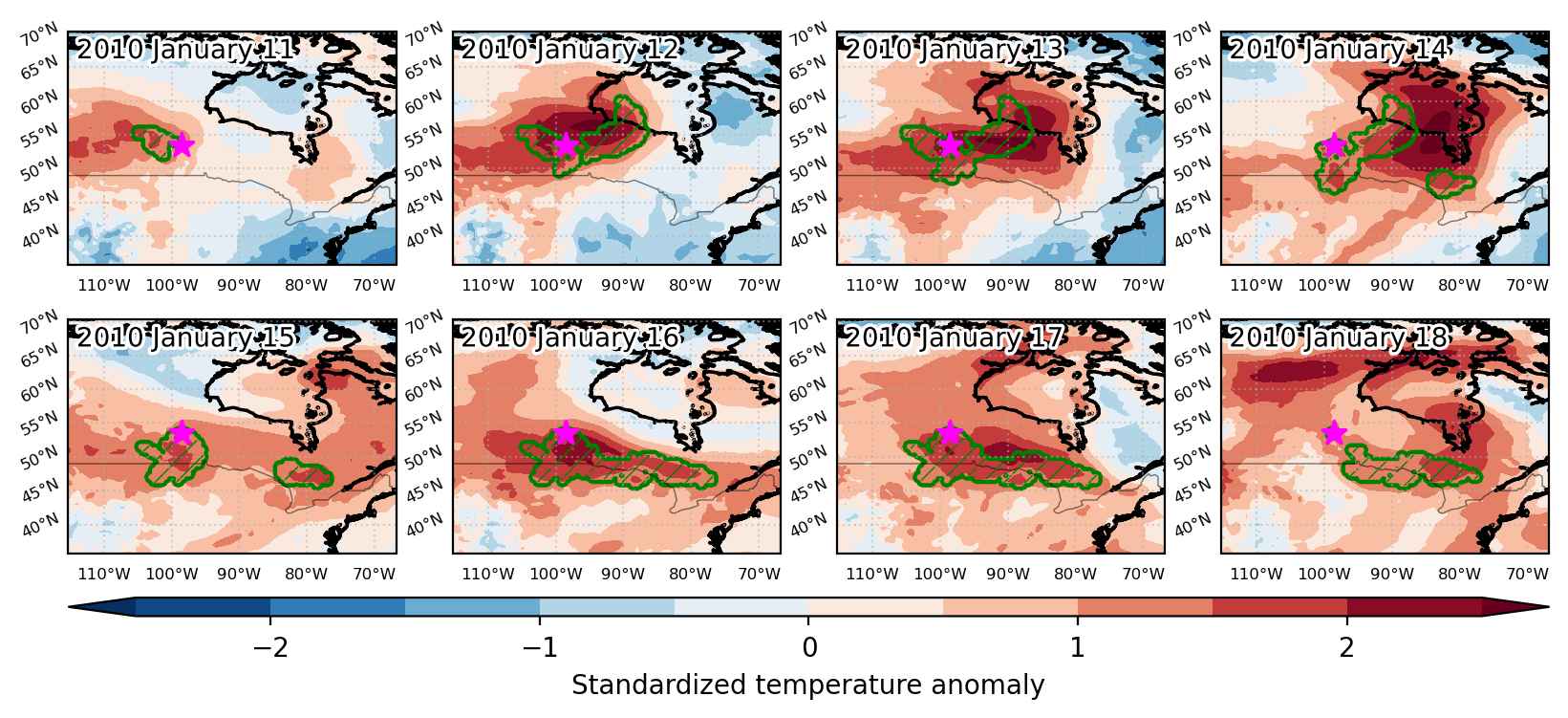


Fig. 3: Maps illustrating the evolution of standardized temperature anomalies during the event.

Event ID: Heat_wave_2010-Jan-11_to_2010-Jan-18_261.5_53.5
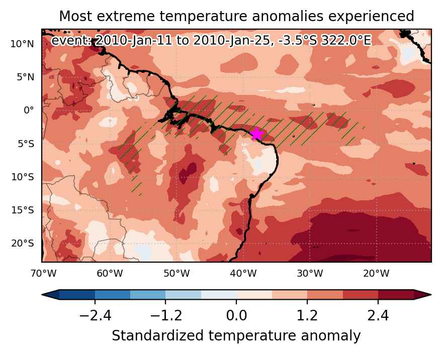
Heat wave occuring from January 11 2010 to January 25 2010 at -3.5°S 322.0°E

Download data: JSON

Event type: Heat wave

Countries affected (identified with ArcGIS Online; provided only for geographical reference):

  • Brazil

Duration: 15 days

Time span: January 11 2010 to January 25 2010

Statistics over entire affected area:

  • Mean temperature anomaly: 1.3 °C
  • Mean temperature: 27.4 °C
  • Maximum temperature anomaly: 3.8 °C
  • Maximum temperature: 32.3 °C

Event center: -3.5°S 322.0°E

Area affected: 1937149 km$^2$


Fig. 1: Map of most extreme temperature anomalies (standardized) experienced during the event. The purple star indicates the center of the extreme event. Green hatching illustrates all areas under the effect of extremes at some time during the event.


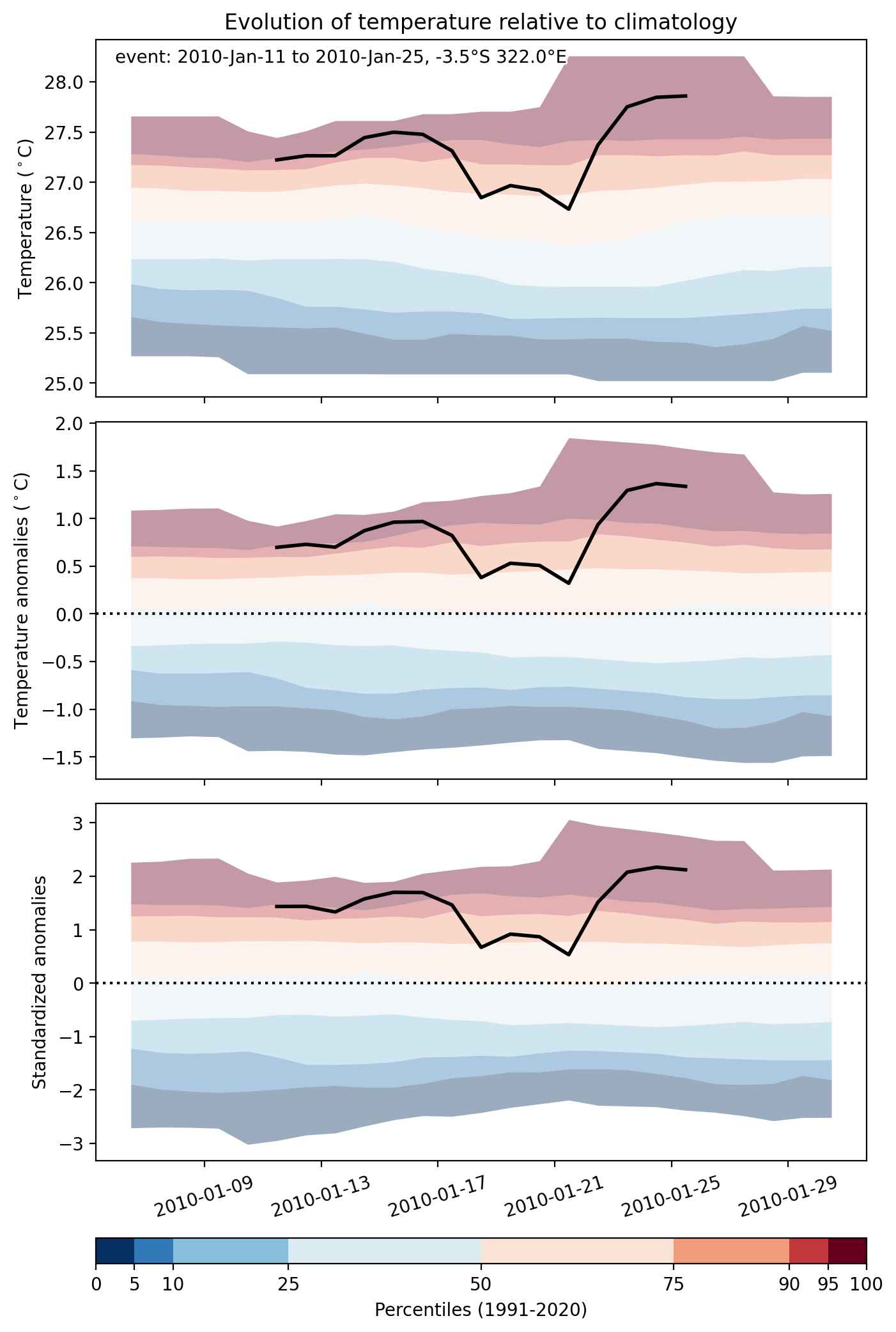
Fig. 2: Evolution of temperature at the center of the event. The climatological percentile distribution is illustrated with color shadings.


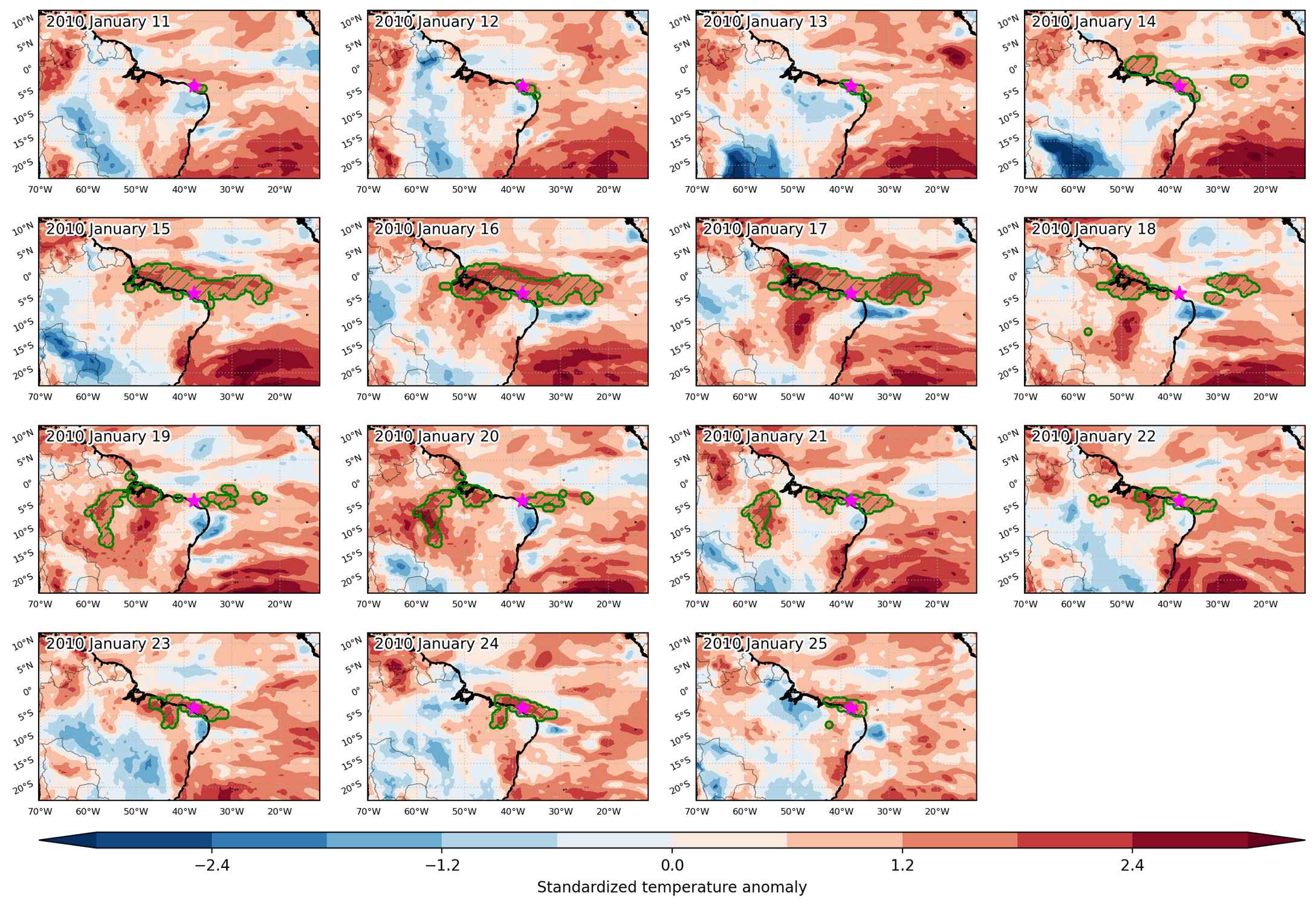
Fig. 3: Maps illustrating the evolution of standardized temperature anomalies during the event.

Event ID: Heat_wave_2010-Jan-11_to_2010-Jan-25_322.0_-3.5

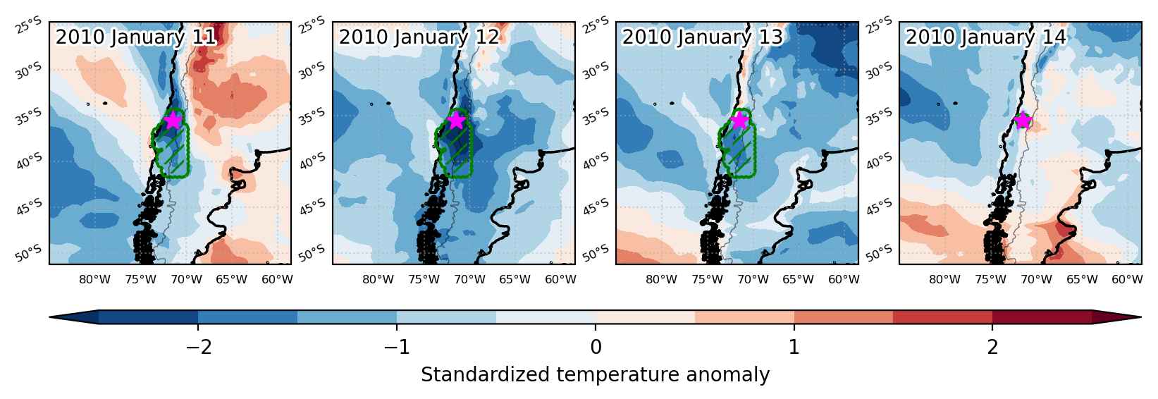
Cold spell occuring from January 11 2010 to January 14 2010 at -35.5°S 288.5°E

Download data: JSON

Event type: Cold spell

Countries affected (identified with ArcGIS Online; provided only for geographical reference):

  • Argentina
  • Chile

Duration: 4 days

Time span: January 11 2010 to January 14 2010

Statistics over entire affected area:

  • Mean temperature anomaly: -5.0 °C
  • Mean temperature: 10.4 °C
  • Minimum temperature anomaly: -9.5 °C
  • Minimum temperature: 1.3 °C

Event center: -35.5°S 288.5°E

Area affected: 133511 km$^2$


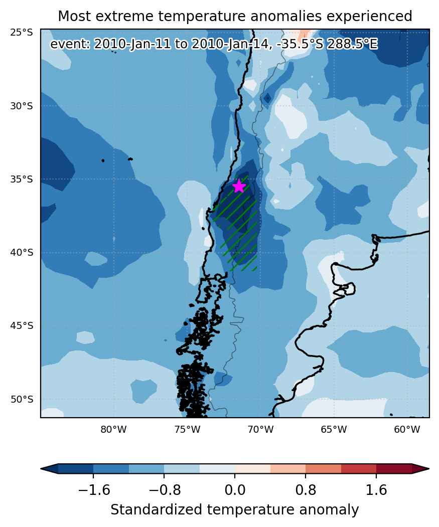
Fig. 1: Map of most extreme temperature anomalies (standardized) experienced during the event. The purple star indicates the center of the extreme event. Green hatching illustrates all areas under the effect of extremes at some time during the event.


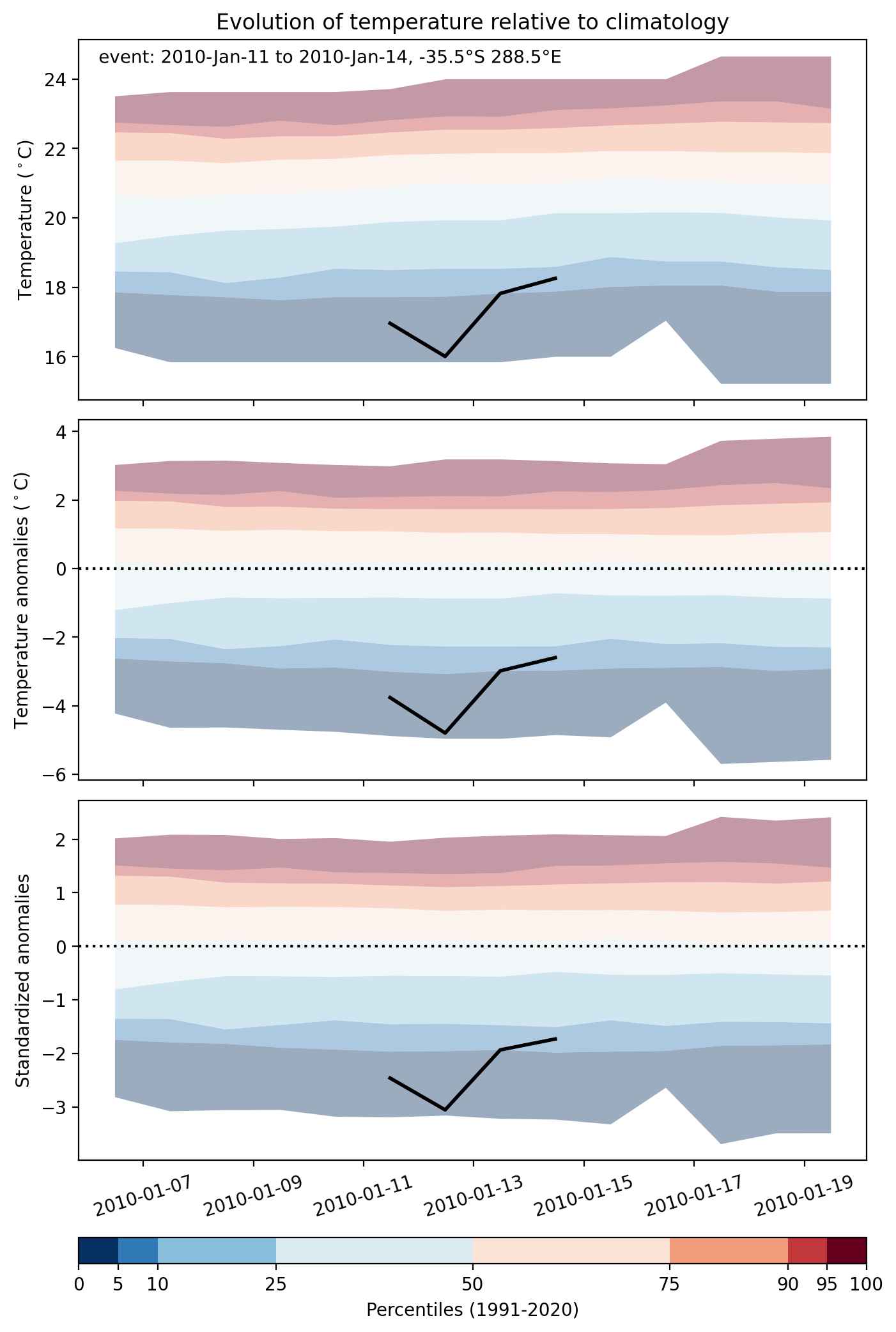
Fig. 2: Evolution of temperature at the center of the event. The climatological percentile distribution is illustrated with color shadings.


Fig. 3: Maps illustrating the evolution of standardized temperature anomalies during the event.

Event ID: Cold_spell_2010-Jan-11_to_2010-Jan-14_288.5_-35.5

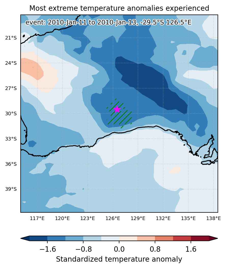
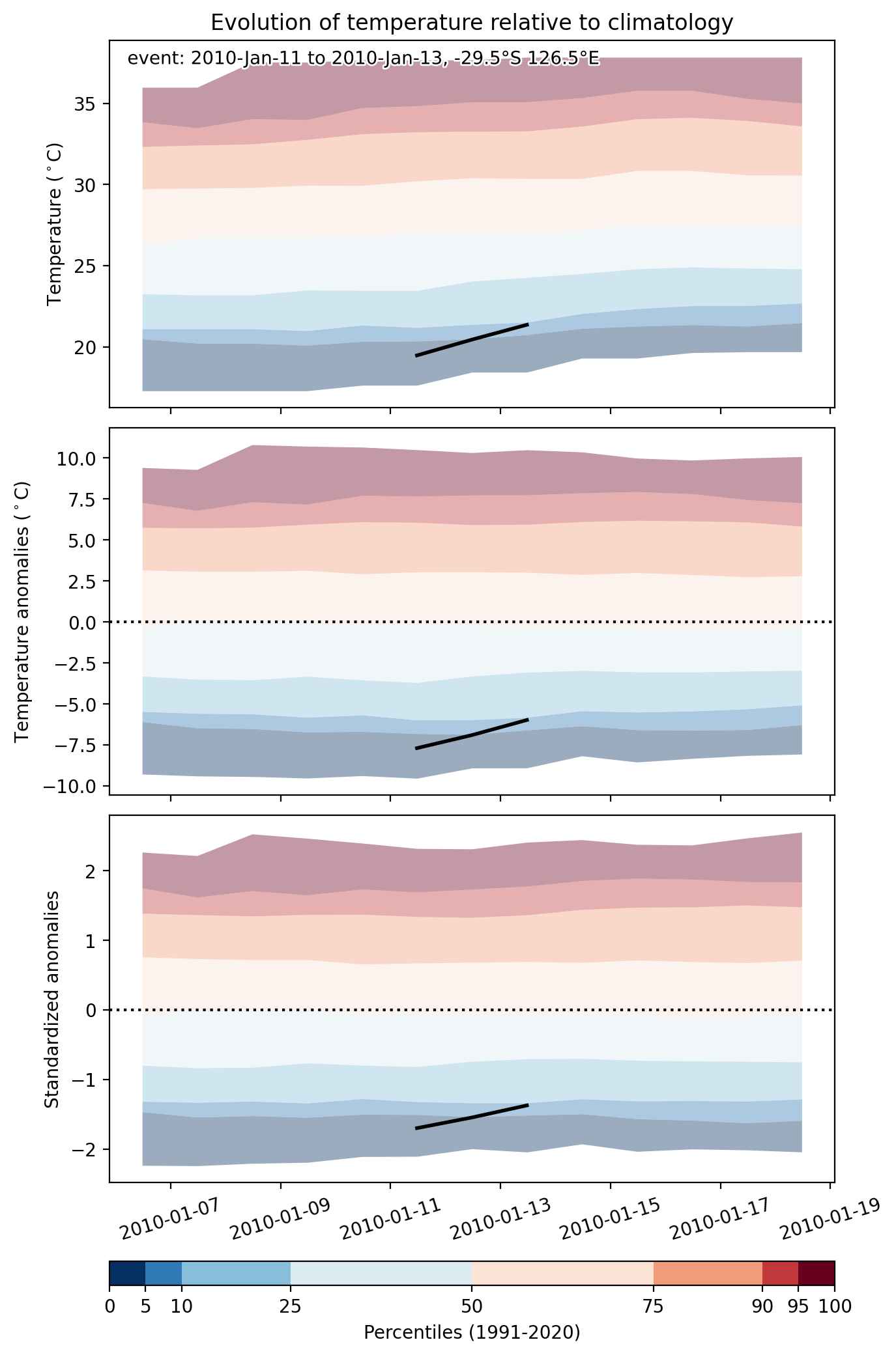
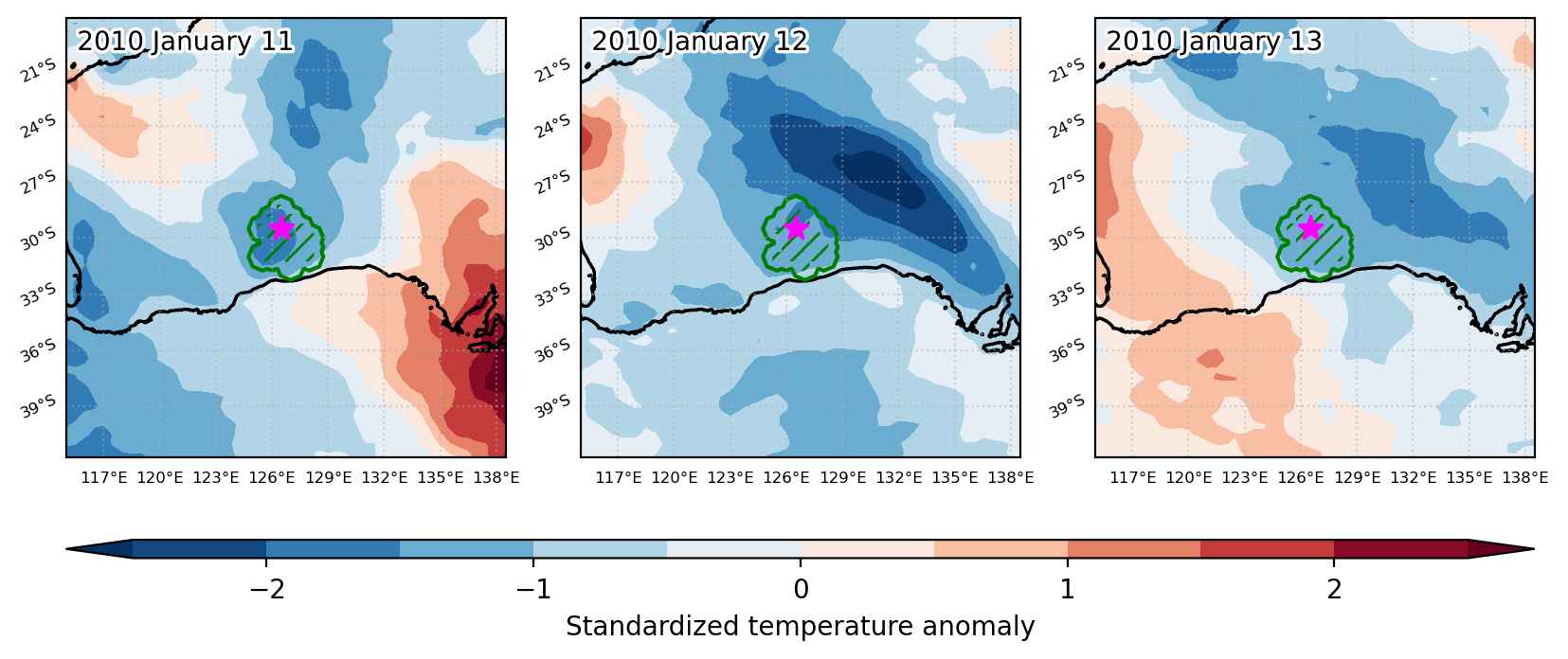
Cold spell occuring from January 11 2010 to January 13 2010 at -29.5°S 126.5°E

Download data: JSON

Event type: Cold spell

Countries affected (identified with ArcGIS Online; provided only for geographical reference):

  • Australia

Duration: 3 days

Time span: January 11 2010 to January 13 2010

Statistics over entire affected area:

  • Mean temperature anomaly: -6.1 °C
  • Mean temperature: 19.6 °C
  • Minimum temperature anomaly: -7.9 °C
  • Minimum temperature: 17.9 °C

Event center: -29.5°S 126.5°E

Area affected: 66822 km$^2$


Fig. 1: Map of most extreme temperature anomalies (standardized) experienced during the event. The purple star indicates the center of the extreme event. Green hatching illustrates all areas under the effect of extremes at some time during the event.


Fig. 2: Evolution of temperature at the center of the event. The climatological percentile distribution is illustrated with color shadings.


Fig. 3: Maps illustrating the evolution of standardized temperature anomalies during the event.

Event ID: Cold_spell_2010-Jan-11_to_2010-Jan-13_126.5_-29.5

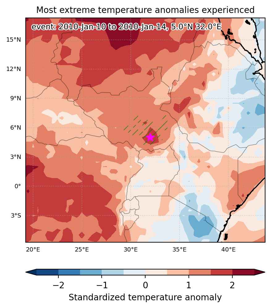
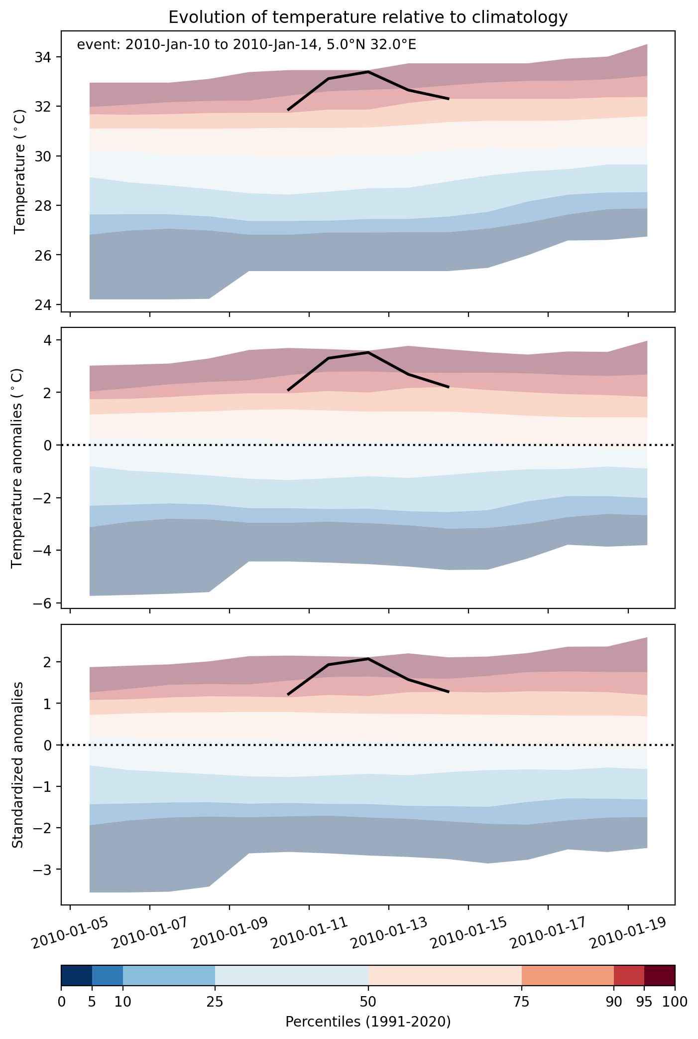
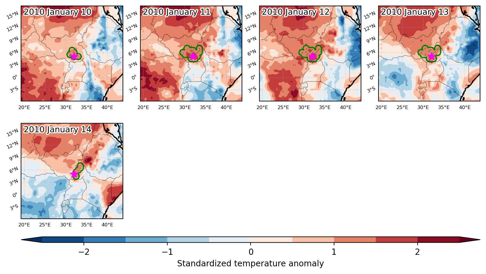
Heat wave occuring from January 10 2010 to January 14 2010 at 5.0°N 32.0°E

Download data: JSON

Event type: Heat wave

Countries affected (identified with ArcGIS Online; provided only for geographical reference):

  • South Sudan

Duration: 5 days

Time span: January 10 2010 to January 14 2010

Statistics over entire affected area:

  • Mean temperature anomaly: 2.5 °C
  • Mean temperature: 31.9 °C
  • Maximum temperature anomaly: 3.5 °C
  • Maximum temperature: 33.4 °C

Event center: 5.0°N 32.0°E

Area affected: 70732 km$^2$


Fig. 1: Map of most extreme temperature anomalies (standardized) experienced during the event. The purple star indicates the center of the extreme event. Green hatching illustrates all areas under the effect of extremes at some time during the event.


Fig. 2: Evolution of temperature at the center of the event. The climatological percentile distribution is illustrated with color shadings.


Fig. 3: Maps illustrating the evolution of standardized temperature anomalies during the event.

Event ID: Heat_wave_2010-Jan-10_to_2010-Jan-14_32.0_5.0

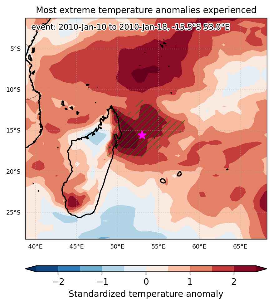
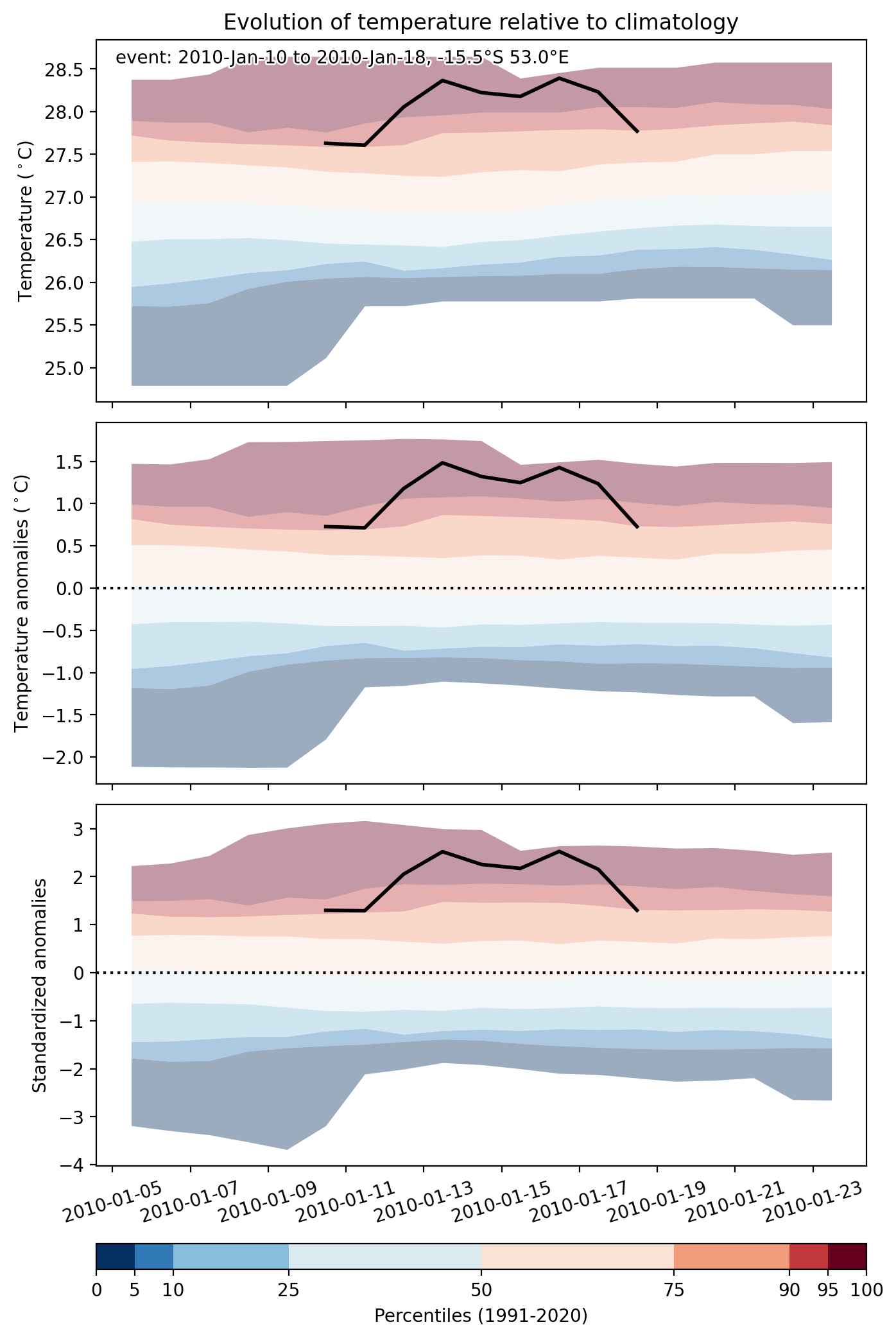
Heat wave occuring from January 10 2010 to January 18 2010 at -15.5°S 53.0°E

Download data: JSON

Event type: Heat wave

Countries affected (identified with ArcGIS Online; provided only for geographical reference):

  • Madagascar

Duration: 9 days

Time span: January 10 2010 to January 18 2010

Statistics over entire affected area:

  • Mean temperature anomaly: 1.3 °C
  • Mean temperature: 28.0 °C
  • Maximum temperature anomaly: 2.9 °C
  • Maximum temperature: 29.1 °C

Event center: -15.5°S 53.0°E

Area affected: 450627 km$^2$


Fig. 1: Map of most extreme temperature anomalies (standardized) experienced during the event. The purple star indicates the center of the extreme event. Green hatching illustrates all areas under the effect of extremes at some time during the event.


Fig. 2: Evolution of temperature at the center of the event. The climatological percentile distribution is illustrated with color shadings.


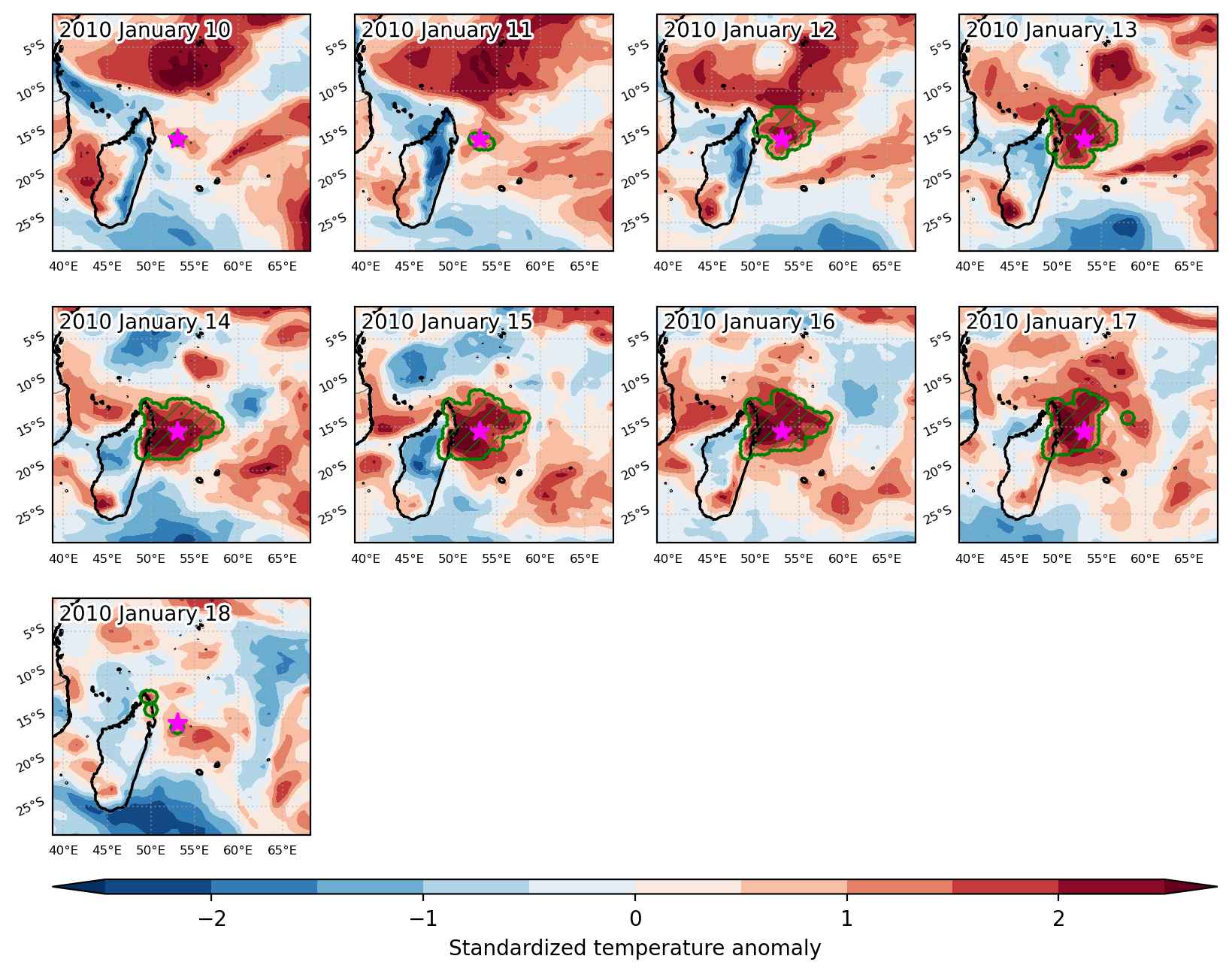
Fig. 3: Maps illustrating the evolution of standardized temperature anomalies during the event.

Event ID: Heat_wave_2010-Jan-10_to_2010-Jan-18_53.0_-15.5

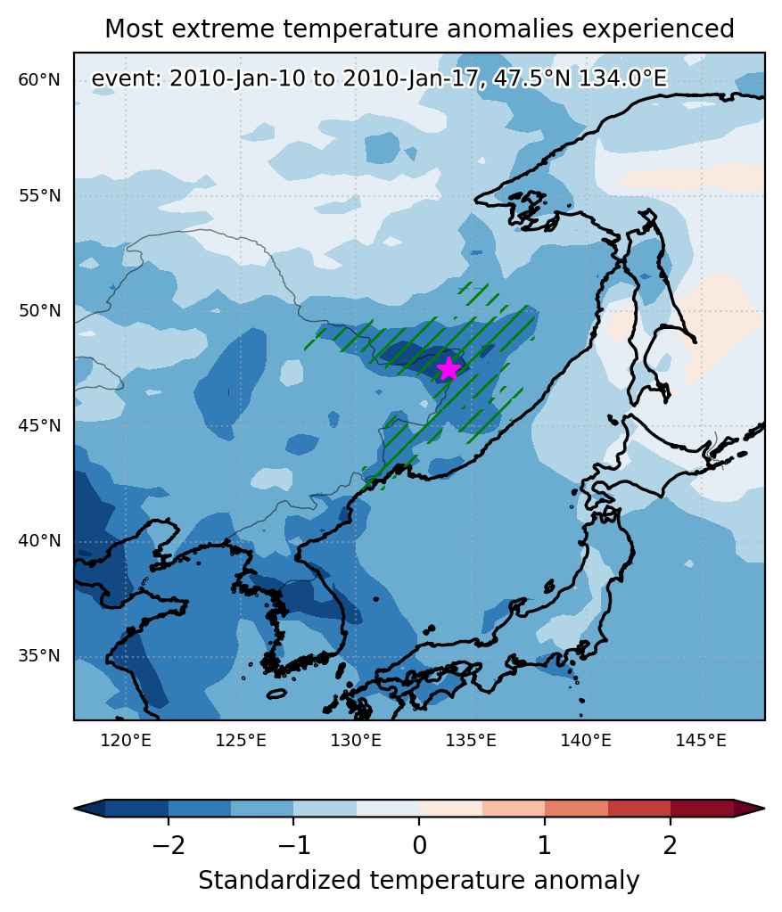
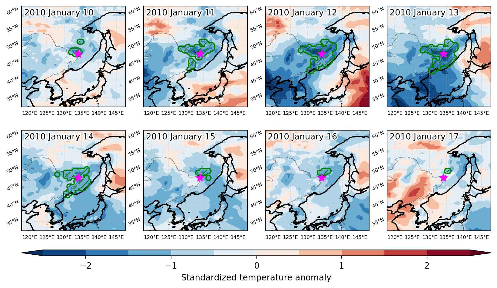
Cold spell occuring from January 10 2010 to January 17 2010 at 47.5°N 134.0°E

Download data: JSON

Event type: Cold spell

Countries affected (identified with ArcGIS Online; provided only for geographical reference):

  • China
  • North Korea
  • Russian Federation

Duration: 8 days

Time span: January 10 2010 to January 17 2010

Statistics over entire affected area:

  • Mean temperature anomaly: -8.6 °C
  • Mean temperature: -30.1 °C
  • Minimum temperature anomaly: -14.1 °C
  • Minimum temperature: -35.3 °C

Event center: 47.5°N 134.0°E

Area affected: 255182 km$^2$


Fig. 1: Map of most extreme temperature anomalies (standardized) experienced during the event. The purple star indicates the center of the extreme event. Green hatching illustrates all areas under the effect of extremes at some time during the event.


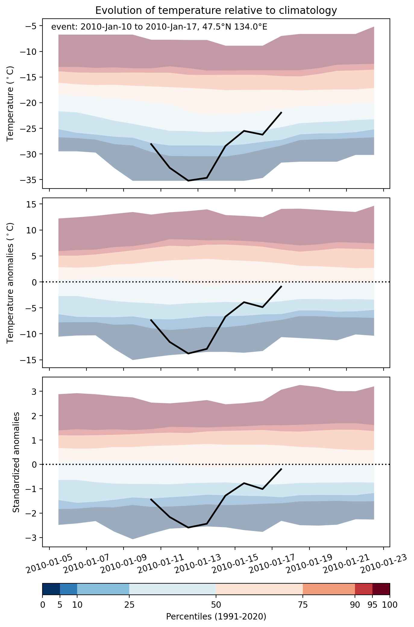
Fig. 2: Evolution of temperature at the center of the event. The climatological percentile distribution is illustrated with color shadings.


Fig. 3: Maps illustrating the evolution of standardized temperature anomalies during the event.

Event ID: Cold_spell_2010-Jan-10_to_2010-Jan-17_134.0_47.5

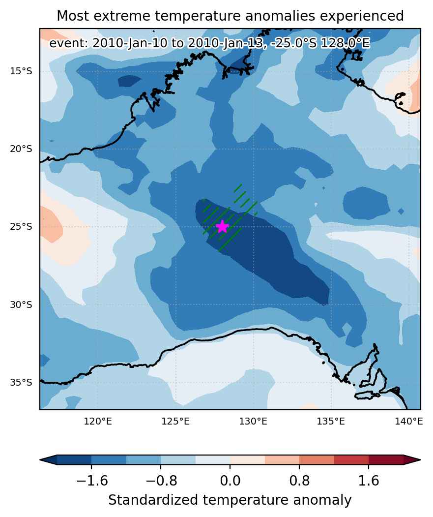
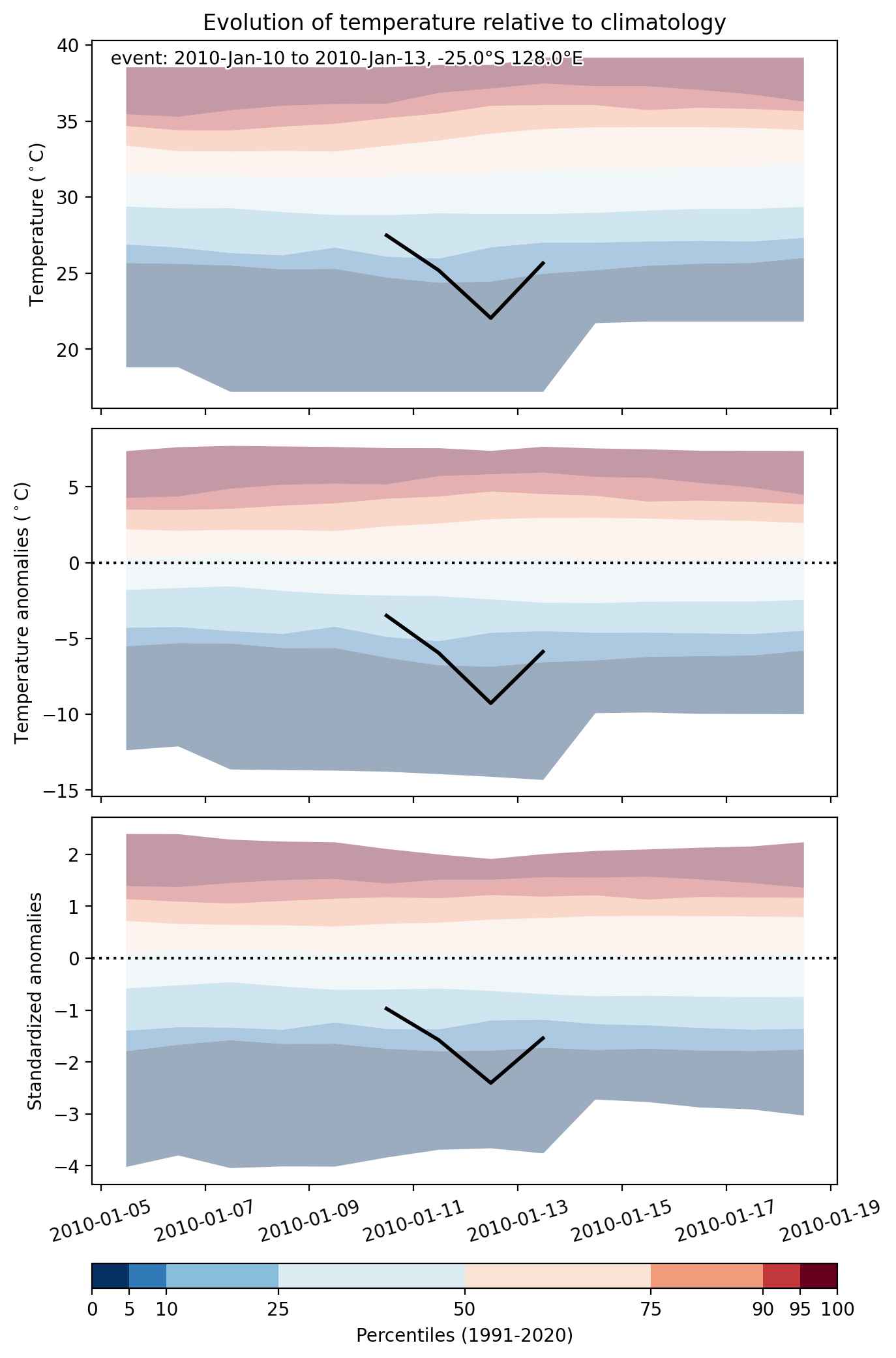
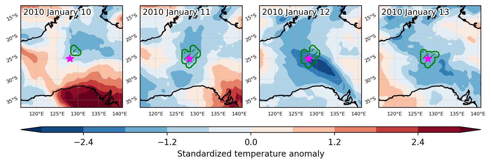
Cold spell occuring from January 10 2010 to January 13 2010 at -25.0°S 128.0°E

Download data: JSON

Event type: Cold spell

Countries affected (identified with ArcGIS Online; provided only for geographical reference):

  • Australia

Duration: 4 days

Time span: January 10 2010 to January 13 2010

Statistics over entire affected area:

  • Mean temperature anomaly: -6.2 °C
  • Mean temperature: 25.2 °C
  • Minimum temperature anomaly: -10.1 °C
  • Minimum temperature: 19.5 °C

Event center: -25.0°S 128.0°E

Area affected: 87172 km$^2$


Fig. 1: Map of most extreme temperature anomalies (standardized) experienced during the event. The purple star indicates the center of the extreme event. Green hatching illustrates all areas under the effect of extremes at some time during the event.


Fig. 2: Evolution of temperature at the center of the event. The climatological percentile distribution is illustrated with color shadings.


Fig. 3: Maps illustrating the evolution of standardized temperature anomalies during the event.

Event ID: Cold_spell_2010-Jan-10_to_2010-Jan-13_128.0_-25.0

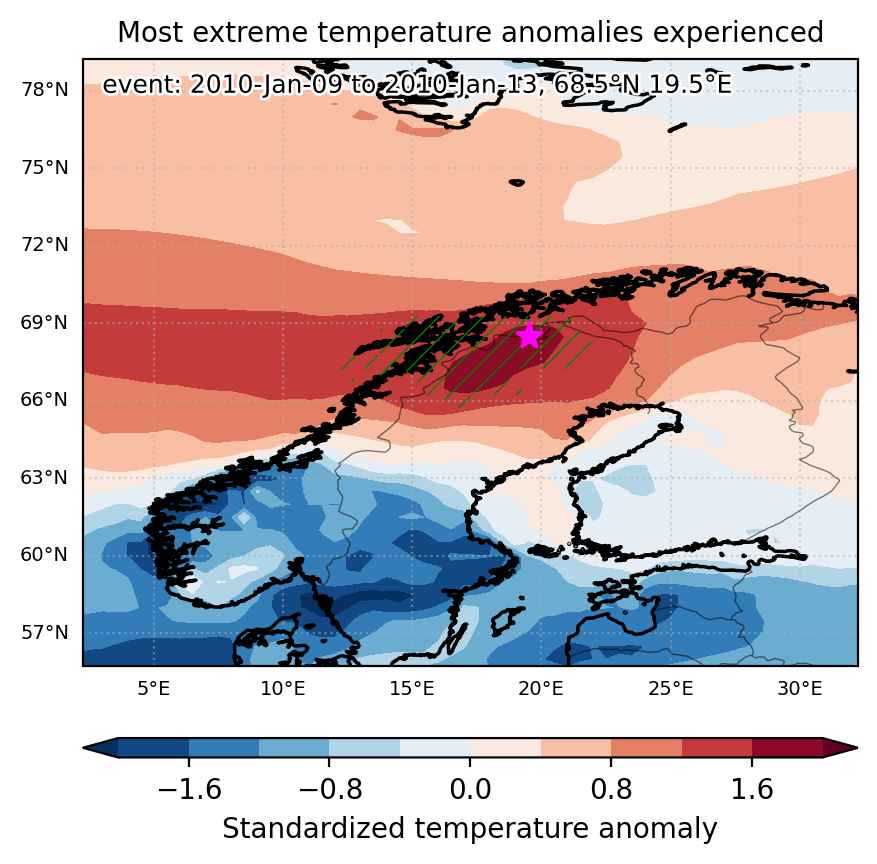
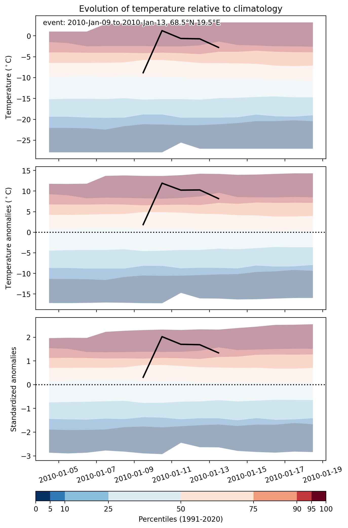
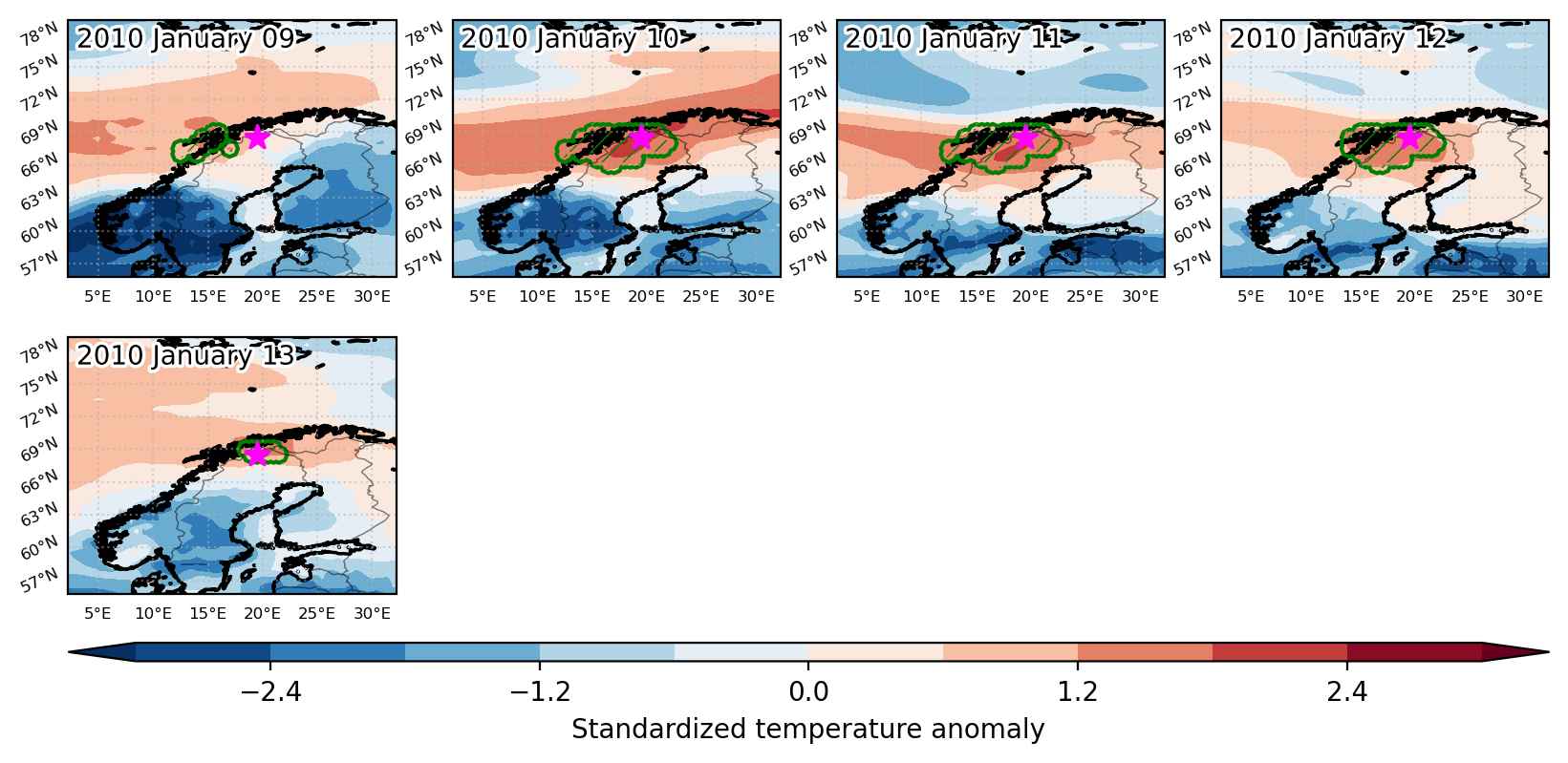
Heat wave occuring from January 09 2010 to January 13 2010 at 68.5°N 19.5°E

Download data: JSON

Event type: Heat wave

Countries affected (identified with ArcGIS Online; provided only for geographical reference):

  • Finland
  • Norway
  • Sweden

Duration: 5 days

Time span: January 09 2010 to January 13 2010

Statistics over entire affected area:

  • Mean temperature anomaly: 8.6 °C
  • Mean temperature: 1.7 °C
  • Maximum temperature anomaly: 12.8 °C
  • Maximum temperature: 6.8 °C

Event center: 68.5°N 19.5°E

Area affected: 98032 km$^2$


Fig. 1: Map of most extreme temperature anomalies (standardized) experienced during the event. The purple star indicates the center of the extreme event. Green hatching illustrates all areas under the effect of extremes at some time during the event.


Fig. 2: Evolution of temperature at the center of the event. The climatological percentile distribution is illustrated with color shadings.


Fig. 3: Maps illustrating the evolution of standardized temperature anomalies during the event.

Event ID: Heat_wave_2010-Jan-09_to_2010-Jan-13_19.5_68.5

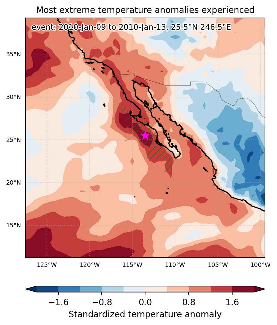
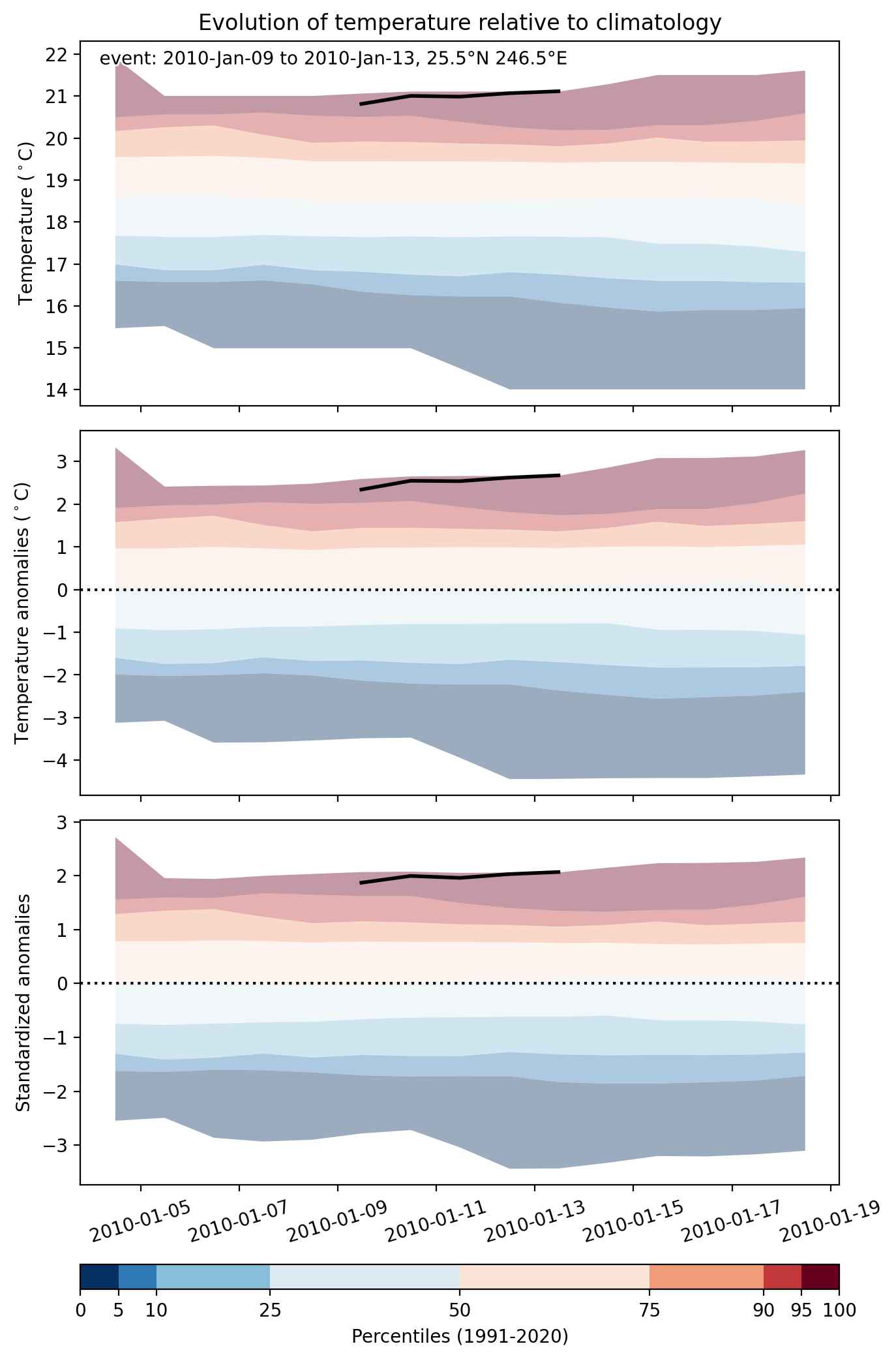
Heat wave occuring from January 09 2010 to January 13 2010 at 25.5°N 246.5°E

Download data: JSON

Event type: Heat wave

Countries affected (identified with ArcGIS Online; provided only for geographical reference):

  • Mexico

Duration: 5 days

Time span: January 09 2010 to January 13 2010

Statistics over entire affected area:

  • Mean temperature anomaly: 2.0 °C
  • Mean temperature: 20.7 °C
  • Maximum temperature anomaly: 3.8 °C
  • Maximum temperature: 23.1 °C

Event center: 25.5°N 246.5°E

Area affected: 139917 km$^2$


Fig. 1: Map of most extreme temperature anomalies (standardized) experienced during the event. The purple star indicates the center of the extreme event. Green hatching illustrates all areas under the effect of extremes at some time during the event.


Fig. 2: Evolution of temperature at the center of the event. The climatological percentile distribution is illustrated with color shadings.


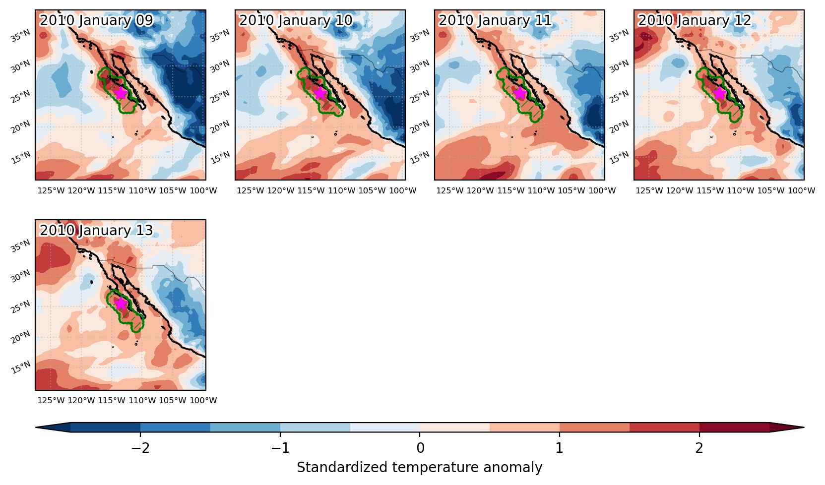
Fig. 3: Maps illustrating the evolution of standardized temperature anomalies during the event.

Event ID: Heat_wave_2010-Jan-09_to_2010-Jan-13_246.5_25.5