Cold spell occuring from February 05 2023 to February 18 2023 at 38.5°N 32.5°E

Download data: JSON

Event type: Cold spell

Countries affected (identified with ArcGIS Online; provided only for geographical reference):

  • Albania
  • Armenia
  • Azerbaijan
  • Bosnia and Herzegovina
  • Bulgaria
  • Croatia
  • Cyprus
  • Egypt
  • France
  • Georgia
  • Greece
  • Iran, Islamic Republic of
  • Iraq
  • Italy
  • Libya
  • Montenegro
  • North Macedonia
  • Serbia
  • Türkiye

Duration: 14 days

Time span: February 05 2023 to February 18 2023

Statistics over entire affected area:

  • Mean temperature anomaly: -5.4 °C
  • Mean temperature: 1.9 °C
  • Minimum temperature anomaly: -15.0 °C
  • Minimum temperature: -18.4 °C

Event center: 38.5°N 32.5°E

Area affected: 2013791 km$^2$
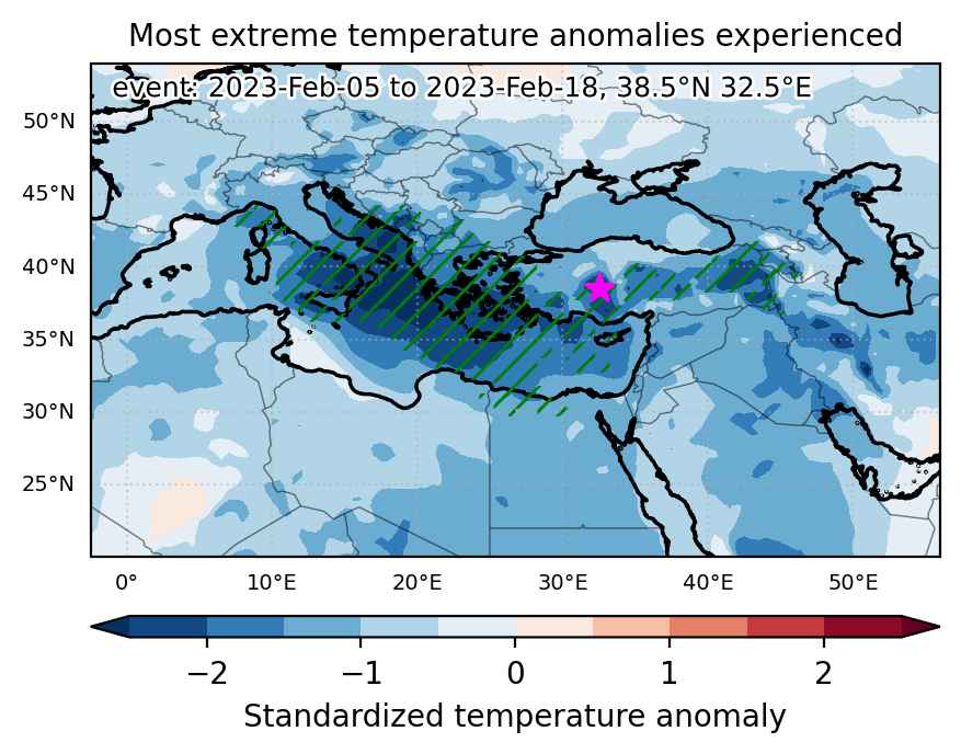

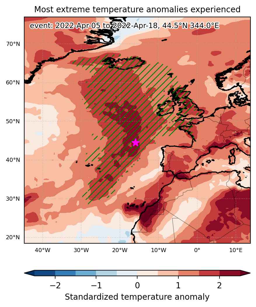
Fig. 1: Map of most extreme temperature anomalies (standardized) experienced during the event. The purple star indicates the center of the extreme event. Green hatching illustrates all areas under the effect of extremes at some time during the event.
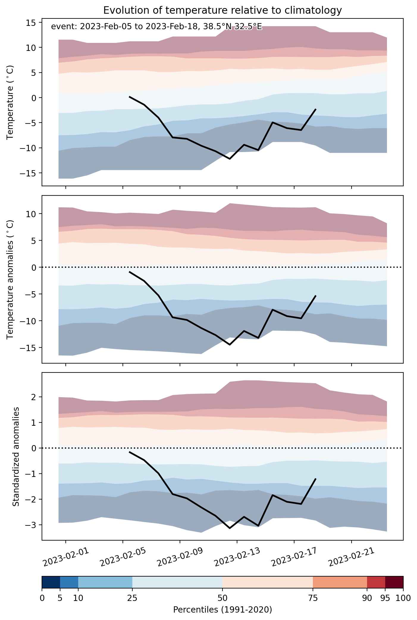


Fig. 2: Evolution of temperature at the center of the event. The climatological percentile distribution is illustrated with color shadings.
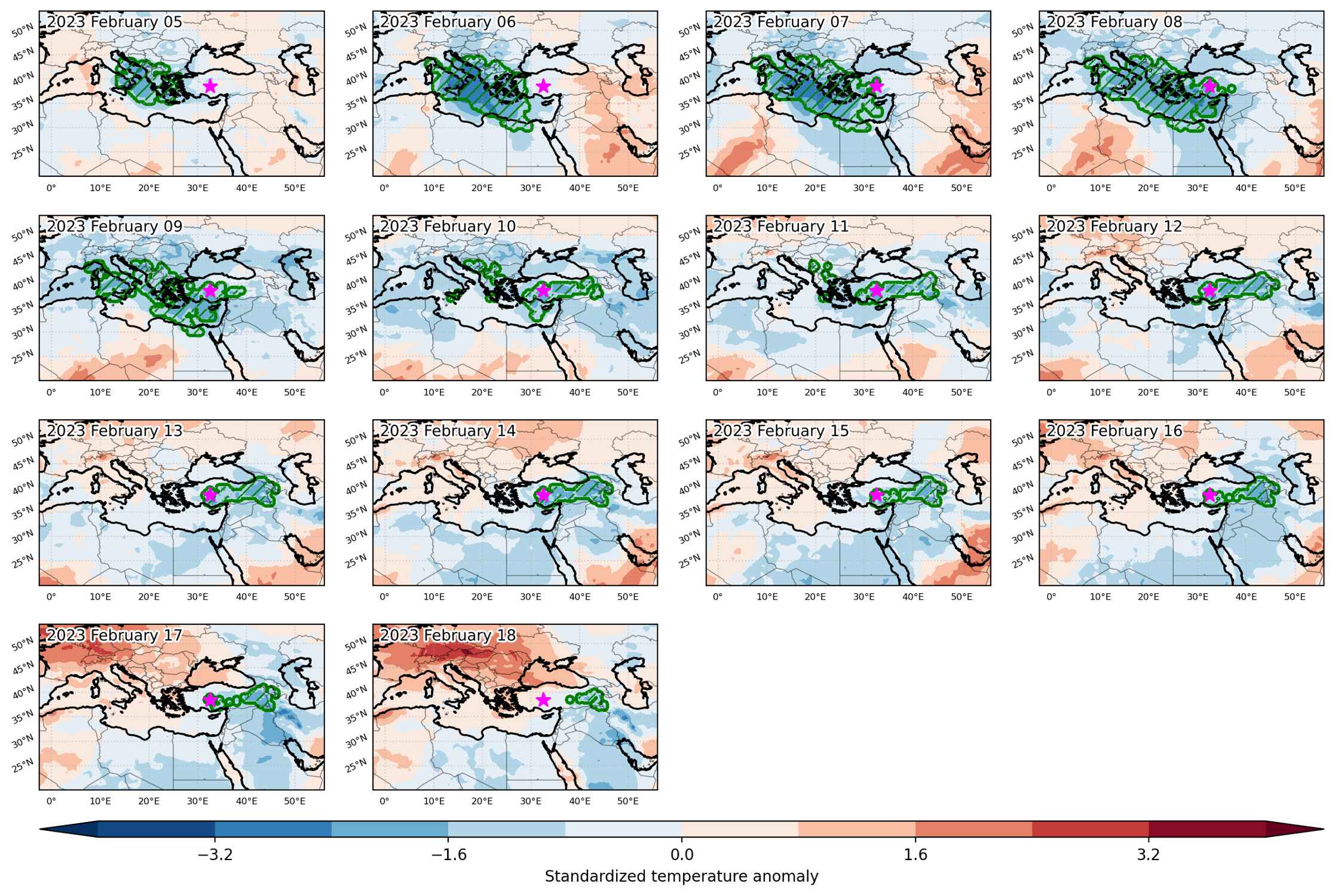


Fig. 3: Maps illustrating the evolution of standardized temperature anomalies during the event.

Event ID: Cold_spell_2023-Feb-05_to_2023-Feb-18_32.5_38.5
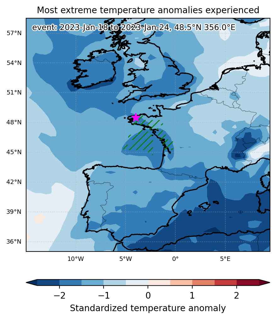
Cold spell occuring from January 18 2023 to January 24 2023 at 48.5°N 356.0°E

Download data: JSON

Event type: Cold spell

Countries affected (identified with ArcGIS Online; provided only for geographical reference):

  • France

Duration: 7 days

Time span: January 18 2023 to January 24 2023

Statistics over entire affected area:

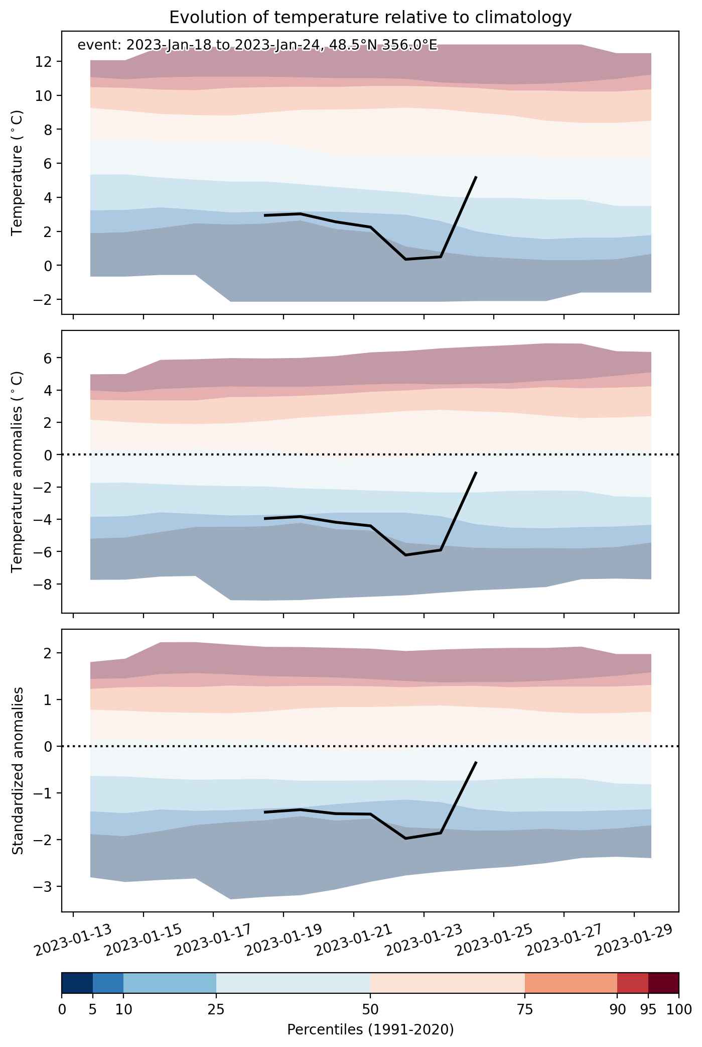
  • Mean temperature anomaly: -4.4 °C
  • Mean temperature: 3.7 °C
  • Minimum temperature anomaly: -7.5 °C
  • Minimum temperature: -1.3 °C

Event center: 48.5°N 356.0°E

Area affected: 74303 km$^2$


Fig. 1: Map of most extreme temperature anomalies (standardized) experienced during the event. The purple star indicates the center of the extreme event. Green hatching illustrates all areas under the effect of extremes at some time during the event.


Fig. 2: Evolution of temperature at the center of the event. The climatological percentile distribution is illustrated with color shadings.


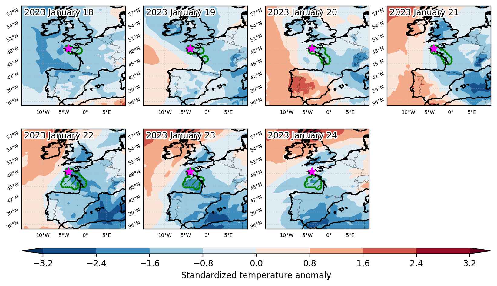
Fig. 3: Maps illustrating the evolution of standardized temperature anomalies during the event.

Event ID: Cold_spell_2023-Jan-18_to_2023-Jan-24_356.0_48.5

Cold spell occuring from January 18 2023 to February 03 2023 at 31.5°N 2.5°E

Download data: JSON

Event type: Cold spell

Countries affected (identified with ArcGIS Online; provided only for geographical reference):

  • Algeria
  • Andorra
  • France
  • Germany
  • Italy
  • Libya
  • Mali
  • Mauritania
  • Morocco
  • Portugal
  • Spain
  • Switzerland
  • Tunisia

Duration: 17 days

Time span: January 18 2023 to February 03 2023

Statistics over entire affected area:

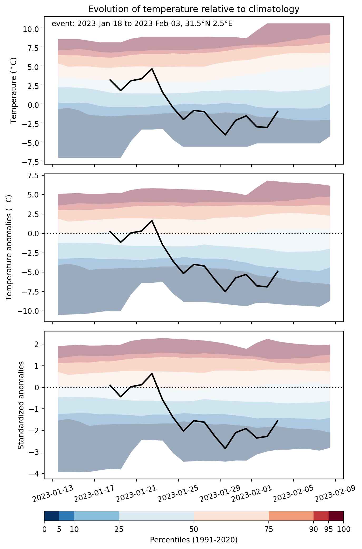
  • Mean temperature anomaly: -4.1 °C
  • Mean temperature: 9.0 °C
  • Minimum temperature anomaly: -8.3 °C
  • Minimum temperature: -5.0 °C

Event center: 33.0°N 355.0°E

Area affected: 4478155 km$^2$


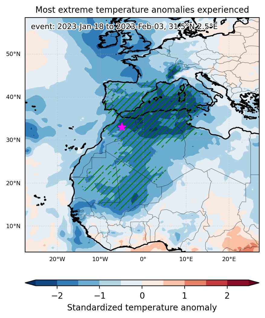
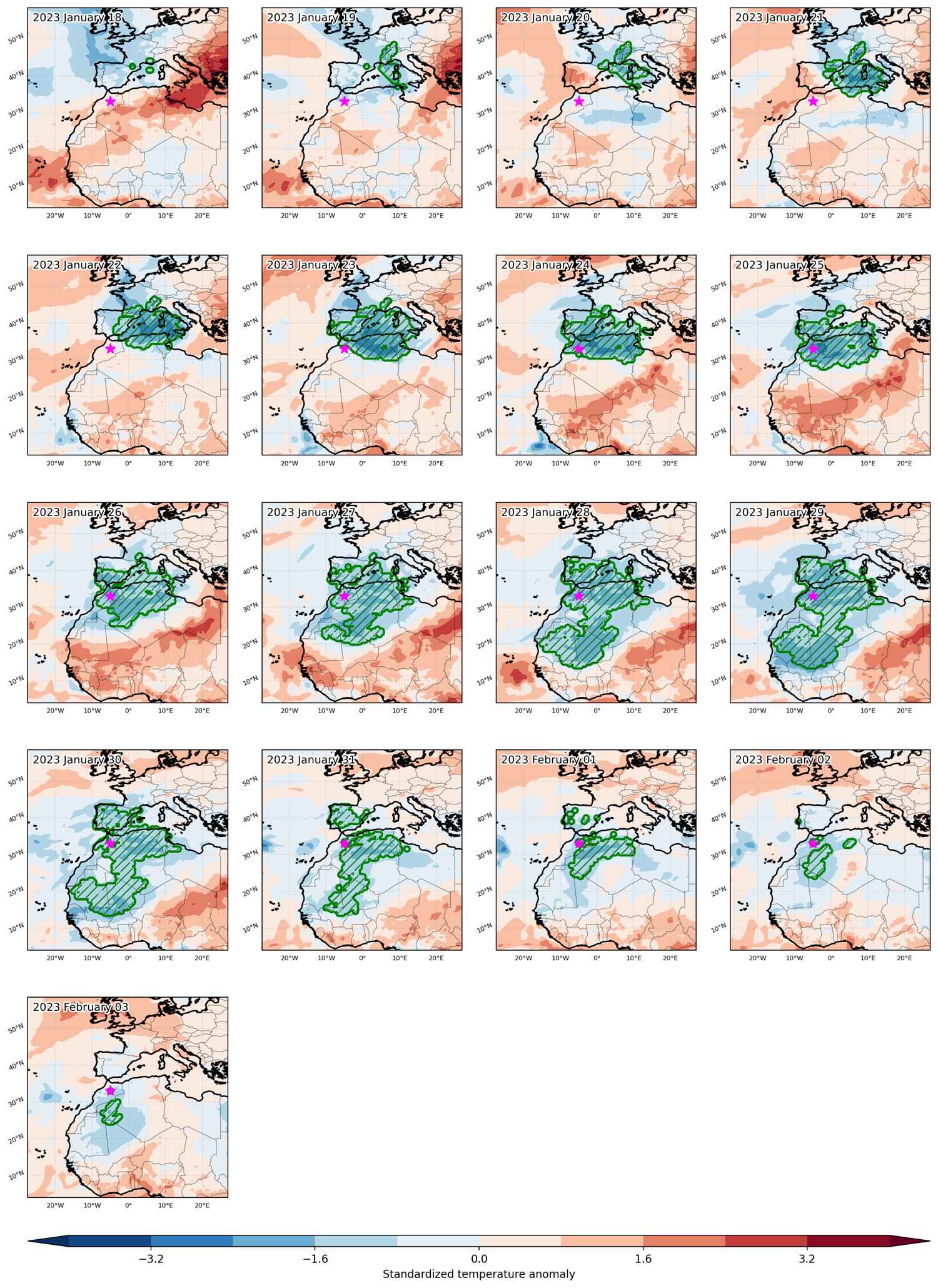
Fig. 1: Map of most extreme temperature anomalies (standardized) experienced during the event. The purple star indicates the center of the extreme event. Green hatching illustrates all areas under the effect of extremes at some time during the event.


Fig. 2: Evolution of temperature at the center of the event. The climatological percentile distribution is illustrated with color shadings.


Fig. 3: Maps illustrating the evolution of standardized temperature anomalies during the event.

Event ID: Cold_spell_2023-Jan-18_to_2023-Feb-03_2.5_31.5

Heat wave occuring from January 10 2023 to January 14 2023 at 45.5°N 358.5°E

Download data: JSON

Event type: Heat wave

Countries affected (identified with ArcGIS Online; provided only for geographical reference):

  • France

Duration: 5 days

Time span: January 10 2023 to January 14 2023

Statistics over entire affected area:

  • Mean temperature anomaly: 3.7 °C
  • Mean temperature: 12.7 °C
  • Maximum temperature anomaly: 5.2 °C
  • Maximum temperature: 14.3 °C

Event center: 45.5°N 358.5°E

Area affected: 98448 km$^2$


Fig. 1: Map of most extreme temperature anomalies (standardized) experienced during the event. The purple star indicates the center of the extreme event. Green hatching illustrates all areas under the effect of extremes at some time during the event.


Fig. 2: Evolution of temperature at the center of the event. The climatological percentile distribution is illustrated with color shadings.


Fig. 3: Maps illustrating the evolution of standardized temperature anomalies during the event.

Event ID: Heat_wave_2023-Jan-10_to_2023-Jan-14_358.5_45.5

Cold spell occuring from December 04 2022 to December 19 2022 at 60.0°N 6.5°E

Download data: JSON

Event type: Cold spell

Countries affected (identified with ArcGIS Online; provided only for geographical reference):

  • Belgium
  • Czechia
  • Denmark
  • Estonia
  • Finland
  • France
  • Germany
  • Iceland
  • Ireland
  • Latvia
  • Lithuania
  • Luxembourg
  • Netherlands
  • Norway
  • Poland
  • Russian Federation
  • Sweden
  • Switzerland
  • United Kingdom

Duration: 16 days

Time span: December 04 2022 to December 19 2022

Statistics over entire affected area:

  • Mean temperature anomaly: -7.6 °C
  • Mean temperature: -6.8 °C
  • Minimum temperature anomaly: -20.2 °C
  • Minimum temperature: -26.2 °C

Event center: 60.0°N 6.5°E

Area affected: 5139665 km$^2$


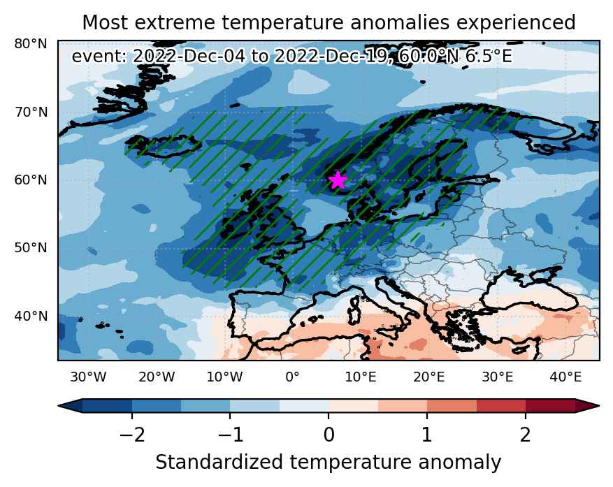
Fig. 1: Map of most extreme temperature anomalies (standardized) experienced during the event. The purple star indicates the center of the extreme event. Green hatching illustrates all areas under the effect of extremes at some time during the event.


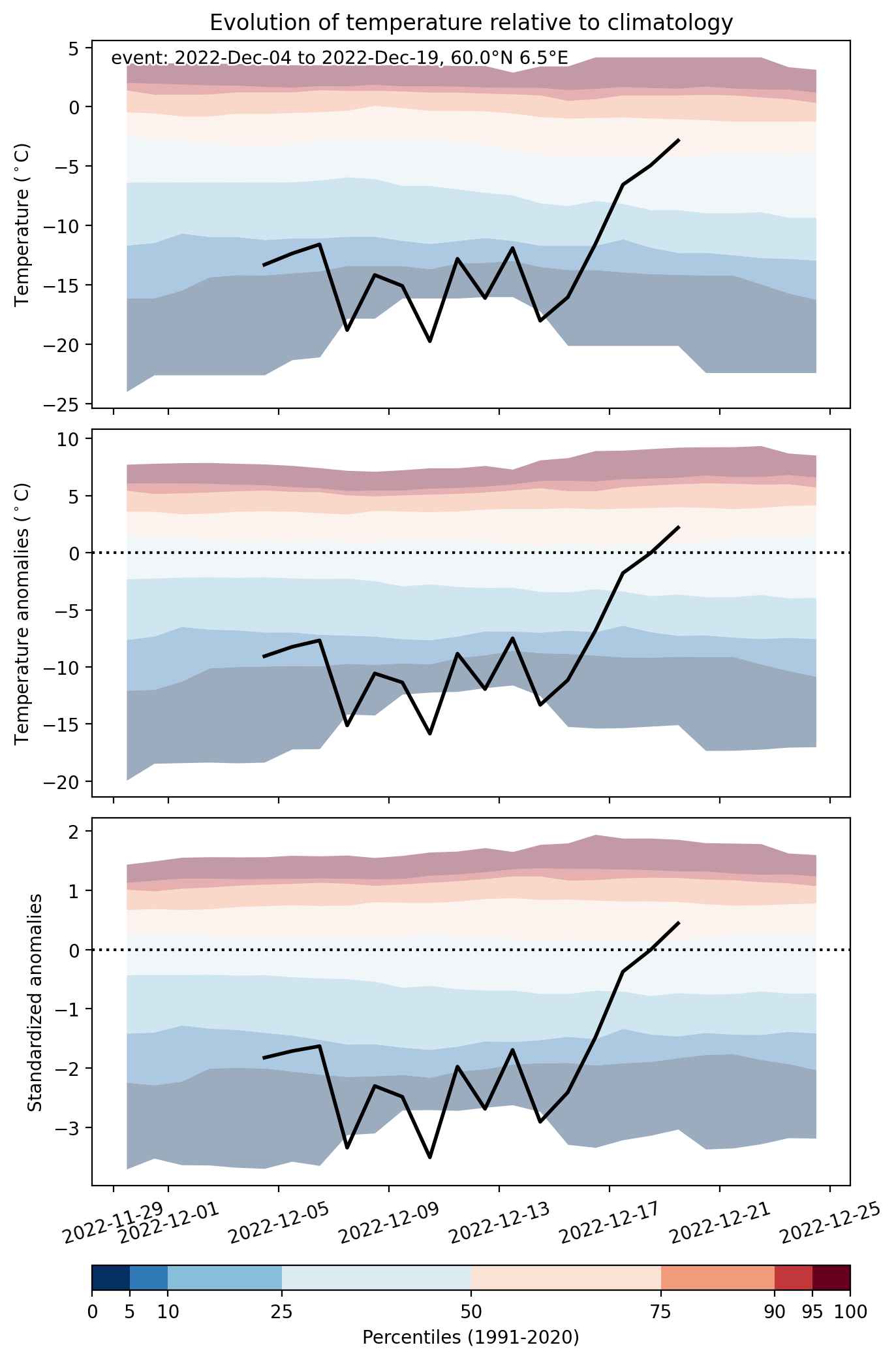
Fig. 2: Evolution of temperature at the center of the event. The climatological percentile distribution is illustrated with color shadings.


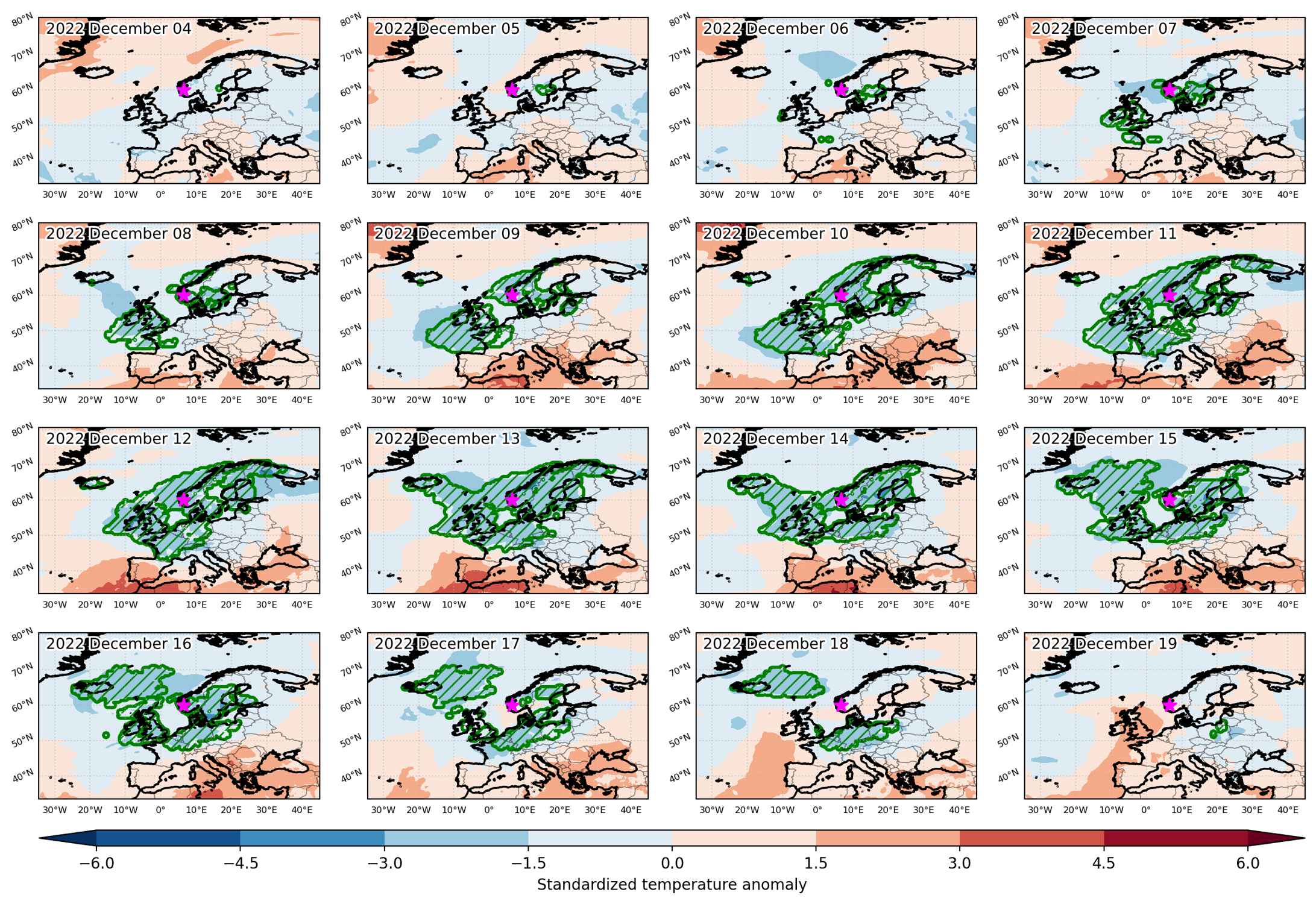
Fig. 3: Maps illustrating the evolution of standardized temperature anomalies during the event.

Event ID: Cold_spell_2022-Dec-04_to_2022-Dec-19_6.5_60.0

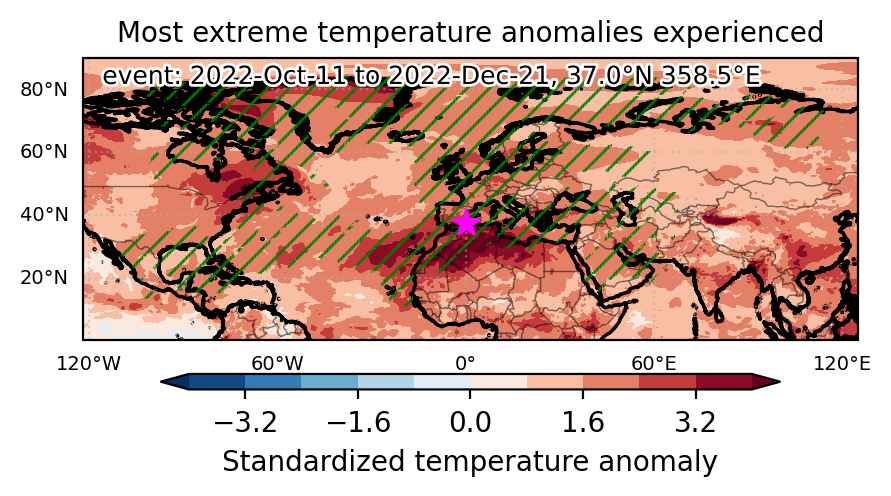
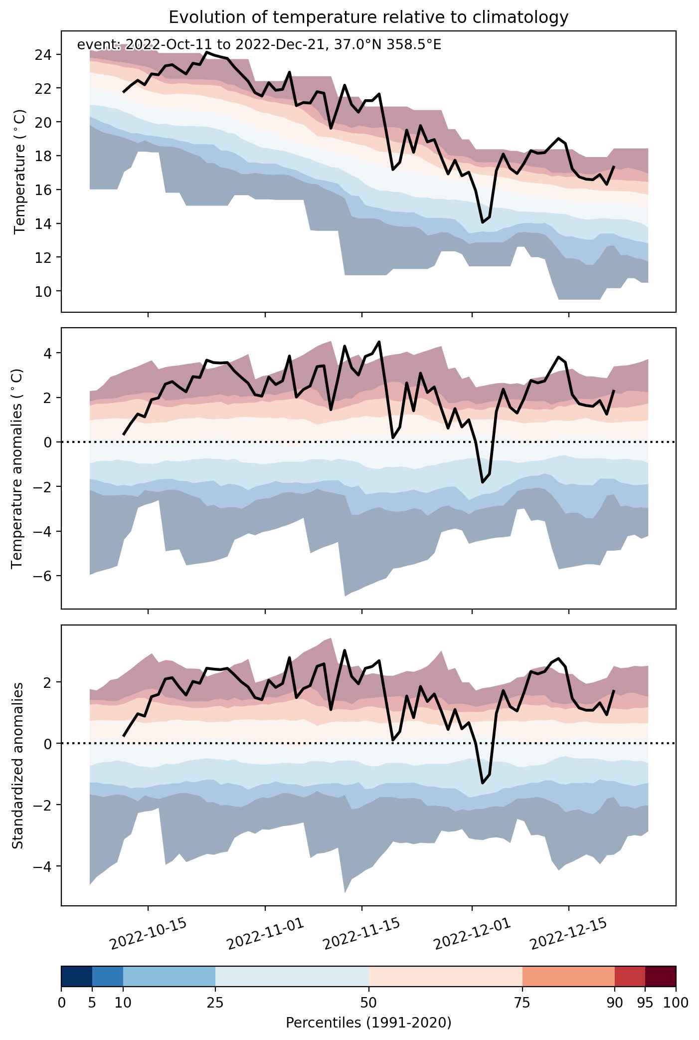
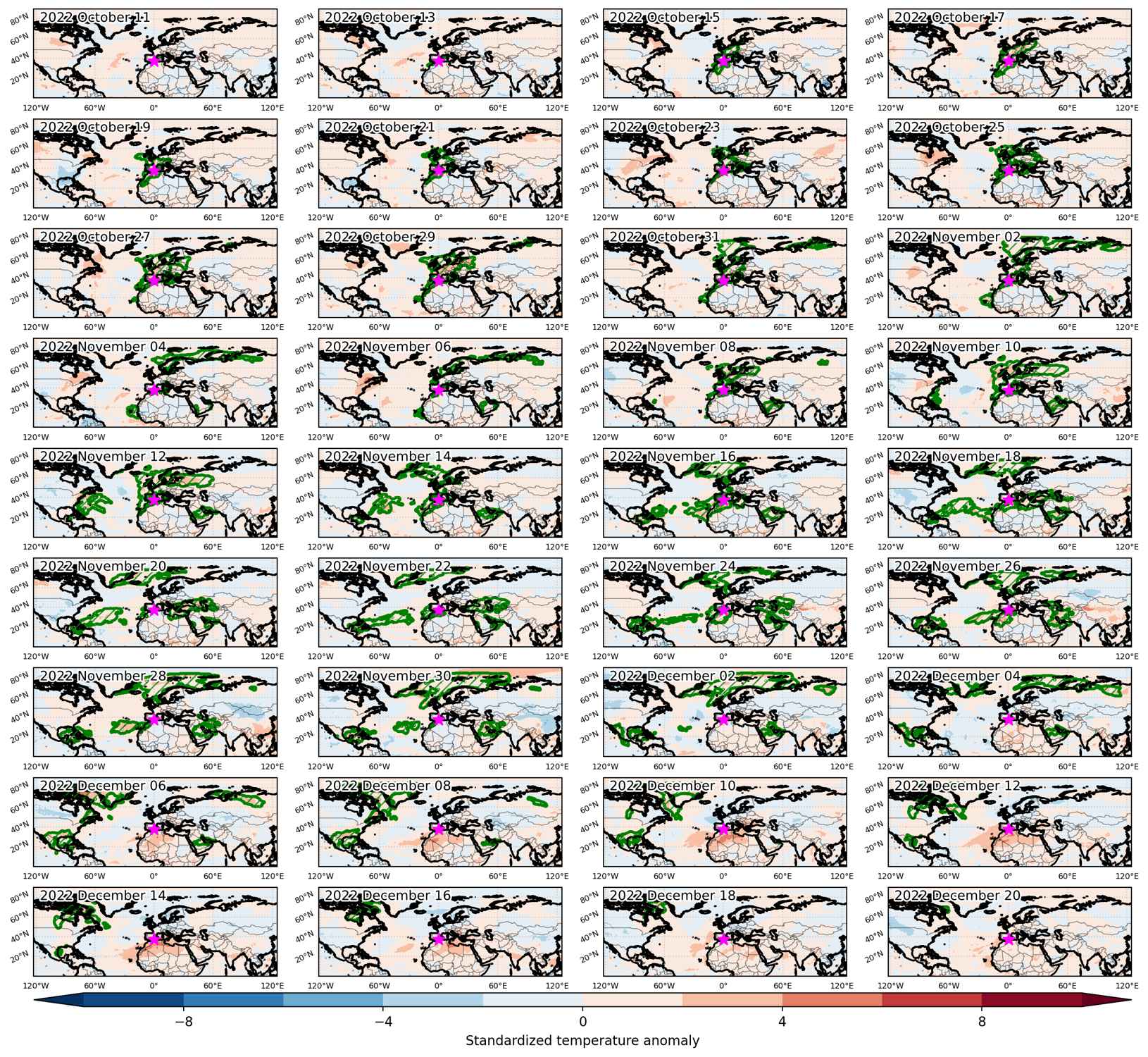
Heat wave occuring from October 11 2022 to December 21 2022 at 37.0°N 358.5°E

Download data: JSON

Event type: Heat wave

Countries affected (identified with ArcGIS Online; provided only for geographical reference):

  • Afghanistan
  • Albania
  • Algeria
  • Andorra
  • Armenia
  • Austria
  • Azerbaijan
  • Bahamas
  • Bahrain
  • Belarus
  • Belgium
  • Belize
  • Bosnia and Herzegovina
  • Bulgaria
  • Cabo Verde
  • Canada
  • Croatia
  • Cuba
  • Czechia
  • Denmark
  • Dominican Republic
  • Egypt
  • Estonia
  • Finland
  • France
  • Georgia
  • Germany
  • Greece
  • Greenland
  • Guatemala
  • Guinea-Bissau
  • Haiti
  • Honduras
  • Iceland
  • Iran, Islamic Republic of
  • Iraq
  • Ireland
  • Italy
  • Jamaica
  • Kazakhstan
  • Kuwait
  • Latvia
  • Libya
  • Lithuania
  • Luxembourg
  • Mali
  • Mauritania
  • Mexico
  • Montenegro
  • Morocco
  • Netherlands
  • Nicaragua
  • North Macedonia
  • Norway
  • Oman
  • Pakistan
  • Poland
  • Portugal
  • Qatar
  • Romania
  • Russian Federation
  • Saudi Arabia
  • Serbia
  • Slovakia
  • Slovenia
  • Spain
  • Svalbard and Jan Mayen
  • Sweden
  • Switzerland
  • Syrian Arab Republic
  • Tunisia
  • Turkmenistan
  • Turks and Caicos Islands
  • Türkiye
  • Ukraine
  • United Arab Emirates
  • United Kingdom
  • United States
  • Uzbekistan
  • Yemen

Duration: 72 days

Time span: October 11 2022 to December 21 2022

Statistics over entire affected area:

  • Mean temperature anomaly: 6.0 °C
  • Mean temperature: 9.6 °C
  • Maximum temperature anomaly: 25.8 °C
  • Maximum temperature: 30.8 °C

Event center: 37.5°N 0.0°E

Area affected: 51591959 km$^2$


Fig. 1: Map of most extreme temperature anomalies (standardized) experienced during the event. The purple star indicates the center of the extreme event. Green hatching illustrates all areas under the effect of extremes at some time during the event.


Fig. 2: Evolution of temperature at the center of the event. The climatological percentile distribution is illustrated with color shadings.


Fig. 3: Maps illustrating the evolution of standardized temperature anomalies during the event.

Event ID: Heat_wave_2022-Oct-11_to_2022-Dec-21_358.5_37.0

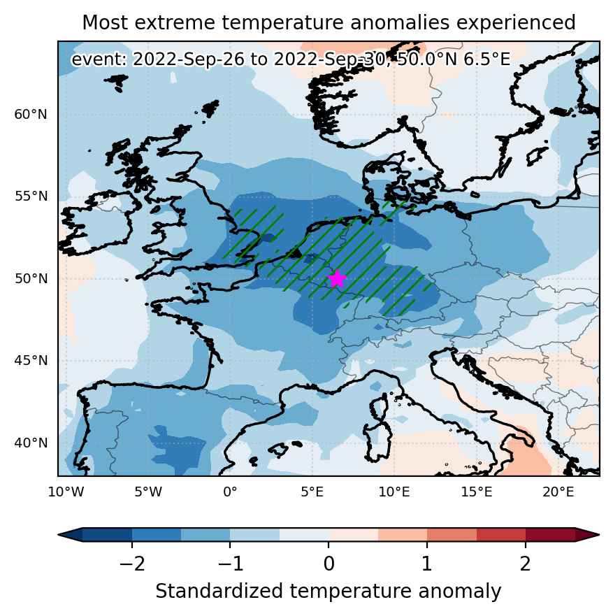
Cold spell occuring from September 26 2022 to September 30 2022 at 50.0°N 6.5°E

Download data: JSON

Event type: Cold spell

Countries affected (identified with ArcGIS Online; provided only for geographical reference):

  • Belgium
  • France
  • Germany
  • Luxembourg
  • Netherlands
  • United Kingdom

Duration: 5 days

Time span: September 26 2022 to September 30 2022

Statistics over entire affected area:

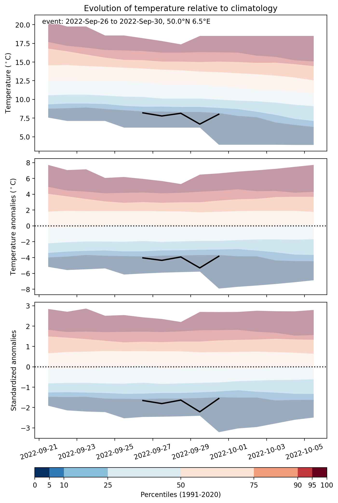
  • Mean temperature anomaly: -3.8 °C
  • Mean temperature: 9.4 °C
  • Minimum temperature anomaly: -5.4 °C
  • Minimum temperature: 6.4 °C

Event center: 50.0°N 6.5°E

Area affected: 365829 km$^2$


Fig. 1: Map of most extreme temperature anomalies (standardized) experienced during the event. The purple star indicates the center of the extreme event. Green hatching illustrates all areas under the effect of extremes at some time during the event.


Fig. 2: Evolution of temperature at the center of the event. The climatological percentile distribution is illustrated with color shadings.


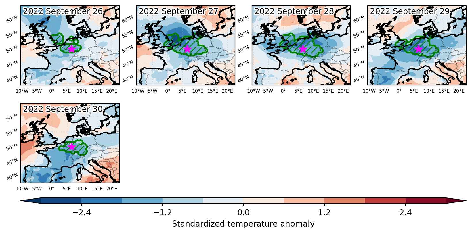
Fig. 3: Maps illustrating the evolution of standardized temperature anomalies during the event.

Event ID: Cold_spell_2022-Sep-26_to_2022-Sep-30_6.5_50.0

Heat wave occuring from April 12 2022 to April 18 2022 at 44.5°N 6.5°E

Download data: JSON

Event type: Heat wave

Countries affected (identified with ArcGIS Online; provided only for geographical reference):

  • Austria
  • France
  • Germany
  • Italy
  • Spain
  • Switzerland

Duration: 7 days

Time span: April 12 2022 to April 18 2022

Statistics over entire affected area:

  • Mean temperature anomaly: 5.2 °C
  • Mean temperature: 13.5 °C
  • Maximum temperature anomaly: 8.9 °C
  • Maximum temperature: 22.0 °C

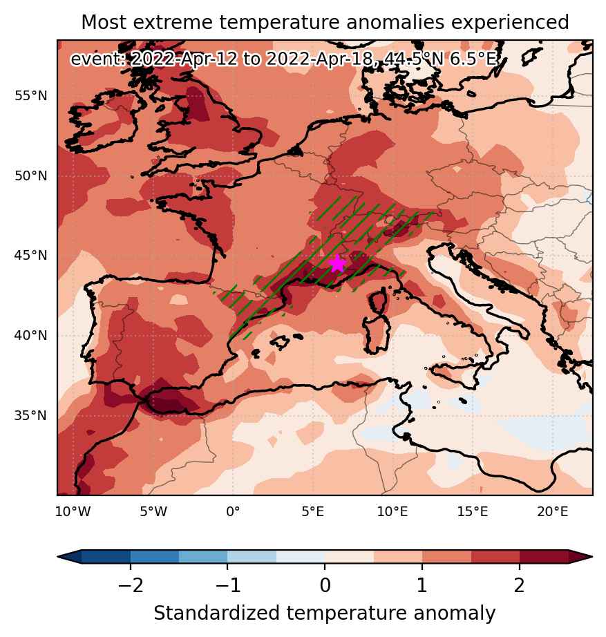
Event center: 44.5°N 6.5°E

Area affected: 310556 km$^2$


Fig. 1: Map of most extreme temperature anomalies (standardized) experienced during the event. The purple star indicates the center of the extreme event. Green hatching illustrates all areas under the effect of extremes at some time during the event.


Fig. 2: Evolution of temperature at the center of the event. The climatological percentile distribution is illustrated with color shadings.


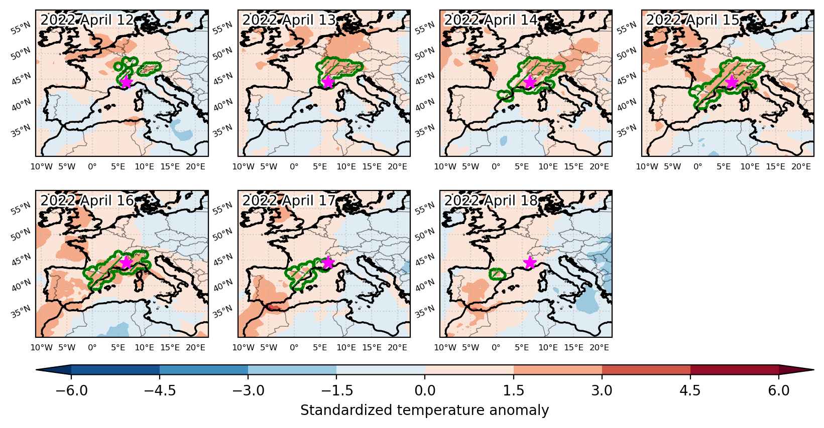
Fig. 3: Maps illustrating the evolution of standardized temperature anomalies during the event.

Event ID: Heat_wave_2022-Apr-12_to_2022-Apr-18_6.5_44.5

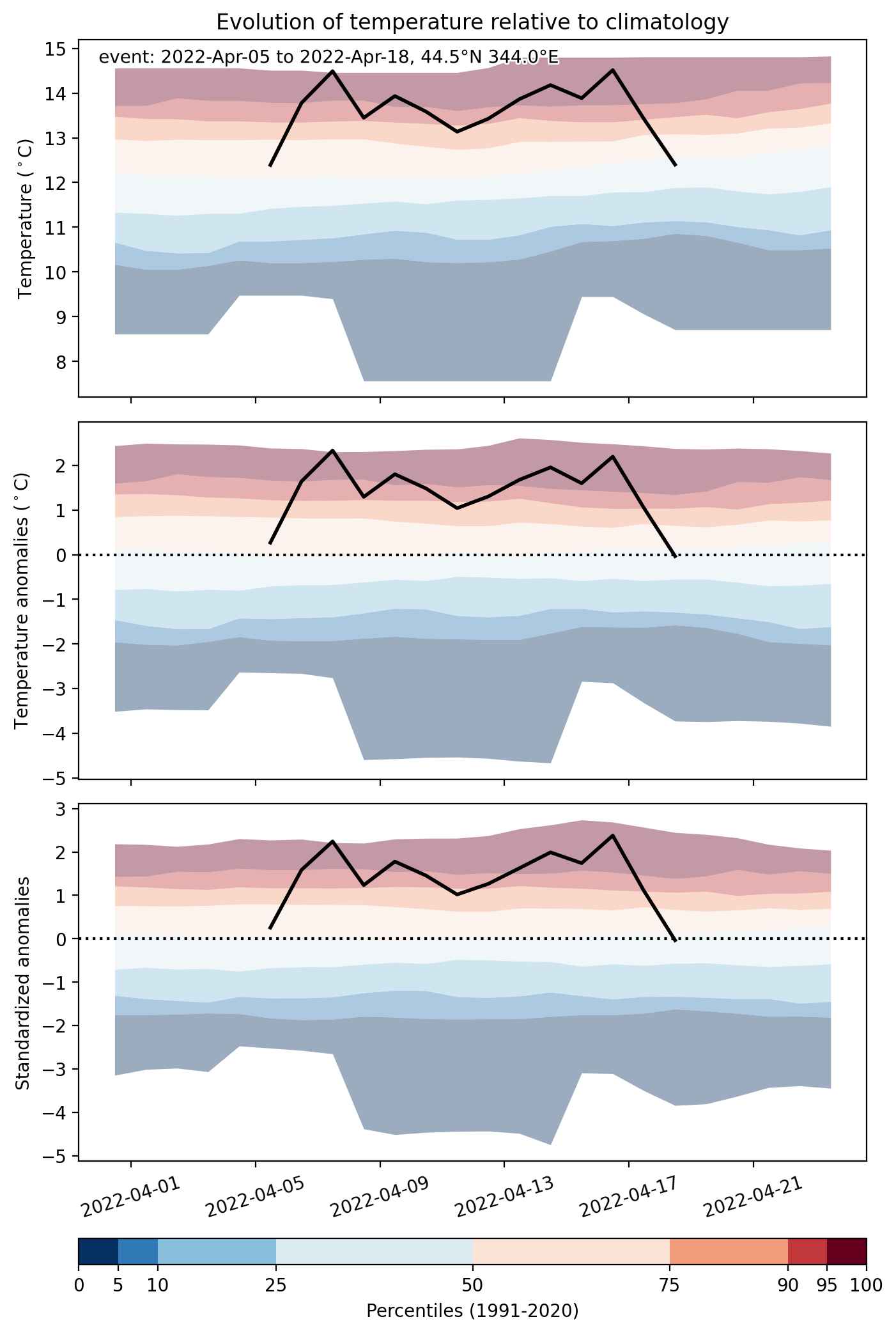
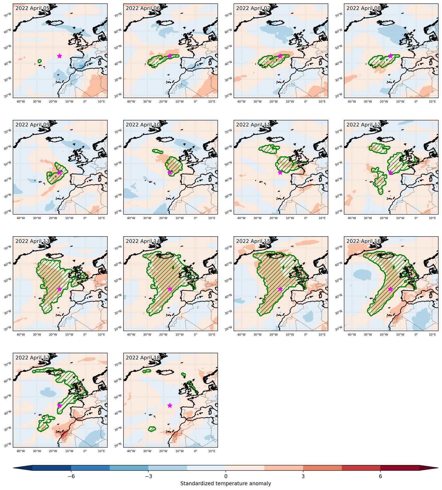
Heat wave occuring from April 05 2022 to April 18 2022 at 44.5°N 344.0°E

Download data: JSON

Event type: Heat wave

Countries affected (identified with ArcGIS Online; provided only for geographical reference):

  • France
  • Iceland
  • Ireland
  • Portugal
  • United Kingdom

Duration: 14 days

Time span: April 05 2022 to April 18 2022

Statistics over entire affected area:

  • Mean temperature anomaly: 2.3 °C
  • Mean temperature: 12.2 °C
  • Maximum temperature anomaly: 8.5 °C
  • Maximum temperature: 19.9 °C

Event center: 44.5°N 344.0°E

Area affected: 4679805 km$^2$


Fig. 1: Map of most extreme temperature anomalies (standardized) experienced during the event. The purple star indicates the center of the extreme event. Green hatching illustrates all areas under the effect of extremes at some time during the event.


Fig. 2: Evolution of temperature at the center of the event. The climatological percentile distribution is illustrated with color shadings.


Fig. 3: Maps illustrating the evolution of standardized temperature anomalies during the event.

Event ID: Heat_wave_2022-Apr-05_to_2022-Apr-18_344.0_44.5

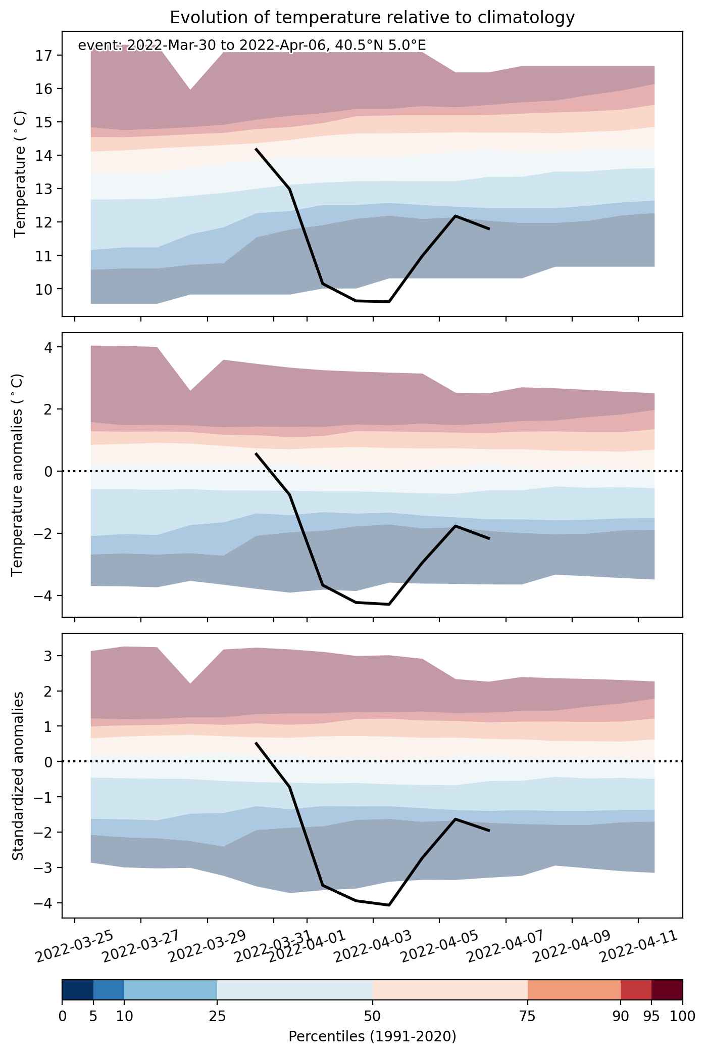
Cold spell occuring from March 30 2022 to April 06 2022 at 40.5°N 5.0°E

Download data: JSON

Event type: Cold spell

Countries affected (identified with ArcGIS Online; provided only for geographical reference):

  • Algeria
  • Andorra
  • Austria
  • Belarus
  • Belgium
  • Bosnia and Herzegovina
  • Croatia
  • Czechia
  • France
  • Germany
  • Hungary
  • Italy
  • Luxembourg
  • Morocco
  • Netherlands
  • Poland
  • Portugal
  • Romania
  • Serbia
  • Slovakia
  • Slovenia
  • Spain
  • Switzerland
  • Ukraine
  • United Kingdom

Duration: 8 days

Time span: March 30 2022 to April 06 2022

Statistics over entire affected area:

  • Mean temperature anomaly: -5.0 °C
  • Mean temperature: 5.2 °C
  • Minimum temperature anomaly: -10.1 °C
  • Minimum temperature: -11.5 °C

Event center: 40.5°N 5.0°E

Area affected: 3691737 km$^2$


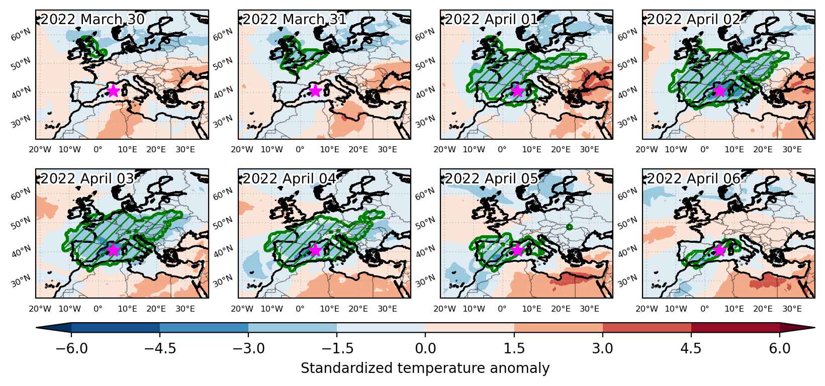
Fig. 1: Map of most extreme temperature anomalies (standardized) experienced during the event. The purple star indicates the center of the extreme event. Green hatching illustrates all areas under the effect of extremes at some time during the event.


Fig. 2: Evolution of temperature at the center of the event. The climatological percentile distribution is illustrated with color shadings.


Fig. 3: Maps illustrating the evolution of standardized temperature anomalies during the event.

Event ID: Cold_spell_2022-Mar-30_to_2022-Apr-06_5.0_40.5