Heat wave occuring from June 17 2014 to June 22 2014 at 8.0°N 279.0°E

Download data: JSON

Event type: Heat wave

Countries affected (identified with ArcGIS Online; provided only for geographical reference):

  • Panama

Duration: 6 days

Time span: June 17 2014 to June 22 2014

Statistics over entire affected area:

  • Mean temperature anomaly: 1.2 °C
  • Mean temperature: 27.4 °C
  • Maximum temperature anomaly: 2.2 °C
  • Maximum temperature: 29.0 °C

Event center: 8.0°N 279.0°E

Area affected: 58145 km$^2$
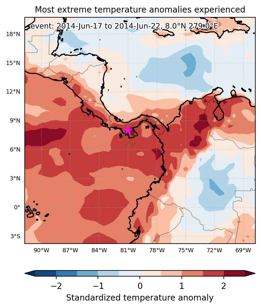

Fig. 1: Map of most extreme temperature anomalies (standardized) experienced during the event. The purple star indicates the center of the extreme event. Green hatching illustrates all areas under the effect of extremes at some time during the event.
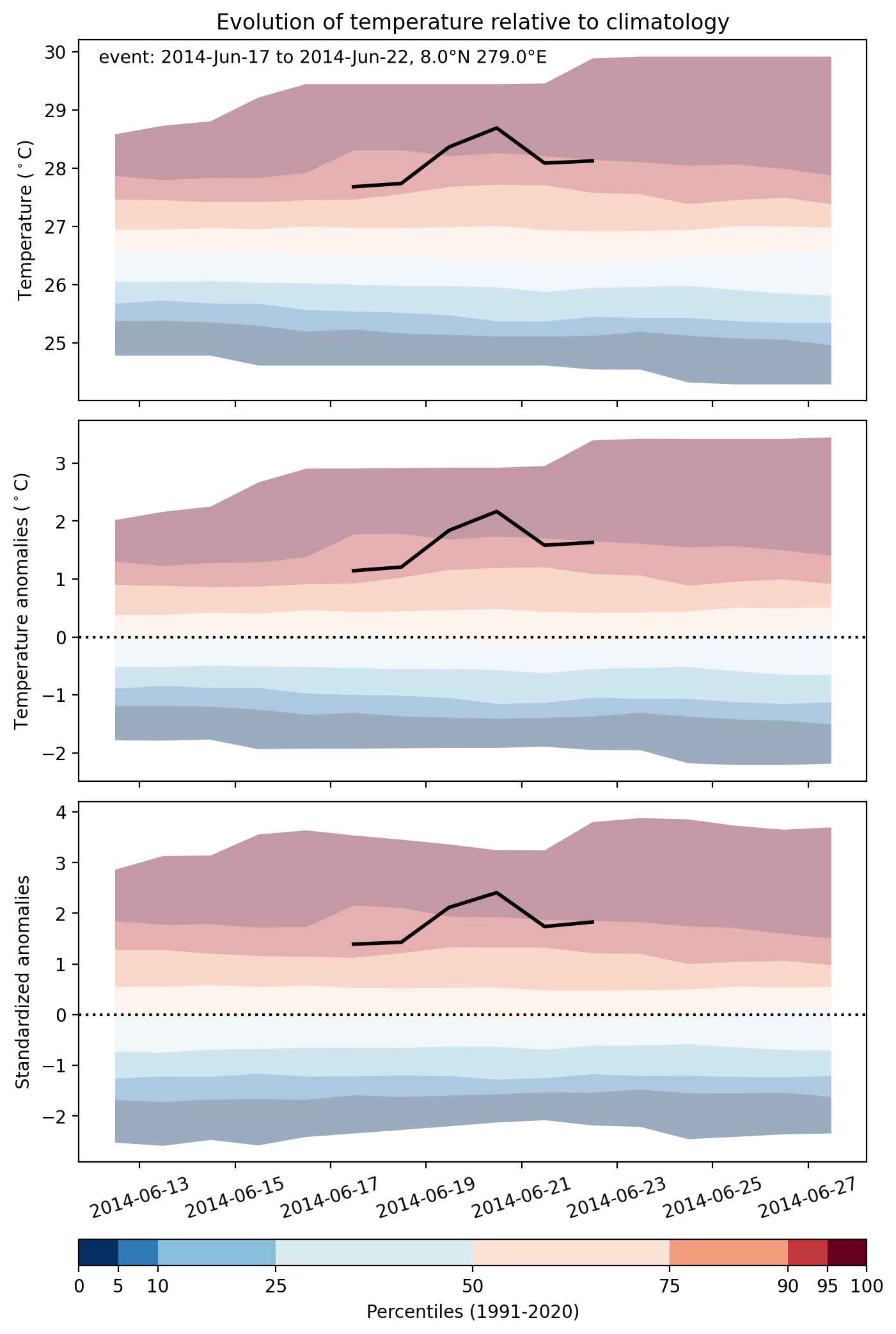


Fig. 2: Evolution of temperature at the center of the event. The climatological percentile distribution is illustrated with color shadings.
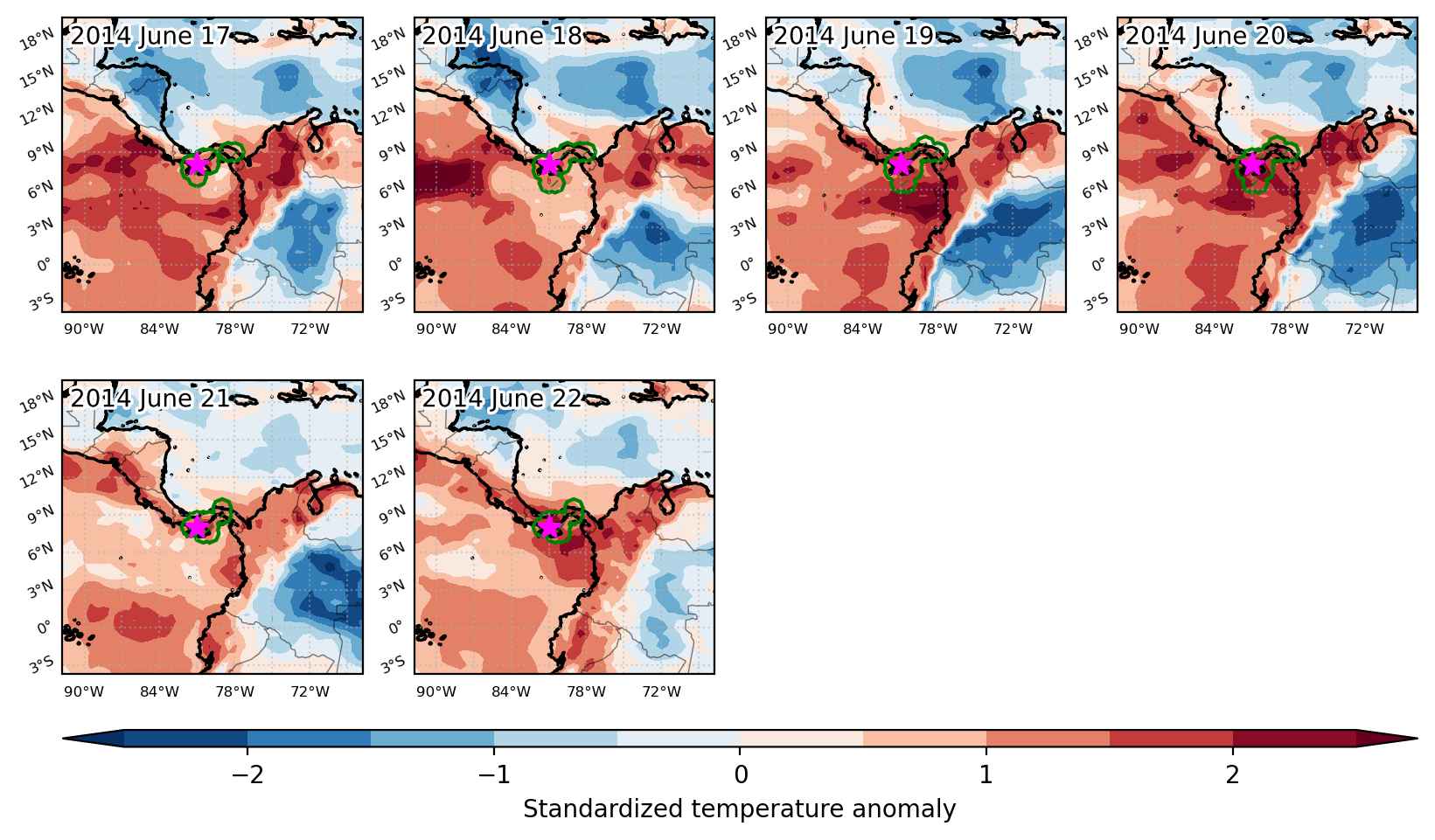


Fig. 3: Maps illustrating the evolution of standardized temperature anomalies during the event.

Event ID: Heat_wave_2014-Jun-17_to_2014-Jun-22_279.0_8.0
Heat wave occuring from April 06 2014 to November 06 2014 at 25.5°N 247.0°E

Download data: JSON

Event type: Heat wave

Countries affected (identified with ArcGIS Online; provided only for geographical reference):

  • Afghanistan
  • Bangladesh
  • Belize
  • Bhutan
  • Bolivia
  • Brazil
  • Cambodia
  • Canada
  • Chile
  • China
  • Colombia
  • Costa Rica
  • Cuba
  • Ecuador
  • El Salvador
  • Guatemala
  • Guyana
  • Honduras
  • India
  • Indonesia
  • Japan
  • Laos
  • Malaysia
  • Mexico
  • Mongolia
  • Myanmar
  • Nepal
  • Nicaragua
  • North Korea
  • Pakistan
  • Palau
  • Panama
  • Papua New Guinea
  • Paraguay
  • Peru
  • Philippines
  • Russian Federation
  • Solomon Islands
  • South Korea
  • Sri Lanka
  • Suriname
  • Thailand
  • United States
  • Venezuela
  • Vietnam

Duration: 215 days

Time span: April 06 2014 to November 06 2014

Statistics over entire affected area:

  • Mean temperature anomaly: 2.2 °C
  • Mean temperature: 22.1 °C
  • Maximum temperature anomaly: 14.8 °C
  • Maximum temperature: 39.7 °C

Event center: 25.5°N 247.0°E

Area affected: 104132475 km$^2$


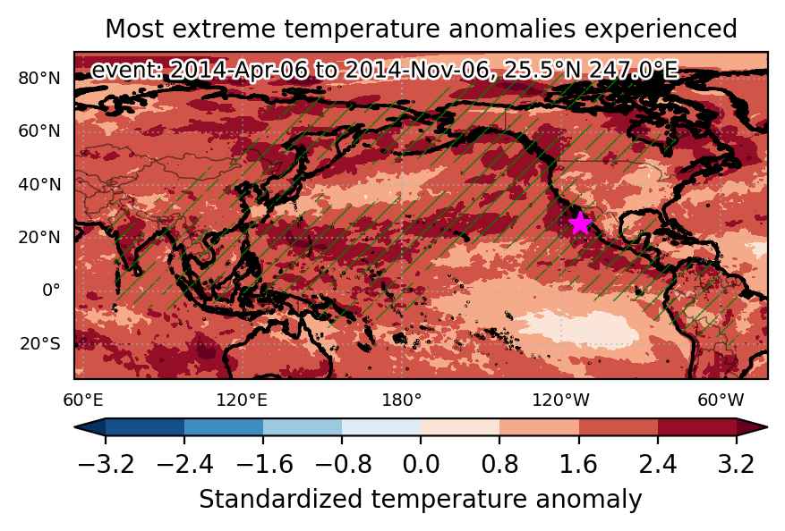
Fig. 1: Map of most extreme temperature anomalies (standardized) experienced during the event. The purple star indicates the center of the extreme event. Green hatching illustrates all areas under the effect of extremes at some time during the event.


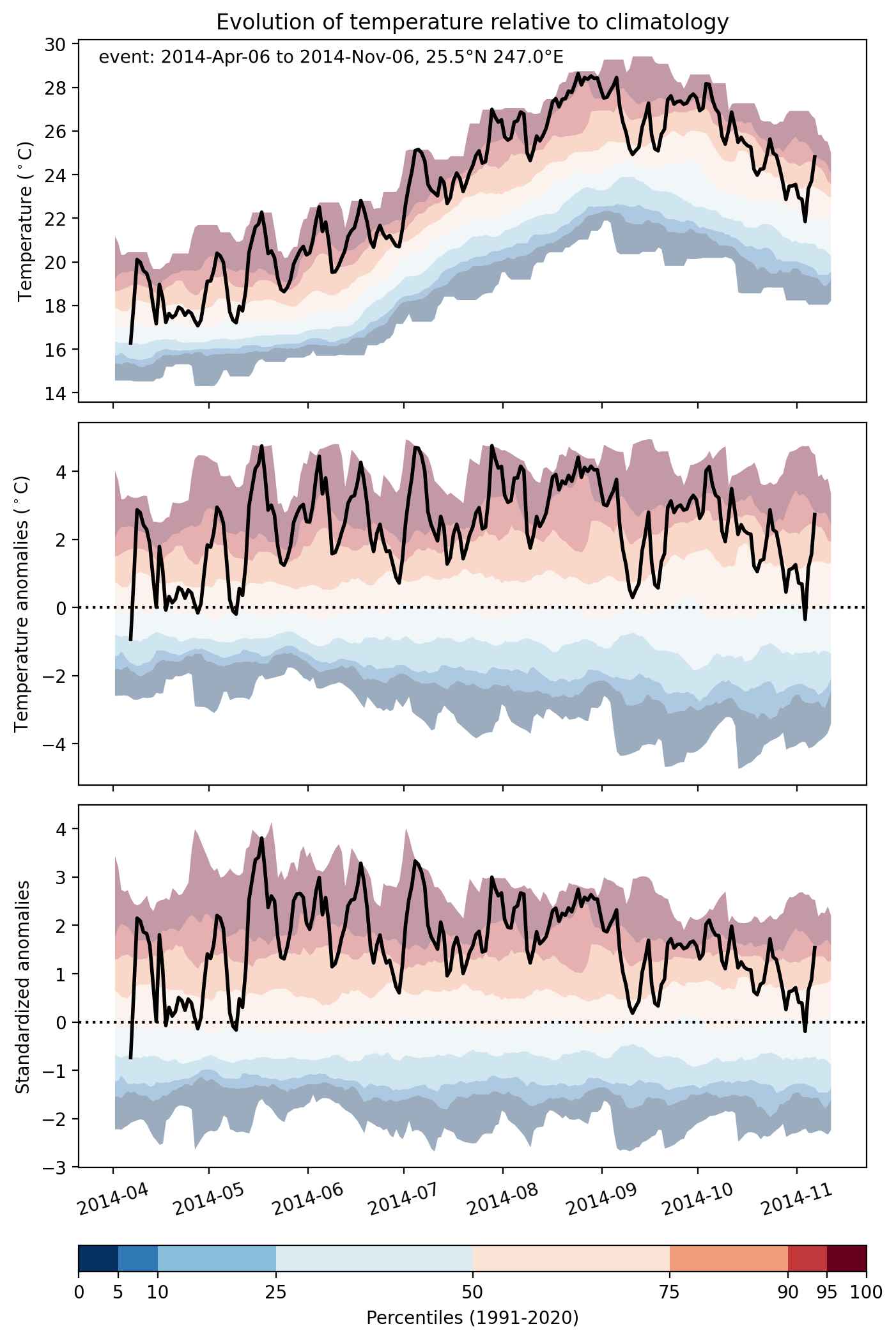
Fig. 2: Evolution of temperature at the center of the event. The climatological percentile distribution is illustrated with color shadings.


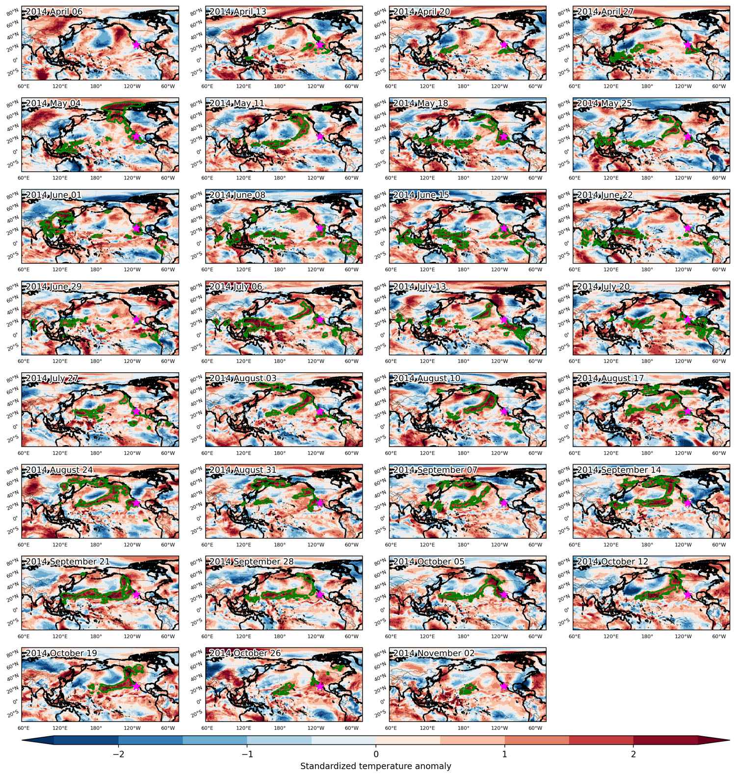
Fig. 3: Maps illustrating the evolution of standardized temperature anomalies during the event.

Event ID: Heat_wave_2014-Apr-06_to_2014-Nov-06_247.0_25.5

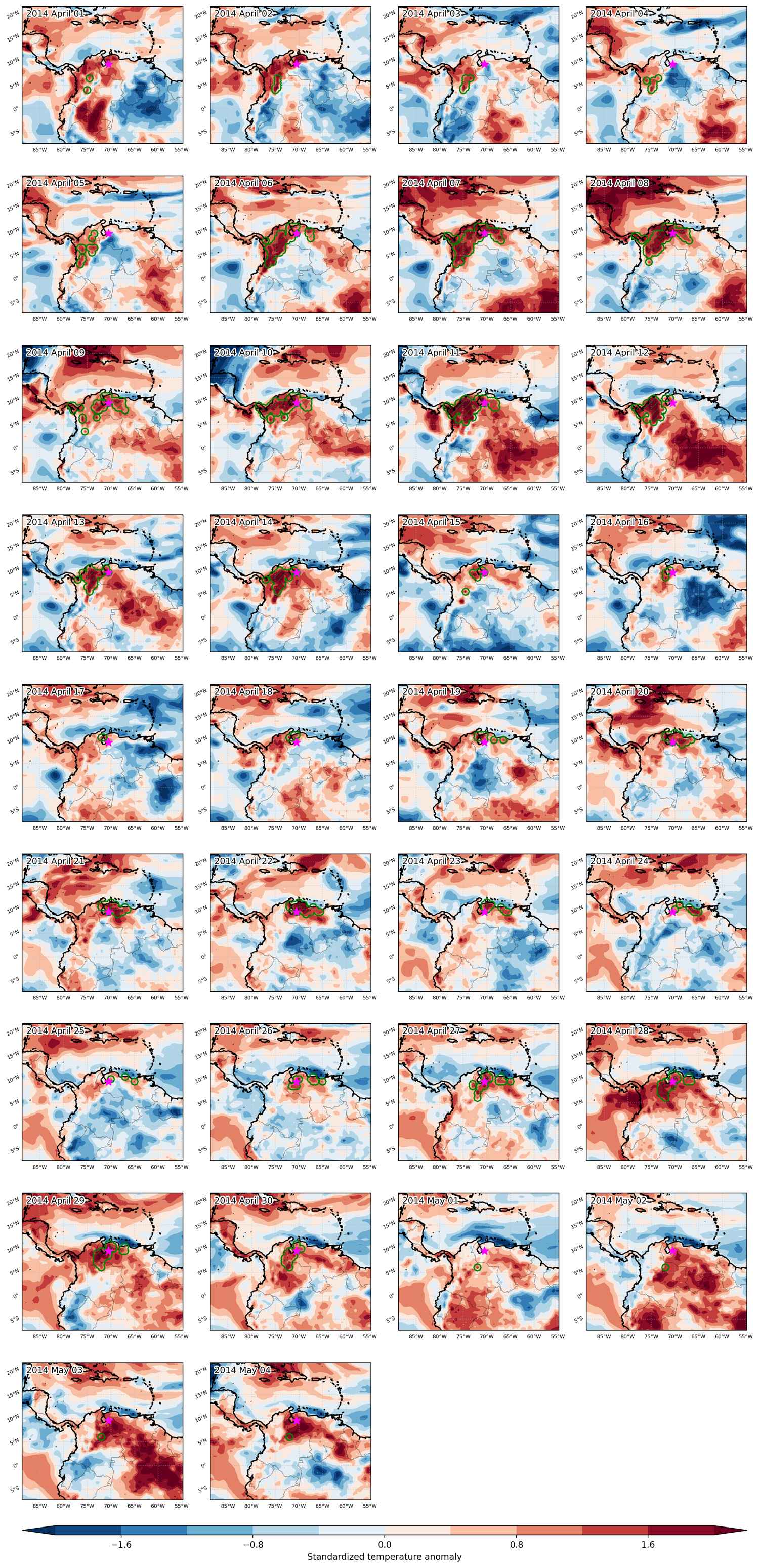
Heat wave occuring from April 01 2014 to May 04 2014 at 9.5°N 289.5°E

Download data: JSON

Event type: Heat wave

Countries affected (identified with ArcGIS Online; provided only for geographical reference):

  • Colombia
  • Panama
  • Venezuela

Duration: 34 days

Time span: April 01 2014 to May 04 2014

Statistics over entire affected area:

  • Mean temperature anomaly: 2.1 °C
  • Mean temperature: 27.8 °C
  • Maximum temperature anomaly: 4.2 °C
  • Maximum temperature: 34.2 °C

Event center: 9.5°N 289.5°E

Area affected: 434119 km$^2$


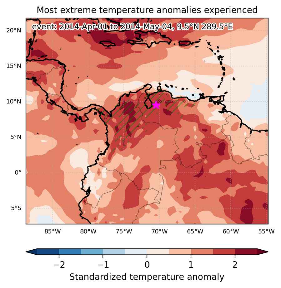
Fig. 1: Map of most extreme temperature anomalies (standardized) experienced during the event. The purple star indicates the center of the extreme event. Green hatching illustrates all areas under the effect of extremes at some time during the event.


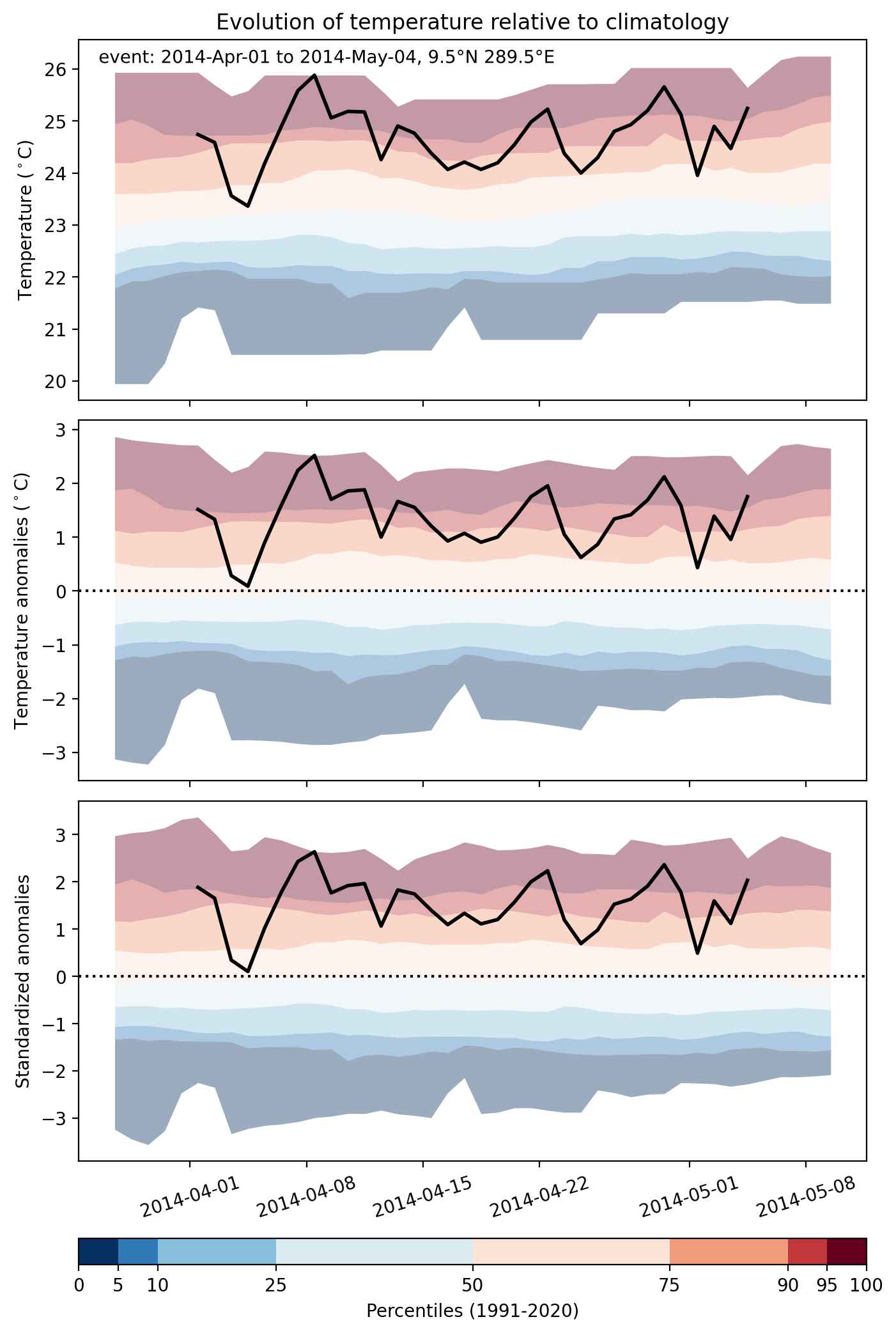
Fig. 2: Evolution of temperature at the center of the event. The climatological percentile distribution is illustrated with color shadings.


Fig. 3: Maps illustrating the evolution of standardized temperature anomalies during the event.

Event ID: Heat_wave_2014-Apr-01_to_2014-May-04_289.5_9.5

Heat wave occuring from March 27 2014 to April 04 2014 at 8.0°N 284.5°E

Download data: JSON

Event type: Heat wave

Countries affected (identified with ArcGIS Online; provided only for geographical reference):

  • Colombia
  • Panama

Duration: 9 days

Time span: March 27 2014 to April 04 2014

Statistics over entire affected area:

  • Mean temperature anomaly: 1.8 °C
  • Mean temperature: 28.8 °C
  • Maximum temperature anomaly: 3.3 °C
  • Maximum temperature: 32.1 °C

Event center: 8.0°N 284.5°E

Area affected: 70382 km$^2$


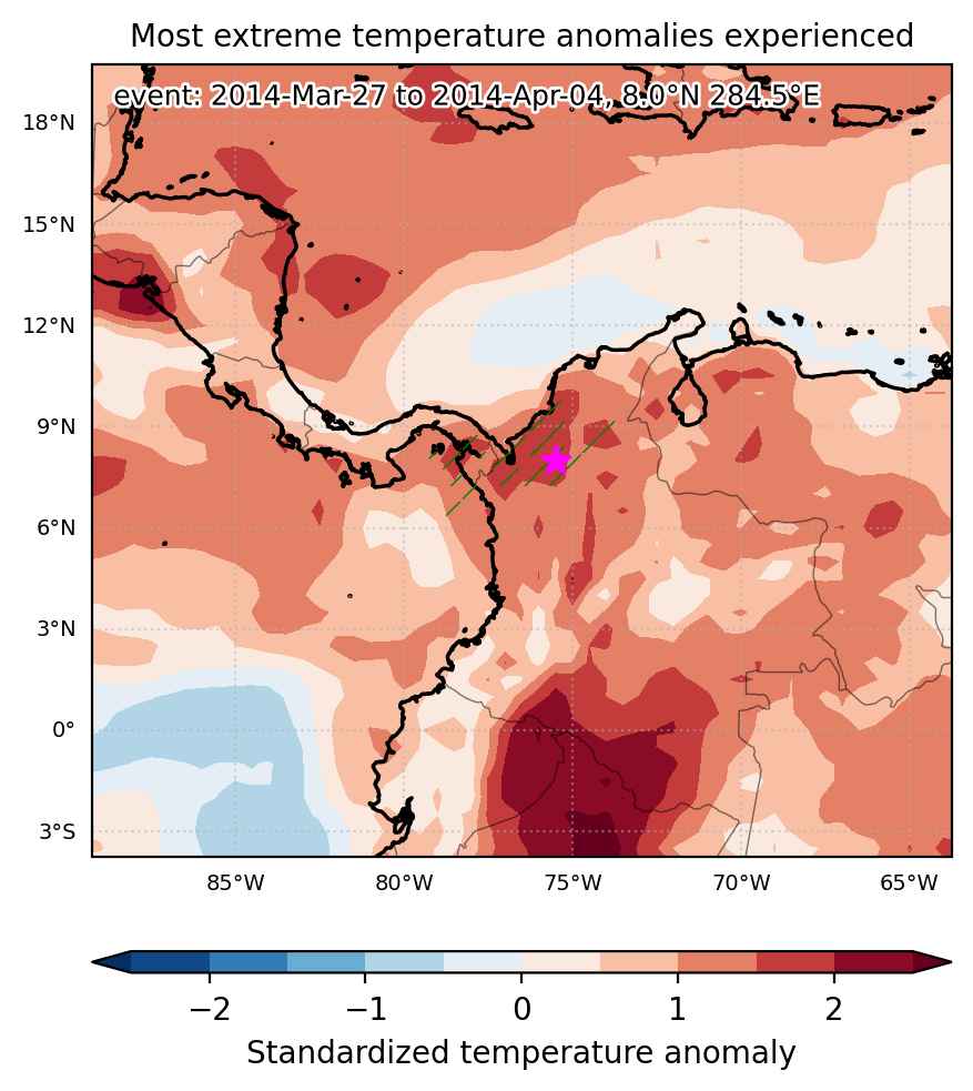
Fig. 1: Map of most extreme temperature anomalies (standardized) experienced during the event. The purple star indicates the center of the extreme event. Green hatching illustrates all areas under the effect of extremes at some time during the event.


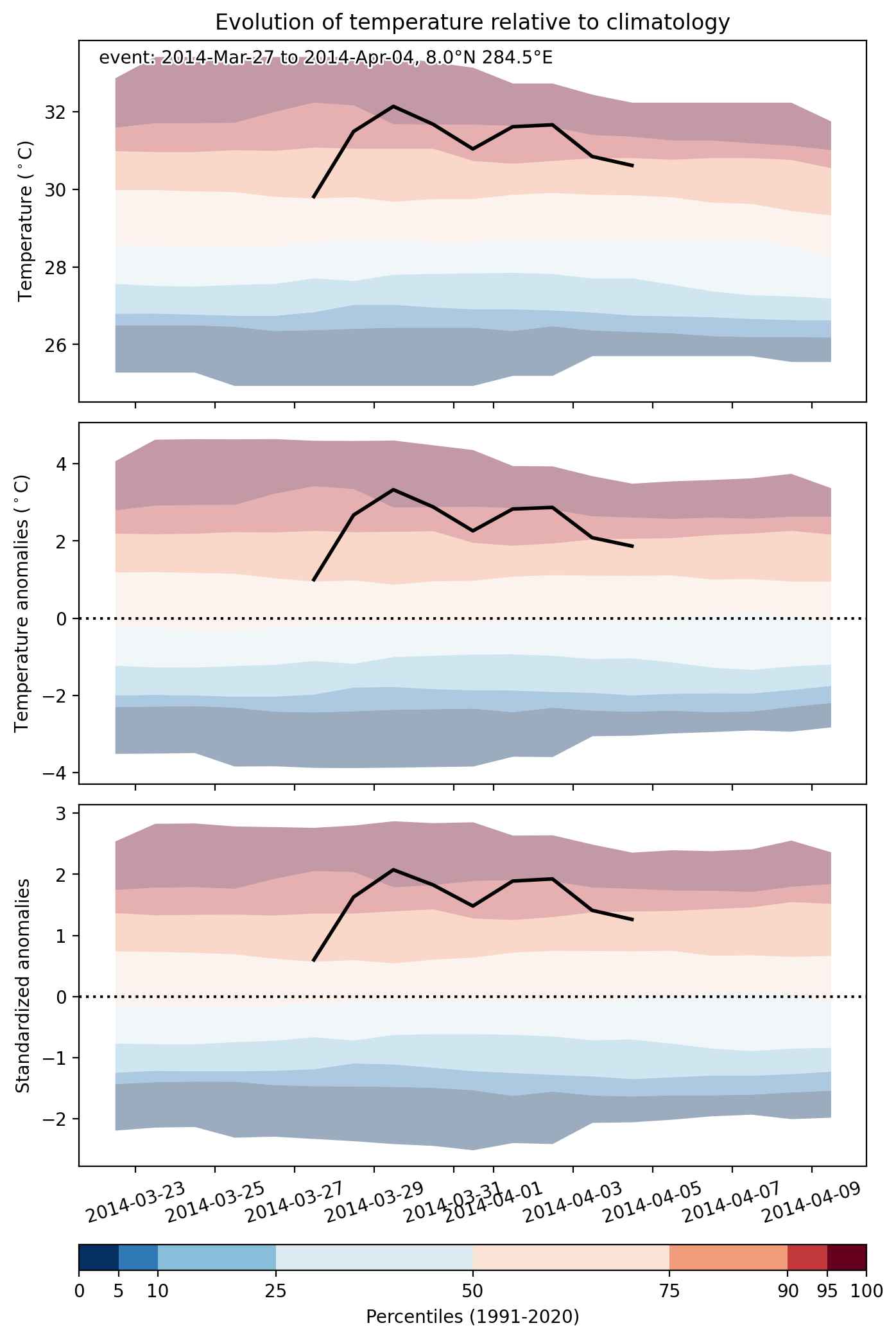
Fig. 2: Evolution of temperature at the center of the event. The climatological percentile distribution is illustrated with color shadings.


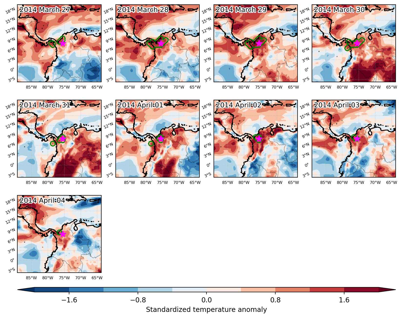
Fig. 3: Maps illustrating the evolution of standardized temperature anomalies during the event.

Event ID: Heat_wave_2014-Mar-27_to_2014-Apr-04_284.5_8.0

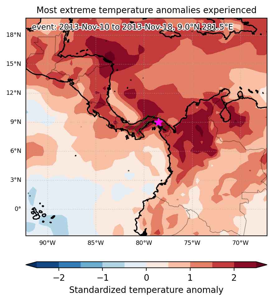
Heat wave occuring from November 10 2013 to November 18 2013 at 9.0°N 281.5°E

Download data: JSON

Event type: Heat wave

Countries affected (identified with ArcGIS Online; provided only for geographical reference):

  • Panama

Duration: 9 days

Time span: November 10 2013 to November 18 2013

Statistics over entire affected area:

  • Mean temperature anomaly: 1.1 °C
  • Mean temperature: 26.2 °C
  • Maximum temperature anomaly: 1.9 °C
  • Maximum temperature: 27.9 °C

Event center: 9.0°N 281.5°E

Area affected: 67217 km$^2$


Fig. 1: Map of most extreme temperature anomalies (standardized) experienced during the event. The purple star indicates the center of the extreme event. Green hatching illustrates all areas under the effect of extremes at some time during the event.


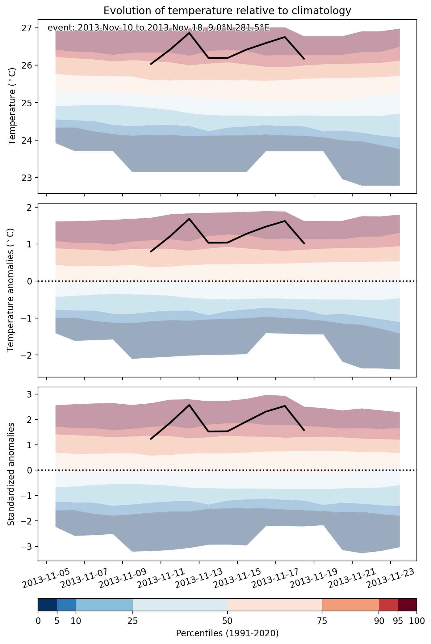
Fig. 2: Evolution of temperature at the center of the event. The climatological percentile distribution is illustrated with color shadings.


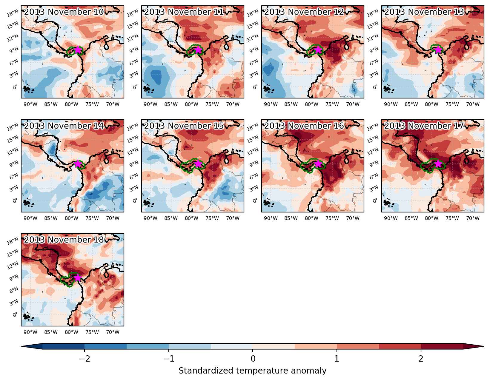
Fig. 3: Maps illustrating the evolution of standardized temperature anomalies during the event.

Event ID: Heat_wave_2013-Nov-10_to_2013-Nov-18_281.5_9.0

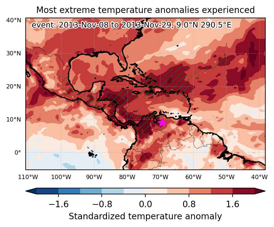
Heat wave occuring from November 08 2013 to November 29 2013 at 9.0°N 290.5°E

Download data: JSON

Event type: Heat wave

Countries affected (identified with ArcGIS Online; provided only for geographical reference):

  • Bahamas
  • Belize
  • Colombia
  • Costa Rica
  • Dominican Republic
  • El Salvador
  • Guatemala
  • Haiti
  • Honduras
  • Jamaica
  • Mexico
  • Nicaragua
  • Panama
  • Puerto Rico
  • Saint Eustatius
  • Turks and Caicos Islands
  • Venezuela

Duration: 22 days

Time span: November 08 2013 to November 29 2013

Statistics over entire affected area:

  • Mean temperature anomaly: 1.5 °C
  • Mean temperature: 26.2 °C
  • Maximum temperature anomaly: 5.3 °C
  • Maximum temperature: 30.2 °C

Event center: 9.0°N 290.5°E

Area affected: 2993905 km$^2$


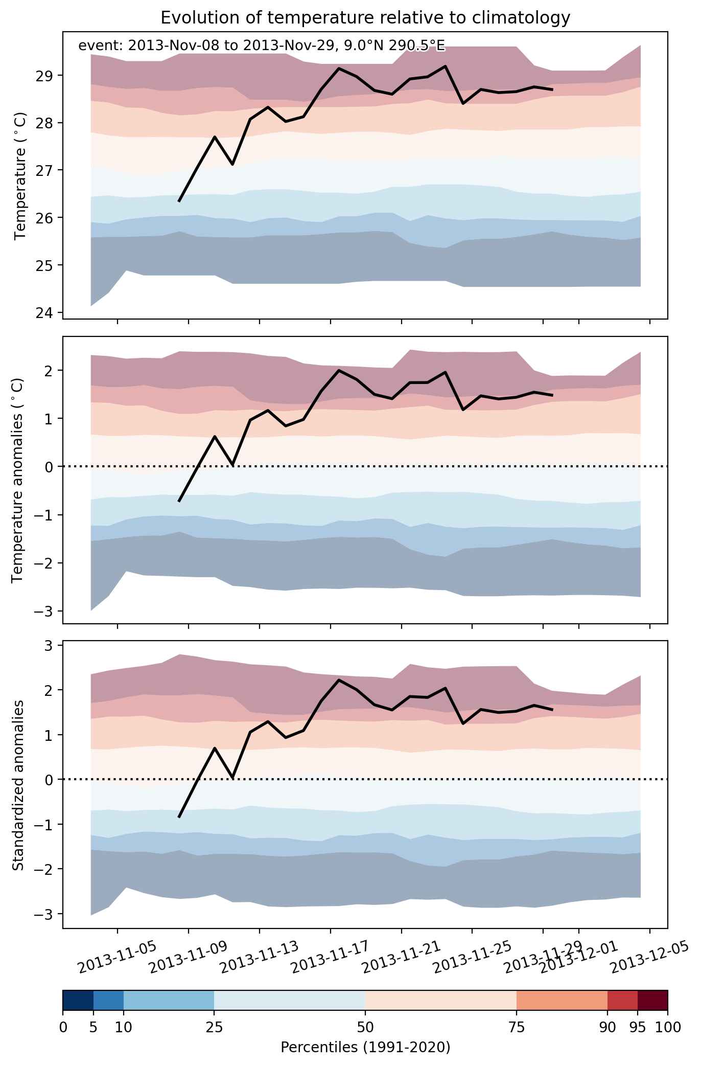
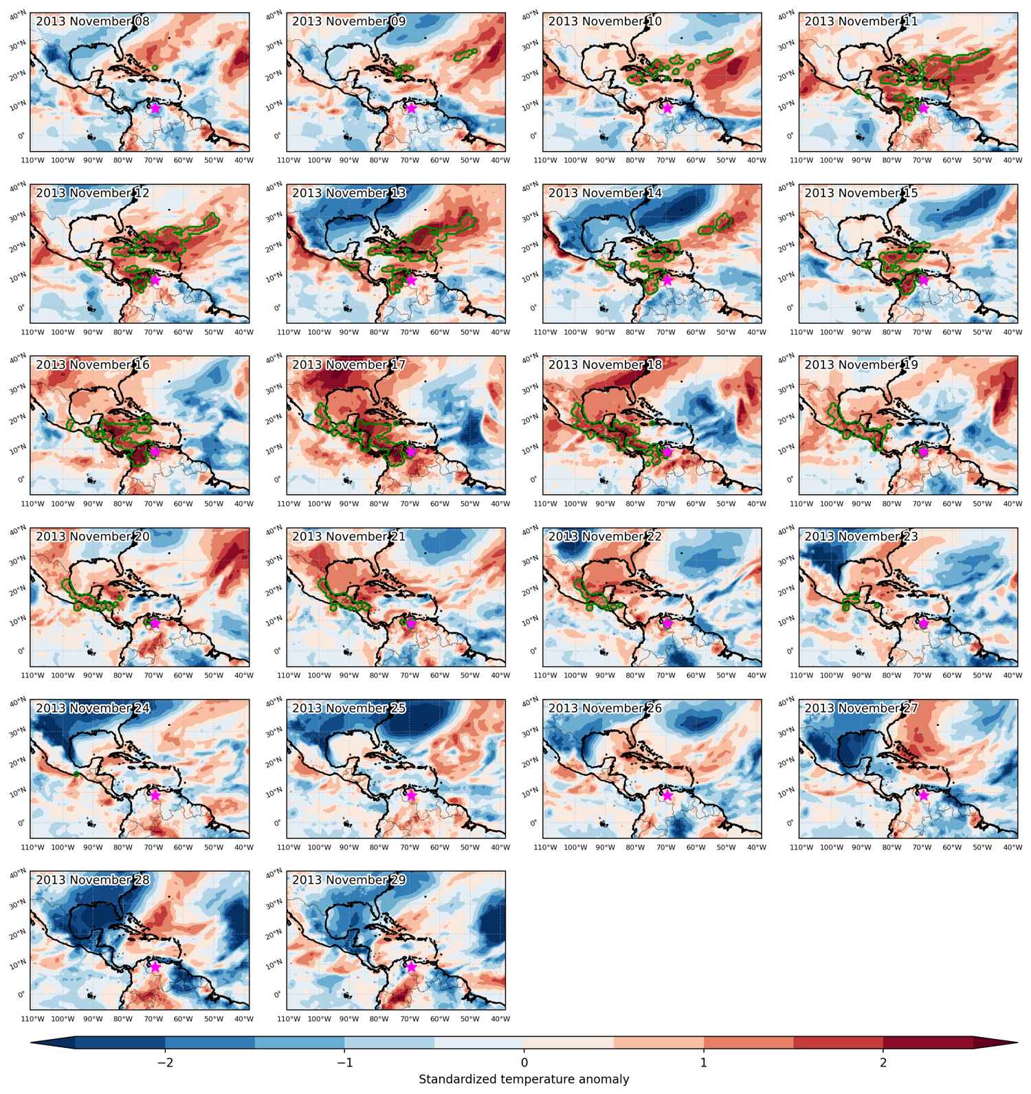
Fig. 1: Map of most extreme temperature anomalies (standardized) experienced during the event. The purple star indicates the center of the extreme event. Green hatching illustrates all areas under the effect of extremes at some time during the event.


Fig. 2: Evolution of temperature at the center of the event. The climatological percentile distribution is illustrated with color shadings.


Fig. 3: Maps illustrating the evolution of standardized temperature anomalies during the event.

Event ID: Heat_wave_2013-Nov-08_to_2013-Nov-29_290.5_9.0

Heat wave occuring from September 12 2013 to September 29 2013 at 7.5°N 298.0°E

Download data: JSON

Event type: Heat wave

Countries affected (identified with ArcGIS Online; provided only for geographical reference):

  • Aruba
  • Bahamas
  • Colombia
  • Costa Rica
  • Cuba
  • Dominican Republic
  • Haiti
  • Panama
  • Puerto Rico
  • Turks and Caicos Islands
  • Venezuela

Duration: 18 days

Time span: September 12 2013 to September 29 2013

Statistics over entire affected area:

  • Mean temperature anomaly: 1.3 °C
  • Mean temperature: 28.2 °C
  • Maximum temperature anomaly: 4.0 °C
  • Maximum temperature: 32.5 °C

Event center: 7.5°N 298.0°E

Area affected: 2448422 km$^2$


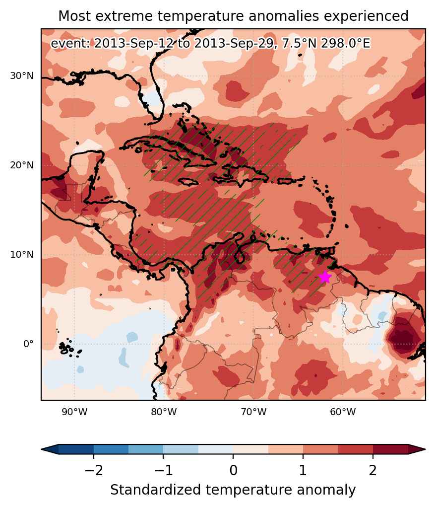
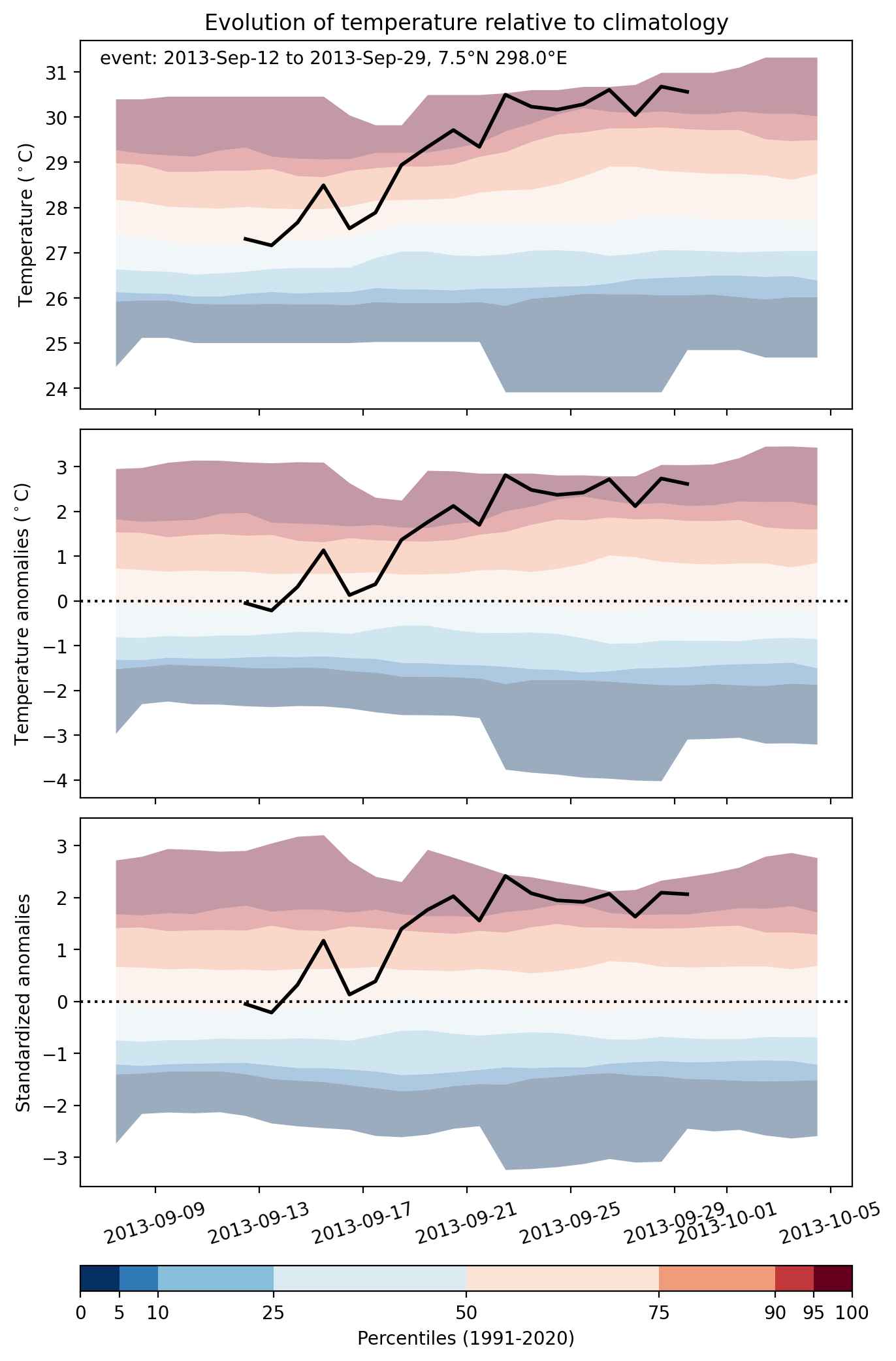
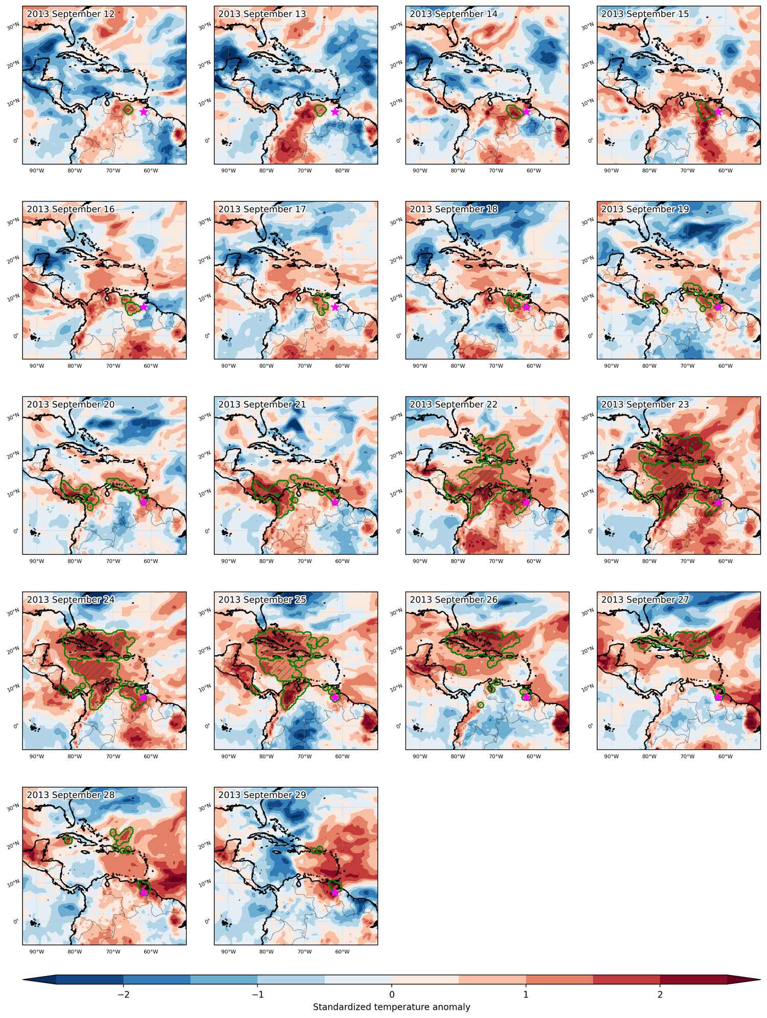
Fig. 1: Map of most extreme temperature anomalies (standardized) experienced during the event. The purple star indicates the center of the extreme event. Green hatching illustrates all areas under the effect of extremes at some time during the event.


Fig. 2: Evolution of temperature at the center of the event. The climatological percentile distribution is illustrated with color shadings.


Fig. 3: Maps illustrating the evolution of standardized temperature anomalies during the event.

Event ID: Heat_wave_2013-Sep-12_to_2013-Sep-29_298.0_7.5

Cold spell occuring from April 18 2013 to April 22 2013 at 7.5°N 280.0°E

Download data: JSON

Event type: Cold spell

Countries affected (identified with ArcGIS Online; provided only for geographical reference):

  • Costa Rica
  • Panama

Duration: 5 days

Time span: April 18 2013 to April 22 2013

Statistics over entire affected area:

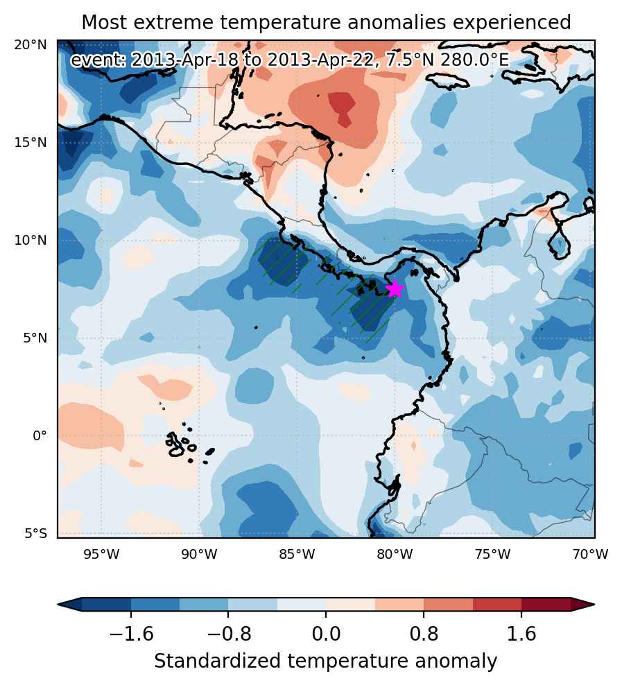
  • Mean temperature anomaly: -1.0 °C
  • Mean temperature: 26.1 °C
  • Minimum temperature anomaly: -2.1 °C
  • Minimum temperature: 23.1 °C

Event center: 7.5°N 280.0°E

Area affected: 183779 km$^2$


Fig. 1: Map of most extreme temperature anomalies (standardized) experienced during the event. The purple star indicates the center of the extreme event. Green hatching illustrates all areas under the effect of extremes at some time during the event.


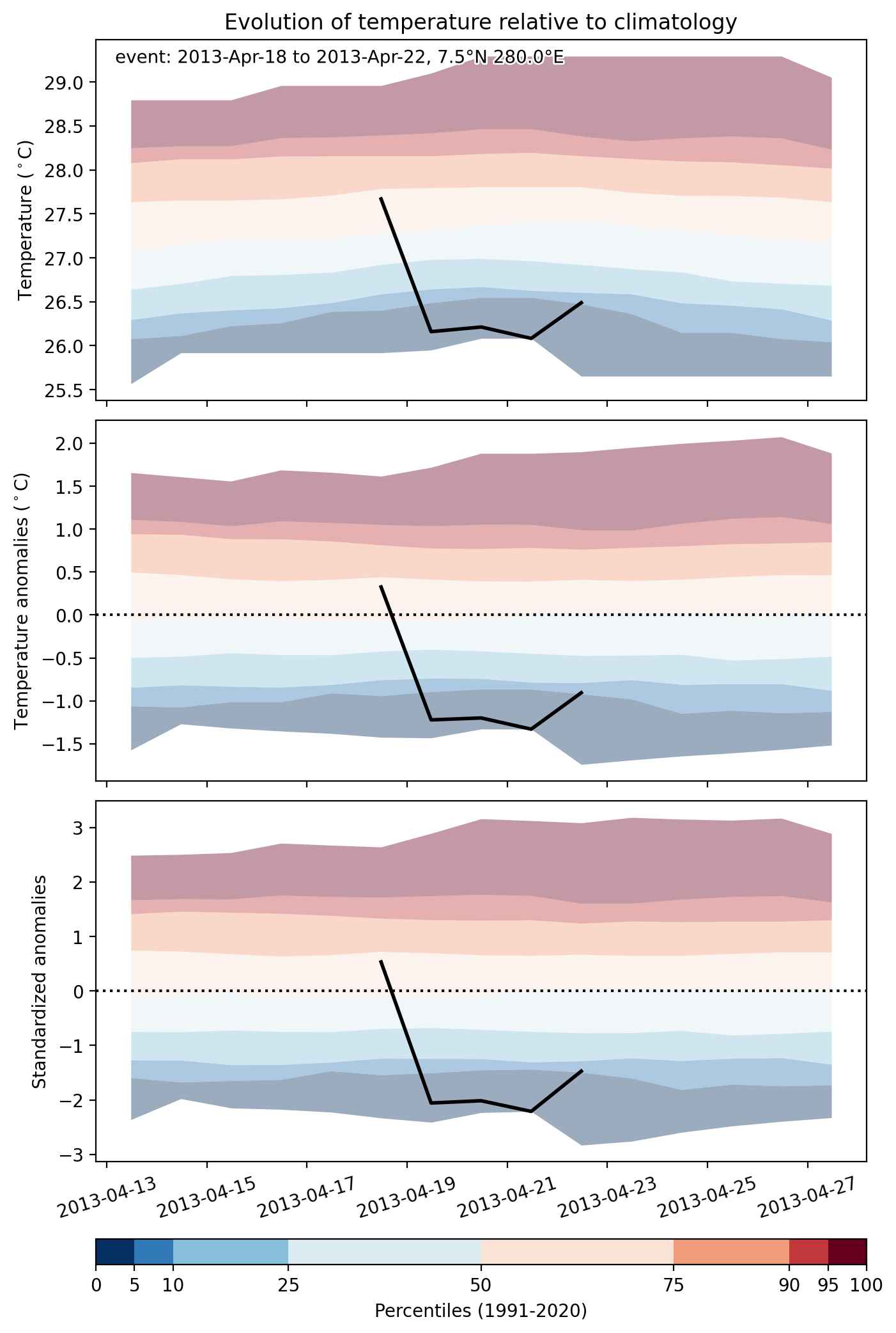
Fig. 2: Evolution of temperature at the center of the event. The climatological percentile distribution is illustrated with color shadings.


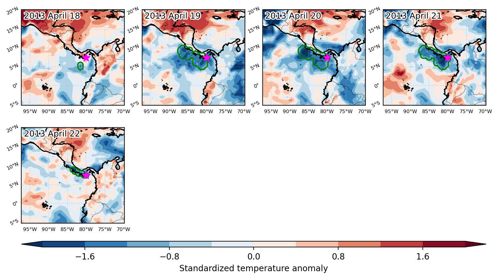
Fig. 3: Maps illustrating the evolution of standardized temperature anomalies during the event.

Event ID: Cold_spell_2013-Apr-18_to_2013-Apr-22_280.0_7.5

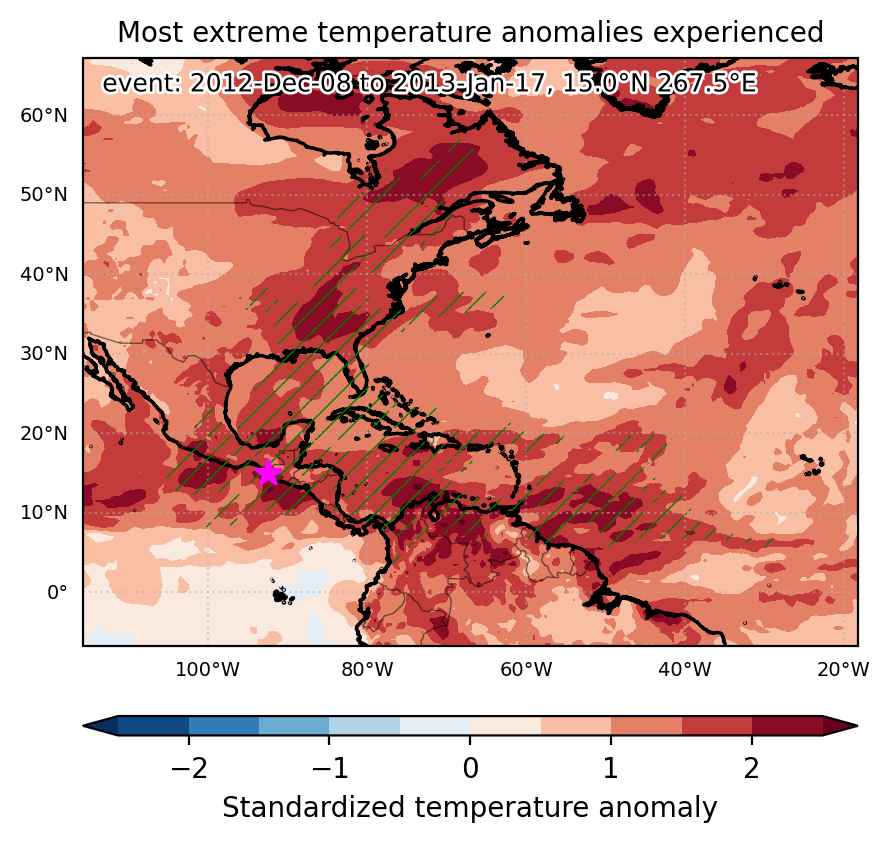
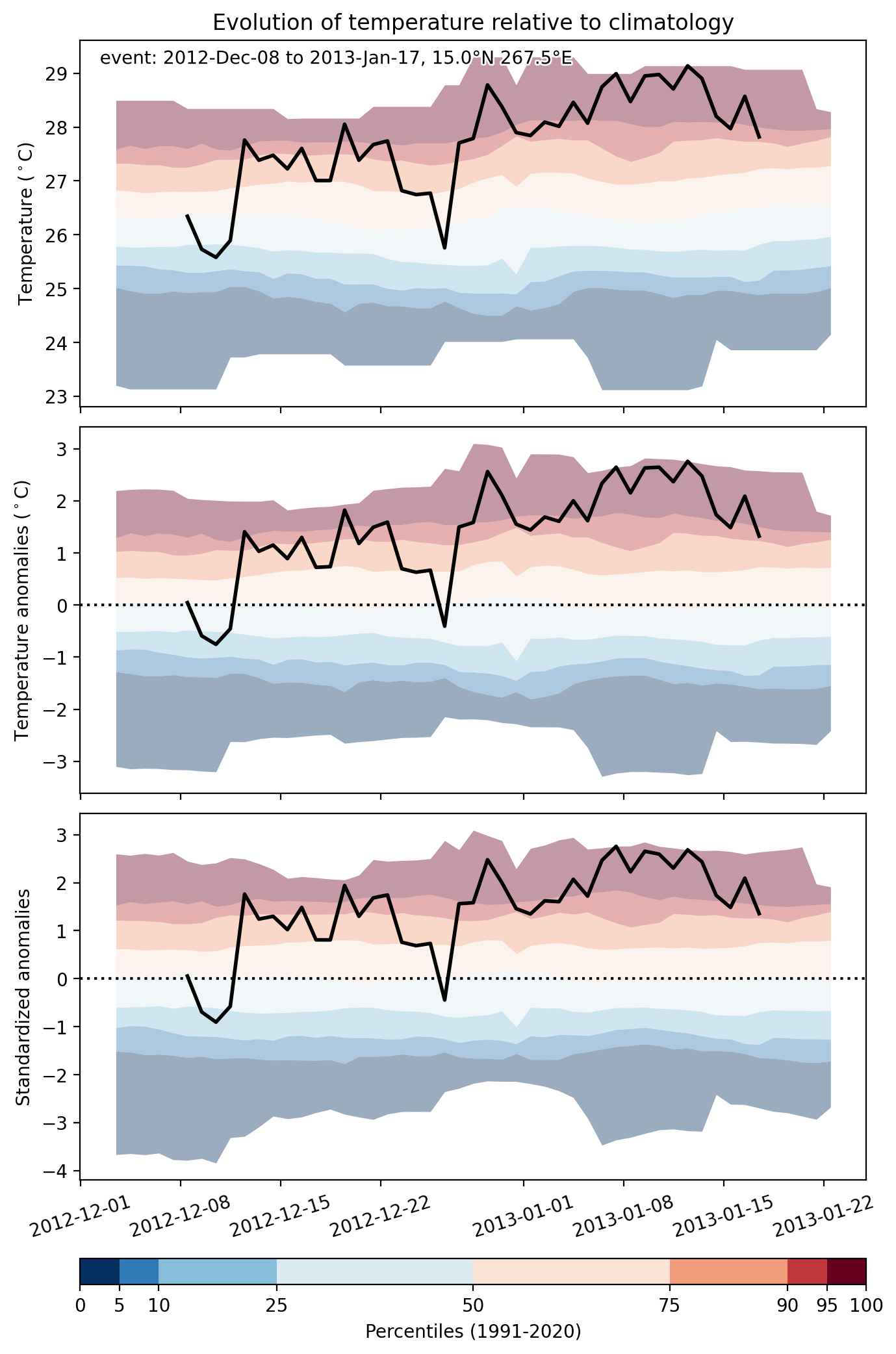
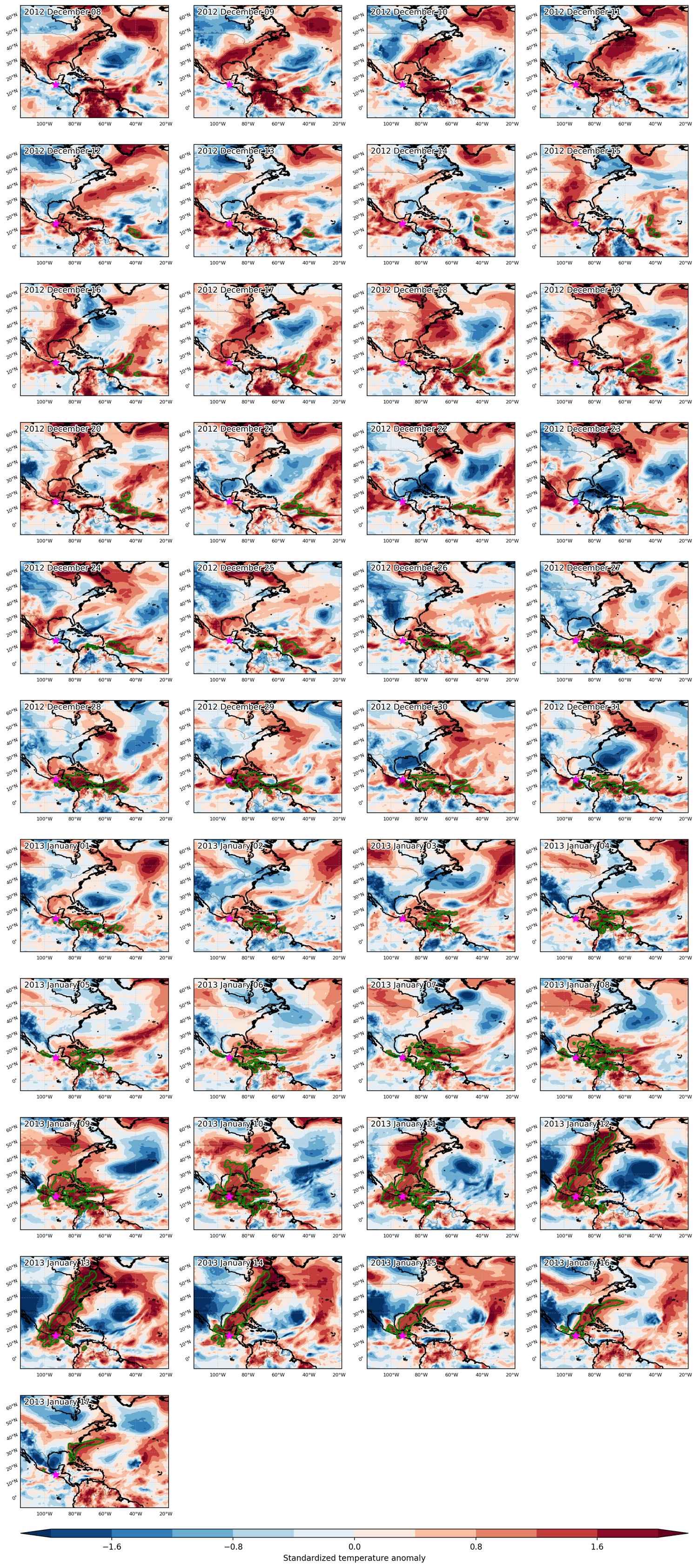
Heat wave occuring from December 08 2012 to January 17 2013 at 15.0°N 267.5°E

Download data: JSON

Event type: Heat wave

Countries affected (identified with ArcGIS Online; provided only for geographical reference):

  • Aruba
  • Bahamas
  • Belize
  • Canada
  • Colombia
  • Costa Rica
  • Cuba
  • Dominican Republic
  • El Salvador
  • Guatemala
  • Guyana
  • Honduras
  • Jamaica
  • Mexico
  • Nicaragua
  • Panama
  • Puerto Rico
  • United States
  • Venezuela

Duration: 41 days

Time span: December 08 2012 to January 17 2013

Statistics over entire affected area:

  • Mean temperature anomaly: 3.5 °C
  • Mean temperature: 23.3 °C
  • Maximum temperature anomaly: 21.7 °C
  • Maximum temperature: 32.0 °C

Event center: 15.0°N 267.5°E

Area affected: 10753067 km$^2$


Fig. 1: Map of most extreme temperature anomalies (standardized) experienced during the event. The purple star indicates the center of the extreme event. Green hatching illustrates all areas under the effect of extremes at some time during the event.


Fig. 2: Evolution of temperature at the center of the event. The climatological percentile distribution is illustrated with color shadings.


Fig. 3: Maps illustrating the evolution of standardized temperature anomalies during the event.

Event ID: Heat_wave_2012-Dec-08_to_2013-Jan-17_267.5_15.0

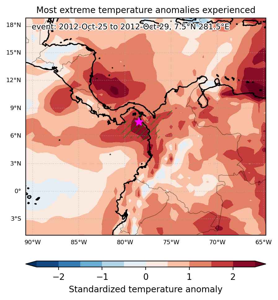
Heat wave occuring from October 25 2012 to October 29 2012 at 7.5°N 281.5°E

Download data: JSON

Event type: Heat wave

Countries affected (identified with ArcGIS Online; provided only for geographical reference):

  • Colombia
  • Panama

Duration: 5 days

Time span: October 25 2012 to October 29 2012

Statistics over entire affected area:

  • Mean temperature anomaly: 1.1 °C
  • Mean temperature: 26.7 °C
  • Maximum temperature anomaly: 1.8 °C
  • Maximum temperature: 28.4 °C

Event center: 7.5°N 281.5°E

Area affected: 98183 km$^2$


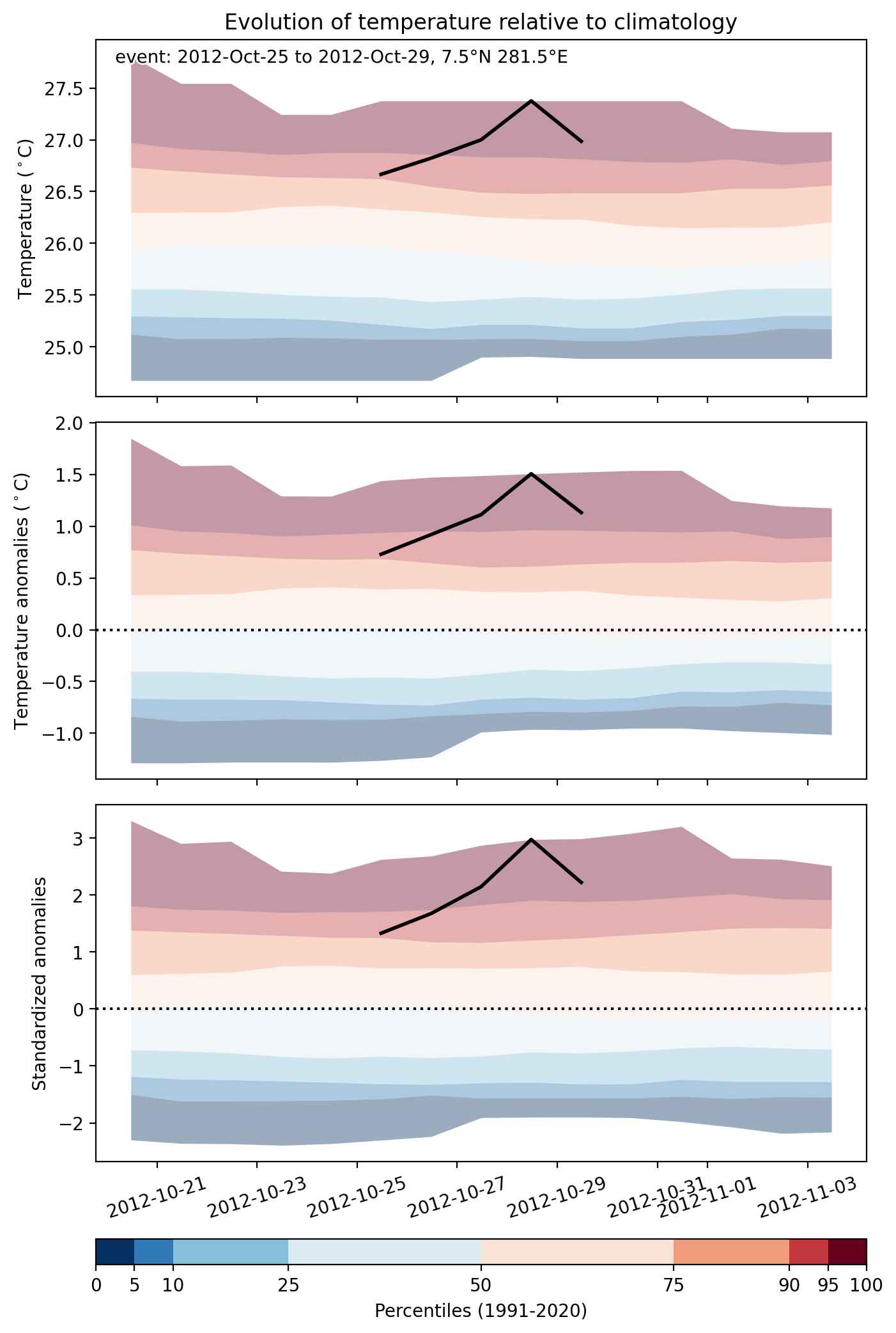
Fig. 1: Map of most extreme temperature anomalies (standardized) experienced during the event. The purple star indicates the center of the extreme event. Green hatching illustrates all areas under the effect of extremes at some time during the event.


Fig. 2: Evolution of temperature at the center of the event. The climatological percentile distribution is illustrated with color shadings.


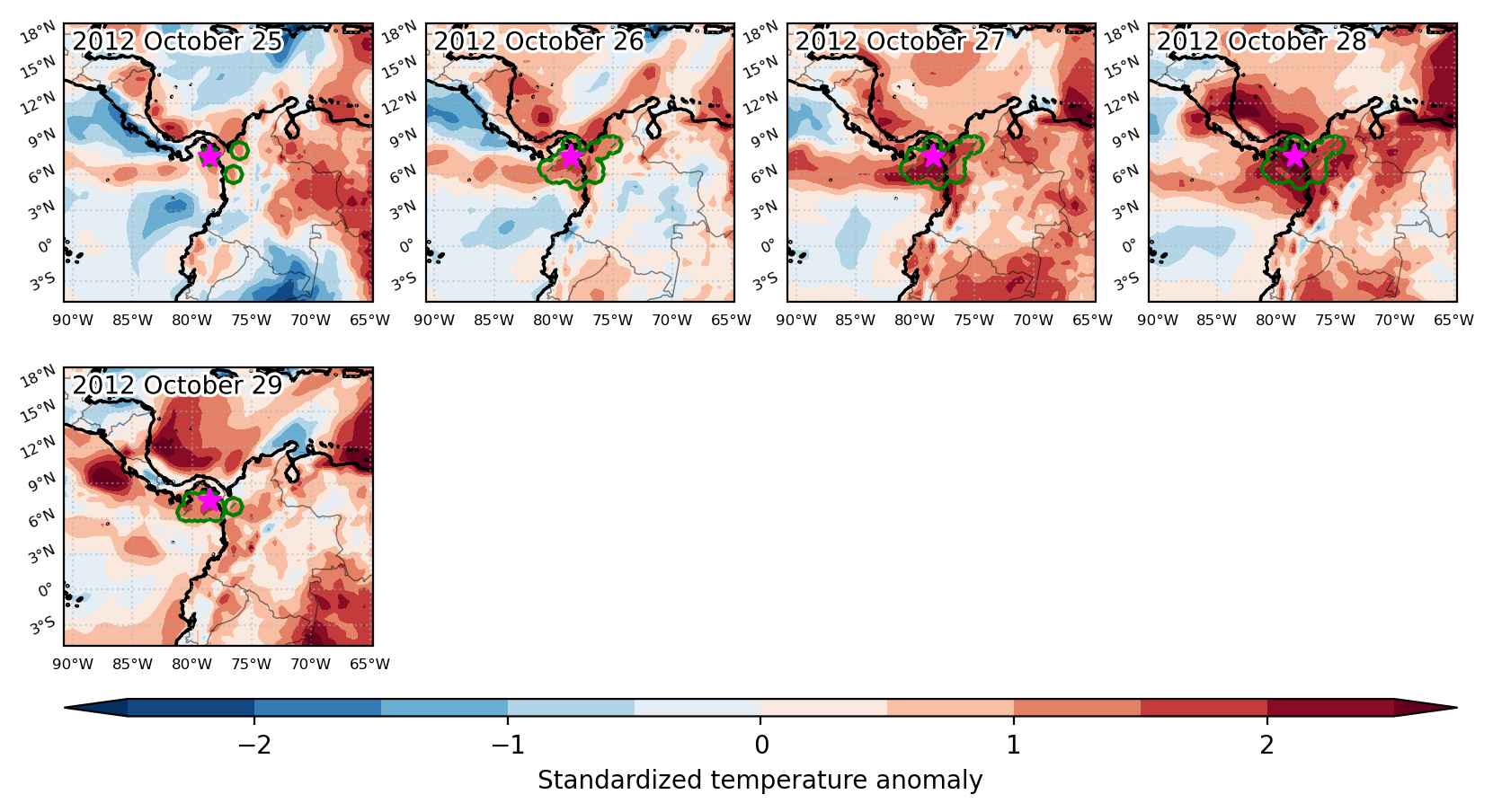
Fig. 3: Maps illustrating the evolution of standardized temperature anomalies during the event.

Event ID: Heat_wave_2012-Oct-25_to_2012-Oct-29_281.5_7.5