Heat wave occuring from July 11 2012 to October 14 2012 at 3.5°N 53.5°E

Download data: JSON

Event type: Heat wave

Countries affected (identified with ArcGIS Online; provided only for geographical reference):

  • Djibouti
  • Ethiopia
  • India
  • Iran
  • Kenya
  • Malawi
  • Mozambique
  • Oman
  • Pakistan
  • Qatar
  • Saudi Arabia
  • Somalia
  • Sri Lanka
  • Tanzania
  • United Arab Emirates
  • Yemen
  • Zambia

Duration: 96 days

Time span: July 11 2012 to October 14 2012

Statistics over entire affected area:

  • Mean temperature anomaly: 1.3 °C
  • Mean temperature: 26.7 °C
  • Maximum temperature anomaly: 5.9 °C
  • Maximum temperature: 39.5 °C

Event center: 3.5°N 53.5°E

Area affected: 21841600 km$^2$
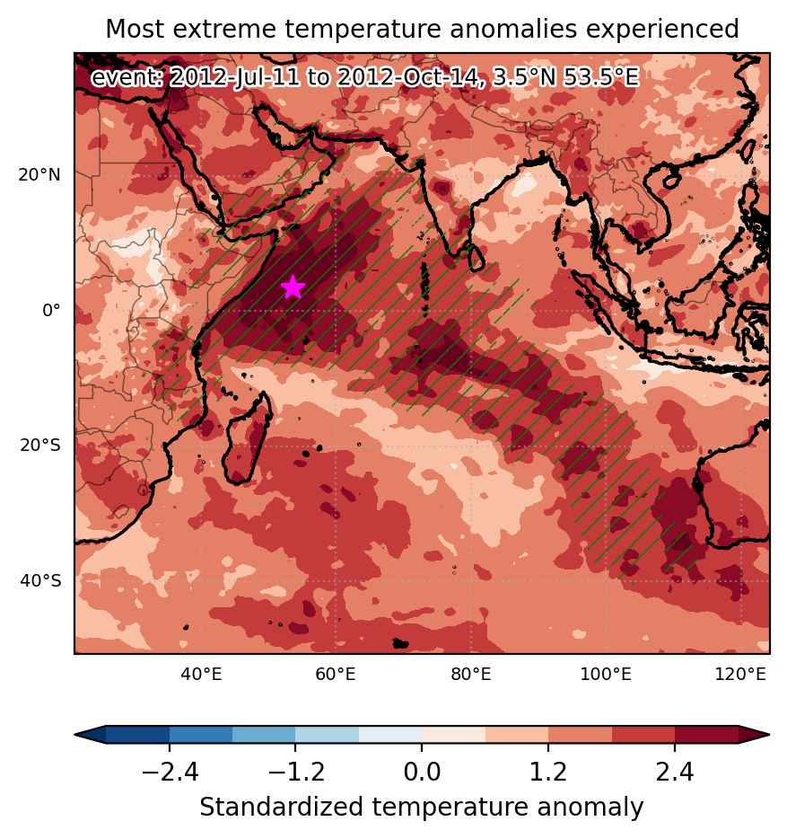

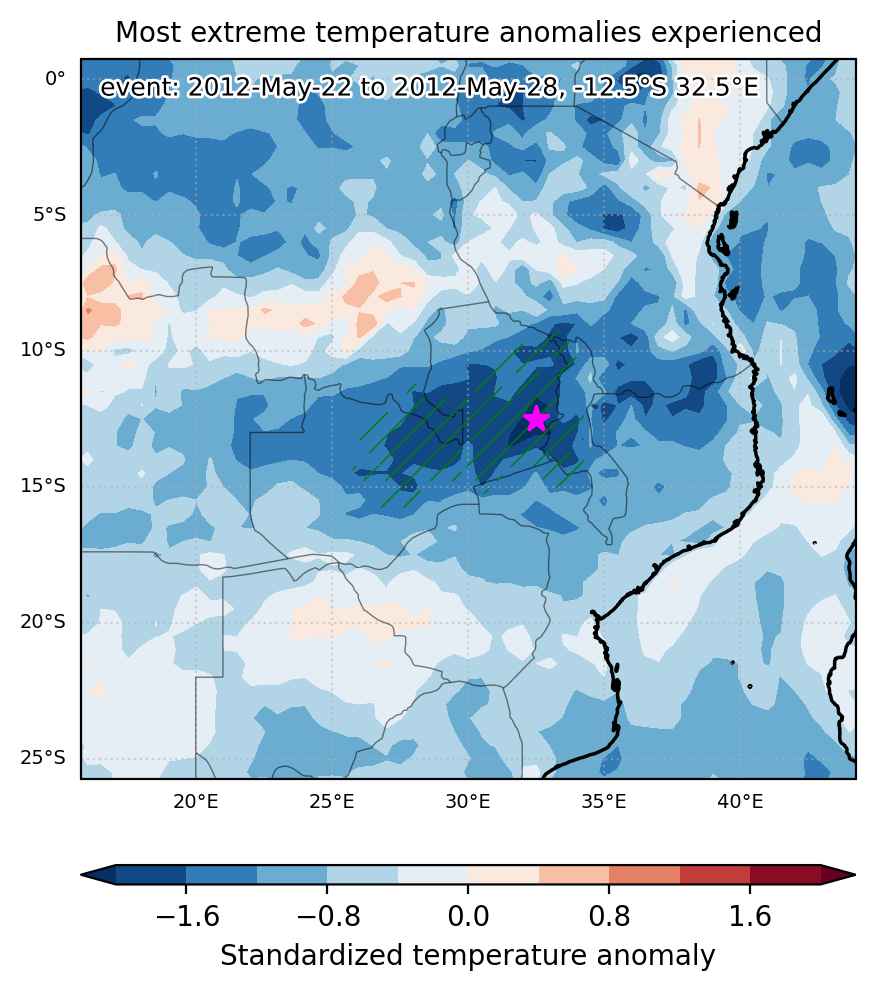
Fig. 1: Map of most extreme temperature anomalies (standardized) experienced during the event. The purple star indicates the center of the extreme event. Green hatching illustrates all areas under the effect of extremes at some time during the event.
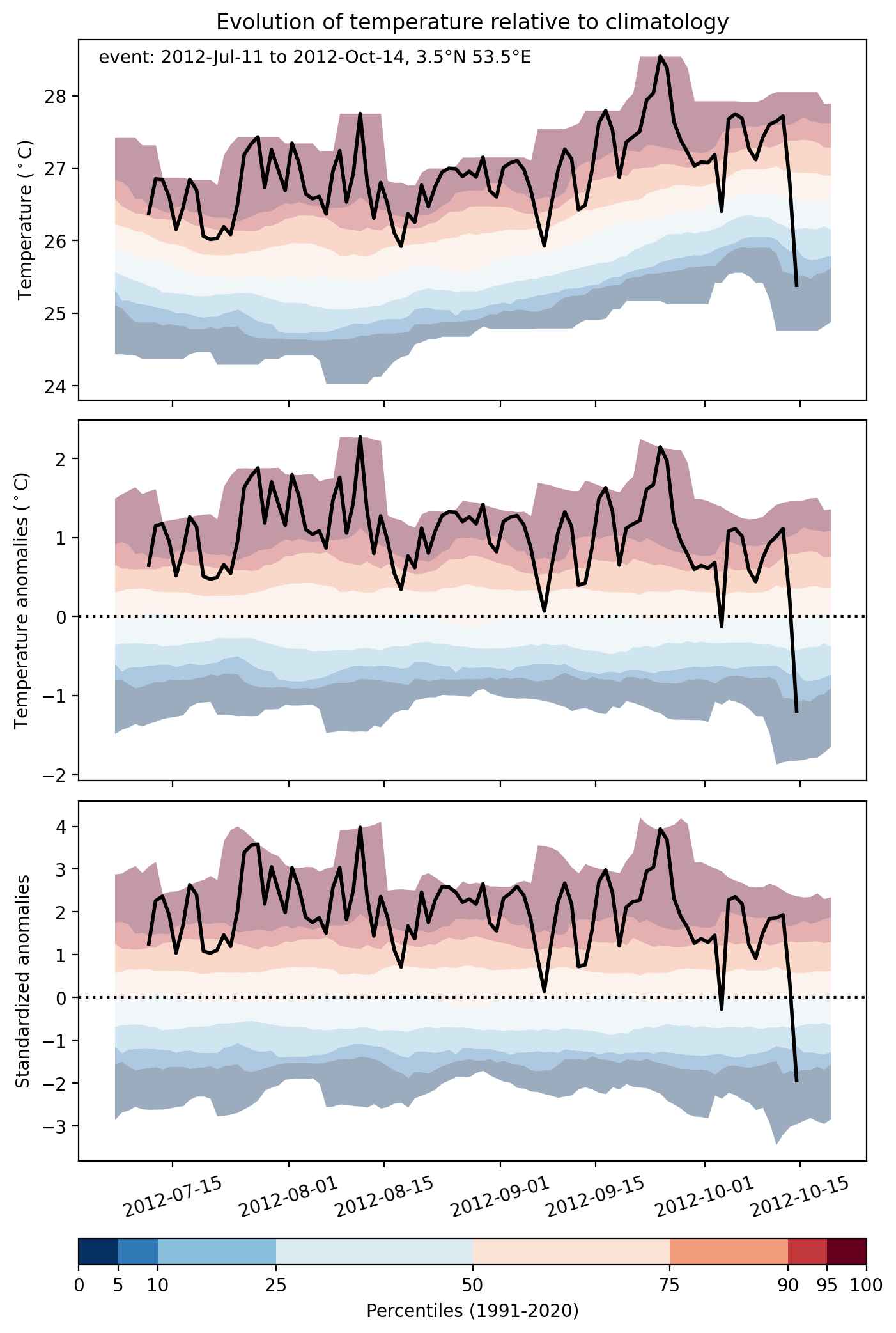


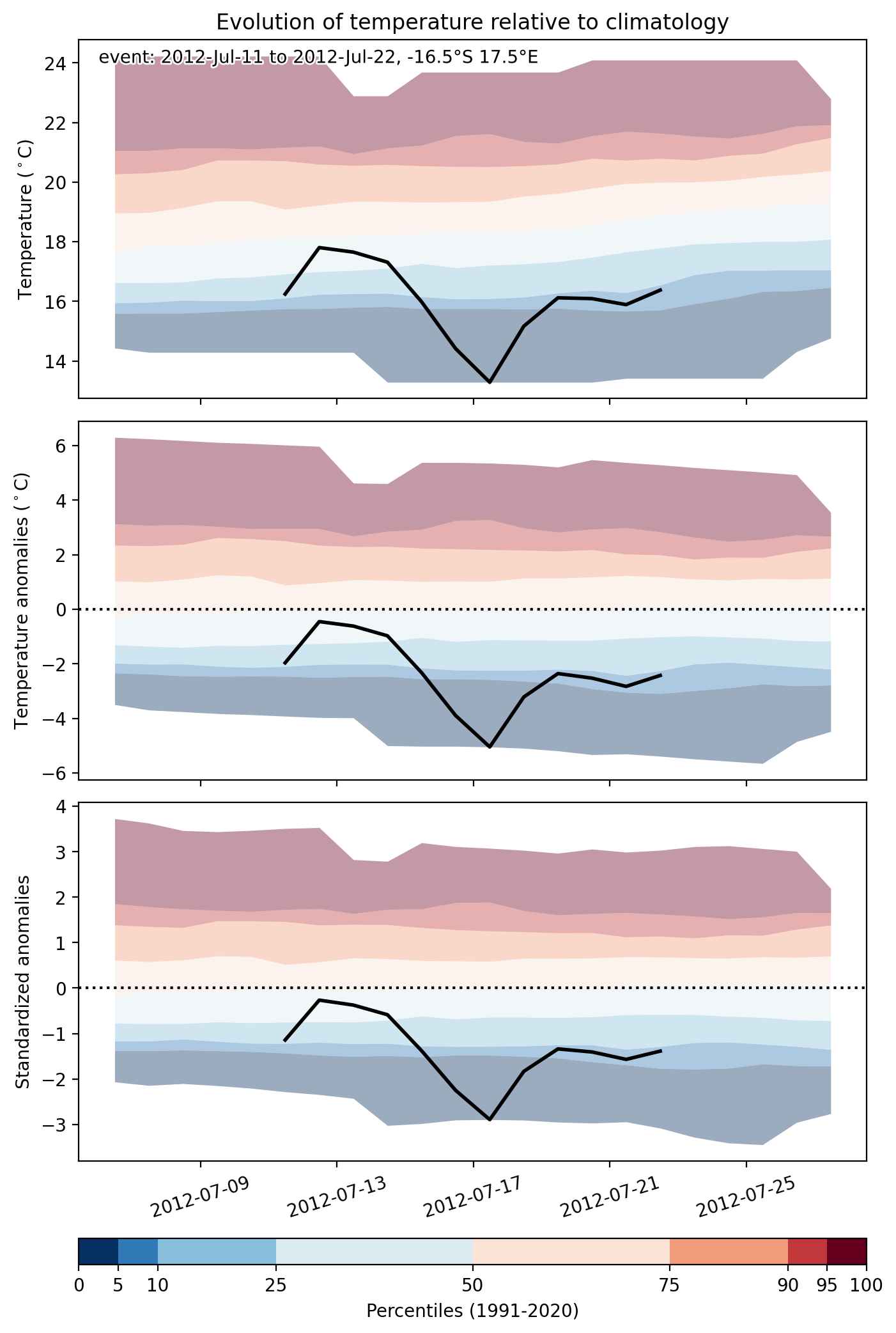
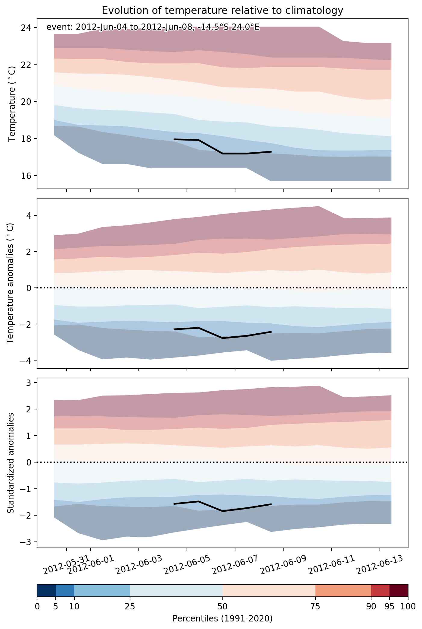
Fig. 2: Evolution of temperature at the center of the event. The climatological percentile distribution is illustrated with color shadings.
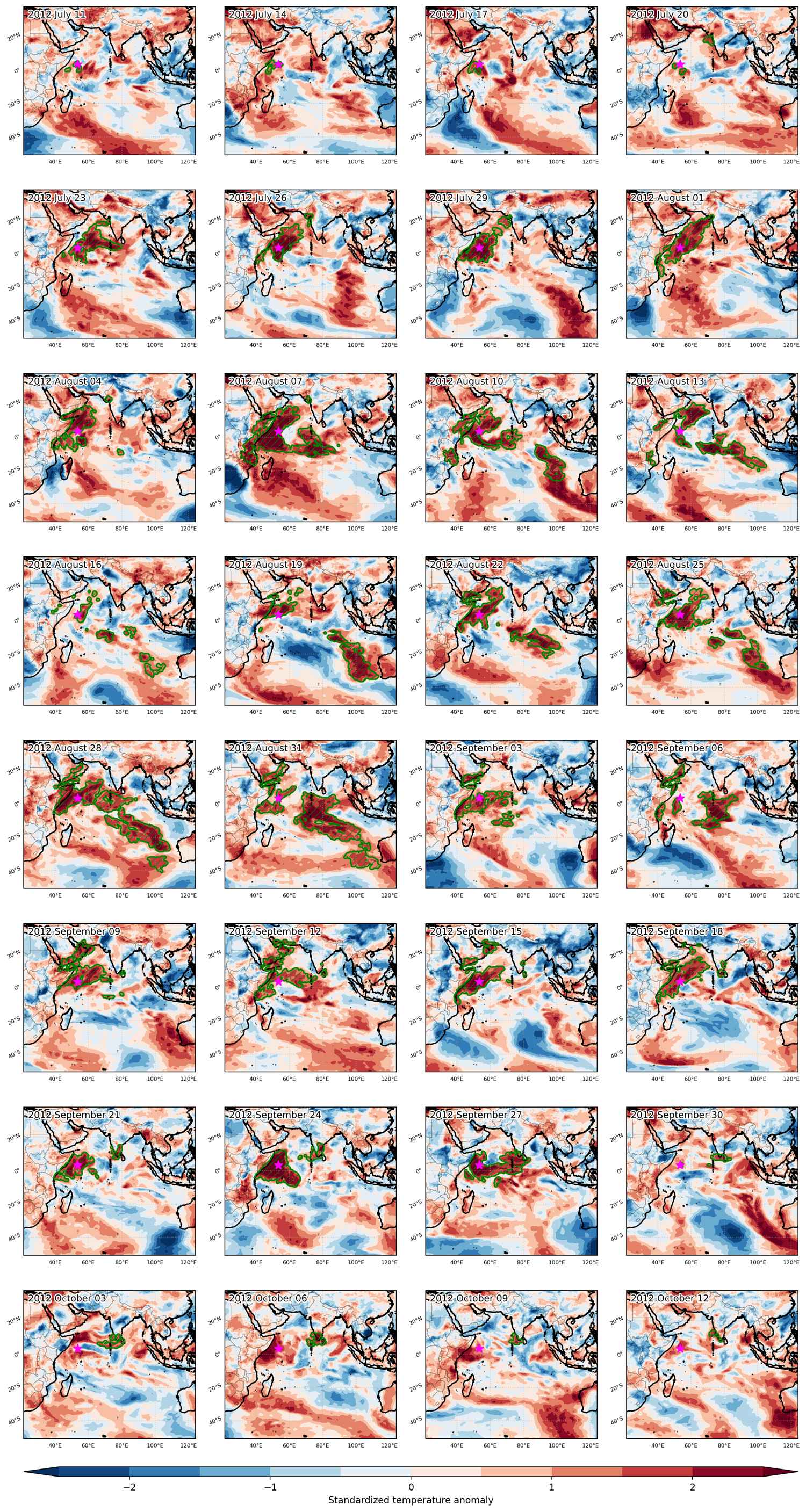


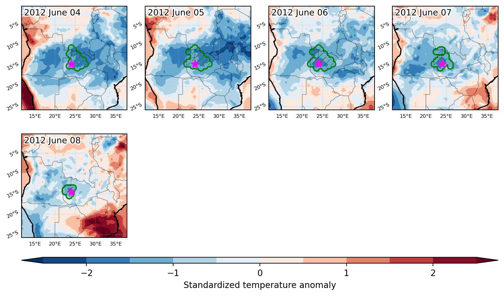
Fig. 3: Maps illustrating the evolution of standardized temperature anomalies during the event.

Event ID: Heat_wave_2012-Jul-11_to_2012-Oct-14_53.5_3.5
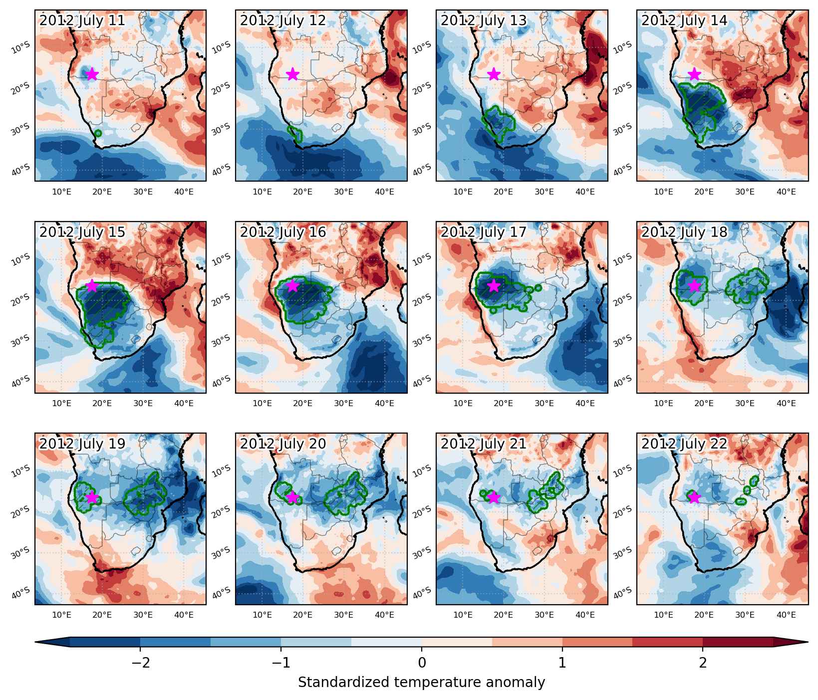
Cold spell occuring from July 11 2012 to July 22 2012 at -16.5°S 17.5°E

Download data: JSON

Event type: Cold spell

Countries affected (identified with ArcGIS Online; provided only for geographical reference):

  • Angola
  • Botswana
  • Malawi
  • Mozambique
  • Namibia
  • South Africa
  • Zambia
  • Zimbabwe

Duration: 12 days

Time span: July 11 2012 to July 22 2012

Statistics over entire affected area:

  • Mean temperature anomaly: -4.3 °C
  • Mean temperature: 11.7 °C
  • Minimum temperature anomaly: -10.2 °C
  • Minimum temperature: 2.1 °C

Event center: -16.5°S 17.5°E

Area affected: 1708173 km$^2$


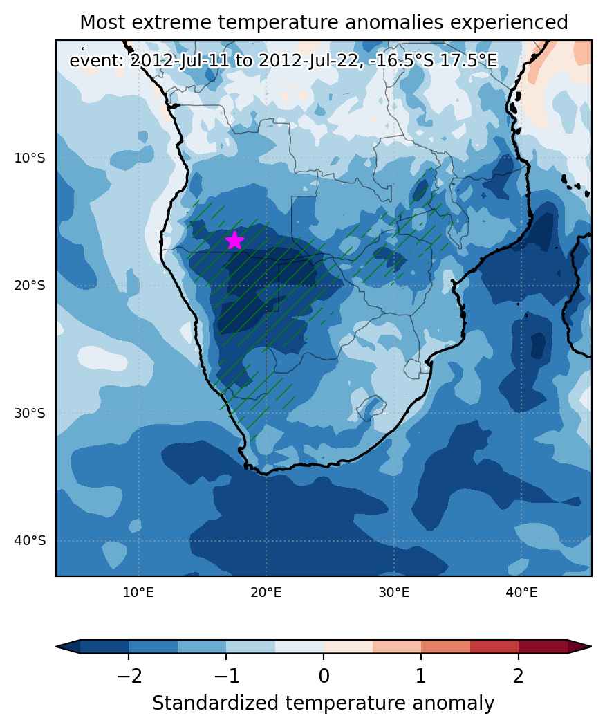
Fig. 1: Map of most extreme temperature anomalies (standardized) experienced during the event. The purple star indicates the center of the extreme event. Green hatching illustrates all areas under the effect of extremes at some time during the event.


Fig. 2: Evolution of temperature at the center of the event. The climatological percentile distribution is illustrated with color shadings.


Fig. 3: Maps illustrating the evolution of standardized temperature anomalies during the event.

Event ID: Cold_spell_2012-Jul-11_to_2012-Jul-22_17.5_-16.5

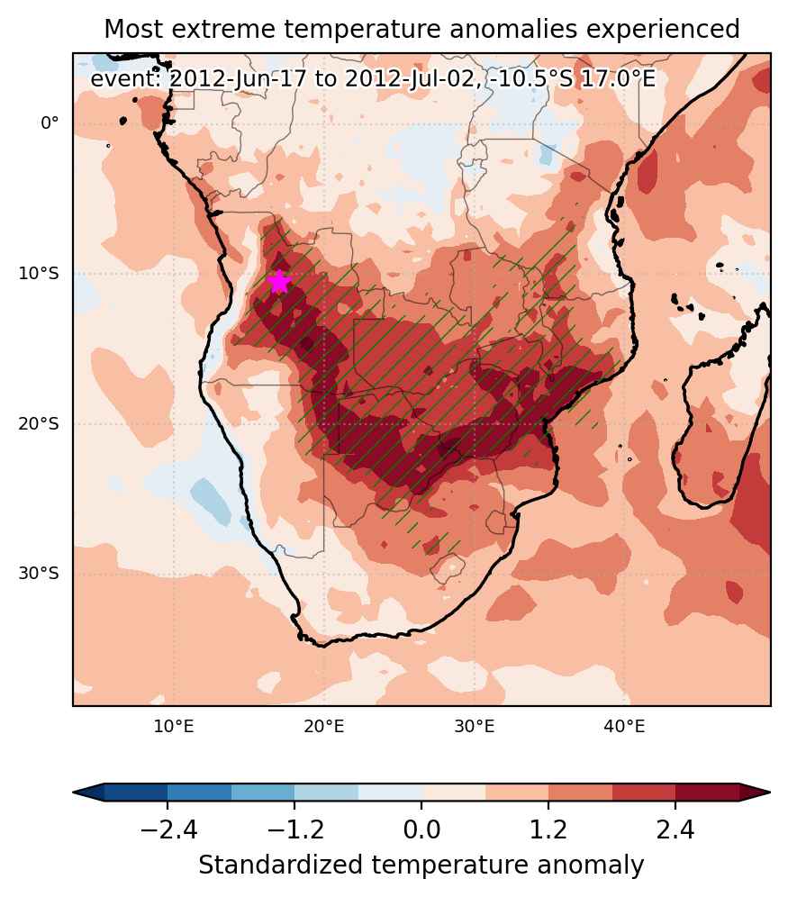
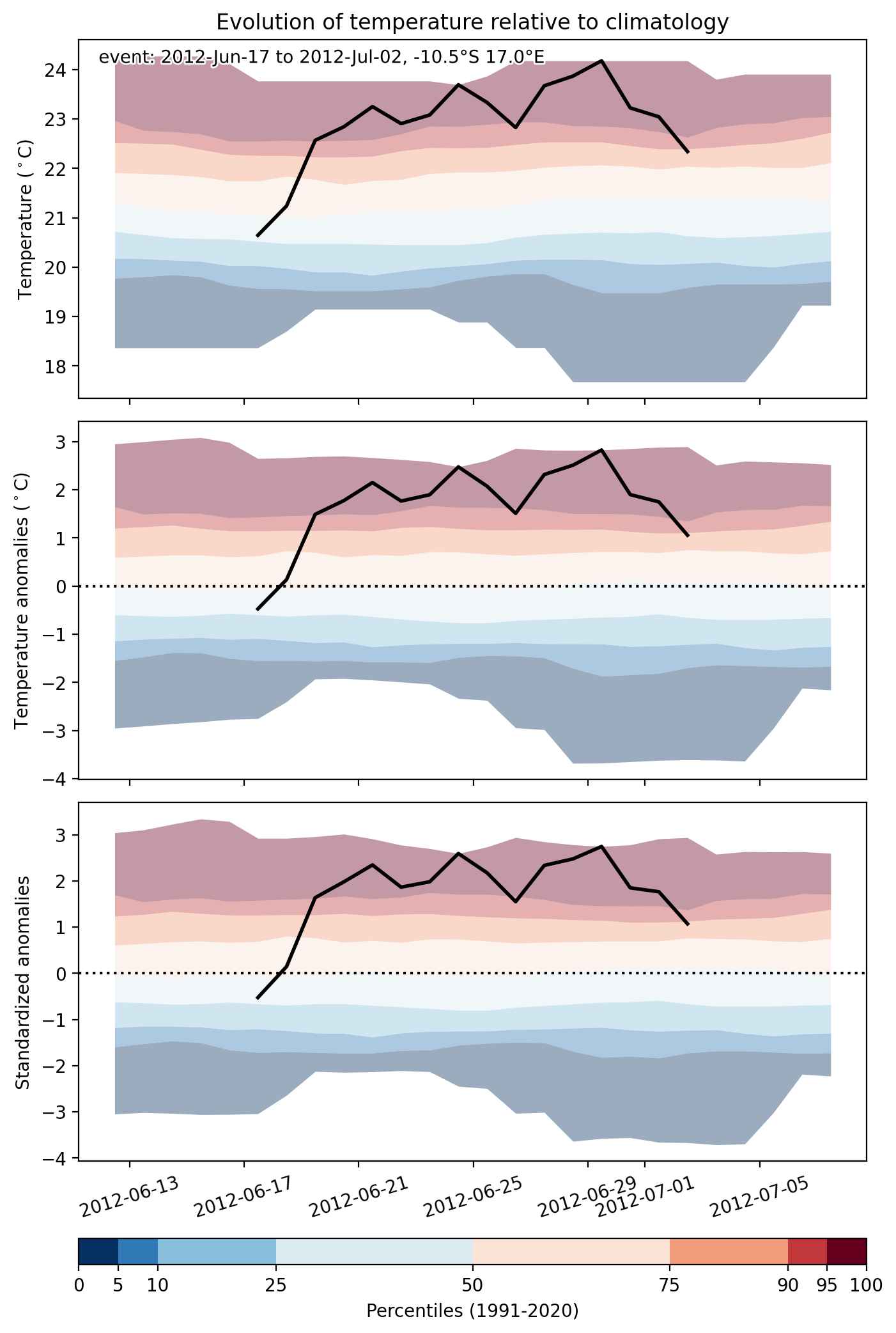
Heat wave occuring from June 17 2012 to July 02 2012 at -10.5°S 17.0°E

Download data: JSON

Event type: Heat wave

Countries affected (identified with ArcGIS Online; provided only for geographical reference):

  • Angola
  • Botswana
  • Congo DRC
  • Malawi
  • Mozambique
  • Namibia
  • South Africa
  • Tanzania
  • Zambia
  • Zimbabwe

Duration: 16 days

Time span: June 17 2012 to July 02 2012

Statistics over entire affected area:

  • Mean temperature anomaly: 2.9 °C
  • Mean temperature: 20.6 °C
  • Maximum temperature anomaly: 7.5 °C
  • Maximum temperature: 27.5 °C

Event center: -10.5°S 17.0°E

Area affected: 3115542 km$^2$


Fig. 1: Map of most extreme temperature anomalies (standardized) experienced during the event. The purple star indicates the center of the extreme event. Green hatching illustrates all areas under the effect of extremes at some time during the event.


Fig. 2: Evolution of temperature at the center of the event. The climatological percentile distribution is illustrated with color shadings.


Fig. 3: Maps illustrating the evolution of standardized temperature anomalies during the event.

Event ID: Heat_wave_2012-Jun-17_to_2012-Jul-02_17.0_-10.5

Heat wave occuring from June 29 2012 to July 09 2012 at -26.0°S 26.5°E

Download data: JSON

Event type: Heat wave

Countries affected (identified with ArcGIS Online; provided only for geographical reference):

  • Botswana
  • Namibia
  • South Africa
  • Zambia
  • Zimbabwe

Duration: 11 days

Time span: June 29 2012 to July 09 2012

Statistics over entire affected area:

  • Mean temperature anomaly: 3.5 °C
  • Mean temperature: 16.8 °C
  • Maximum temperature anomaly: 6.9 °C
  • Maximum temperature: 21.6 °C

Event center: -26.0°S 26.5°E

Area affected: 861674 km$^2$


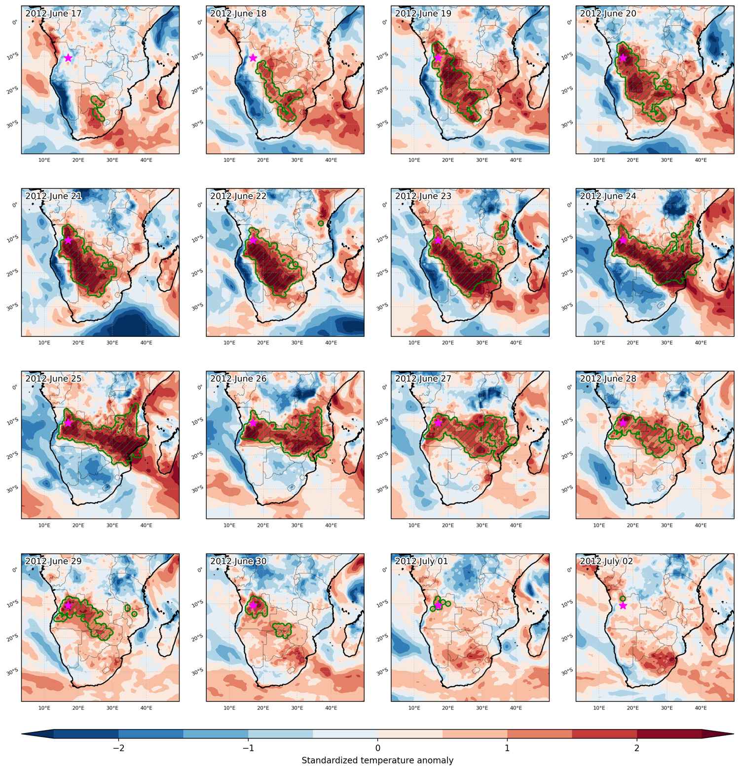
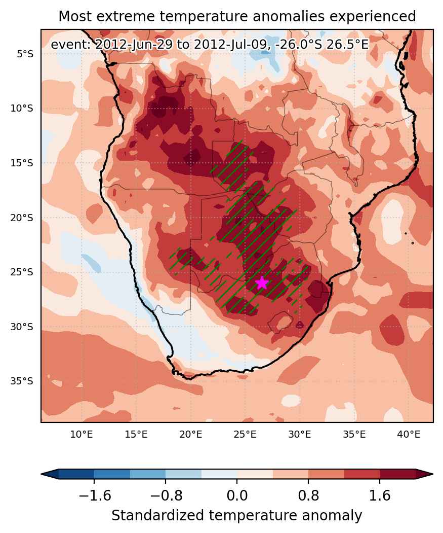
Fig. 1: Map of most extreme temperature anomalies (standardized) experienced during the event. The purple star indicates the center of the extreme event. Green hatching illustrates all areas under the effect of extremes at some time during the event.


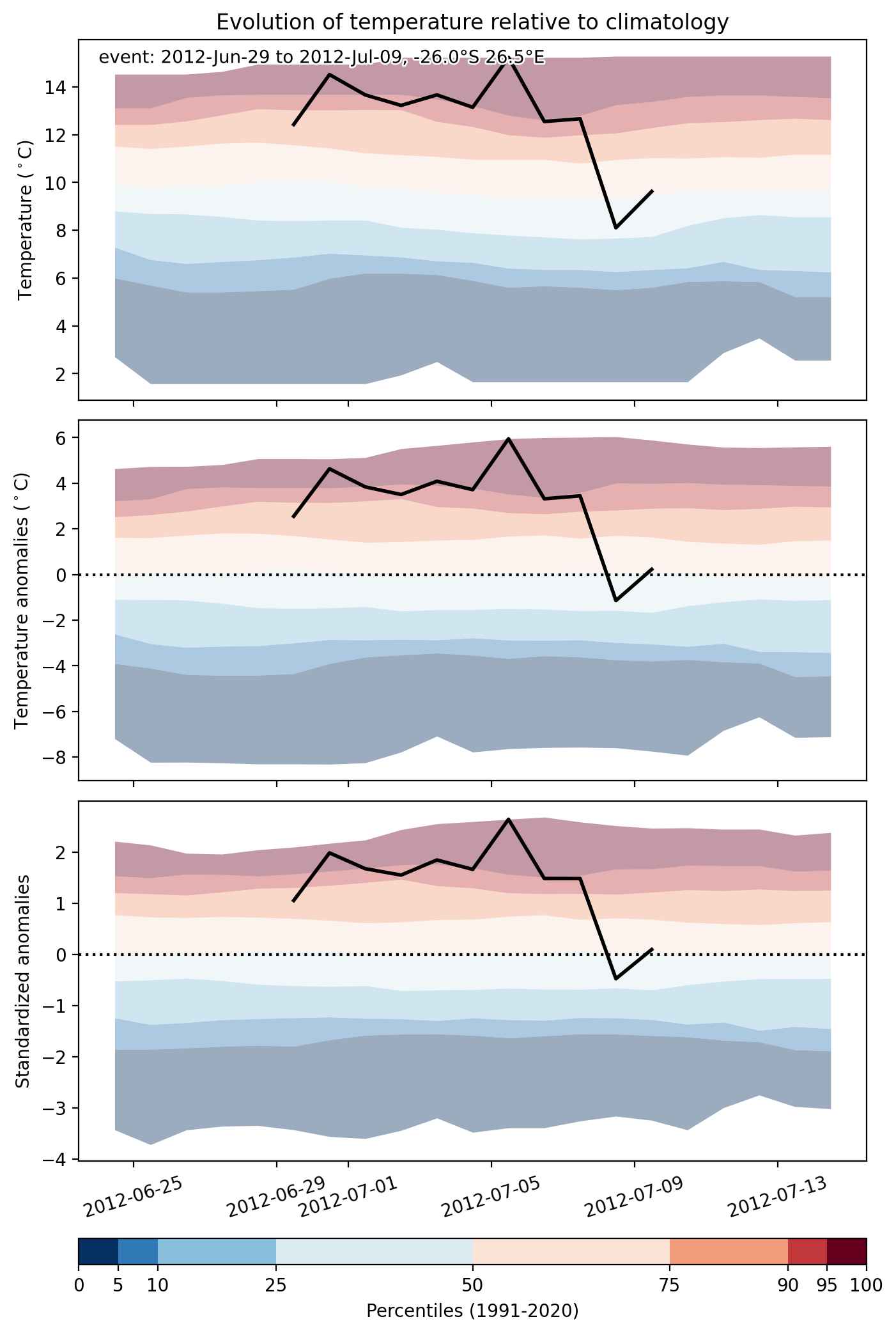
Fig. 2: Evolution of temperature at the center of the event. The climatological percentile distribution is illustrated with color shadings.


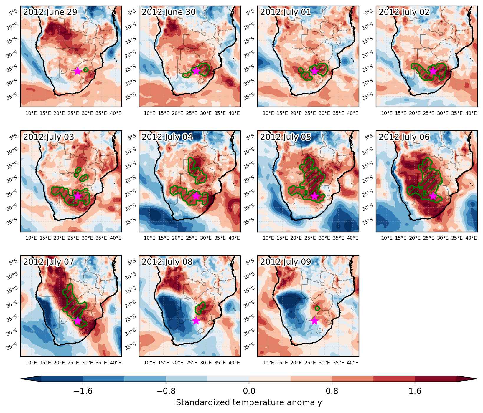
Fig. 3: Maps illustrating the evolution of standardized temperature anomalies during the event.

Event ID: Heat_wave_2012-Jun-29_to_2012-Jul-09_26.5_-26.0

Cold spell occuring from June 04 2012 to June 16 2012 at -30.0°S 28.0°E

Download data: JSON

Event type: Cold spell

Countries affected (identified with ArcGIS Online; provided only for geographical reference):

  • Angola
  • Botswana
  • Congo DRC
  • Lesotho
  • Malawi
  • Mozambique
  • Namibia
  • South Africa
  • Zambia
  • Zimbabwe

Duration: 13 days

Time span: June 04 2012 to June 16 2012

Statistics over entire affected area:

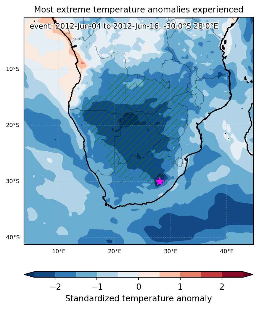
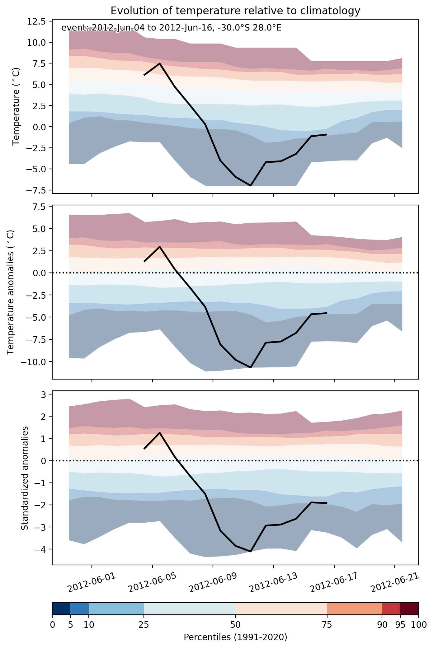
  • Mean temperature anomaly: -3.8 °C
  • Mean temperature: 12.0 °C
  • Minimum temperature anomaly: -11.1 °C
  • Minimum temperature: -7.4 °C

Event center: -30.0°S 28.0°E

Area affected: 2875523 km$^2$


Fig. 1: Map of most extreme temperature anomalies (standardized) experienced during the event. The purple star indicates the center of the extreme event. Green hatching illustrates all areas under the effect of extremes at some time during the event.


Fig. 2: Evolution of temperature at the center of the event. The climatological percentile distribution is illustrated with color shadings.


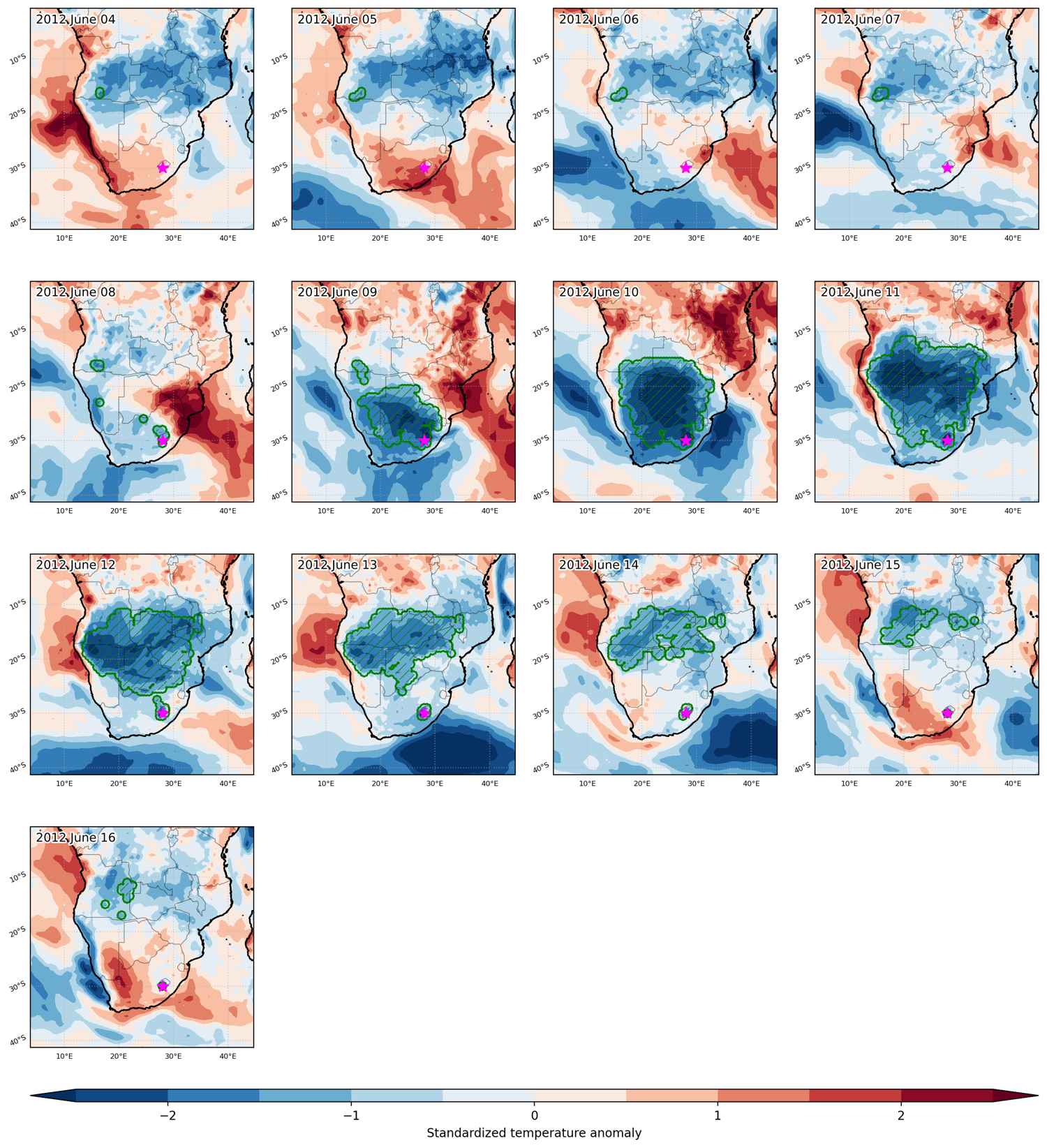
Fig. 3: Maps illustrating the evolution of standardized temperature anomalies during the event.

Event ID: Cold_spell_2012-Jun-04_to_2012-Jun-16_28.0_-30.0

Cold spell occuring from June 04 2012 to June 08 2012 at -14.5°S 24.0°E

Download data: JSON

Event type: Cold spell

Countries affected (identified with ArcGIS Online; provided only for geographical reference):

  • Angola
  • Congo DRC
  • Zambia

Duration: 5 days

Time span: June 04 2012 to June 08 2012

Statistics over entire affected area:

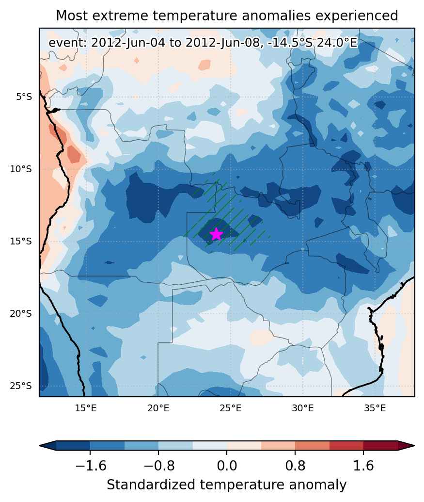
  • Mean temperature anomaly: -2.3 °C
  • Mean temperature: 17.1 °C
  • Minimum temperature anomaly: -3.1 °C
  • Minimum temperature: 15.3 °C

Event center: -14.5°S 24.0°E

Area affected: 186342 km$^2$


Fig. 1: Map of most extreme temperature anomalies (standardized) experienced during the event. The purple star indicates the center of the extreme event. Green hatching illustrates all areas under the effect of extremes at some time during the event.


Fig. 2: Evolution of temperature at the center of the event. The climatological percentile distribution is illustrated with color shadings.


Fig. 3: Maps illustrating the evolution of standardized temperature anomalies during the event.

Event ID: Cold_spell_2012-Jun-04_to_2012-Jun-08_24.0_-14.5

Cold spell occuring from May 22 2012 to May 28 2012 at -12.5°S 32.5°E

Download data: JSON

Event type: Cold spell

Countries affected (identified with ArcGIS Online; provided only for geographical reference):

  • Congo DRC
  • Malawi
  • Mozambique
  • Tanzania
  • Zambia

Duration: 7 days

Time span: May 22 2012 to May 28 2012

Statistics over entire affected area:

  • Mean temperature anomaly: -2.4 °C
  • Mean temperature: 17.5 °C
  • Minimum temperature anomaly: -3.7 °C
  • Minimum temperature: 13.8 °C

Event center: -12.5°S 32.5°E

Area affected: 349473 km$^2$


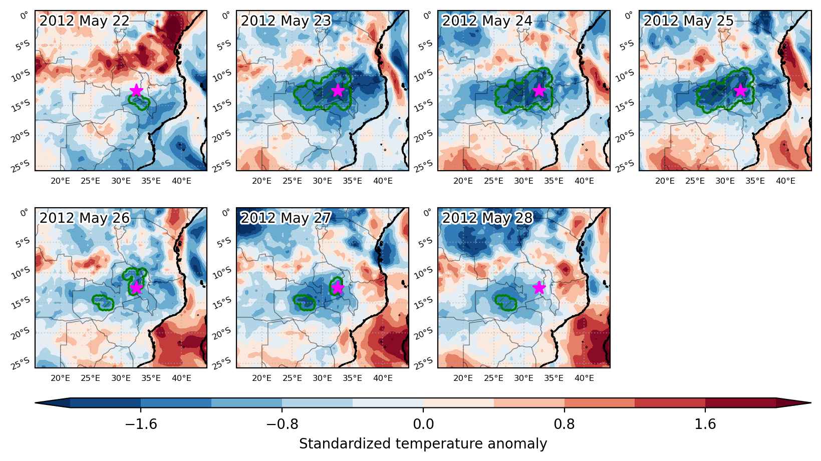
Fig. 1: Map of most extreme temperature anomalies (standardized) experienced during the event. The purple star indicates the center of the extreme event. Green hatching illustrates all areas under the effect of extremes at some time during the event.


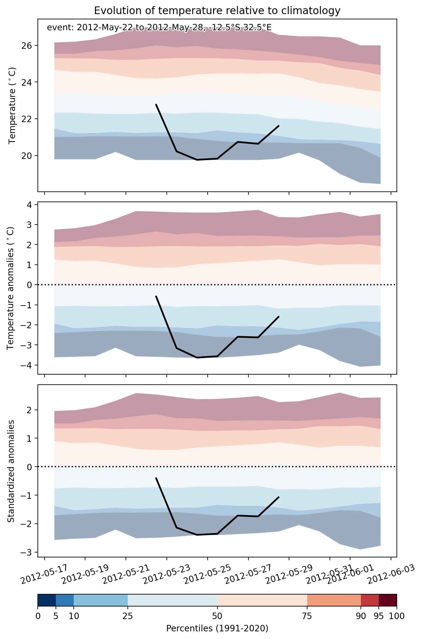
Fig. 2: Evolution of temperature at the center of the event. The climatological percentile distribution is illustrated with color shadings.


Fig. 3: Maps illustrating the evolution of standardized temperature anomalies during the event.

Event ID: Cold_spell_2012-May-22_to_2012-May-28_32.5_-12.5

Cold spell occuring from April 12 2012 to April 29 2012 at -13.0°S 32.0°E

Download data: JSON

Event type: Cold spell

Countries affected (identified with ArcGIS Online; provided only for geographical reference):

  • Angola
  • Botswana
  • Congo DRC
  • Malawi
  • Mozambique
  • Namibia
  • South Africa
  • Tanzania
  • Zambia
  • Zimbabwe

Duration: 18 days

Time span: April 12 2012 to April 29 2012

Statistics over entire affected area:

  • Mean temperature anomaly: -2.3 °C
  • Mean temperature: 19.8 °C
  • Minimum temperature anomaly: -4.9 °C
  • Minimum temperature: 12.4 °C

Event center: -13.0°S 32.0°E

Area affected: 2138070 km$^2$


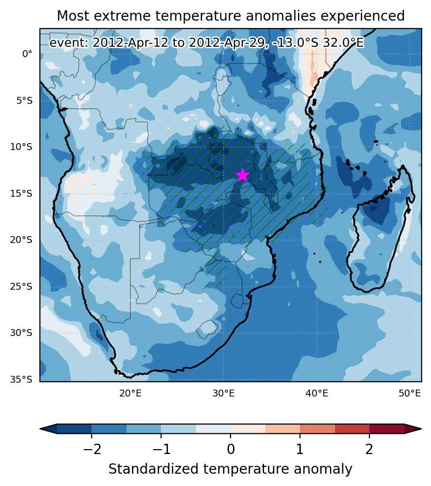
Fig. 1: Map of most extreme temperature anomalies (standardized) experienced during the event. The purple star indicates the center of the extreme event. Green hatching illustrates all areas under the effect of extremes at some time during the event.


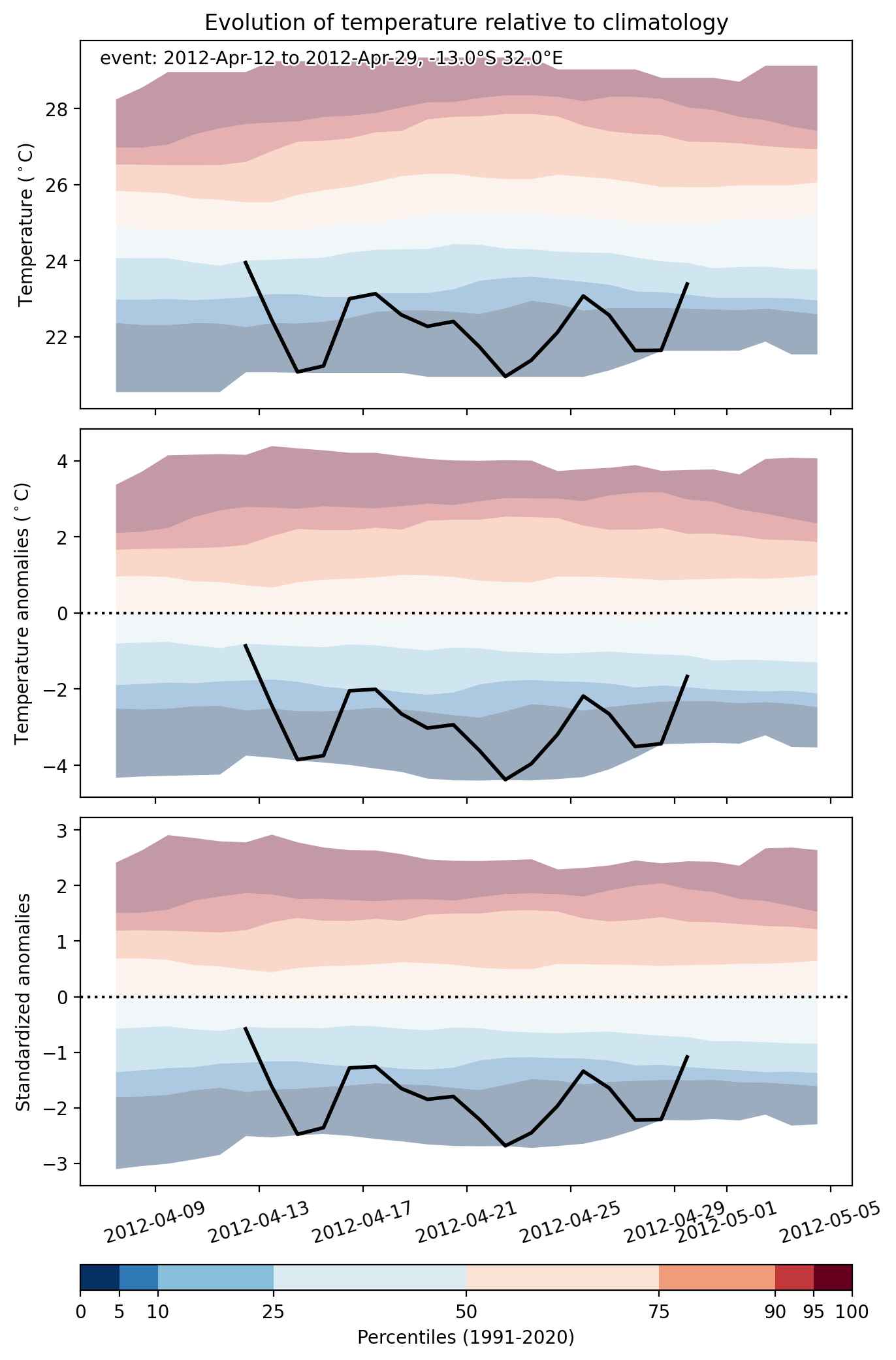
Fig. 2: Evolution of temperature at the center of the event. The climatological percentile distribution is illustrated with color shadings.


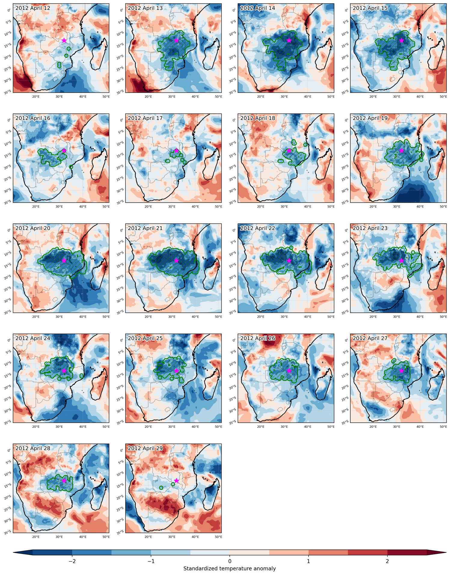
Fig. 3: Maps illustrating the evolution of standardized temperature anomalies during the event.

Event ID: Cold_spell_2012-Apr-12_to_2012-Apr-29_32.0_-13.0

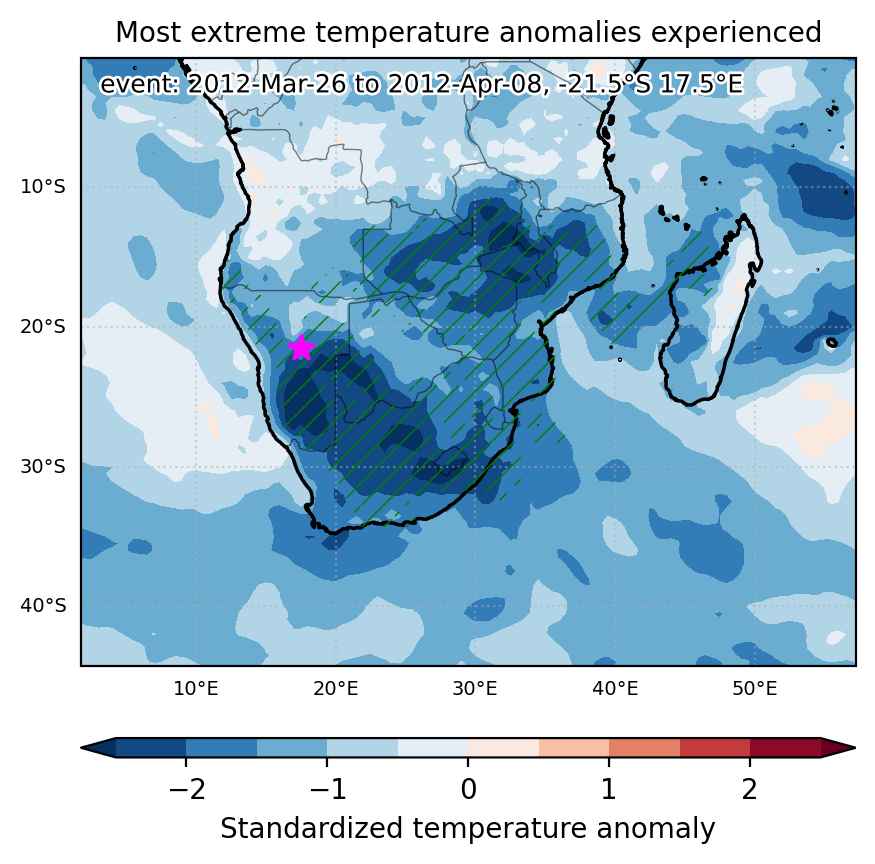
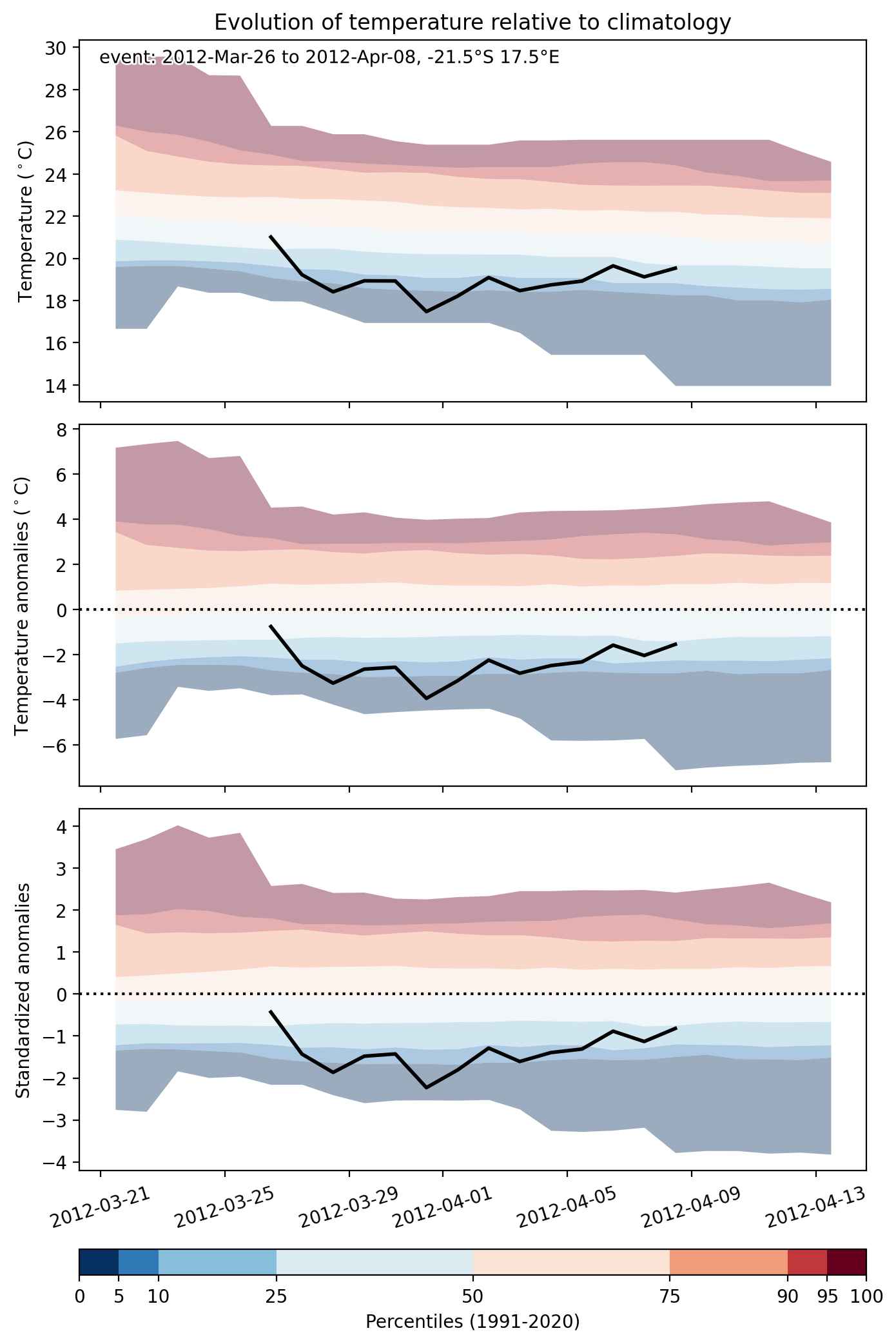
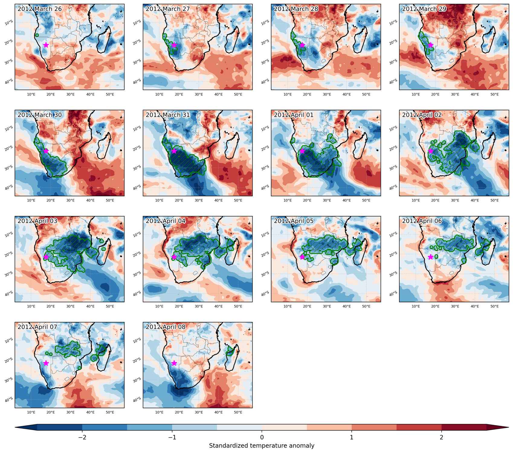
Cold spell occuring from March 26 2012 to April 08 2012 at -21.5°S 17.5°E

Download data: JSON

Event type: Cold spell

Countries affected (identified with ArcGIS Online; provided only for geographical reference):

  • Angola
  • Botswana
  • Congo DRC
  • Eswatini
  • Lesotho
  • Madagascar
  • Malawi
  • Mozambique
  • Namibia
  • South Africa
  • Zambia
  • Zimbabwe

Duration: 14 days

Time span: March 26 2012 to April 08 2012

Statistics over entire affected area:

  • Mean temperature anomaly: -3.5 °C
  • Mean temperature: 19.2 °C
  • Minimum temperature anomaly: -11.0 °C
  • Minimum temperature: 4.6 °C

Event center: -21.5°S 17.5°E

Area affected: 3781144 km$^2$


Fig. 1: Map of most extreme temperature anomalies (standardized) experienced during the event. The purple star indicates the center of the extreme event. Green hatching illustrates all areas under the effect of extremes at some time during the event.


Fig. 2: Evolution of temperature at the center of the event. The climatological percentile distribution is illustrated with color shadings.


Fig. 3: Maps illustrating the evolution of standardized temperature anomalies during the event.

Event ID: Cold_spell_2012-Mar-26_to_2012-Apr-08_17.5_-21.5

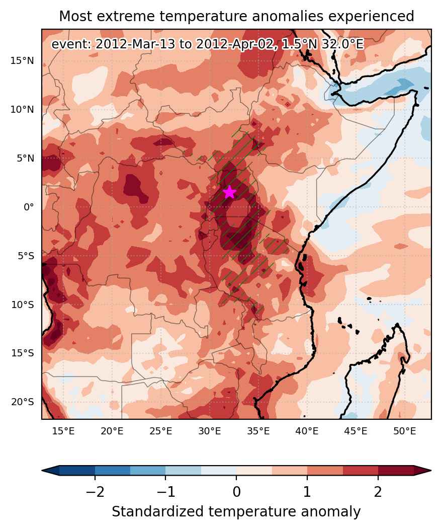
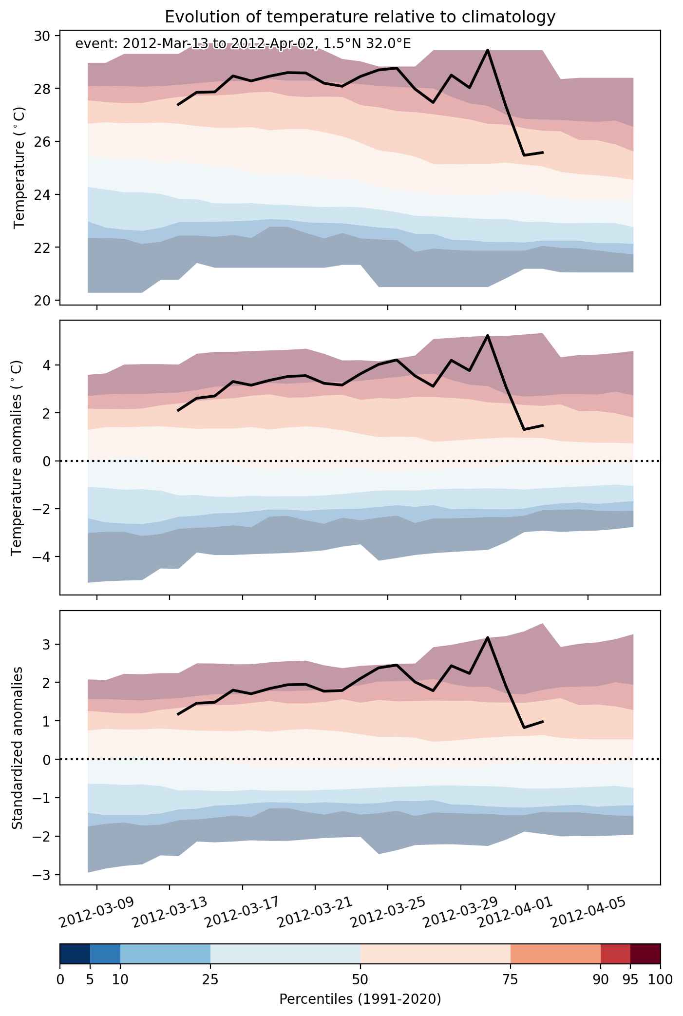
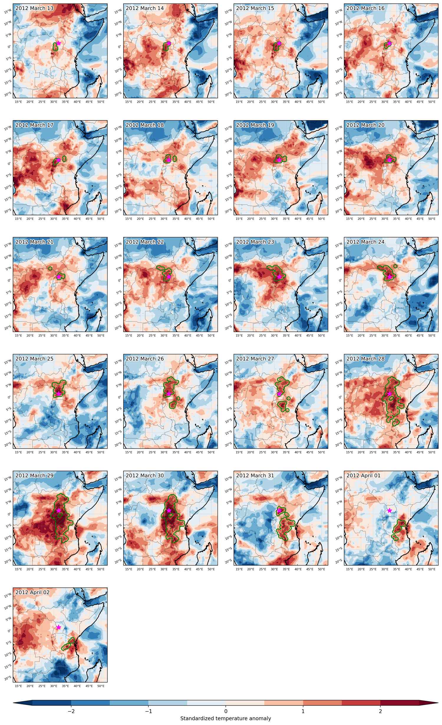
Heat wave occuring from March 13 2012 to April 02 2012 at 1.5°N 32.0°E

Download data: JSON

Event type: Heat wave

Countries affected (identified with ArcGIS Online; provided only for geographical reference):

  • Congo DRC
  • Ethiopia
  • Kenya
  • Malawi
  • South Sudan
  • Tanzania
  • Uganda
  • Zambia

Duration: 21 days

Time span: March 13 2012 to April 02 2012

Statistics over entire affected area:

  • Mean temperature anomaly: 2.8 °C
  • Mean temperature: 27.5 °C
  • Maximum temperature anomaly: 5.8 °C
  • Maximum temperature: 35.6 °C

Event center: 1.5°N 32.0°E

Area affected: 825132 km$^2$


Fig. 1: Map of most extreme temperature anomalies (standardized) experienced during the event. The purple star indicates the center of the extreme event. Green hatching illustrates all areas under the effect of extremes at some time during the event.


Fig. 2: Evolution of temperature at the center of the event. The climatological percentile distribution is illustrated with color shadings.


Fig. 3: Maps illustrating the evolution of standardized temperature anomalies during the event.

Event ID: Heat_wave_2012-Mar-13_to_2012-Apr-02_32.0_1.5