Cold spell occuring from May 29 2026 to June 01 2026 at 34.0°N 45.0°E

Download data: JSON

Event type: Cold spell

Countries affected (identified with ArcGIS Online; provided only for geographical reference):

  • Iran
  • Iraq

Duration: 4 days

Time span: May 29 2026 to June 01 2026

Statistics over entire affected area:

  • Mean temperature anomaly: -3.7 °C
  • Mean temperature: 28.9 °C
  • Minimum temperature anomaly: -5.0 °C
  • Minimum temperature: 19.0 °C

Event center: 34.0°N 45.0°E

Area affected: 84772 km$^2$
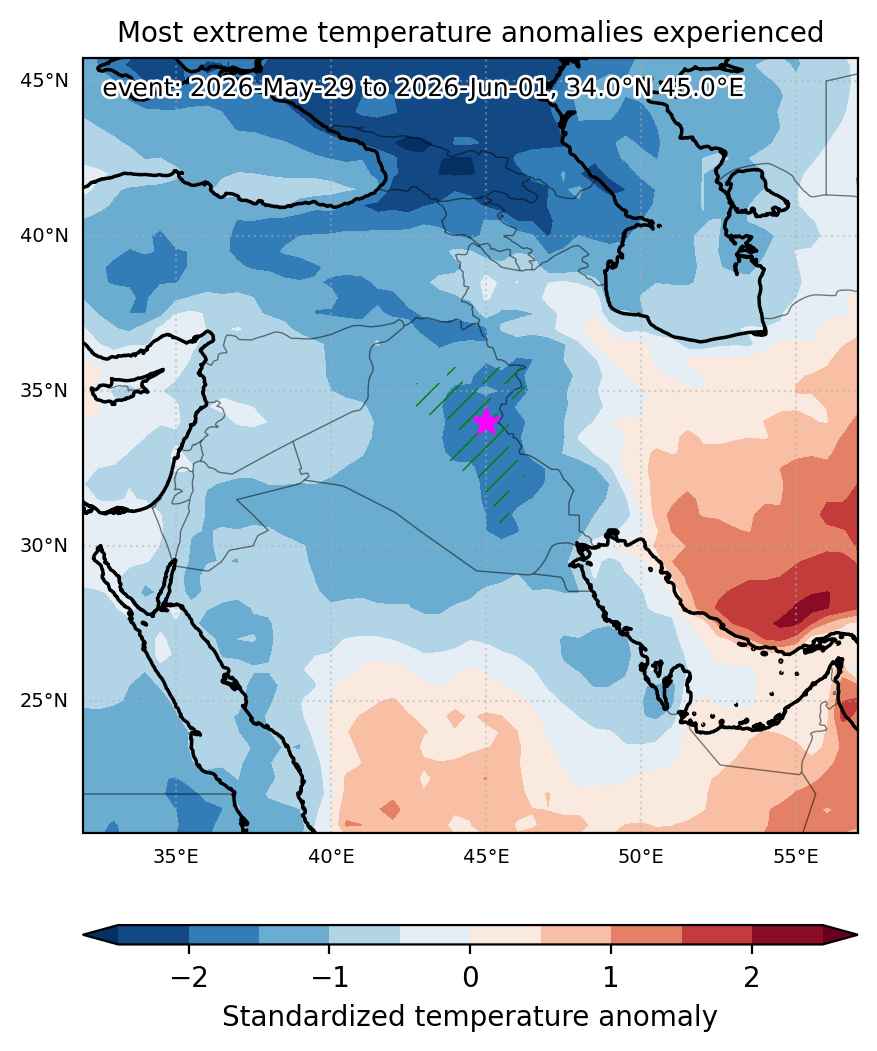

Fig. 1: Map of most extreme temperature anomalies (standardized) experienced during the event. The purple star indicates the center of the extreme event. Green hatching illustrates all areas under the effect of extremes at some time during the event.
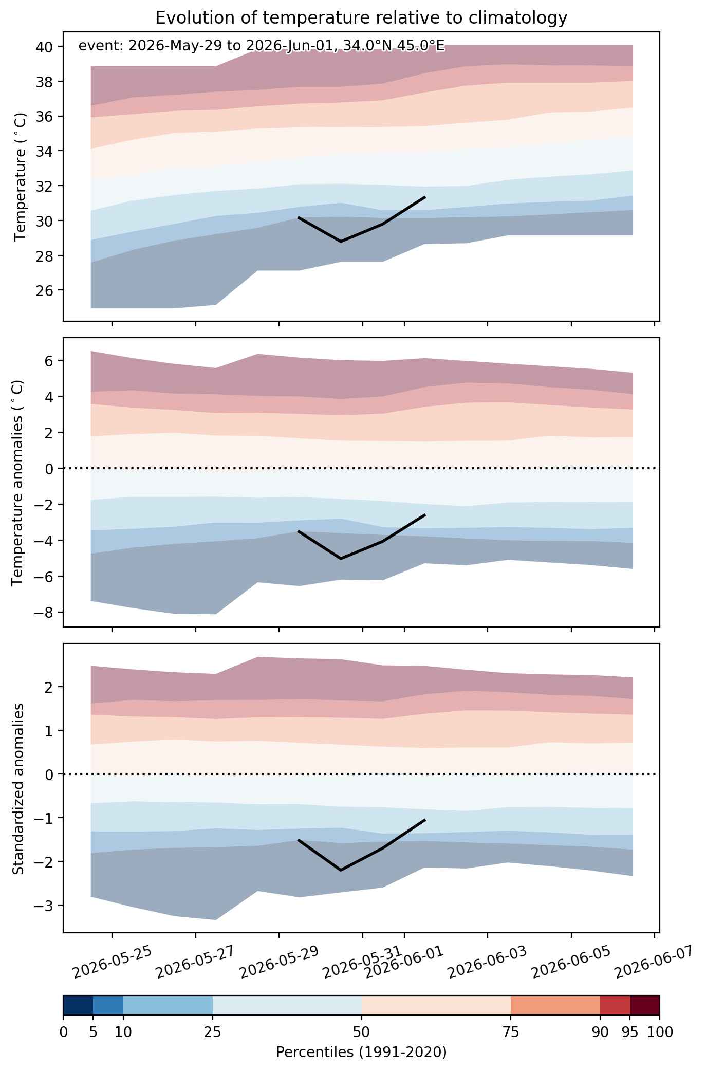


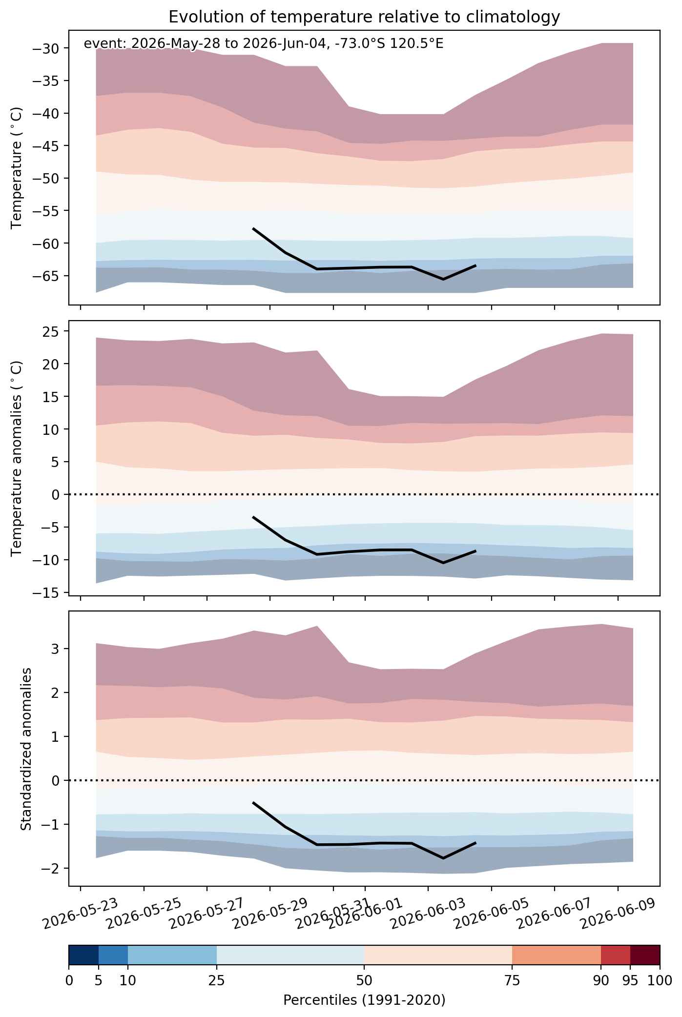
Fig. 2: Evolution of temperature at the center of the event. The climatological percentile distribution is illustrated with color shadings.
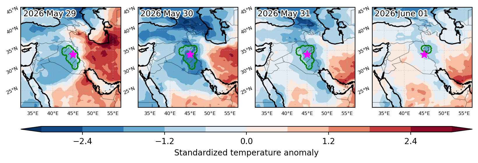


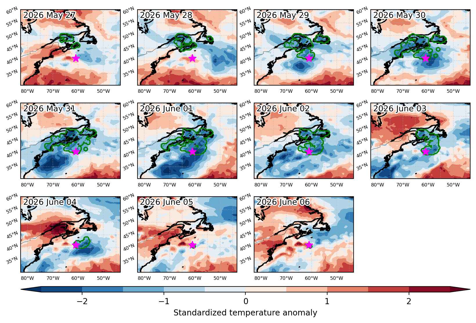
Fig. 3: Maps illustrating the evolution of standardized temperature anomalies during the event.

Event ID: Cold_spell_2026-May-29_to_2026-Jun-01_45.0_34.0
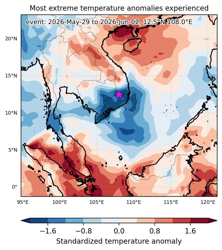
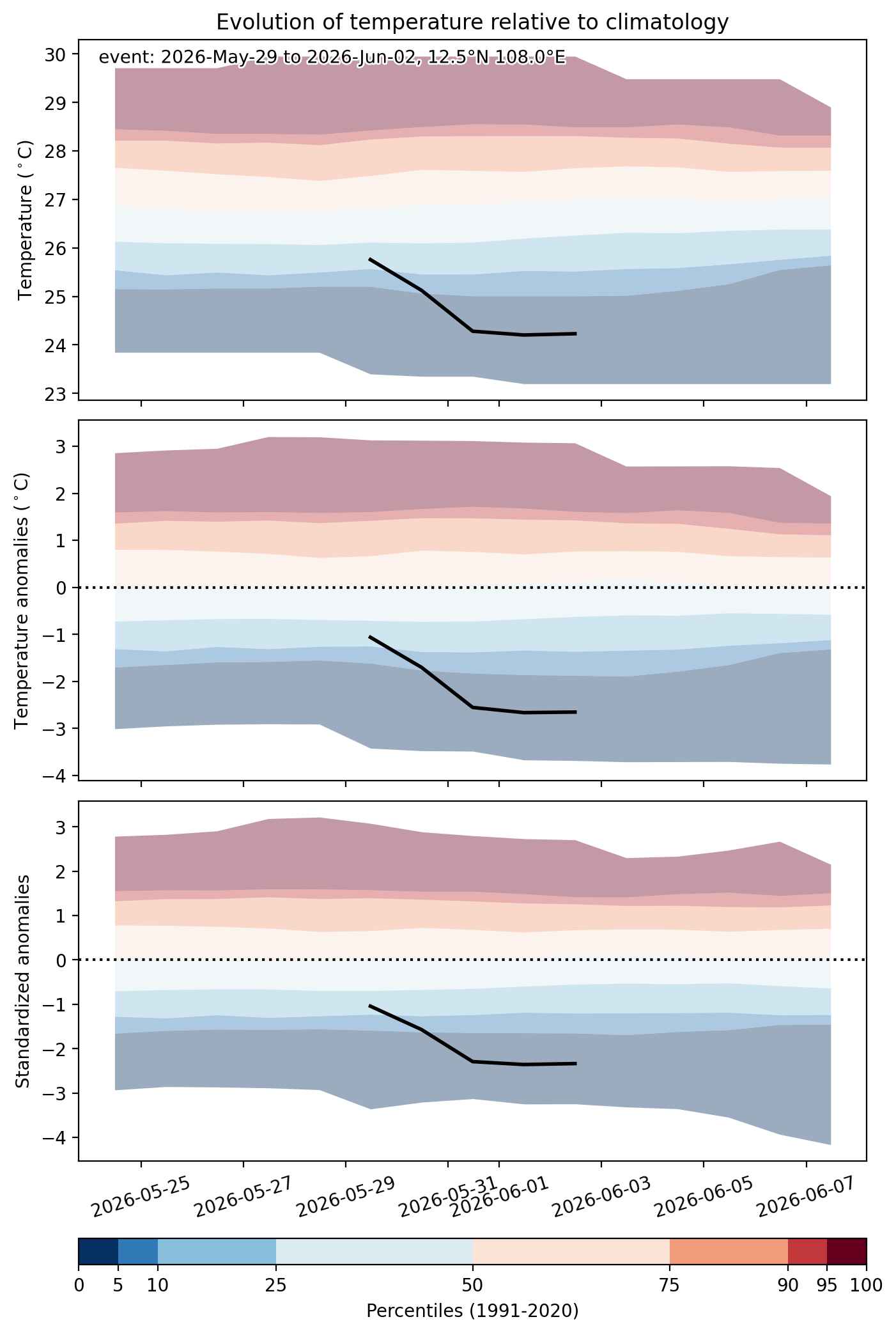
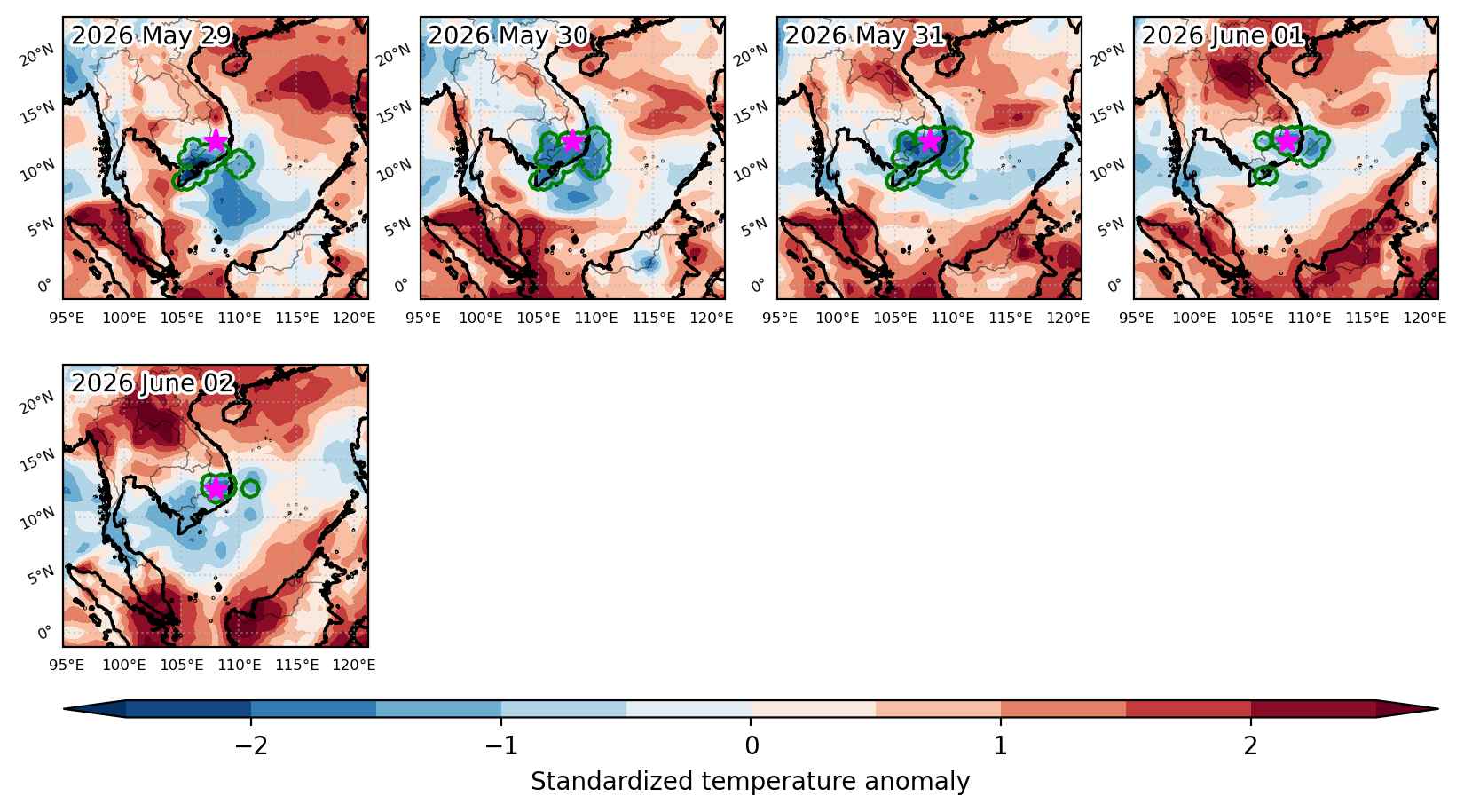
Cold spell occuring from May 29 2026 to June 02 2026 at 12.5°N 108.0°E

Download data: JSON

Event type: Cold spell

Countries affected (identified with ArcGIS Online; provided only for geographical reference):

  • Cambodia
  • Vietnam

Duration: 5 days

Time span: May 29 2026 to June 02 2026

Statistics over entire affected area:

  • Mean temperature anomaly: -1.6 °C
  • Mean temperature: 26.1 °C
  • Minimum temperature anomaly: -3.2 °C
  • Minimum temperature: 21.8 °C

Event center: 12.5°N 108.0°E

Area affected: 133327 km$^2$


Fig. 1: Map of most extreme temperature anomalies (standardized) experienced during the event. The purple star indicates the center of the extreme event. Green hatching illustrates all areas under the effect of extremes at some time during the event.


Fig. 2: Evolution of temperature at the center of the event. The climatological percentile distribution is illustrated with color shadings.


Fig. 3: Maps illustrating the evolution of standardized temperature anomalies during the event.

Event ID: Cold_spell_2026-May-29_to_2026-Jun-02_108.0_12.5

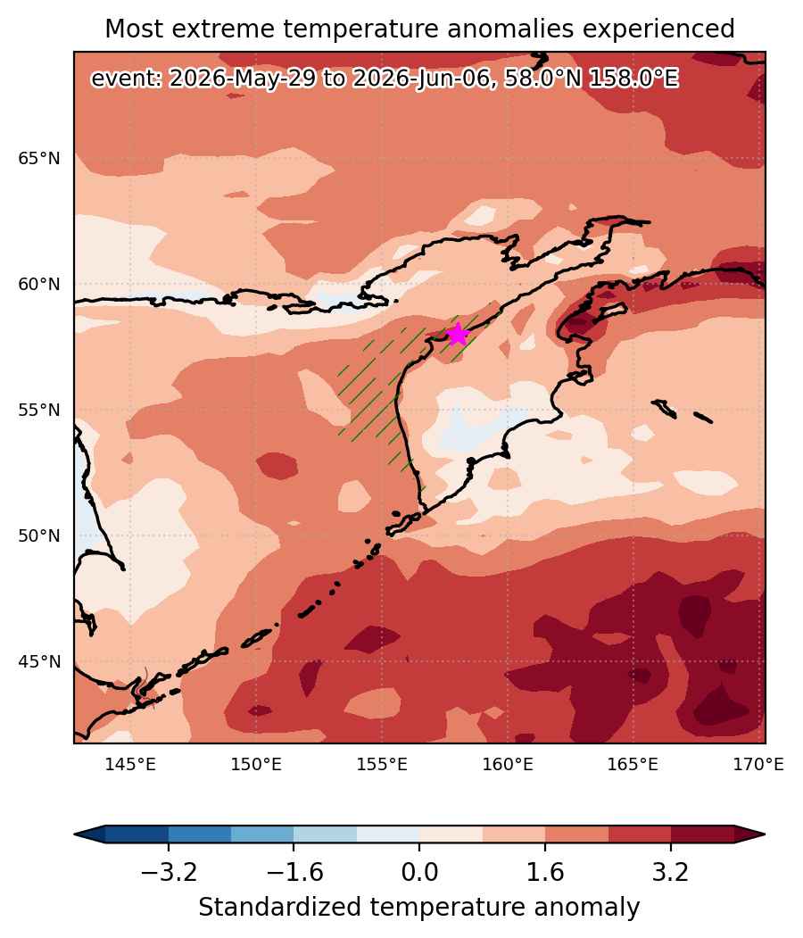
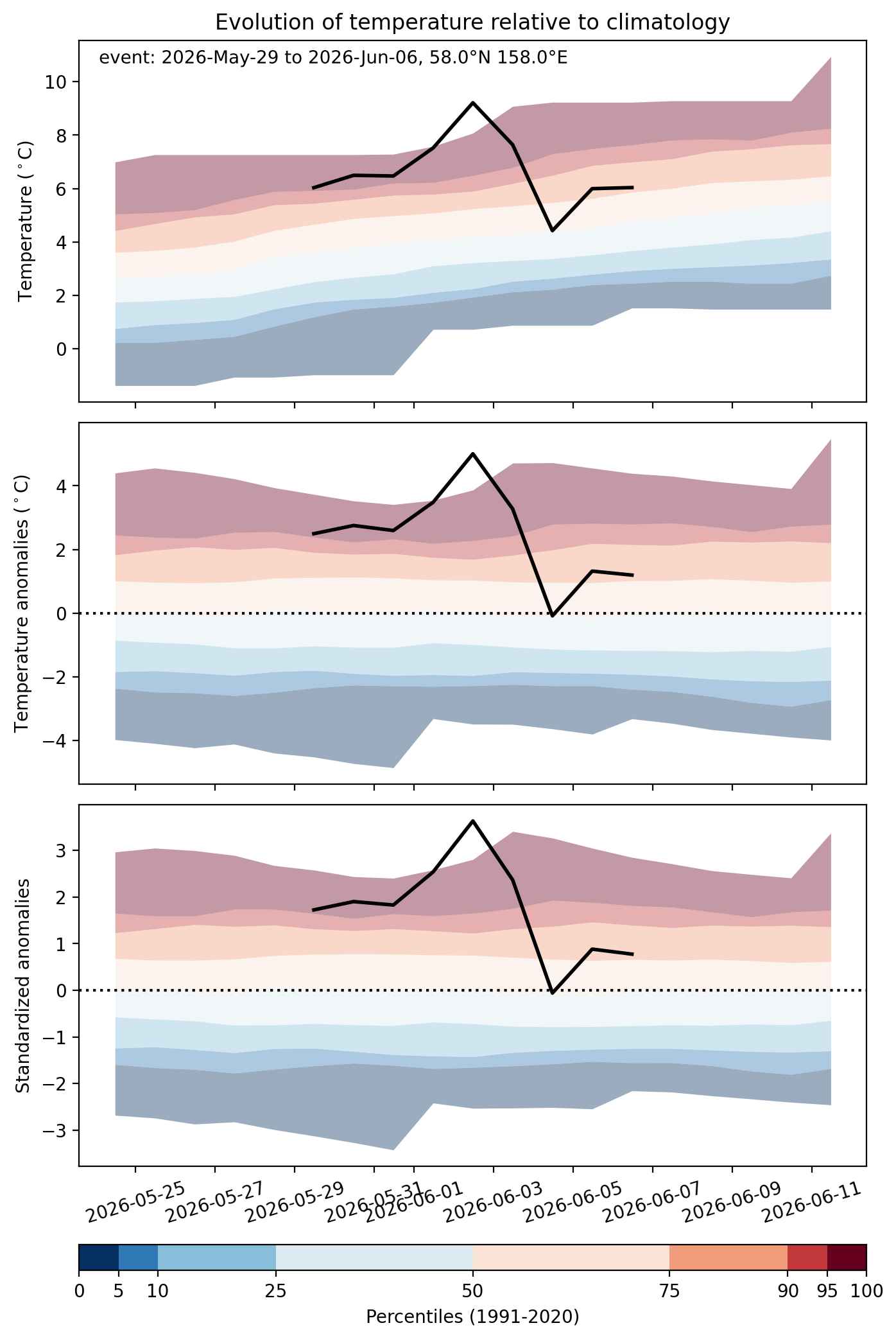
Heat wave occuring from May 29 2026 to June 06 2026 at 58.0°N 158.0°E

Download data: JSON

Event type: Heat wave

Countries affected (identified with ArcGIS Online; provided only for geographical reference):

  • Russian Federation

Duration: 9 days

Time span: May 29 2026 to June 06 2026

Statistics over entire affected area:

  • Mean temperature anomaly: 2.3 °C
  • Mean temperature: 6.7 °C
  • Maximum temperature anomaly: 6.4 °C
  • Maximum temperature: 14.3 °C

Event center: 58.0°N 158.0°E

Area affected: 86205 km$^2$


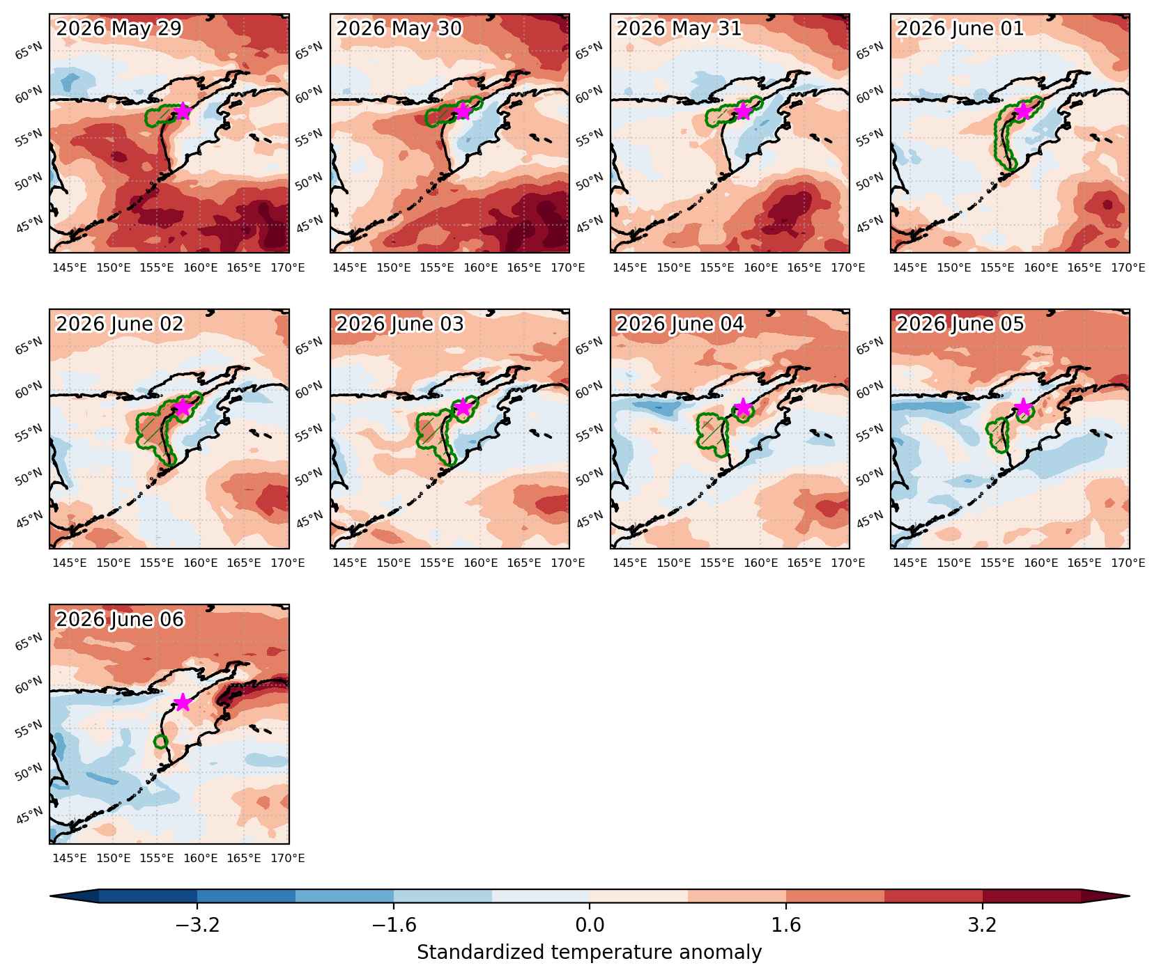
Fig. 1: Map of most extreme temperature anomalies (standardized) experienced during the event. The purple star indicates the center of the extreme event. Green hatching illustrates all areas under the effect of extremes at some time during the event.


Fig. 2: Evolution of temperature at the center of the event. The climatological percentile distribution is illustrated with color shadings.


Fig. 3: Maps illustrating the evolution of standardized temperature anomalies during the event.

Event ID: Heat_wave_2026-May-29_to_2026-Jun-06_158.0_58.0

Heat wave occuring from May 29 2026 to June 07 2026 at -34.0°S 295.0°E

Download data: JSON

Event type: Heat wave

Countries affected (identified with ArcGIS Online; provided only for geographical reference):

  • Argentina

Duration: 10 days

Time span: May 29 2026 to June 07 2026

Statistics over entire affected area:

  • Mean temperature anomaly: 4.8 °C
  • Mean temperature: 16.0 °C
  • Maximum temperature anomaly: 7.1 °C
  • Maximum temperature: 24.9 °C

Event center: -34.0°S 295.0°E

Area affected: 706602 km$^2$


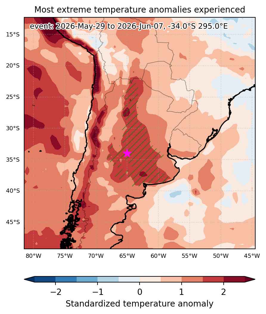
Fig. 1: Map of most extreme temperature anomalies (standardized) experienced during the event. The purple star indicates the center of the extreme event. Green hatching illustrates all areas under the effect of extremes at some time during the event.


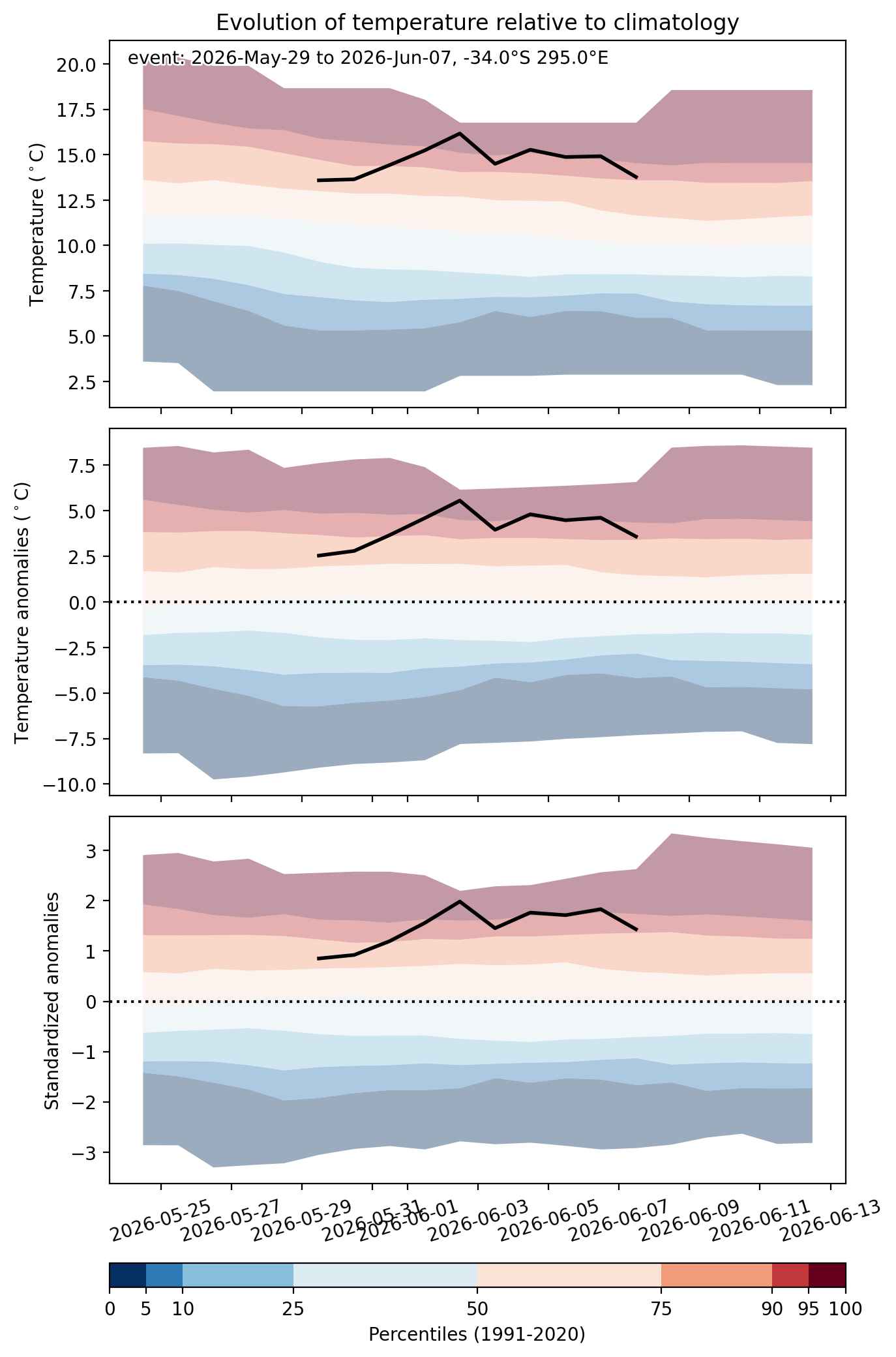
Fig. 2: Evolution of temperature at the center of the event. The climatological percentile distribution is illustrated with color shadings.


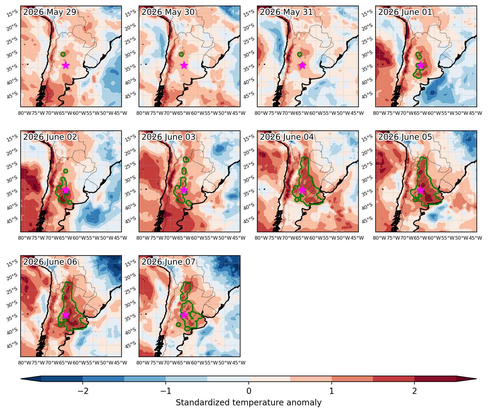
Fig. 3: Maps illustrating the evolution of standardized temperature anomalies during the event.

Event ID: Heat_wave_2026-May-29_to_2026-Jun-07_295.0_-34.0

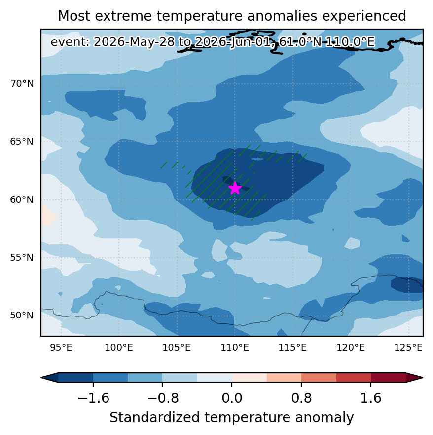
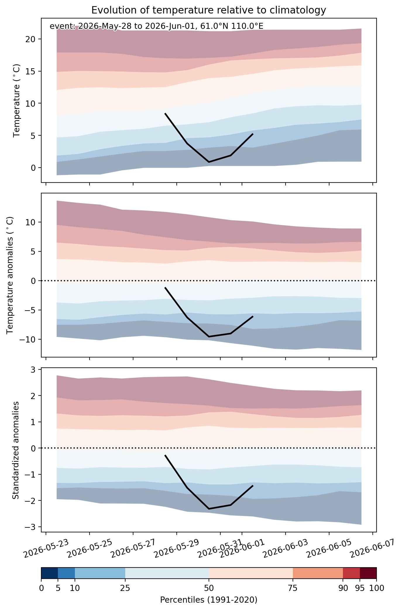
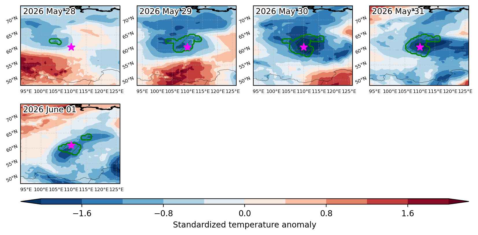
Cold spell occuring from May 28 2026 to June 01 2026 at 61.0°N 110.0°E

Download data: JSON

Event type: Cold spell

Countries affected (identified with ArcGIS Online; provided only for geographical reference):

  • Russian Federation

Duration: 5 days

Time span: May 28 2026 to June 01 2026

Statistics over entire affected area:

  • Mean temperature anomaly: -7.2 °C
  • Mean temperature: 3.1 °C
  • Minimum temperature anomaly: -10.1 °C
  • Minimum temperature: -0.3 °C

Event center: 61.0°N 110.0°E

Area affected: 182418 km$^2$


Fig. 1: Map of most extreme temperature anomalies (standardized) experienced during the event. The purple star indicates the center of the extreme event. Green hatching illustrates all areas under the effect of extremes at some time during the event.


Fig. 2: Evolution of temperature at the center of the event. The climatological percentile distribution is illustrated with color shadings.


Fig. 3: Maps illustrating the evolution of standardized temperature anomalies during the event.

Event ID: Cold_spell_2026-May-28_to_2026-Jun-01_110.0_61.0

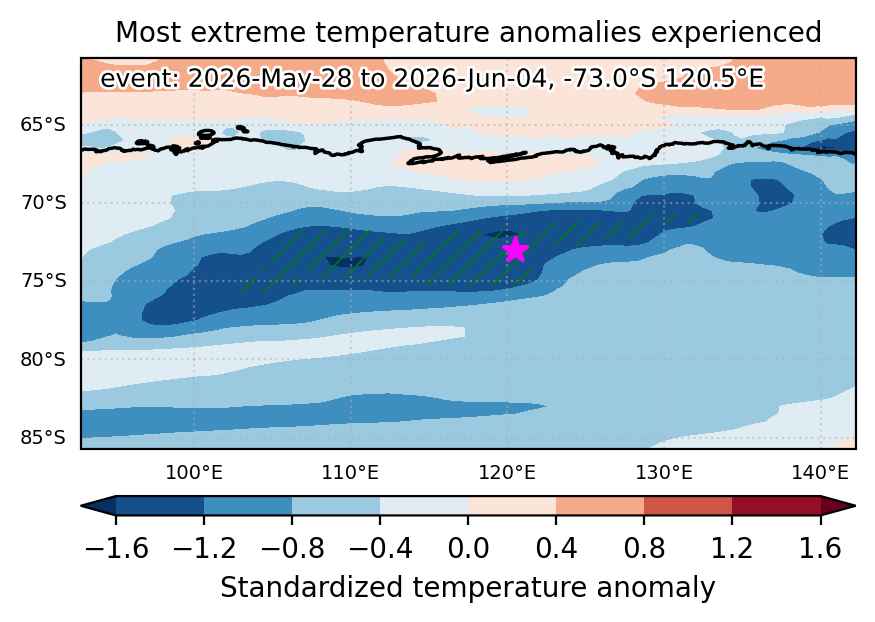
Cold spell occuring from May 28 2026 to June 04 2026 at -73.0°S 120.5°E

Download data: JSON

Event type: Cold spell

Countries affected (identified with ArcGIS Online; provided only for geographical reference):

  • Antarctica

Duration: 8 days

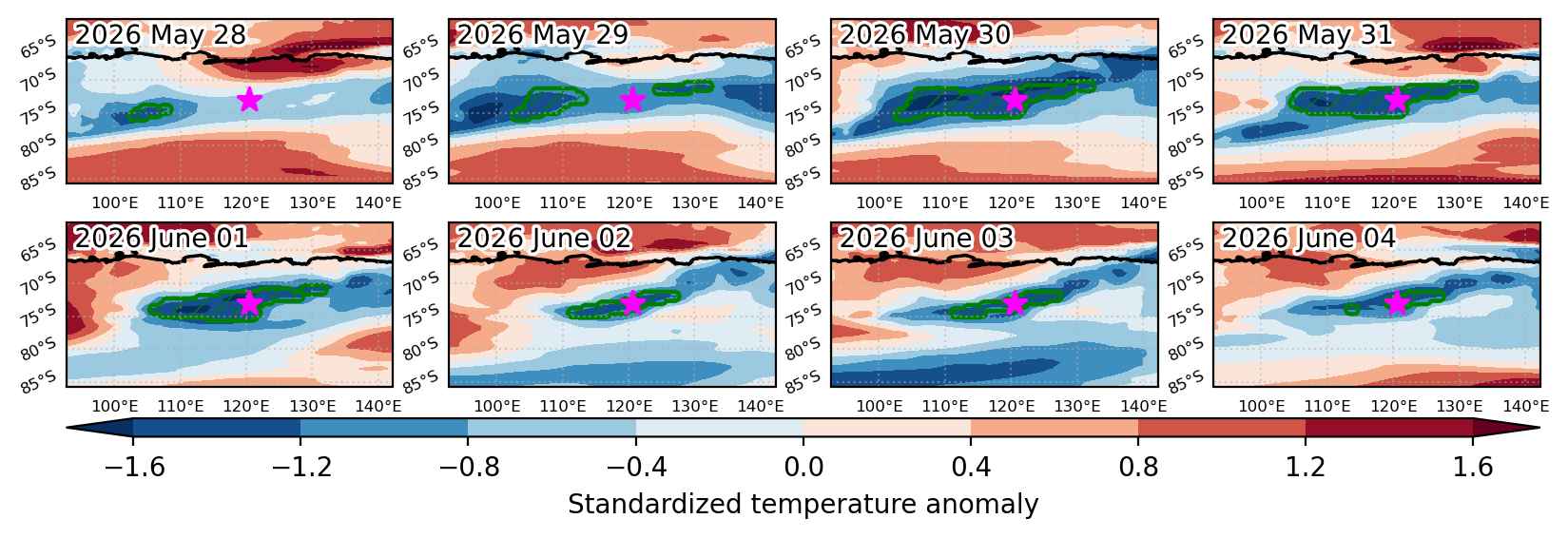
Time span: May 28 2026 to June 04 2026

Statistics over entire affected area:

  • Mean temperature anomaly: -8.7 °C
  • Mean temperature: -64.0 °C
  • Minimum temperature anomaly: -10.7 °C
  • Minimum temperature: -70.1 °C

Event center: -73.0°S 120.5°E

Area affected: 224680 km$^2$


Fig. 1: Map of most extreme temperature anomalies (standardized) experienced during the event. The purple star indicates the center of the extreme event. Green hatching illustrates all areas under the effect of extremes at some time during the event.


Fig. 2: Evolution of temperature at the center of the event. The climatological percentile distribution is illustrated with color shadings.


Fig. 3: Maps illustrating the evolution of standardized temperature anomalies during the event.

Event ID: Cold_spell_2026-May-28_to_2026-Jun-04_120.5_-73.0

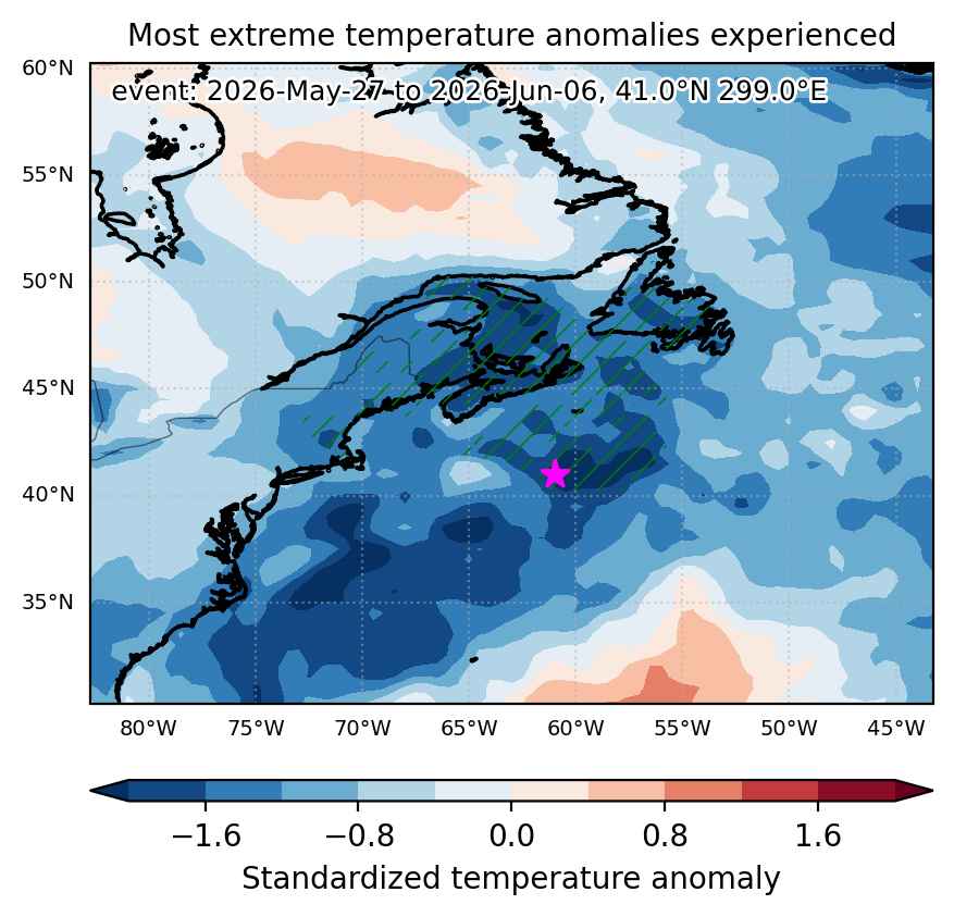
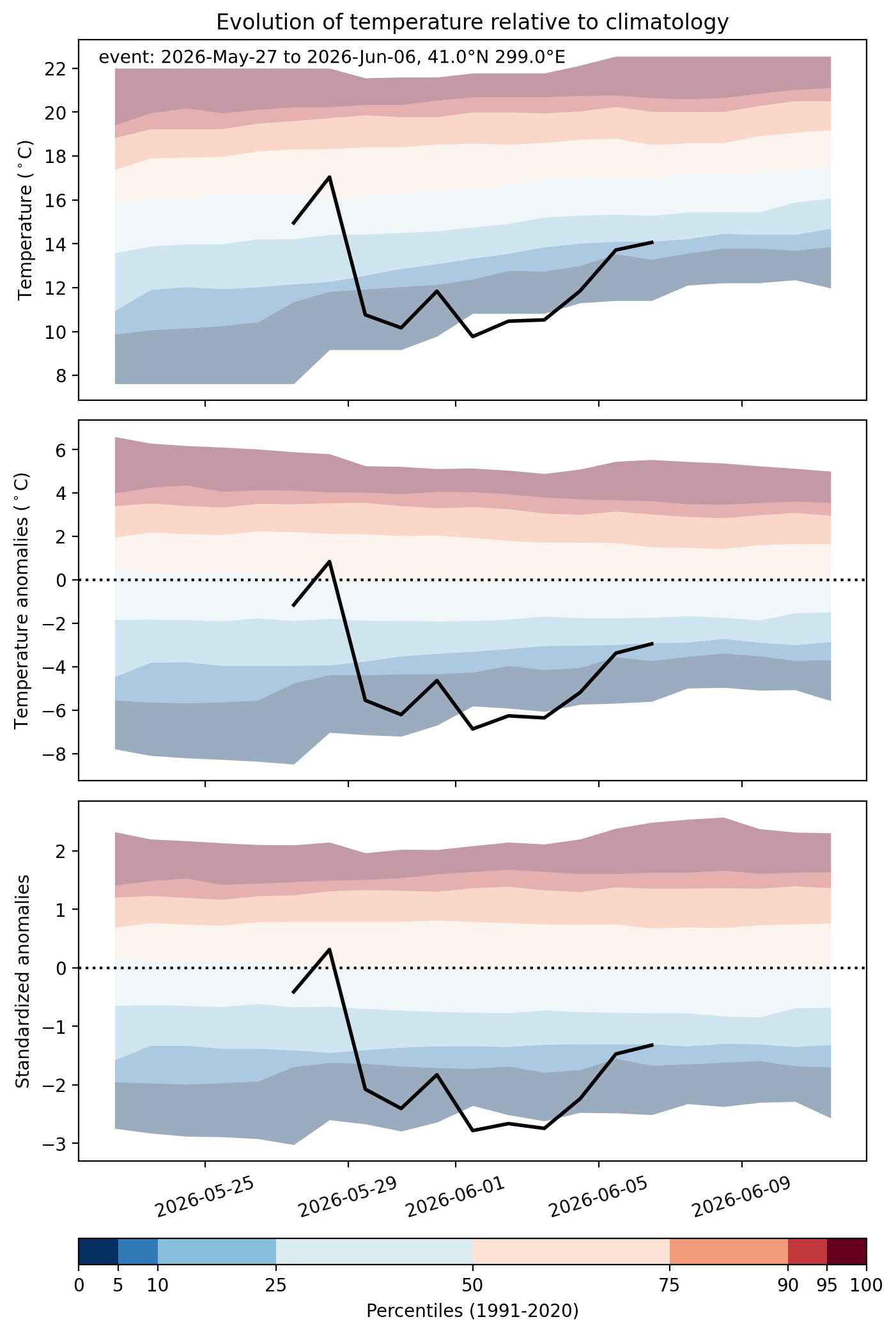
Cold spell occuring from May 27 2026 to June 06 2026 at 41.0°N 299.0°E

Download data: JSON

Event type: Cold spell

Countries affected (identified with ArcGIS Online; provided only for geographical reference):

  • Canada
  • United States

Duration: 11 days

Time span: May 27 2026 to June 06 2026

Statistics over entire affected area:

  • Mean temperature anomaly: -4.0 °C
  • Mean temperature: 6.6 °C
  • Minimum temperature anomaly: -7.9 °C
  • Minimum temperature: 2.2 °C

Event center: 41.0°N 299.0°E

Area affected: 710141 km$^2$


Fig. 1: Map of most extreme temperature anomalies (standardized) experienced during the event. The purple star indicates the center of the extreme event. Green hatching illustrates all areas under the effect of extremes at some time during the event.


Fig. 2: Evolution of temperature at the center of the event. The climatological percentile distribution is illustrated with color shadings.


Fig. 3: Maps illustrating the evolution of standardized temperature anomalies during the event.

Event ID: Cold_spell_2026-May-27_to_2026-Jun-06_299.0_41.0

Cold spell occuring from May 27 2026 to May 30 2026 at 33.0°N 245.0°E

Download data: JSON

Event type: Cold spell

Countries affected (identified with ArcGIS Online; provided only for geographical reference):

  • Mexico
  • United States

Duration: 4 days

Time span: May 27 2026 to May 30 2026

Statistics over entire affected area:

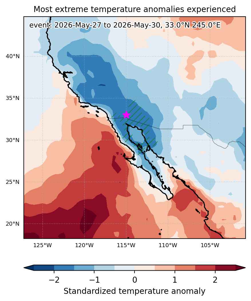
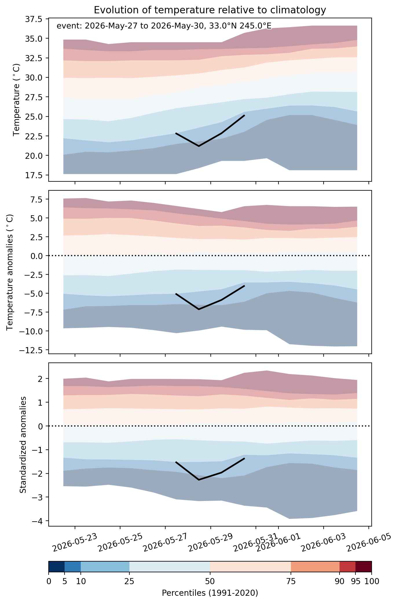
  • Mean temperature anomaly: -4.5 °C
  • Mean temperature: 22.0 °C
  • Minimum temperature anomaly: -7.2 °C
  • Minimum temperature: 11.8 °C

Event center: 33.0°N 245.0°E

Area affected: 142066 km$^2$


Fig. 1: Map of most extreme temperature anomalies (standardized) experienced during the event. The purple star indicates the center of the extreme event. Green hatching illustrates all areas under the effect of extremes at some time during the event.


Fig. 2: Evolution of temperature at the center of the event. The climatological percentile distribution is illustrated with color shadings.


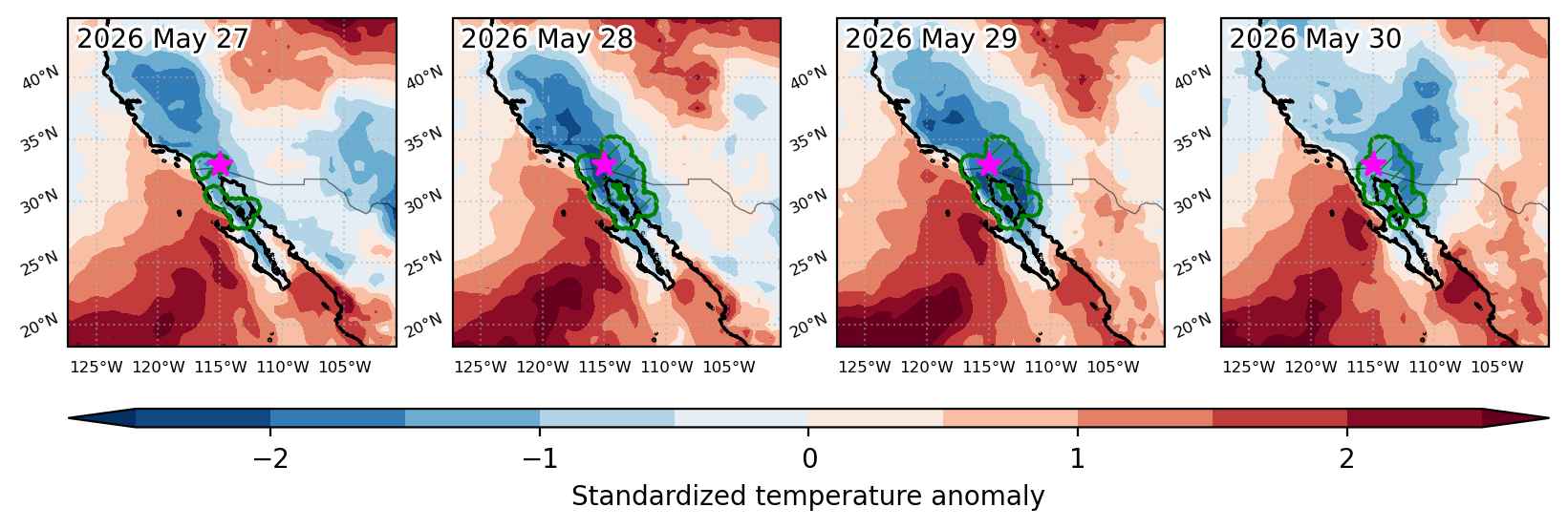
Fig. 3: Maps illustrating the evolution of standardized temperature anomalies during the event.

Event ID: Cold_spell_2026-May-27_to_2026-May-30_245.0_33.0

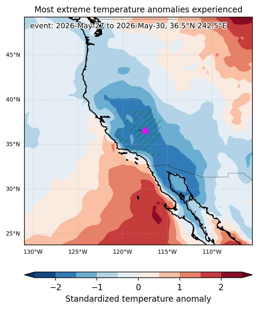
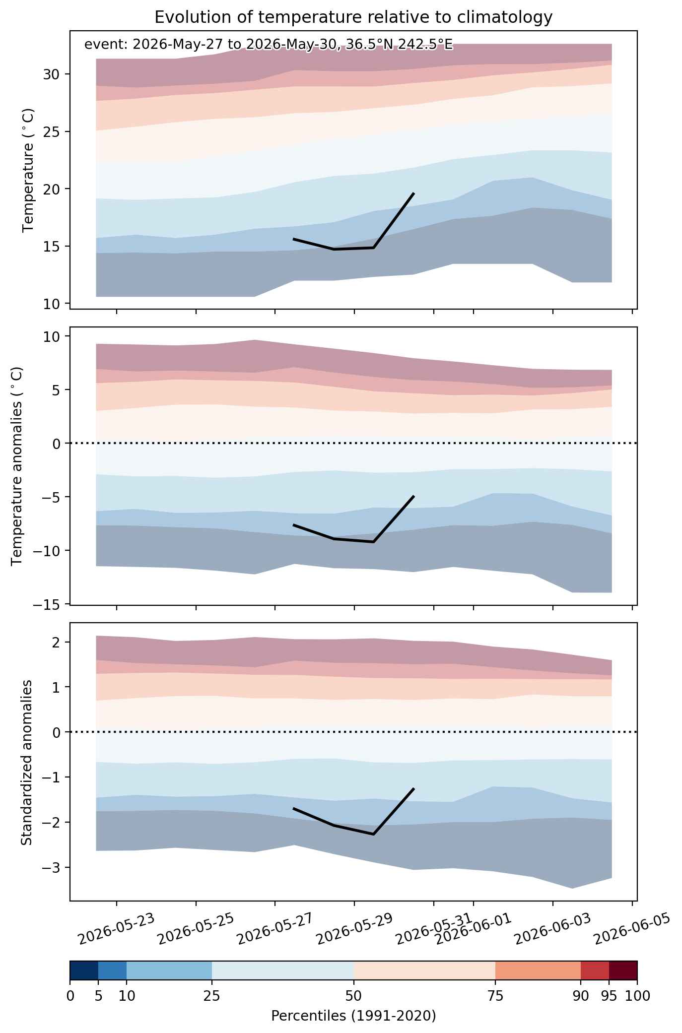
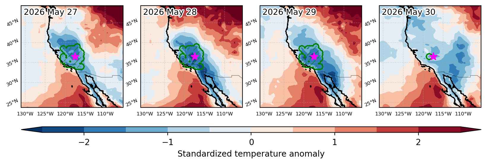
Cold spell occuring from May 27 2026 to May 30 2026 at 36.5°N 242.5°E

Download data: JSON

Event type: Cold spell

Countries affected (identified with ArcGIS Online; provided only for geographical reference):

  • United States

Duration: 4 days

Time span: May 27 2026 to May 30 2026

Statistics over entire affected area:

  • Mean temperature anomaly: -7.0 °C
  • Mean temperature: 11.7 °C
  • Minimum temperature anomaly: -9.6 °C
  • Minimum temperature: -1.9 °C

Event center: 36.5°N 242.5°E

Area affected: 144157 km$^2$


Fig. 1: Map of most extreme temperature anomalies (standardized) experienced during the event. The purple star indicates the center of the extreme event. Green hatching illustrates all areas under the effect of extremes at some time during the event.


Fig. 2: Evolution of temperature at the center of the event. The climatological percentile distribution is illustrated with color shadings.


Fig. 3: Maps illustrating the evolution of standardized temperature anomalies during the event.

Event ID: Cold_spell_2026-May-27_to_2026-May-30_242.5_36.5

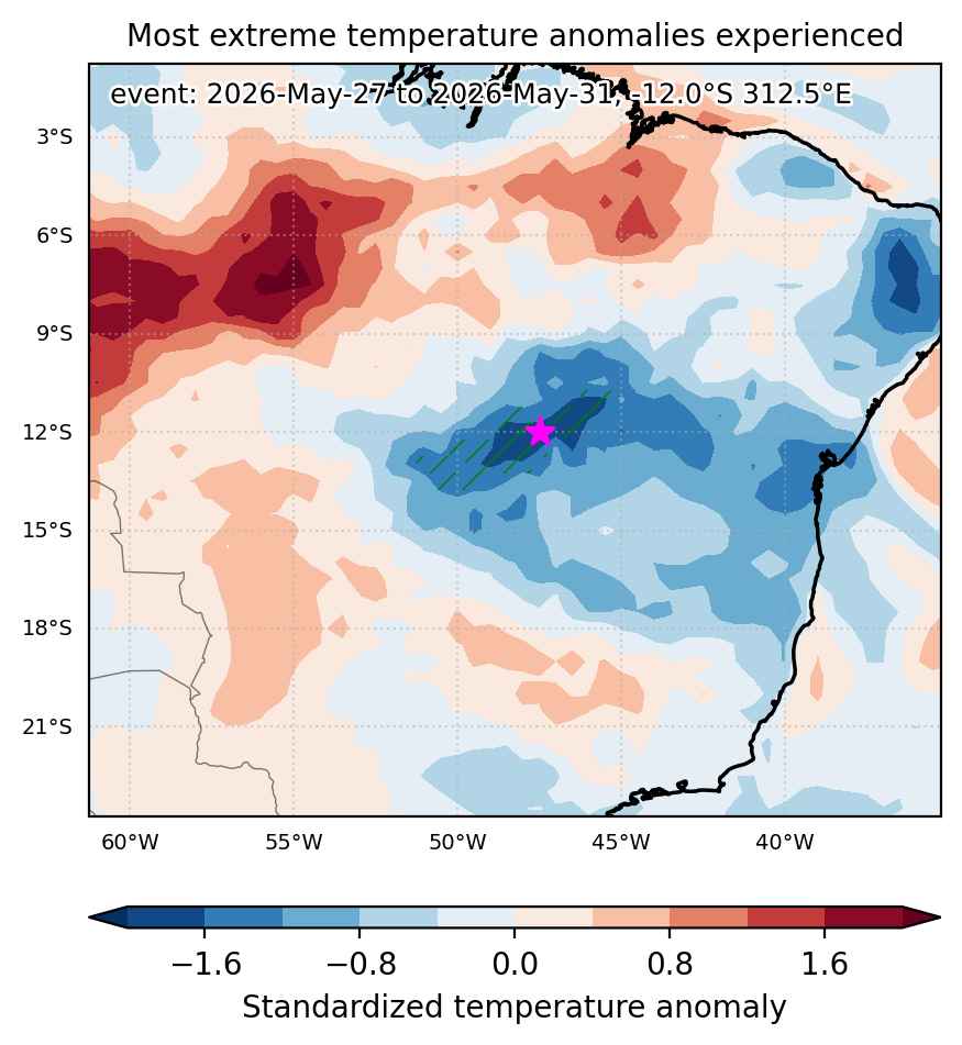
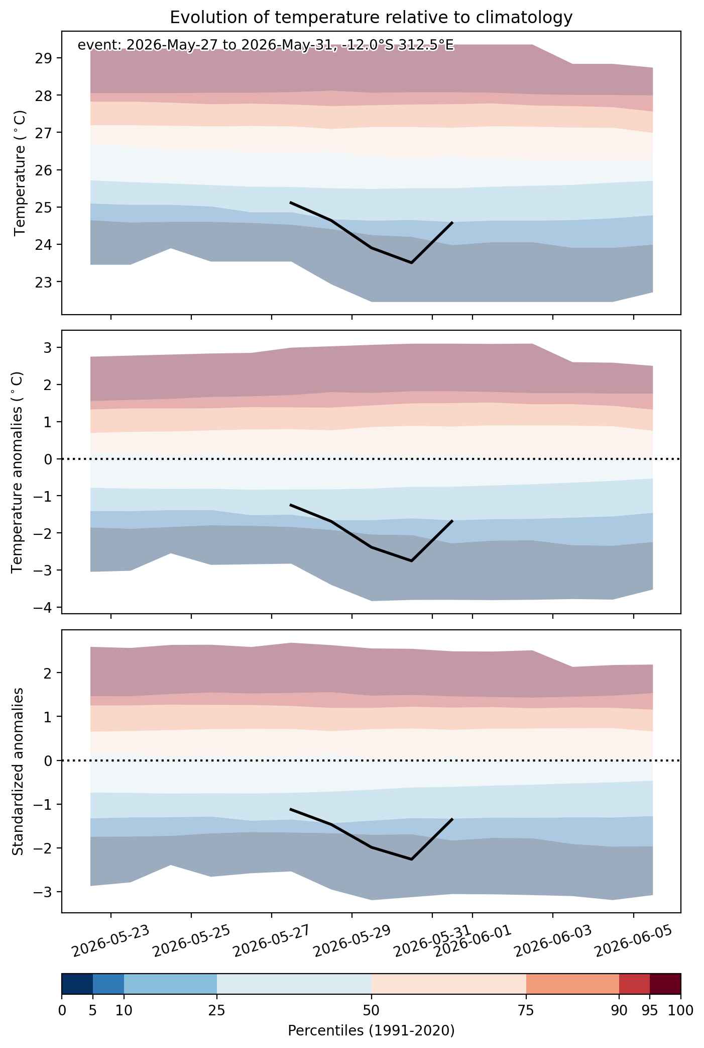
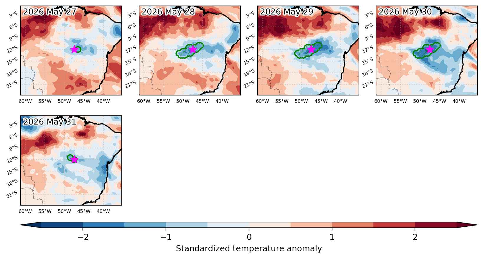
Cold spell occuring from May 27 2026 to May 31 2026 at -12.0°S 312.5°E

Download data: JSON

Event type: Cold spell

Countries affected (identified with ArcGIS Online; provided only for geographical reference):

  • Brazil

Duration: 5 days

Time span: May 27 2026 to May 31 2026

Statistics over entire affected area:

  • Mean temperature anomaly: -1.9 °C
  • Mean temperature: 24.1 °C
  • Minimum temperature anomaly: -2.8 °C
  • Minimum temperature: 20.9 °C

Event center: -12.0°S 312.5°E

Area affected: 78502 km$^2$


Fig. 1: Map of most extreme temperature anomalies (standardized) experienced during the event. The purple star indicates the center of the extreme event. Green hatching illustrates all areas under the effect of extremes at some time during the event.


Fig. 2: Evolution of temperature at the center of the event. The climatological percentile distribution is illustrated with color shadings.


Fig. 3: Maps illustrating the evolution of standardized temperature anomalies during the event.

Event ID: Cold_spell_2026-May-27_to_2026-May-31_312.5_-12.0