Heat wave occuring from June 17 2019 to June 20 2019 at -21.0°S 125.0°E

Download data: JSON

Event type: Heat wave

Countries affected (identified with ArcGIS Online; provided only for geographical reference):

  • Australia

Duration: 4 days

Time span: June 17 2019 to June 20 2019

Statistics over entire affected area:

  • Mean temperature anomaly: 4.7 °C
  • Mean temperature: 24.5 °C
  • Maximum temperature anomaly: 6.6 °C
  • Maximum temperature: 27.6 °C

Event center: -21.0°S 125.0°E

Area affected: 55248 km$^2$
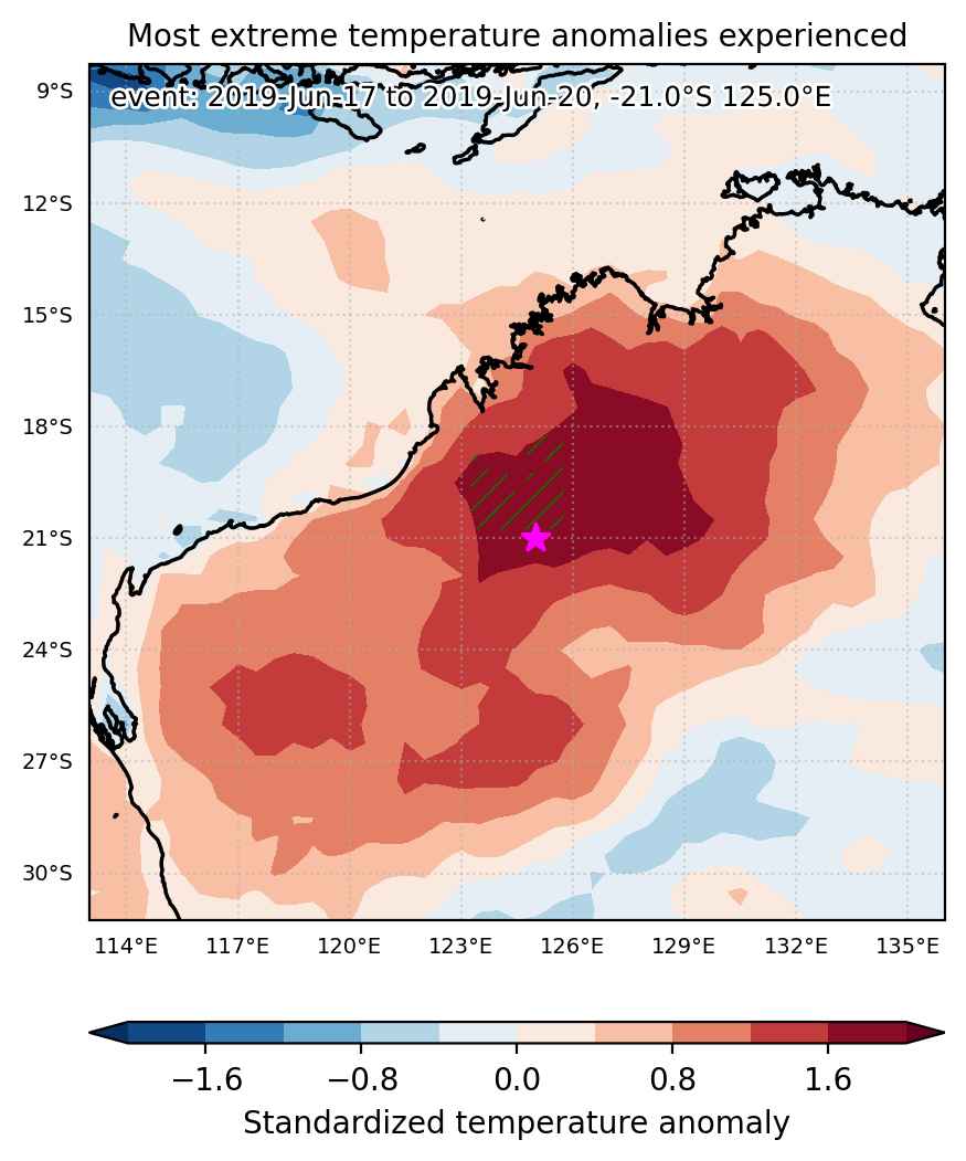

Fig. 1: Map of most extreme temperature anomalies (standardized) experienced during the event. The purple star indicates the center of the extreme event. Green hatching illustrates all areas under the effect of extremes at some time during the event.
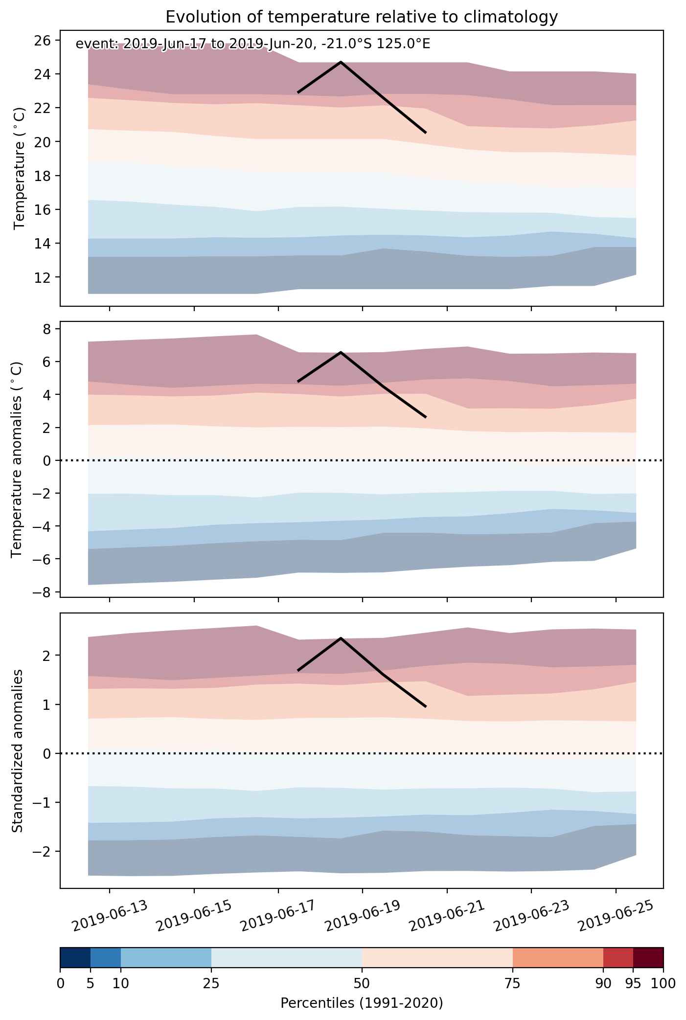


Fig. 2: Evolution of temperature at the center of the event. The climatological percentile distribution is illustrated with color shadings.
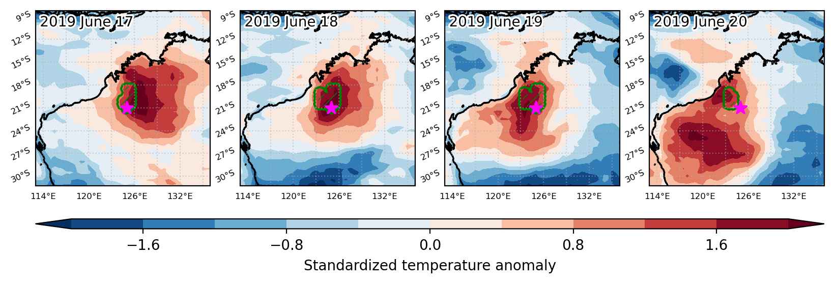


Fig. 3: Maps illustrating the evolution of standardized temperature anomalies during the event.

Event ID: Heat_wave_2019-Jun-17_to_2019-Jun-20_125.0_-21.0
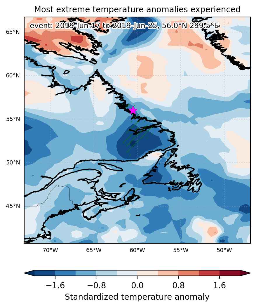
Cold spell occuring from June 17 2019 to June 25 2019 at 56.0°N 299.5°E

Download data: JSON

Event type: Cold spell

Countries affected (identified with ArcGIS Online; provided only for geographical reference):

  • Canada

Duration: 9 days

Time span: June 17 2019 to June 25 2019

Statistics over entire affected area:

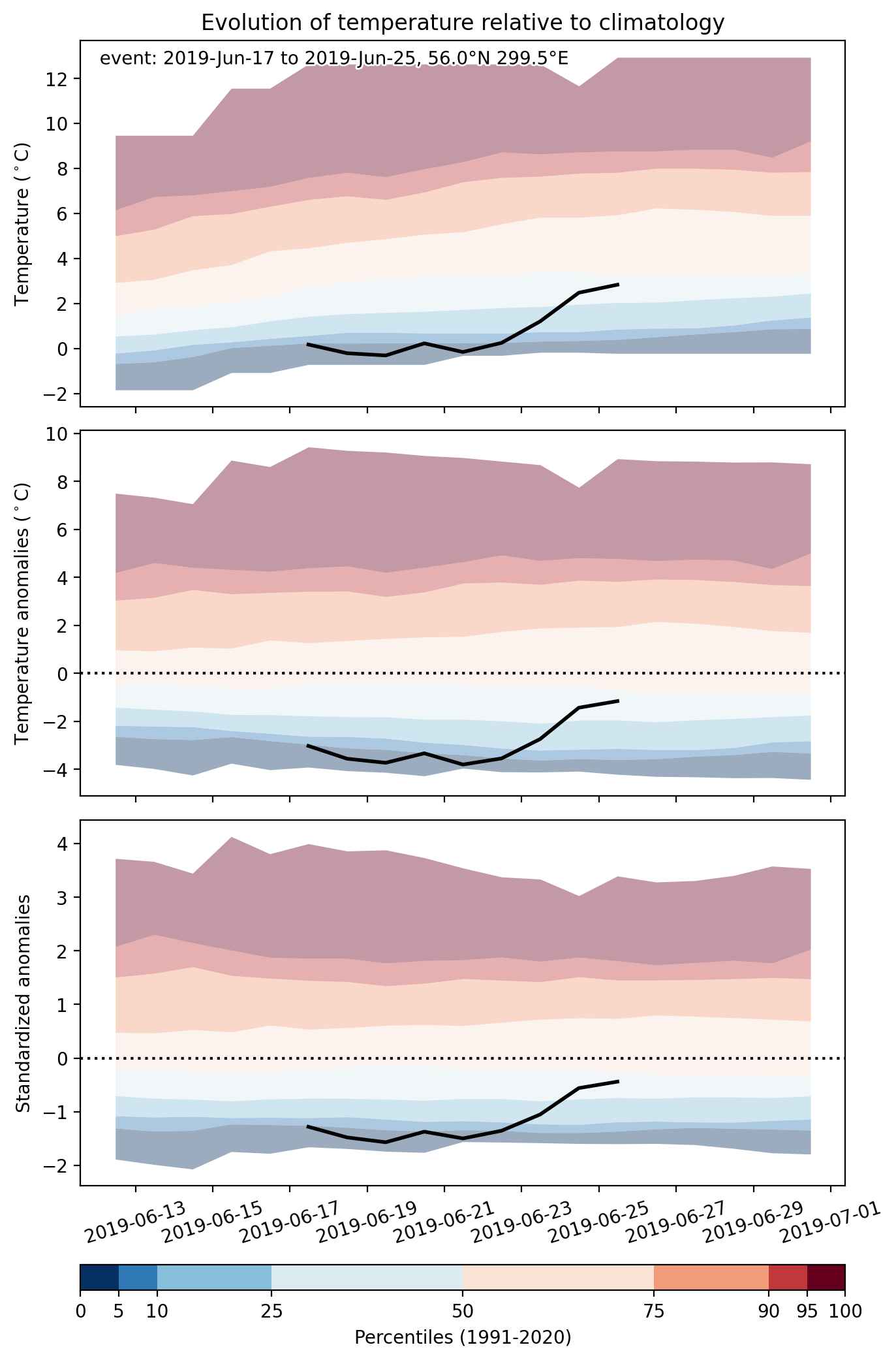
  • Mean temperature anomaly: -6.2 °C
  • Mean temperature: 4.2 °C
  • Minimum temperature anomaly: -9.6 °C
  • Minimum temperature: -0.3 °C

Event center: 56.0°N 299.5°E

Area affected: 56720 km$^2$


Fig. 1: Map of most extreme temperature anomalies (standardized) experienced during the event. The purple star indicates the center of the extreme event. Green hatching illustrates all areas under the effect of extremes at some time during the event.


Fig. 2: Evolution of temperature at the center of the event. The climatological percentile distribution is illustrated with color shadings.


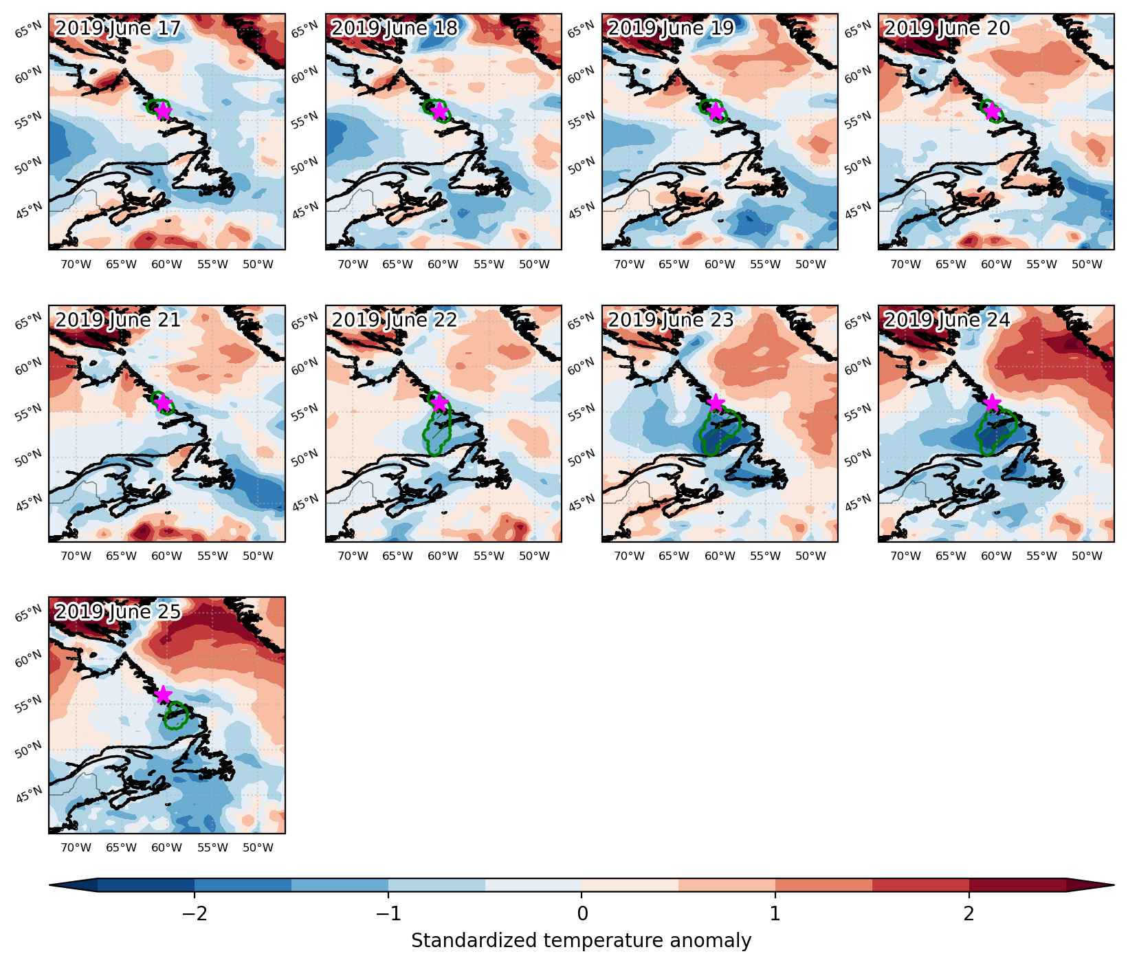
Fig. 3: Maps illustrating the evolution of standardized temperature anomalies during the event.

Event ID: Cold_spell_2019-Jun-17_to_2019-Jun-25_299.5_56.0

Cold spell occuring from June 17 2019 to June 23 2019 at 55.0°N 157.5°E

Download data: JSON

Event type: Cold spell

Countries affected (identified with ArcGIS Online; provided only for geographical reference):

  • Russian Federation

Duration: 7 days

Time span: June 17 2019 to June 23 2019

Statistics over entire affected area:

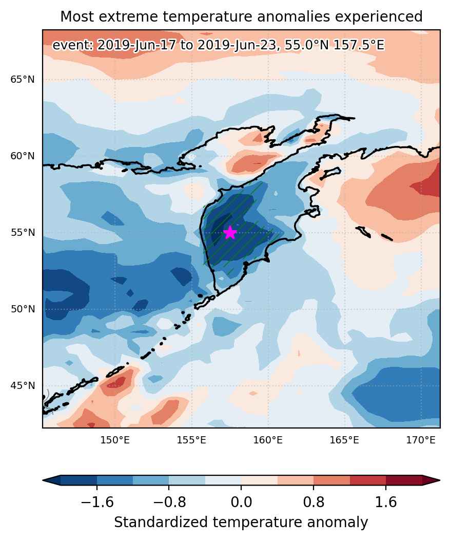
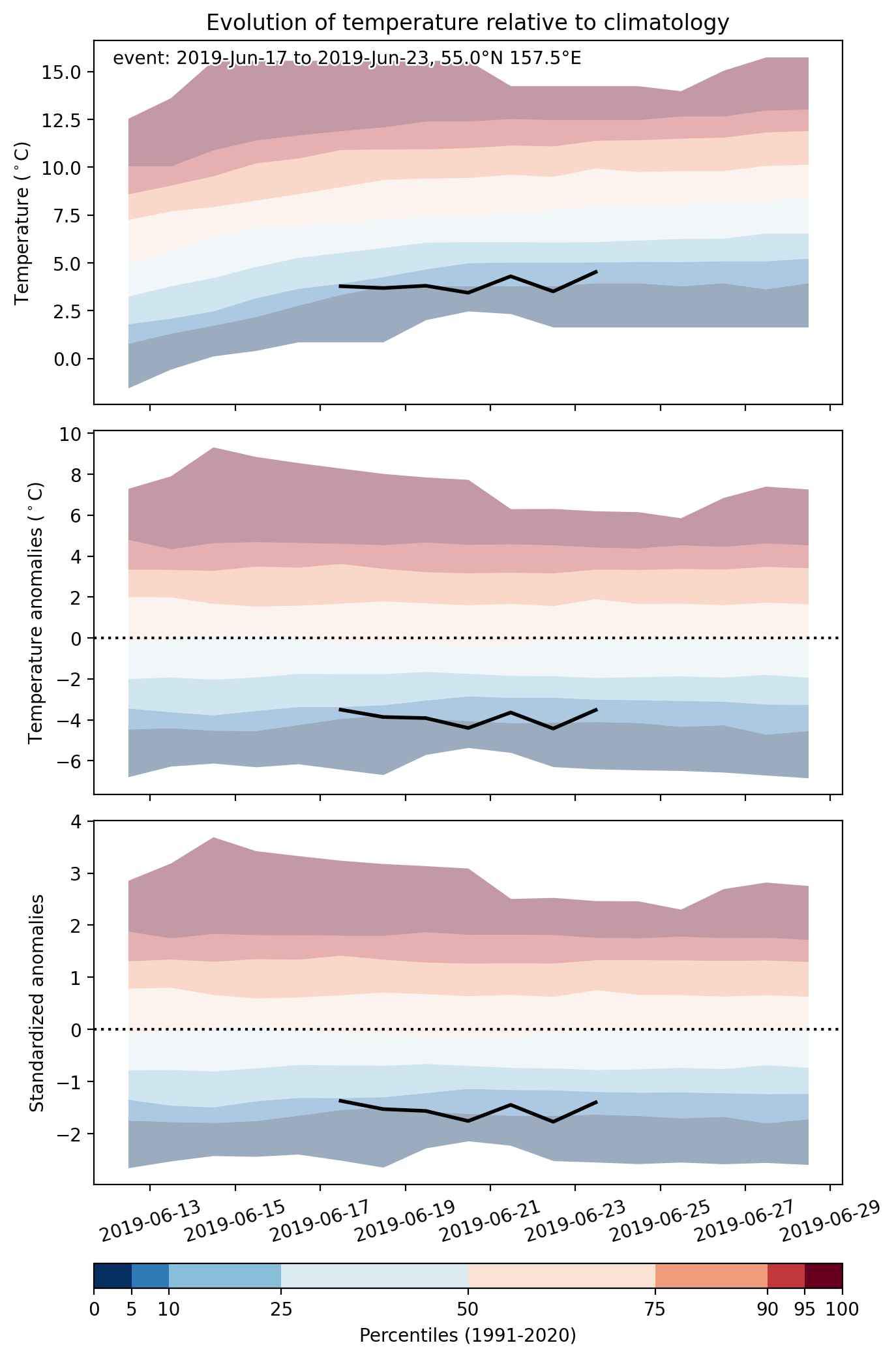
  • Mean temperature anomaly: -4.0 °C
  • Mean temperature: 6.2 °C
  • Minimum temperature anomaly: -5.7 °C
  • Minimum temperature: 2.0 °C

Event center: 55.0°N 157.5°E

Area affected: 120152 km$^2$


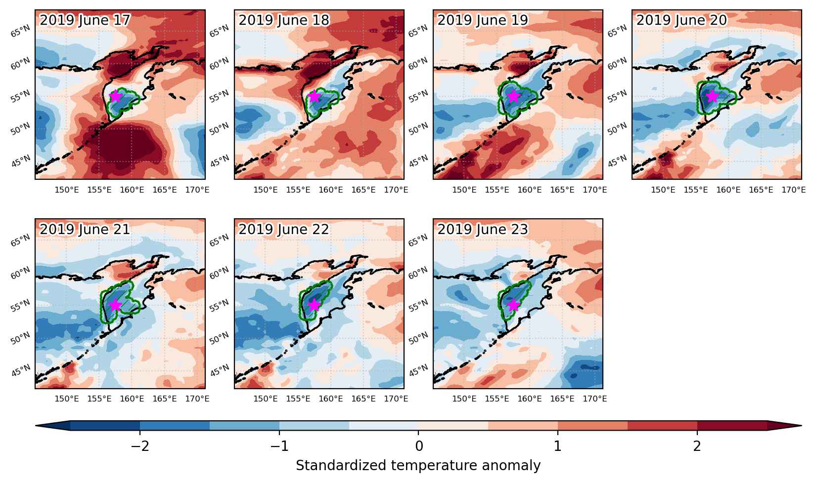
Fig. 1: Map of most extreme temperature anomalies (standardized) experienced during the event. The purple star indicates the center of the extreme event. Green hatching illustrates all areas under the effect of extremes at some time during the event.


Fig. 2: Evolution of temperature at the center of the event. The climatological percentile distribution is illustrated with color shadings.


Fig. 3: Maps illustrating the evolution of standardized temperature anomalies during the event.

Event ID: Cold_spell_2019-Jun-17_to_2019-Jun-23_157.5_55.0

Cold spell occuring from June 17 2019 to June 23 2019 at 35.0°N 86.0°E

Download data: JSON

Event type: Cold spell

Countries affected (identified with ArcGIS Online; provided only for geographical reference):

  • China

Duration: 7 days

Time span: June 17 2019 to June 23 2019

Statistics over entire affected area:

  • Mean temperature anomaly: -4.7 °C
  • Mean temperature: -3.9 °C
  • Minimum temperature anomaly: -8.1 °C
  • Minimum temperature: -8.5 °C

Event center: 35.0°N 86.0°E

Area affected: 80523 km$^2$


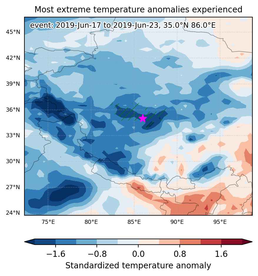
Fig. 1: Map of most extreme temperature anomalies (standardized) experienced during the event. The purple star indicates the center of the extreme event. Green hatching illustrates all areas under the effect of extremes at some time during the event.


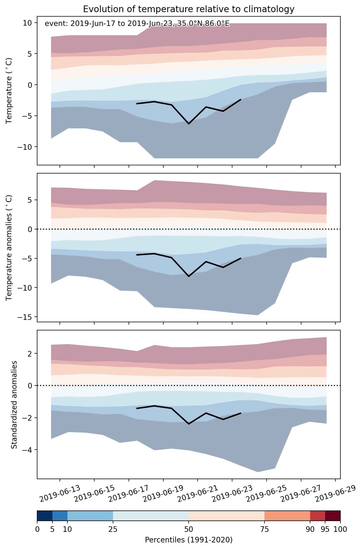
Fig. 2: Evolution of temperature at the center of the event. The climatological percentile distribution is illustrated with color shadings.


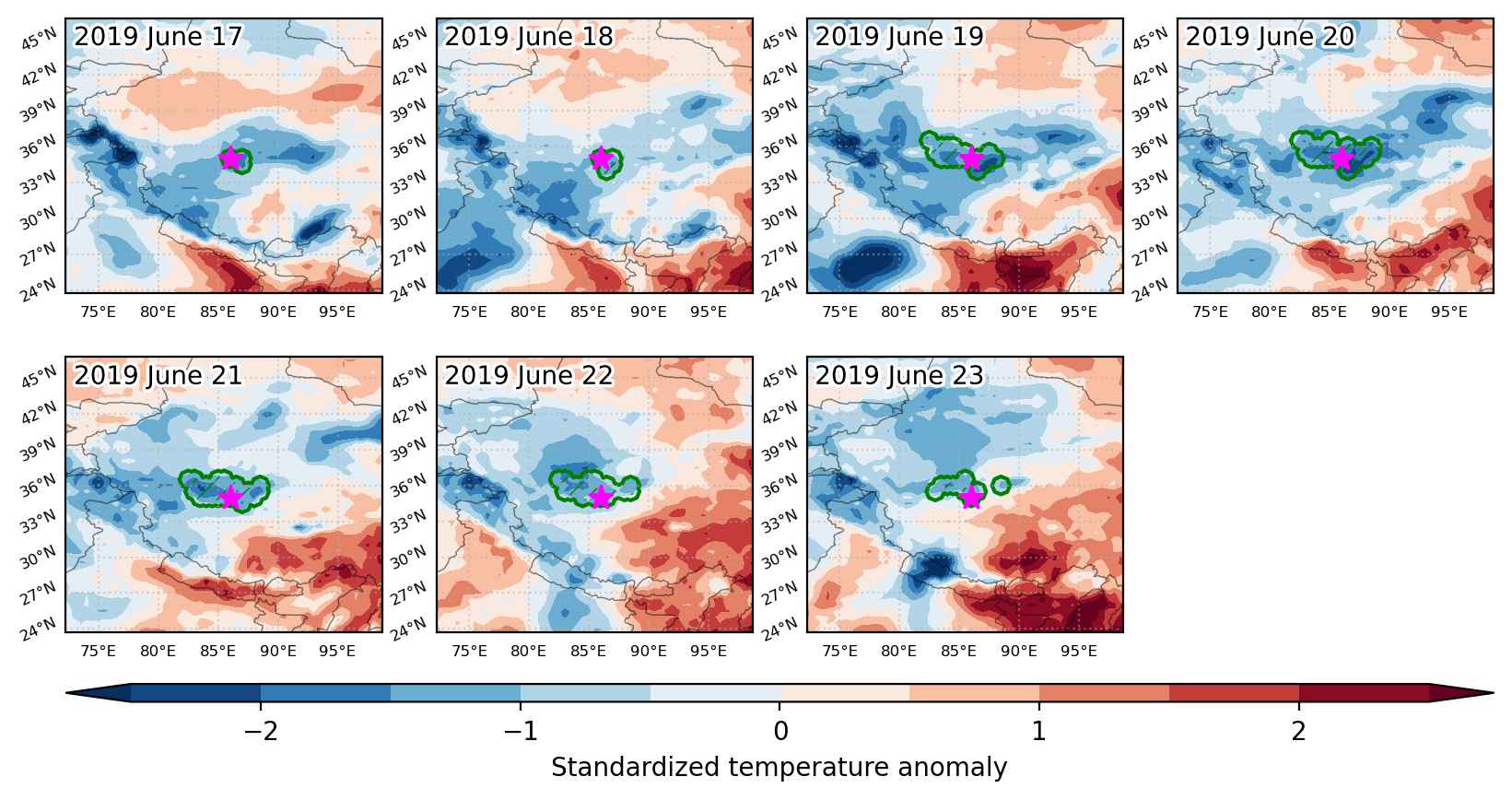
Fig. 3: Maps illustrating the evolution of standardized temperature anomalies during the event.

Event ID: Cold_spell_2019-Jun-17_to_2019-Jun-23_86.0_35.0

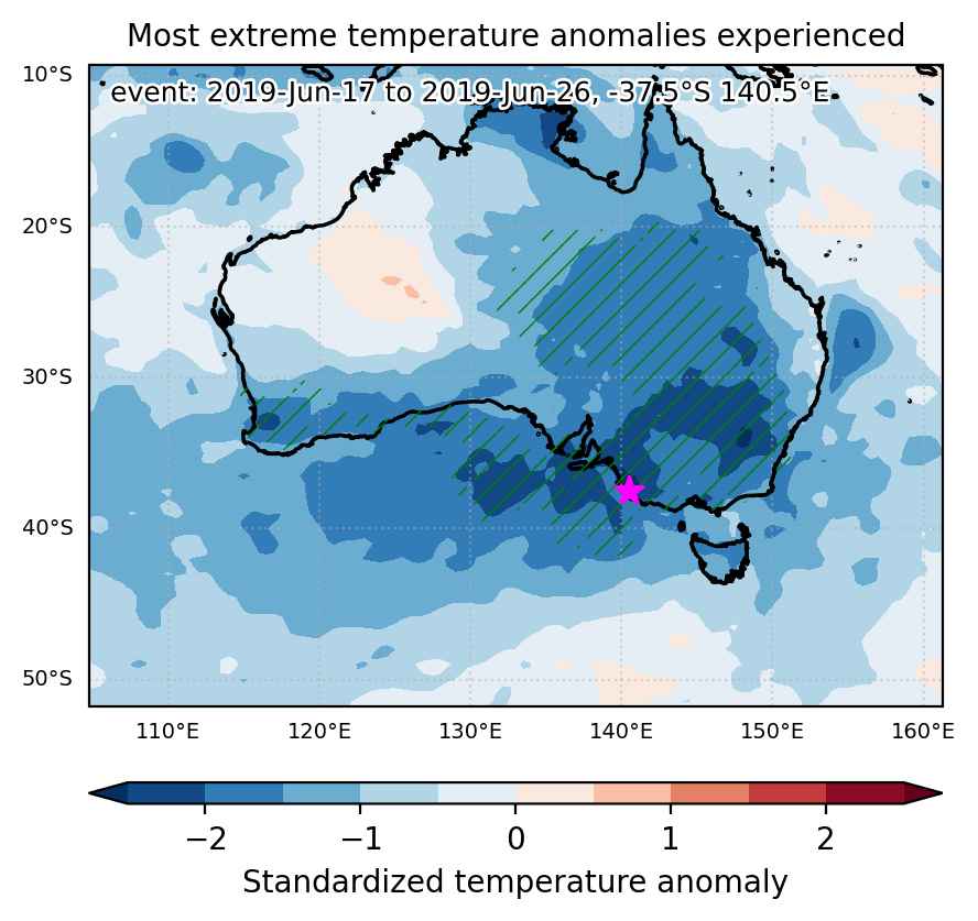
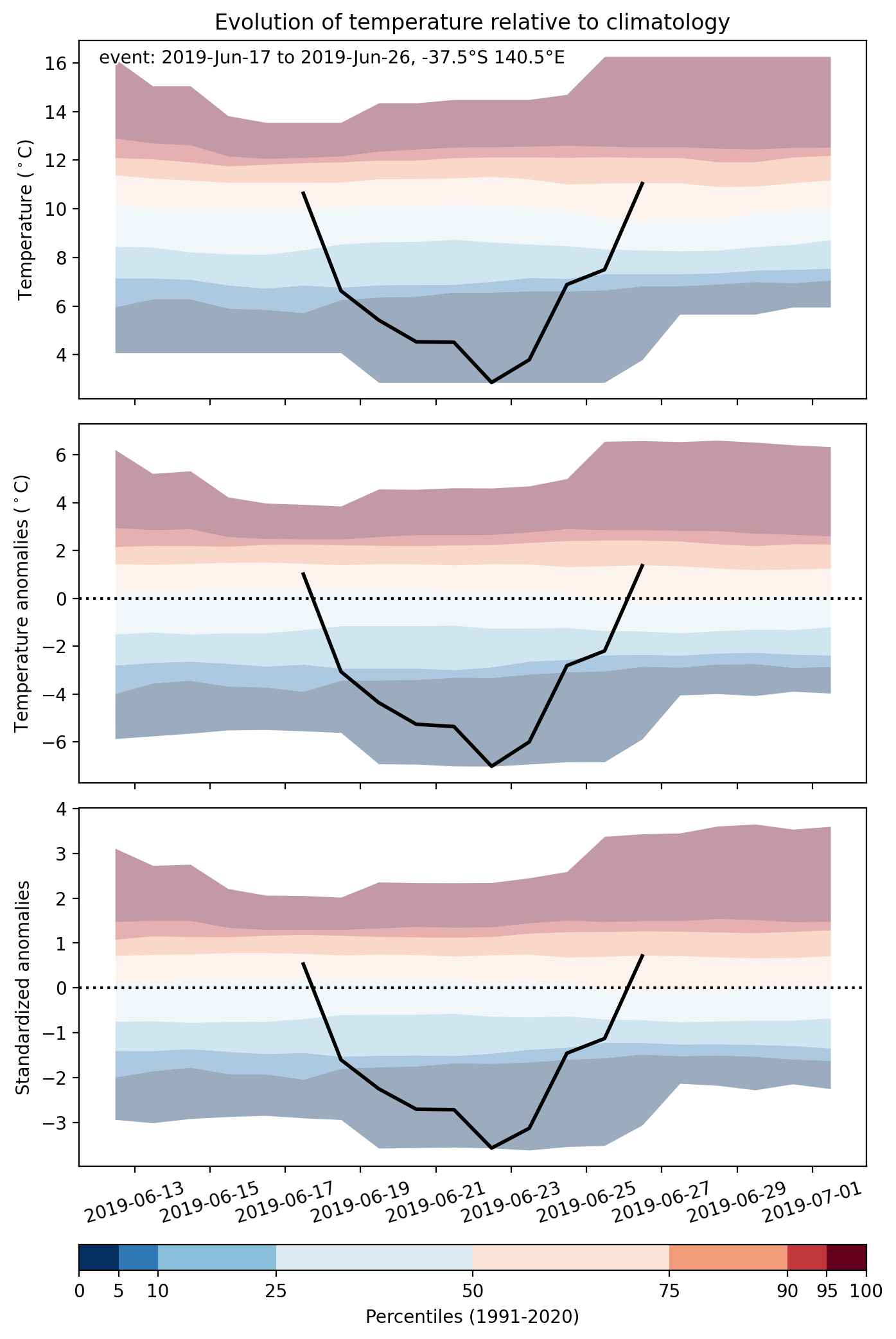
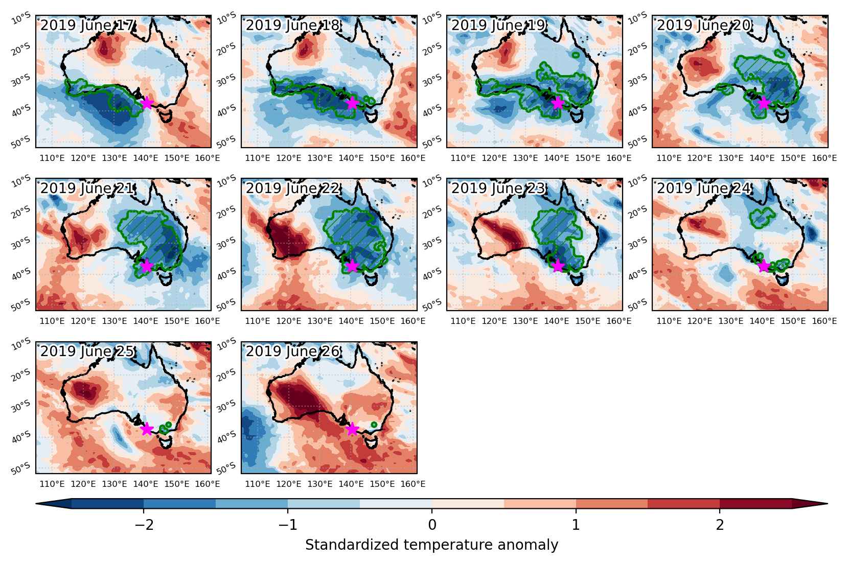
Cold spell occuring from June 17 2019 to June 26 2019 at -37.5°S 140.5°E

Download data: JSON

Event type: Cold spell

Countries affected (identified with ArcGIS Online; provided only for geographical reference):

  • Australia

Duration: 10 days

Time span: June 17 2019 to June 26 2019

Statistics over entire affected area:

  • Mean temperature anomaly: -3.9 °C
  • Mean temperature: 8.4 °C
  • Minimum temperature anomaly: -7.0 °C
  • Minimum temperature: -0.8 °C

Event center: -37.5°S 140.5°E

Area affected: 3201076 km$^2$


Fig. 1: Map of most extreme temperature anomalies (standardized) experienced during the event. The purple star indicates the center of the extreme event. Green hatching illustrates all areas under the effect of extremes at some time during the event.


Fig. 2: Evolution of temperature at the center of the event. The climatological percentile distribution is illustrated with color shadings.


Fig. 3: Maps illustrating the evolution of standardized temperature anomalies during the event.

Event ID: Cold_spell_2019-Jun-17_to_2019-Jun-26_140.5_-37.5

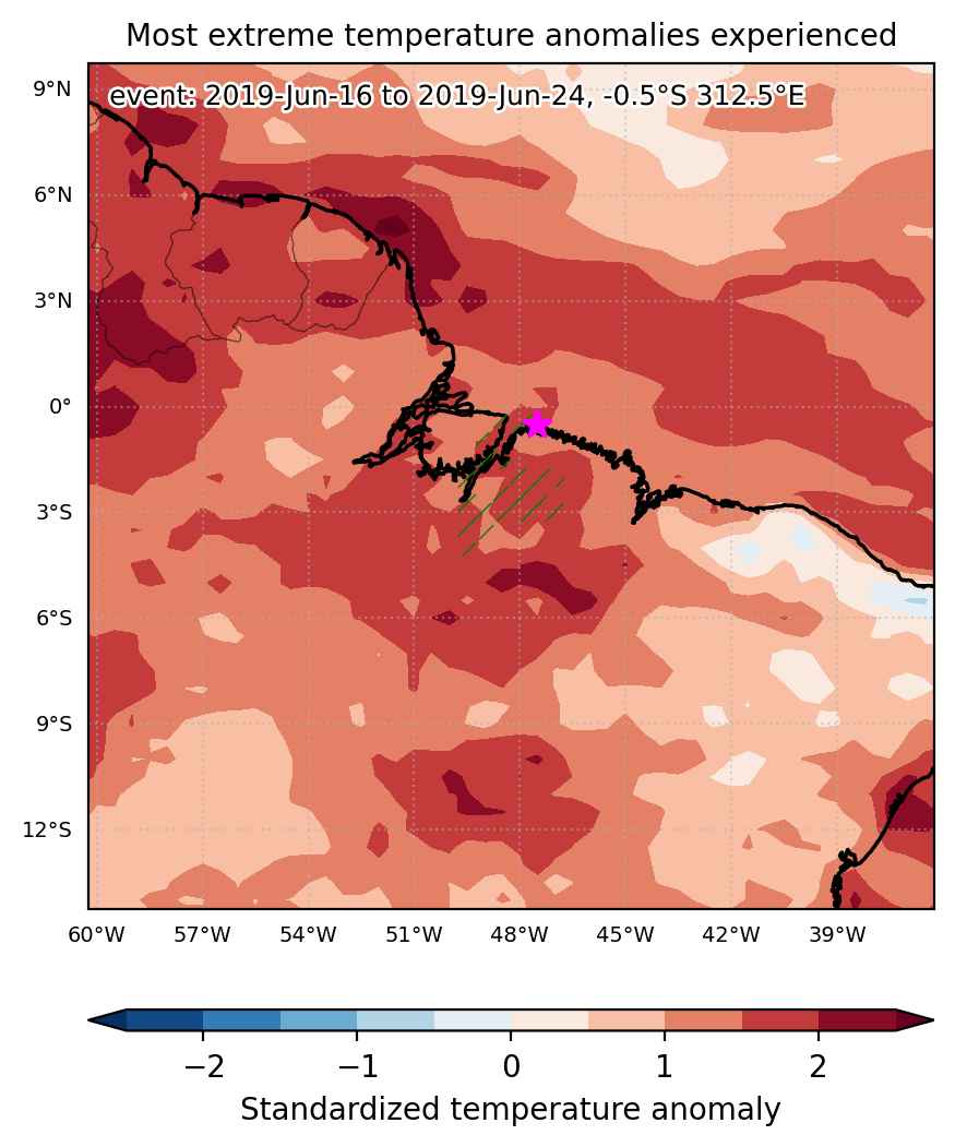
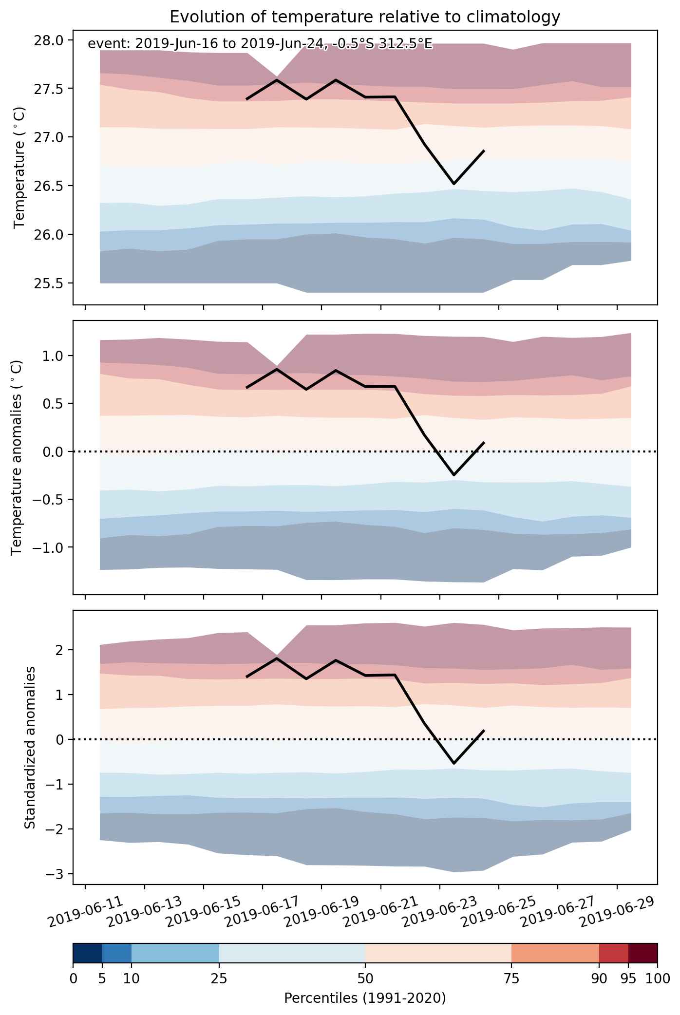
Heat wave occuring from June 16 2019 to June 24 2019 at -0.5°S 312.5°E

Download data: JSON

Event type: Heat wave

Countries affected (identified with ArcGIS Online; provided only for geographical reference):

  • Brazil

Duration: 9 days

Time span: June 16 2019 to June 24 2019

Statistics over entire affected area:

  • Mean temperature anomaly: 1.0 °C
  • Mean temperature: 27.7 °C
  • Maximum temperature anomaly: 1.6 °C
  • Maximum temperature: 29.0 °C

Event center: -0.5°S 312.5°E

Area affected: 71028 km$^2$


Fig. 1: Map of most extreme temperature anomalies (standardized) experienced during the event. The purple star indicates the center of the extreme event. Green hatching illustrates all areas under the effect of extremes at some time during the event.


Fig. 2: Evolution of temperature at the center of the event. The climatological percentile distribution is illustrated with color shadings.


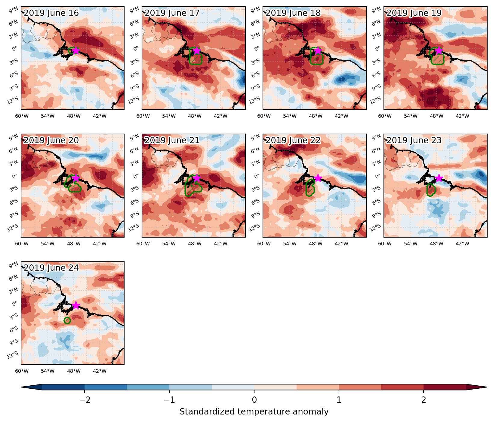
Fig. 3: Maps illustrating the evolution of standardized temperature anomalies during the event.

Event ID: Heat_wave_2019-Jun-16_to_2019-Jun-24_312.5_-0.5

Heat wave occuring from June 16 2019 to June 23 2019 at -6.5°S 148.5°E

Download data: JSON

Event type: Heat wave

Countries affected (identified with ArcGIS Online; provided only for geographical reference):

  • Papua New Guinea

Duration: 8 days

Time span: June 16 2019 to June 23 2019

Statistics over entire affected area:

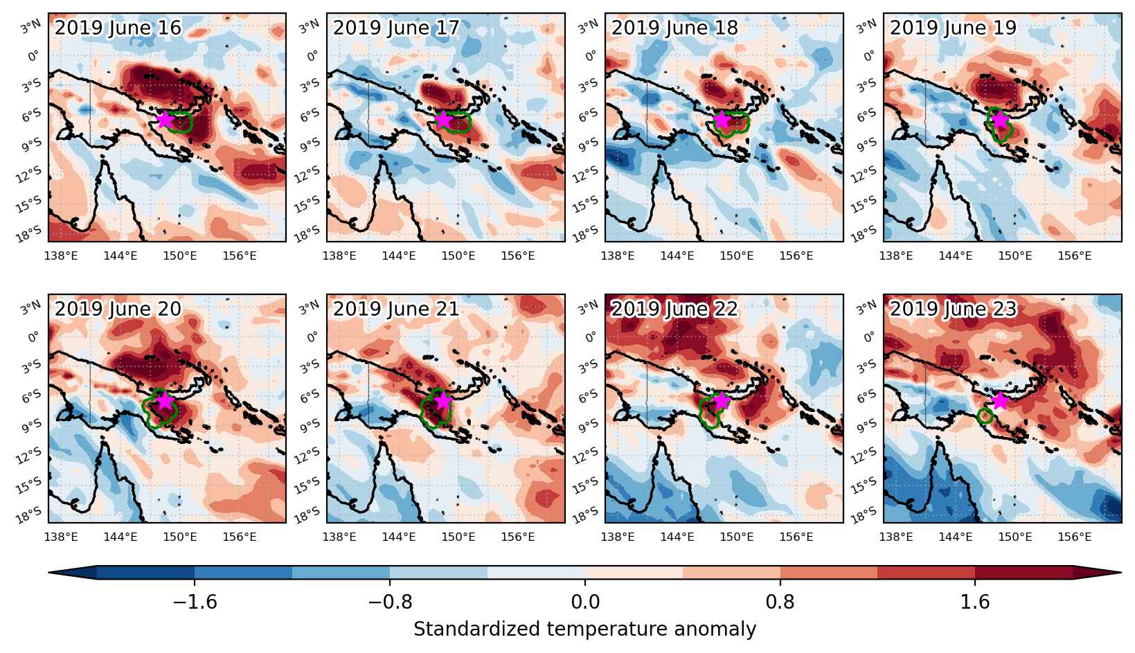
  • Mean temperature anomaly: 1.0 °C
  • Mean temperature: 26.2 °C
  • Maximum temperature anomaly: 1.9 °C
  • Maximum temperature: 28.0 °C

Event center: -6.5°S 148.5°E

Area affected: 61350 km$^2$


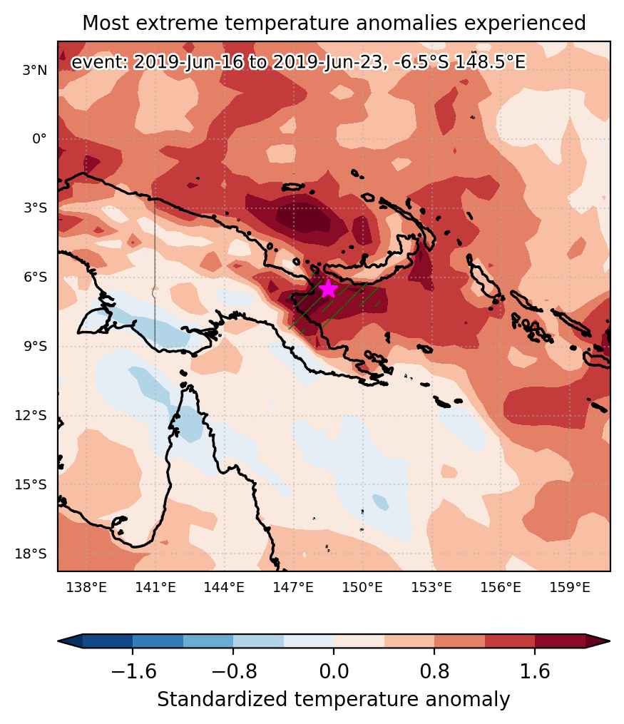
Fig. 1: Map of most extreme temperature anomalies (standardized) experienced during the event. The purple star indicates the center of the extreme event. Green hatching illustrates all areas under the effect of extremes at some time during the event.


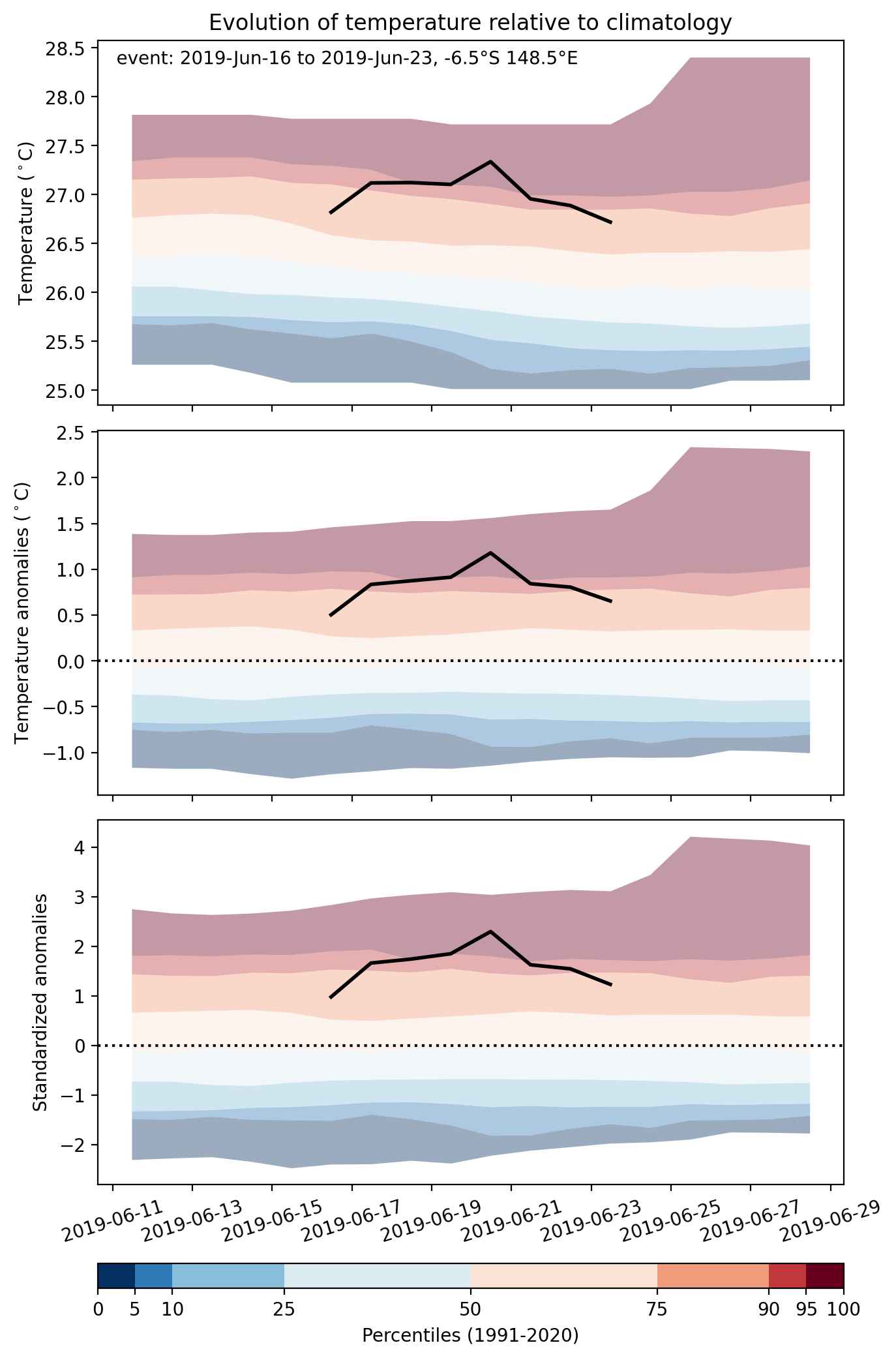
Fig. 2: Evolution of temperature at the center of the event. The climatological percentile distribution is illustrated with color shadings.


Fig. 3: Maps illustrating the evolution of standardized temperature anomalies during the event.

Event ID: Heat_wave_2019-Jun-16_to_2019-Jun-23_148.5_-6.5

Heat wave occuring from June 16 2019 to June 22 2019 at -46.5°S 288.5°E

Download data: JSON

Event type: Heat wave

Countries affected (identified with ArcGIS Online; provided only for geographical reference):

  • Argentina
  • Chile

Duration: 7 days

Time span: June 16 2019 to June 22 2019

Statistics over entire affected area:

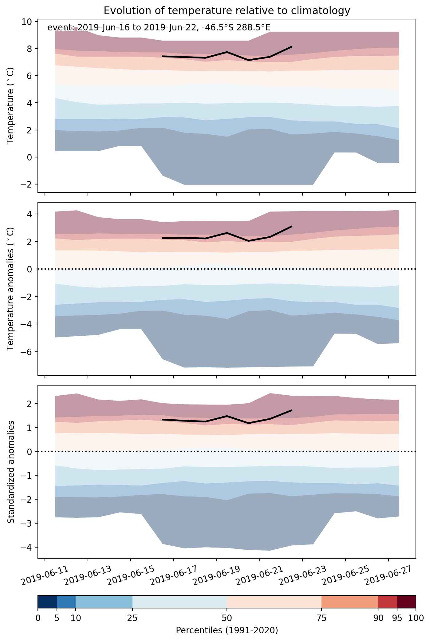
  • Mean temperature anomaly: 3.9 °C
  • Mean temperature: 4.9 °C
  • Maximum temperature anomaly: 6.1 °C
  • Maximum temperature: 10.1 °C

Event center: -46.5°S 288.5°E

Area affected: 69258 km$^2$


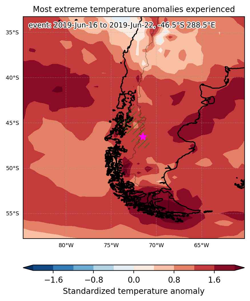
Fig. 1: Map of most extreme temperature anomalies (standardized) experienced during the event. The purple star indicates the center of the extreme event. Green hatching illustrates all areas under the effect of extremes at some time during the event.


Fig. 2: Evolution of temperature at the center of the event. The climatological percentile distribution is illustrated with color shadings.


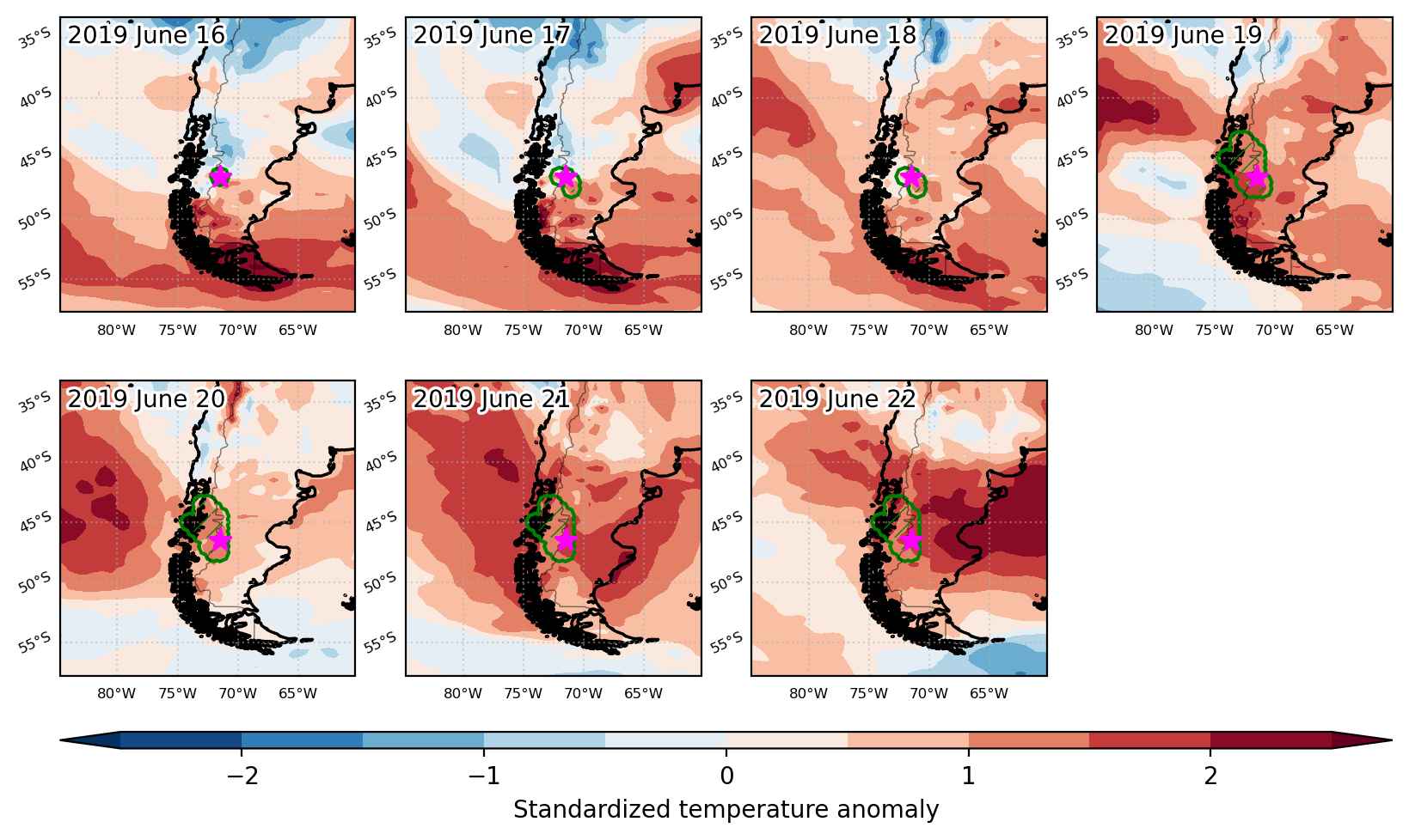
Fig. 3: Maps illustrating the evolution of standardized temperature anomalies during the event.

Event ID: Heat_wave_2019-Jun-16_to_2019-Jun-22_288.5_-46.5

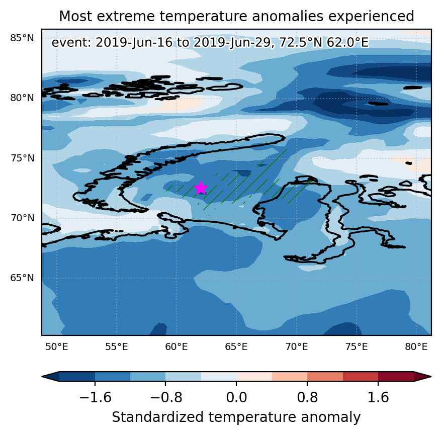
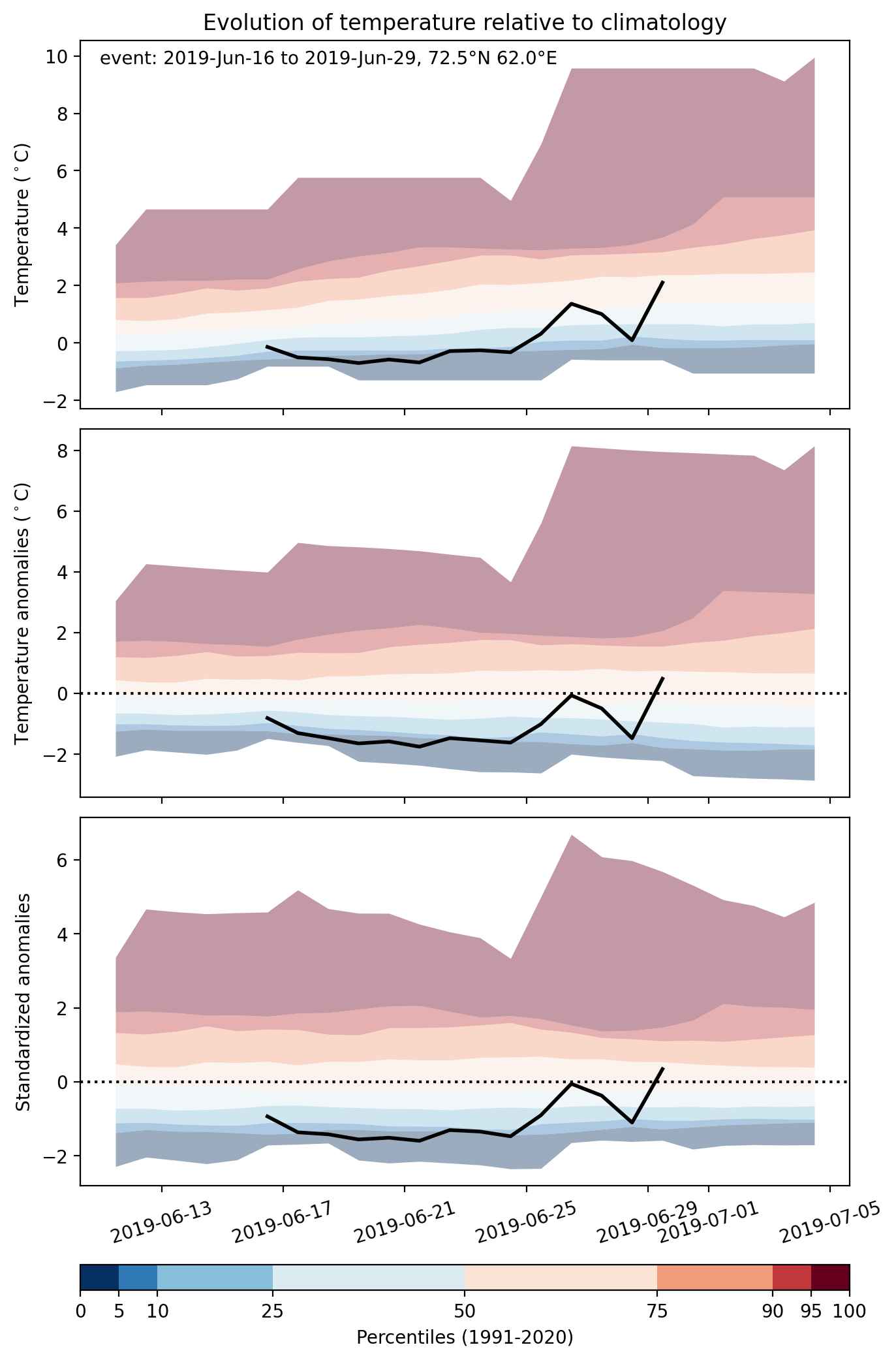
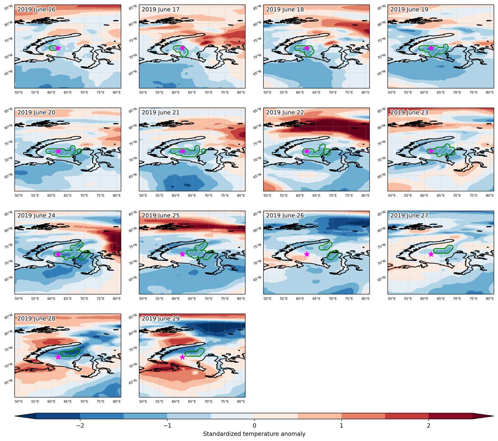
Cold spell occuring from June 16 2019 to June 29 2019 at 72.5°N 62.0°E

Download data: JSON

Event type: Cold spell

Countries affected (identified with ArcGIS Online; provided only for geographical reference):

  • Russian Federation

Duration: 14 days

Time span: June 16 2019 to June 29 2019

Statistics over entire affected area:

  • Mean temperature anomaly: -1.8 °C
  • Mean temperature: -0.3 °C
  • Minimum temperature anomaly: -6.8 °C
  • Minimum temperature: -1.5 °C

Event center: 72.5°N 62.0°E

Area affected: 74867 km$^2$


Fig. 1: Map of most extreme temperature anomalies (standardized) experienced during the event. The purple star indicates the center of the extreme event. Green hatching illustrates all areas under the effect of extremes at some time during the event.


Fig. 2: Evolution of temperature at the center of the event. The climatological percentile distribution is illustrated with color shadings.


Fig. 3: Maps illustrating the evolution of standardized temperature anomalies during the event.

Event ID: Cold_spell_2019-Jun-16_to_2019-Jun-29_62.0_72.5

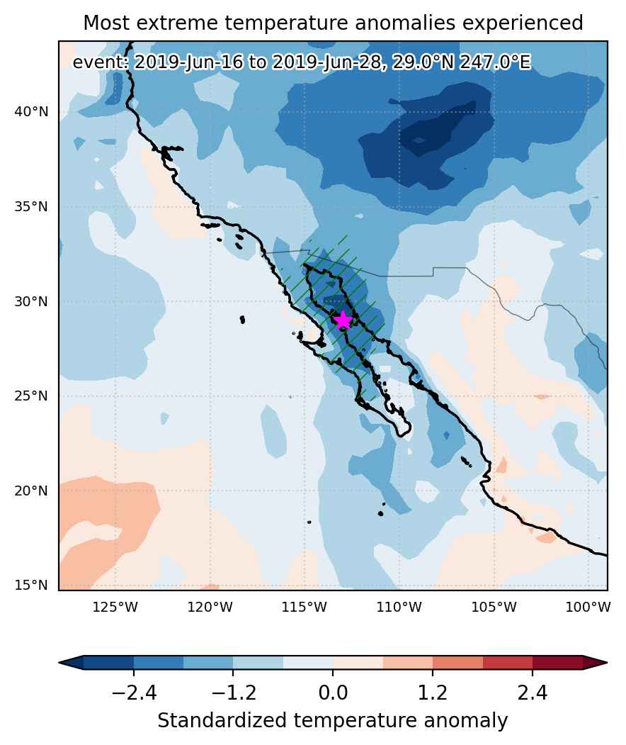
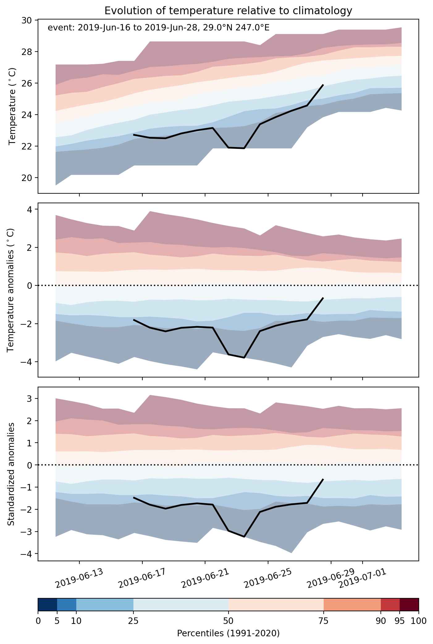
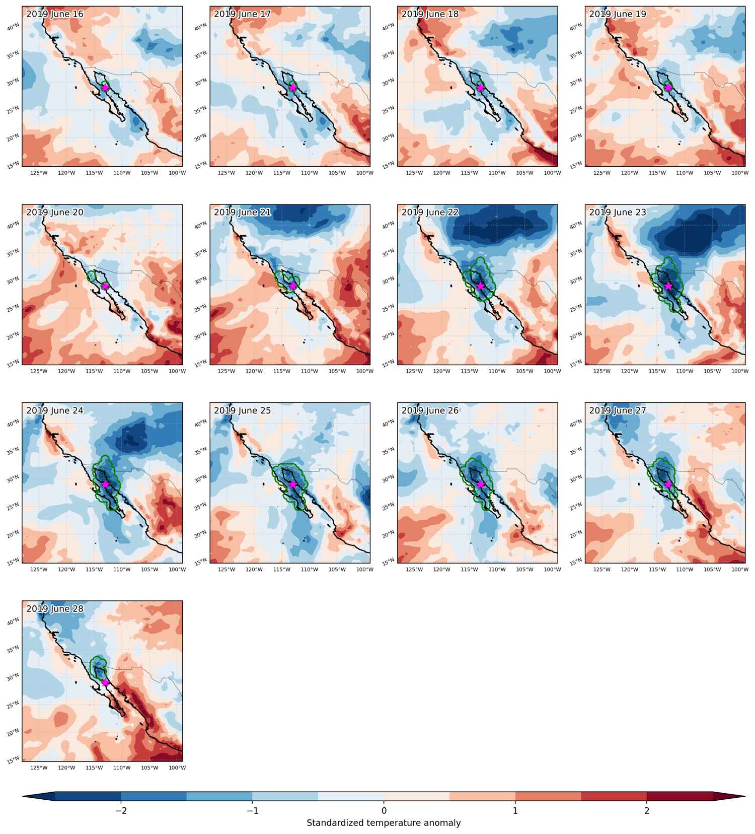
Cold spell occuring from June 16 2019 to June 28 2019 at 29.0°N 247.0°E

Download data: JSON

Event type: Cold spell

Countries affected (identified with ArcGIS Online; provided only for geographical reference):

  • Mexico
  • United States

Duration: 13 days

Time span: June 16 2019 to June 28 2019

Statistics over entire affected area:

  • Mean temperature anomaly: -3.3 °C
  • Mean temperature: 25.3 °C
  • Minimum temperature anomaly: -7.9 °C
  • Minimum temperature: 16.6 °C

Event center: 29.0°N 247.0°E

Area affected: 252324 km$^2$


Fig. 1: Map of most extreme temperature anomalies (standardized) experienced during the event. The purple star indicates the center of the extreme event. Green hatching illustrates all areas under the effect of extremes at some time during the event.


Fig. 2: Evolution of temperature at the center of the event. The climatological percentile distribution is illustrated with color shadings.


Fig. 3: Maps illustrating the evolution of standardized temperature anomalies during the event.

Event ID: Cold_spell_2019-Jun-16_to_2019-Jun-28_247.0_29.0