Heat wave occuring from April 01 2018 to August 05 2018 at 41.5°N 38.5°E

Download data: JSON

Event type: Heat wave

Countries affected (identified with ArcGIS Online; provided only for geographical reference):

  • Afghanistan
  • Albania
  • Algeria
  • Armenia
  • Austria
  • Azerbaijan
  • Bahrain
  • Belarus
  • Belgium
  • Benin
  • Bosnia and Herzegovina
  • Bulgaria
  • Burkina Faso
  • Central African Republic
  • Chad
  • China
  • Congo
  • Congo DRC
  • Croatia
  • Cyprus
  • Czech Republic
  • Côte d’Ivoire
  • Denmark
  • Djibouti
  • Egypt
  • Eritrea
  • Estonia
  • Ethiopia
  • Faroe Islands
  • Finland
  • France
  • Georgia
  • Germany
  • Ghana
  • Greece
  • Guinea
  • Hungary
  • India
  • Iran
  • Iraq
  • Israel
  • Italy
  • Jordan
  • Kazakhstan
  • Kuwait
  • Kyrgyzstan
  • Latvia
  • Lebanon
  • Libya
  • Lithuania
  • Luxembourg
  • Mali
  • Mauritania
  • Moldova
  • Montenegro
  • Nepal
  • Netherlands
  • Niger
  • Nigeria
  • North Macedonia
  • Norway
  • Oman
  • Pakistan
  • Palestinian Territory
  • Poland
  • Portugal
  • Qatar
  • Romania
  • Russian Federation
  • Saudi Arabia
  • Senegal
  • Serbia
  • Slovakia
  • Slovenia
  • Somalia
  • South Sudan
  • Spain
  • Sudan
  • Sweden
  • Switzerland
  • Syria
  • Tajikistan
  • Togo
  • Tunisia
  • Turkiye
  • Turkmenistan
  • Ukraine
  • United Arab Emirates
  • United Kingdom
  • Uzbekistan
  • Yemen

Duration: 127 days

Time span: April 01 2018 to August 05 2018

Statistics over entire affected area:

  • Mean temperature anomaly: 4.3 °C
  • Mean temperature: 26.4 °C
  • Maximum temperature anomaly: 14.2 °C
  • Maximum temperature: 43.7 °C

Event center: 41.5°N 38.5°E

Area affected: 32890949 km$^2$
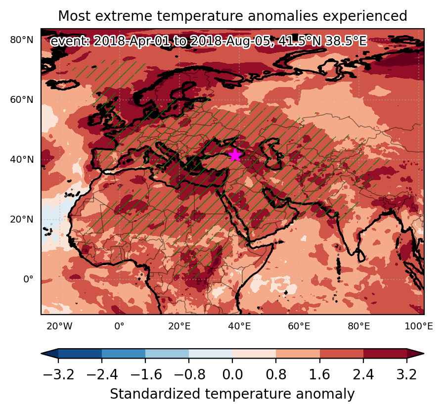

Fig. 1: Map of most extreme temperature anomalies (standardized) experienced during the event. The purple star indicates the center of the extreme event. Green hatching illustrates all areas under the effect of extremes at some time during the event.
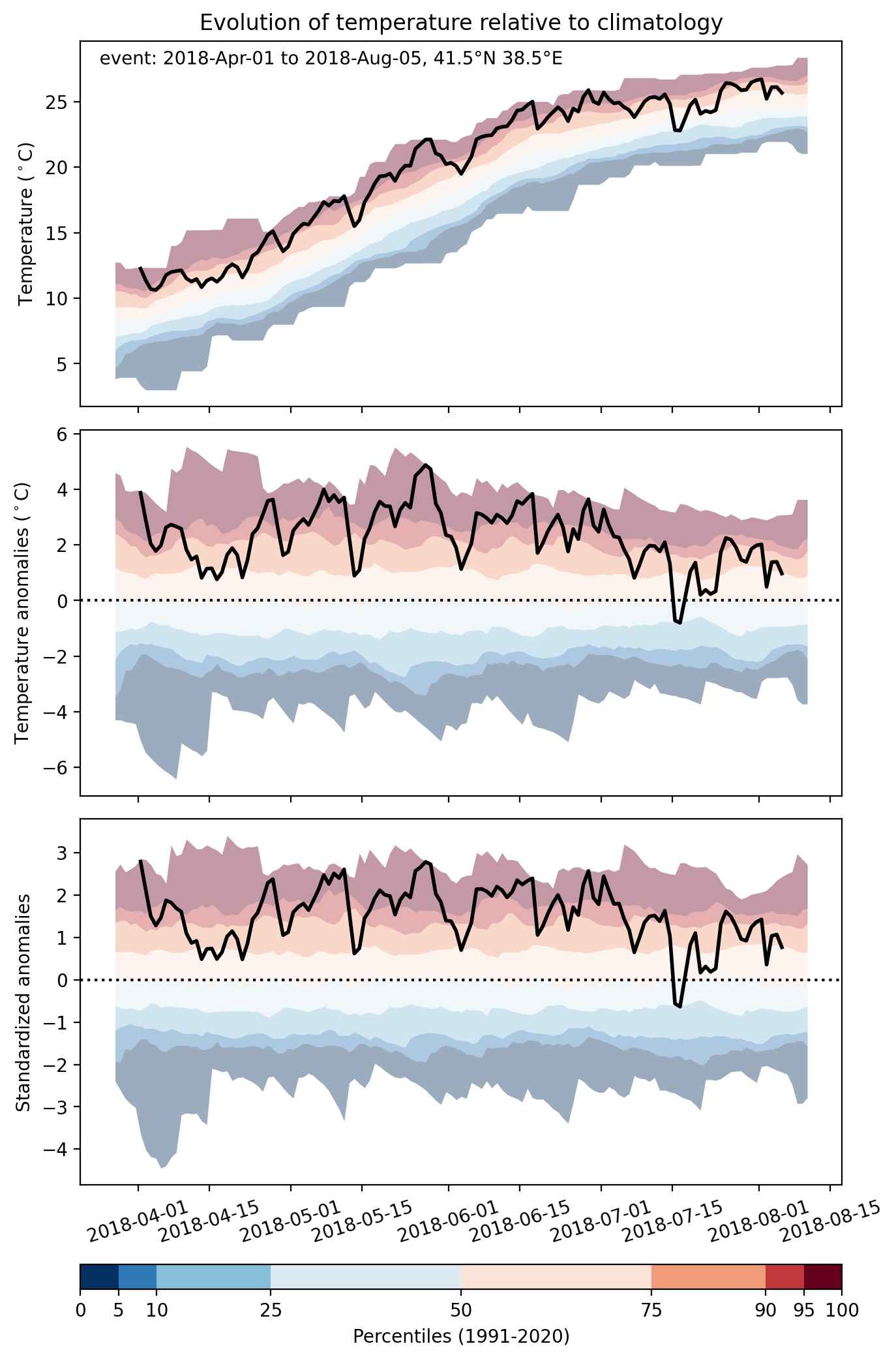


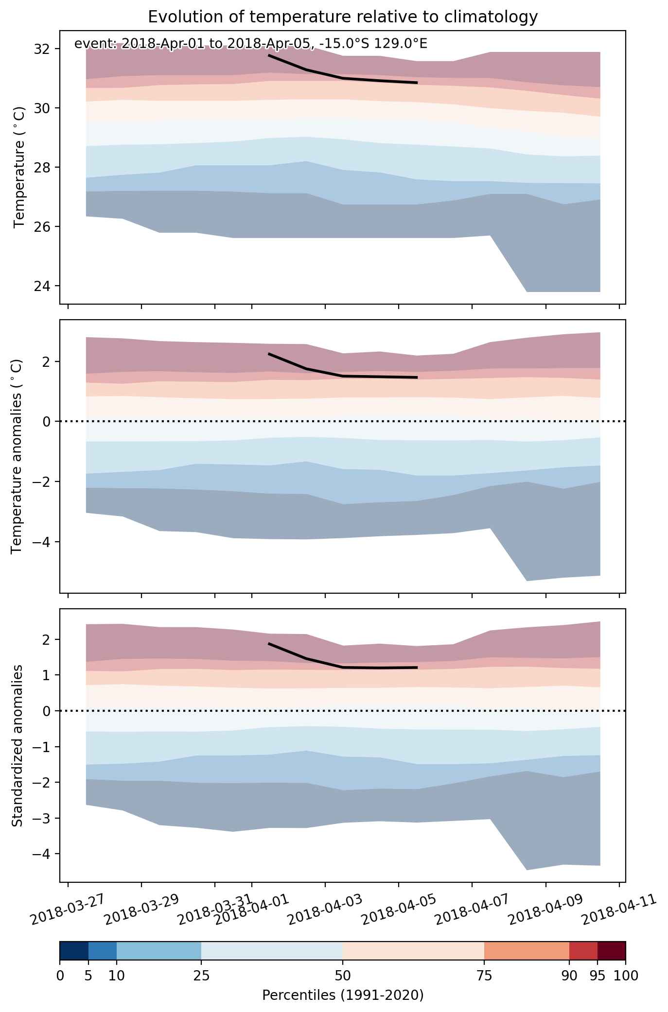
Fig. 2: Evolution of temperature at the center of the event. The climatological percentile distribution is illustrated with color shadings.
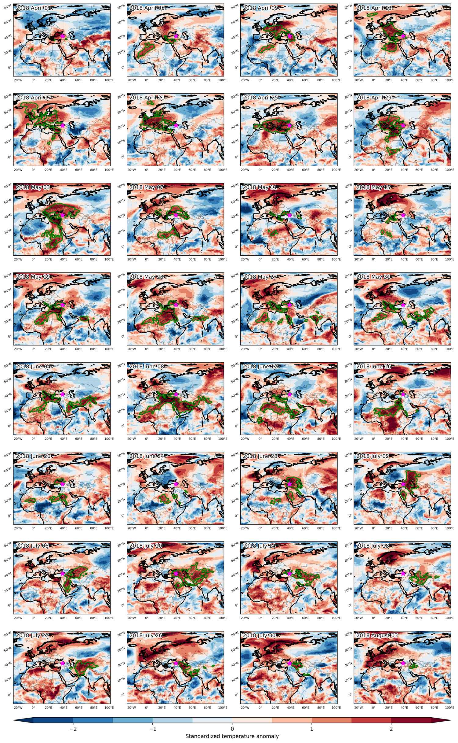


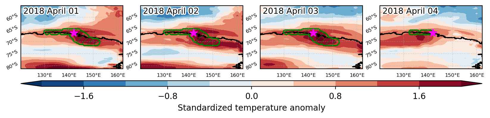
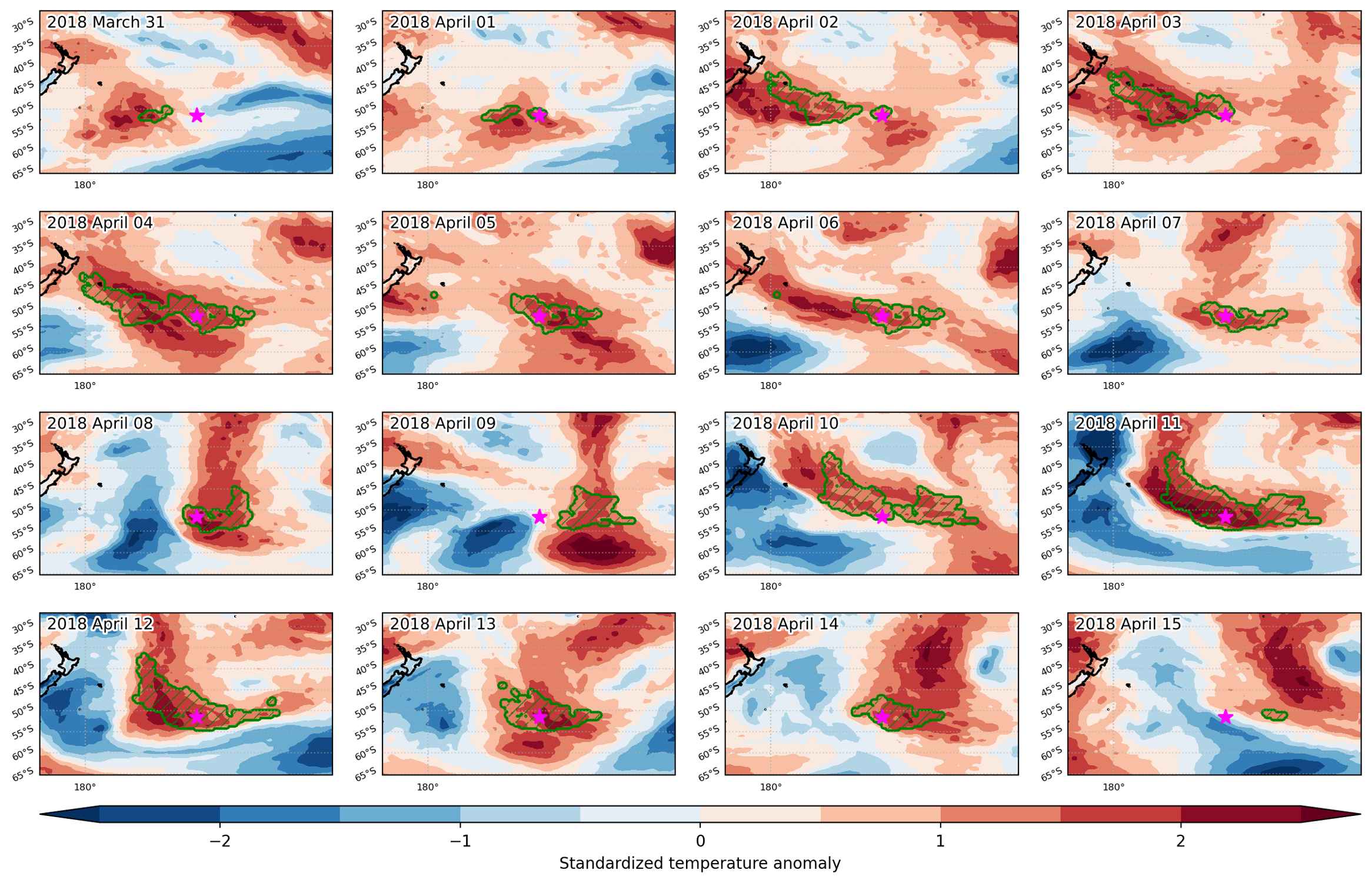
Fig. 3: Maps illustrating the evolution of standardized temperature anomalies during the event.

Event ID: Heat_wave_2018-Apr-01_to_2018-Aug-05_38.5_41.5
Heat wave occuring from April 01 2018 to April 05 2018 at -15.0°S 129.0°E

Download data: JSON

Event type: Heat wave

Countries affected (identified with ArcGIS Online; provided only for geographical reference):

  • Australia

Duration: 5 days

Time span: April 01 2018 to April 05 2018

Statistics over entire affected area:

  • Mean temperature anomaly: 1.5 °C
  • Mean temperature: 30.4 °C
  • Maximum temperature anomaly: 2.8 °C
  • Maximum temperature: 31.8 °C

Event center: -15.0°S 129.0°E

Area affected: 99170 km$^2$


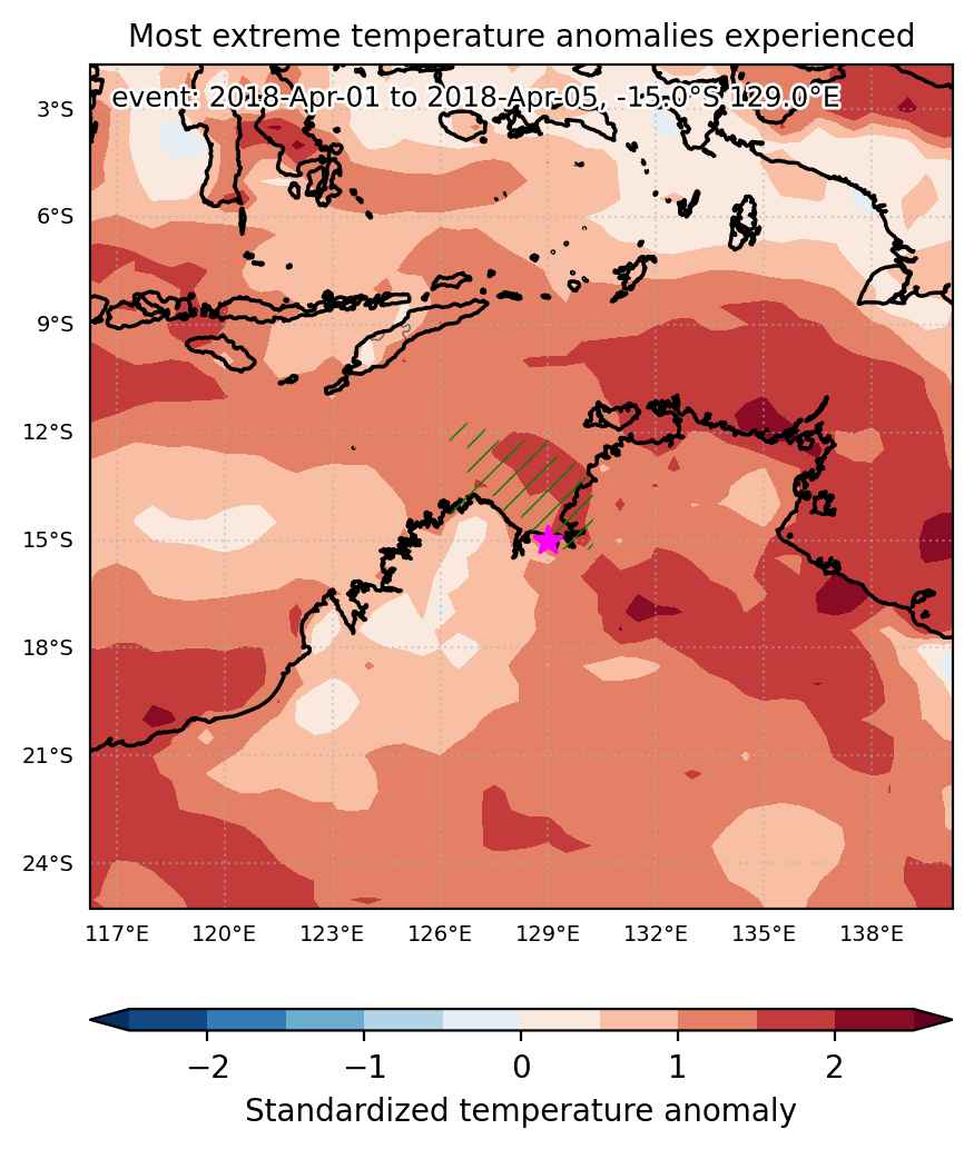
Fig. 1: Map of most extreme temperature anomalies (standardized) experienced during the event. The purple star indicates the center of the extreme event. Green hatching illustrates all areas under the effect of extremes at some time during the event.


Fig. 2: Evolution of temperature at the center of the event. The climatological percentile distribution is illustrated with color shadings.


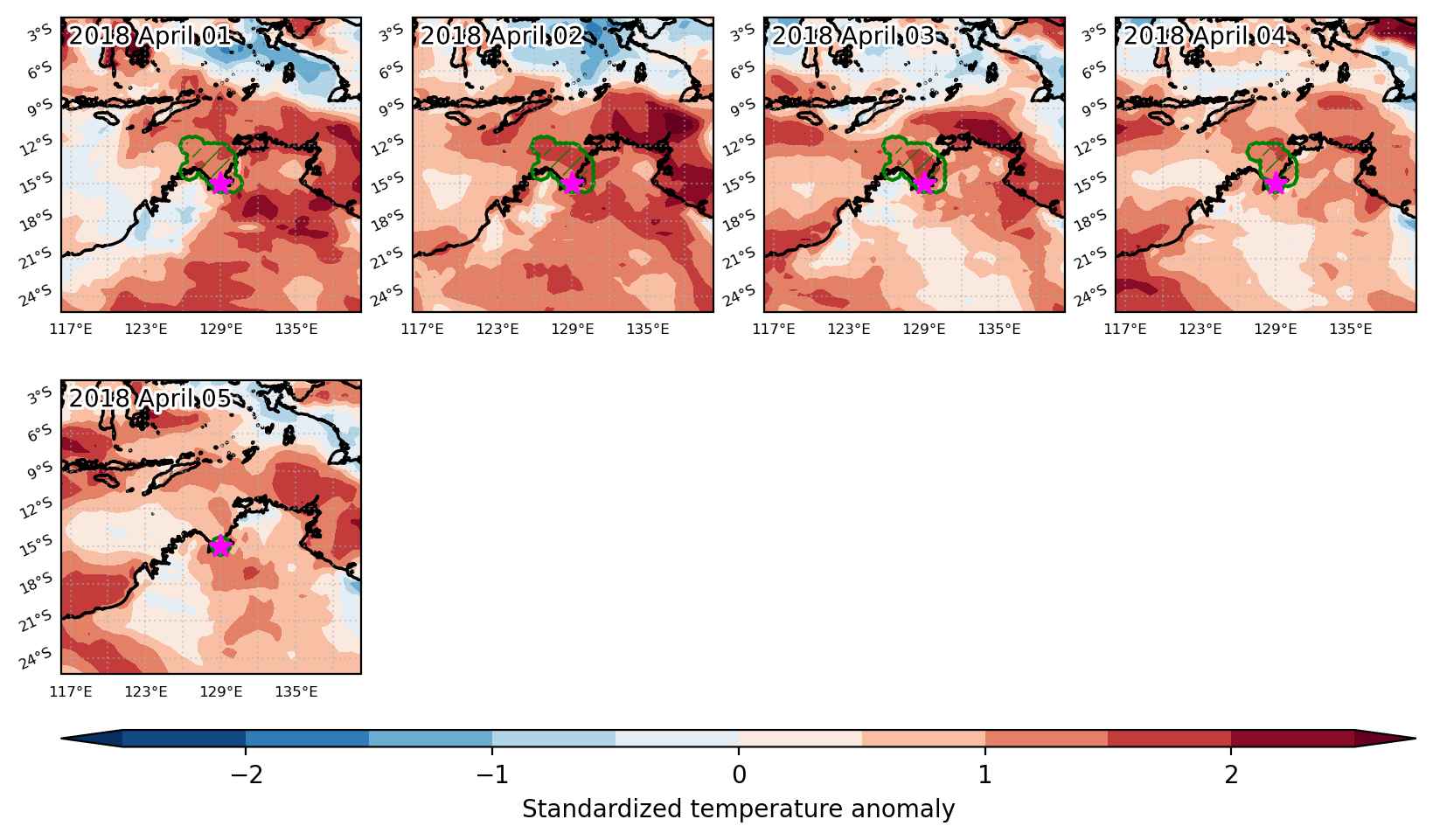
Fig. 3: Maps illustrating the evolution of standardized temperature anomalies during the event.

Event ID: Heat_wave_2018-Apr-01_to_2018-Apr-05_129.0_-15.0

Heat wave occuring from April 01 2018 to April 04 2018 at -66.5°S 142.0°E

Download data: JSON

Event type: Heat wave

Countries affected (identified with ArcGIS Online; provided only for geographical reference):

  • Antarctica

Duration: 4 days

Time span: April 01 2018 to April 04 2018

Statistics over entire affected area:

  • Mean temperature anomaly: 8.2 °C
  • Mean temperature: -13.5 °C
  • Maximum temperature anomaly: 12.0 °C
  • Maximum temperature: -2.4 °C

Event center: -66.5°S 142.0°E

Area affected: 225142 km$^2$


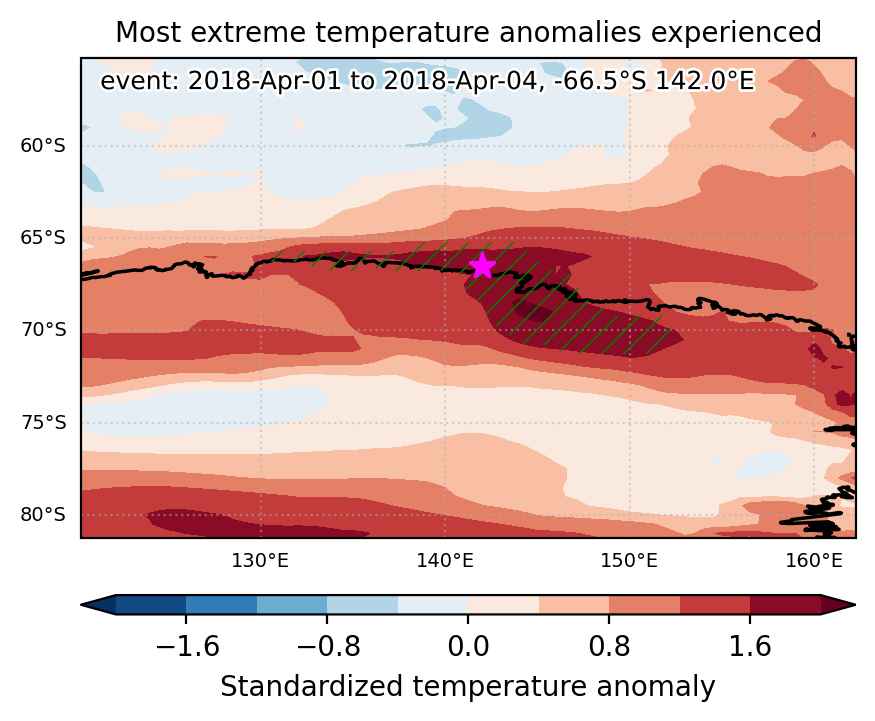
Fig. 1: Map of most extreme temperature anomalies (standardized) experienced during the event. The purple star indicates the center of the extreme event. Green hatching illustrates all areas under the effect of extremes at some time during the event.


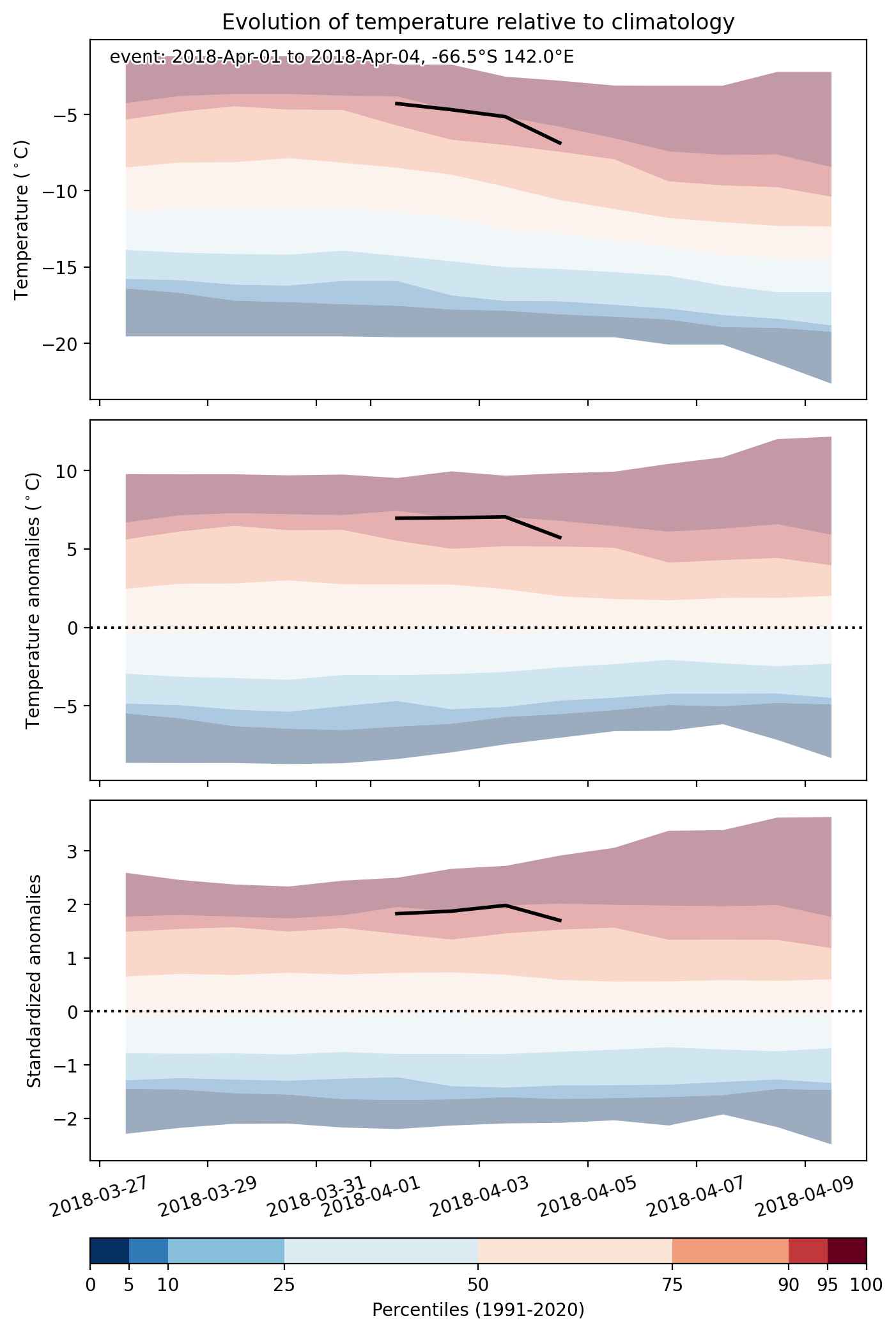
Fig. 2: Evolution of temperature at the center of the event. The climatological percentile distribution is illustrated with color shadings.


Fig. 3: Maps illustrating the evolution of standardized temperature anomalies during the event.

Event ID: Heat_wave_2018-Apr-01_to_2018-Apr-04_142.0_-66.5

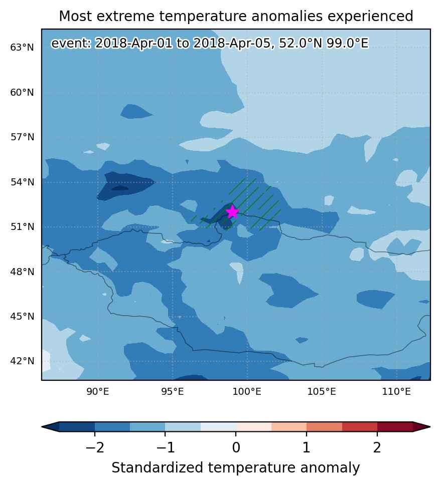
Cold spell occuring from April 01 2018 to April 05 2018 at 52.0°N 99.0°E

Download data: JSON

Event type: Cold spell

Countries affected (identified with ArcGIS Online; provided only for geographical reference):

  • Mongolia
  • Russian Federation

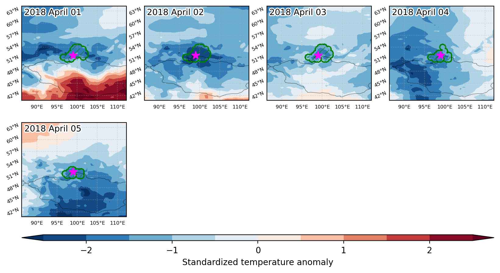
Duration: 5 days

Time span: April 01 2018 to April 05 2018

Statistics over entire affected area:

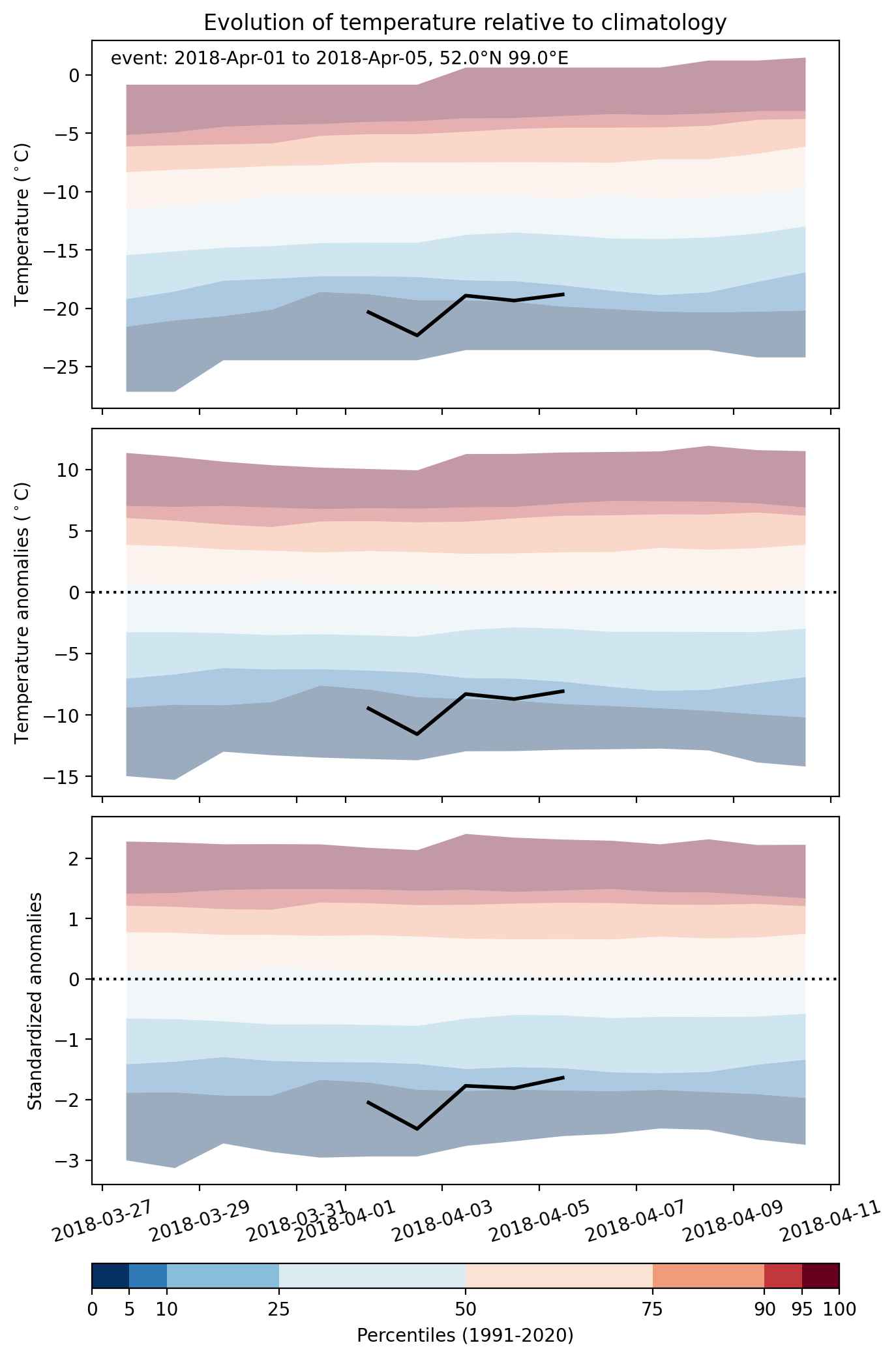
  • Mean temperature anomaly: -8.6 °C
  • Mean temperature: -15.9 °C
  • Minimum temperature anomaly: -13.1 °C
  • Minimum temperature: -23.6 °C

Event center: 52.0°N 99.0°E

Area affected: 83128 km$^2$


Fig. 1: Map of most extreme temperature anomalies (standardized) experienced during the event. The purple star indicates the center of the extreme event. Green hatching illustrates all areas under the effect of extremes at some time during the event.


Fig. 2: Evolution of temperature at the center of the event. The climatological percentile distribution is illustrated with color shadings.


Fig. 3: Maps illustrating the evolution of standardized temperature anomalies during the event.

Event ID: Cold_spell_2018-Apr-01_to_2018-Apr-05_99.0_52.0

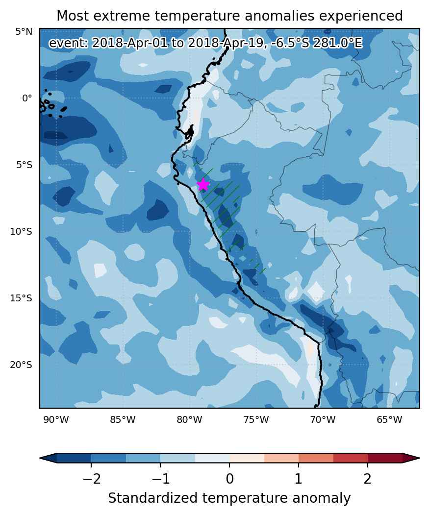
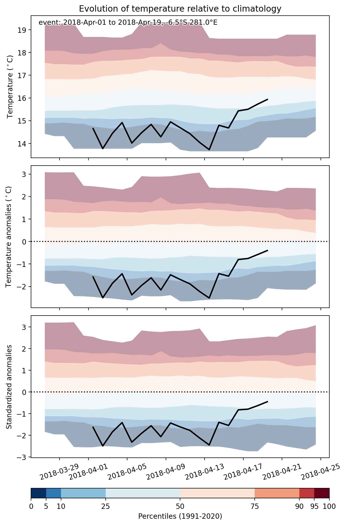
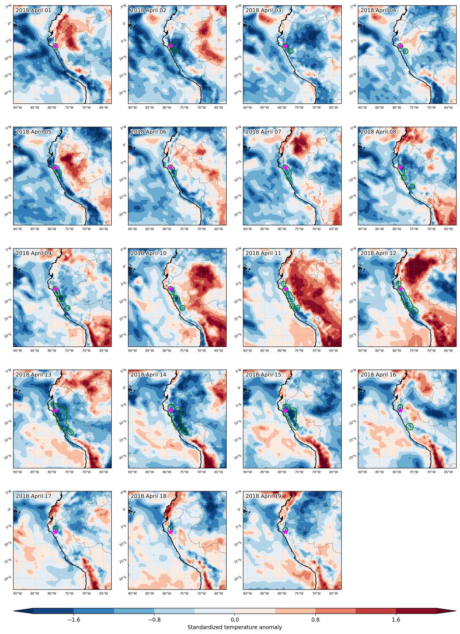
Cold spell occuring from April 01 2018 to April 19 2018 at -6.5°S 281.0°E

Download data: JSON

Event type: Cold spell

Countries affected (identified with ArcGIS Online; provided only for geographical reference):

  • Peru

Duration: 19 days

Time span: April 01 2018 to April 19 2018

Statistics over entire affected area:

  • Mean temperature anomaly: -1.7 °C
  • Mean temperature: 11.0 °C
  • Minimum temperature anomaly: -3.0 °C
  • Minimum temperature: 0.4 °C

Event center: -6.5°S 281.0°E

Area affected: 146666 km$^2$


Fig. 1: Map of most extreme temperature anomalies (standardized) experienced during the event. The purple star indicates the center of the extreme event. Green hatching illustrates all areas under the effect of extremes at some time during the event.


Fig. 2: Evolution of temperature at the center of the event. The climatological percentile distribution is illustrated with color shadings.


Fig. 3: Maps illustrating the evolution of standardized temperature anomalies during the event.

Event ID: Cold_spell_2018-Apr-01_to_2018-Apr-19_281.0_-6.5

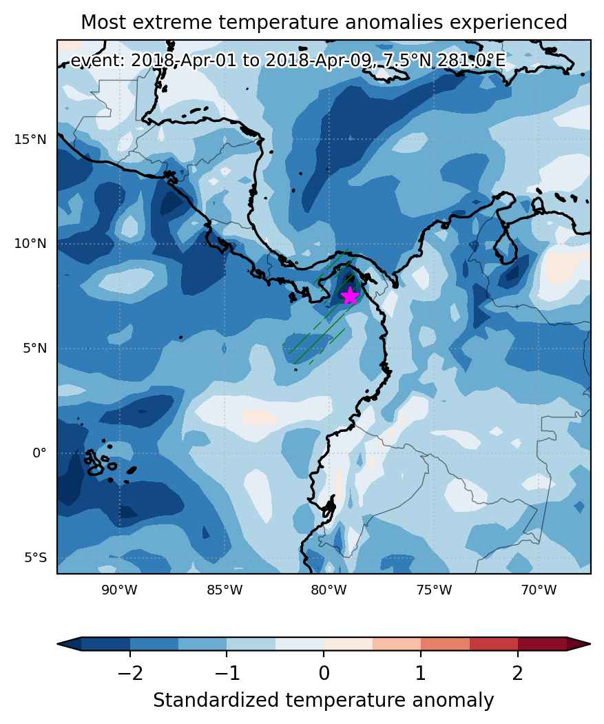
Cold spell occuring from April 01 2018 to April 09 2018 at 7.5°N 281.0°E

Download data: JSON

Event type: Cold spell

Countries affected (identified with ArcGIS Online; provided only for geographical reference):

  • Panama

Duration: 9 days

Time span: April 01 2018 to April 09 2018

Statistics over entire affected area:

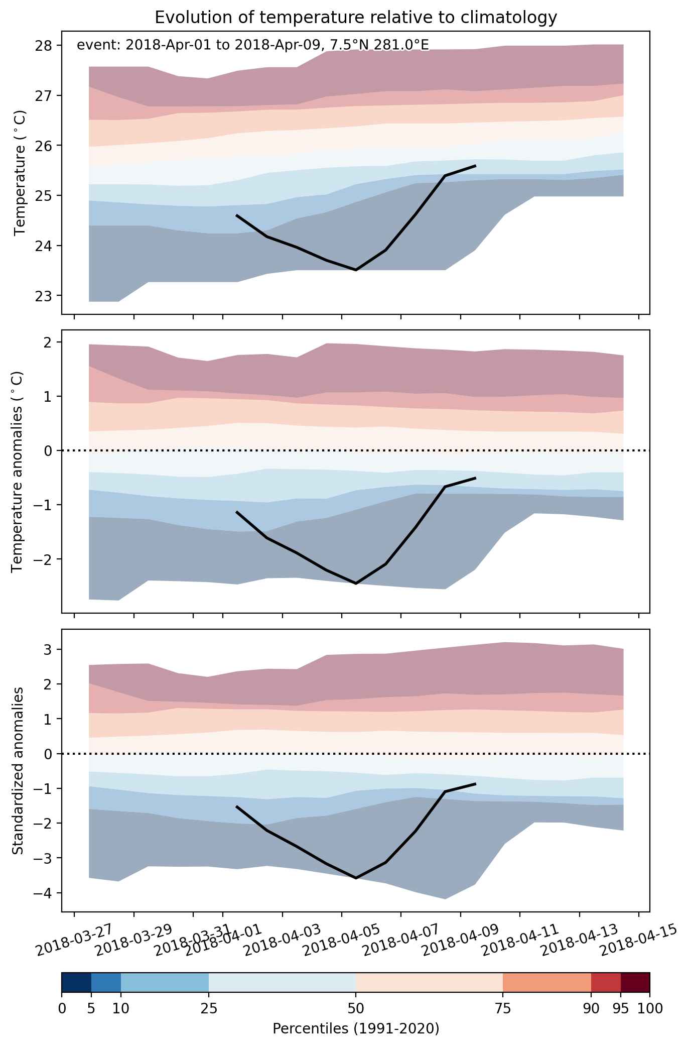
  • Mean temperature anomaly: -1.2 °C
  • Mean temperature: 24.9 °C
  • Minimum temperature anomaly: -2.5 °C
  • Minimum temperature: 23.5 °C

Event center: 7.5°N 281.0°E

Area affected: 104299 km$^2$


Fig. 1: Map of most extreme temperature anomalies (standardized) experienced during the event. The purple star indicates the center of the extreme event. Green hatching illustrates all areas under the effect of extremes at some time during the event.


Fig. 2: Evolution of temperature at the center of the event. The climatological percentile distribution is illustrated with color shadings.


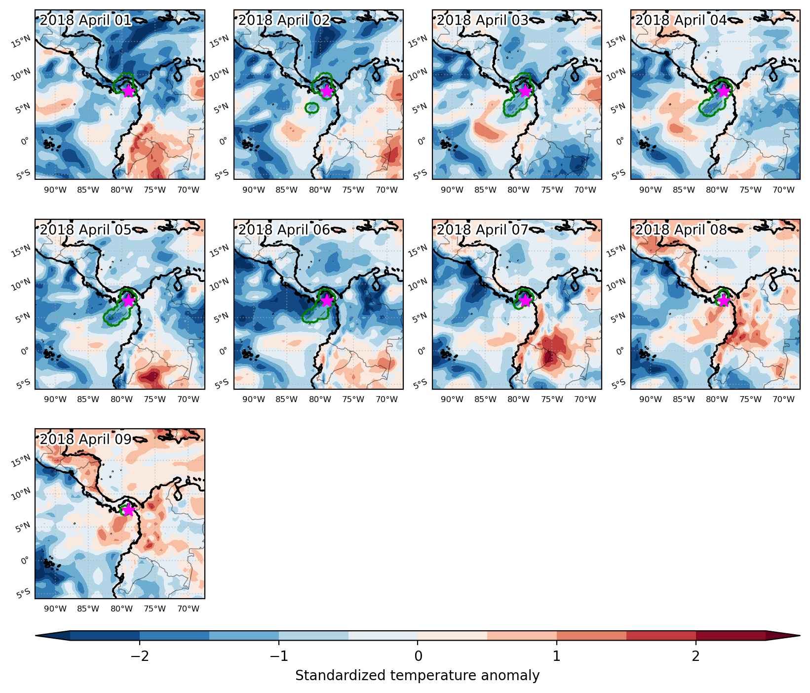
Fig. 3: Maps illustrating the evolution of standardized temperature anomalies during the event.

Event ID: Cold_spell_2018-Apr-01_to_2018-Apr-09_281.0_7.5

Heat wave occuring from March 31 2018 to April 15 2018 at -51.5°S 206.5°E

Download data: JSON

Event type: Heat wave

Countries affected (identified with ArcGIS Online; provided only for geographical reference):

  • New Zealand

Duration: 16 days

Time span: March 31 2018 to April 15 2018

Statistics over entire affected area:

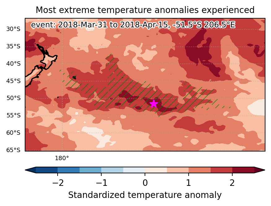
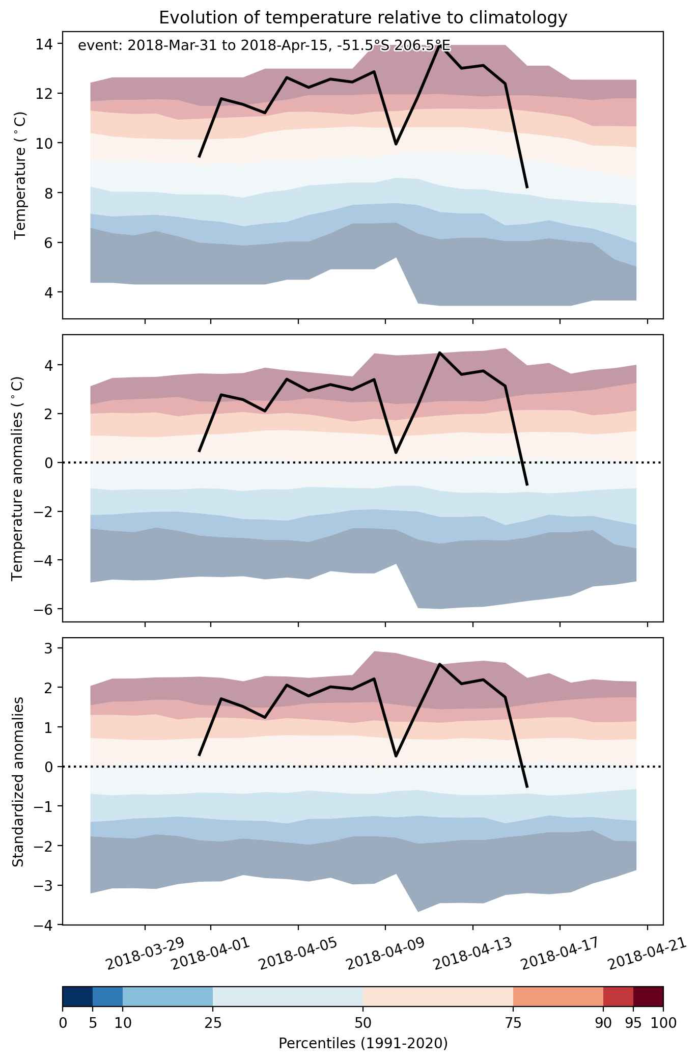
  • Mean temperature anomaly: 2.5 °C
  • Mean temperature: 12.9 °C
  • Maximum temperature anomaly: 4.5 °C
  • Maximum temperature: 19.8 °C

Event center: -51.5°S 206.5°E

Area affected: 2242714 km$^2$


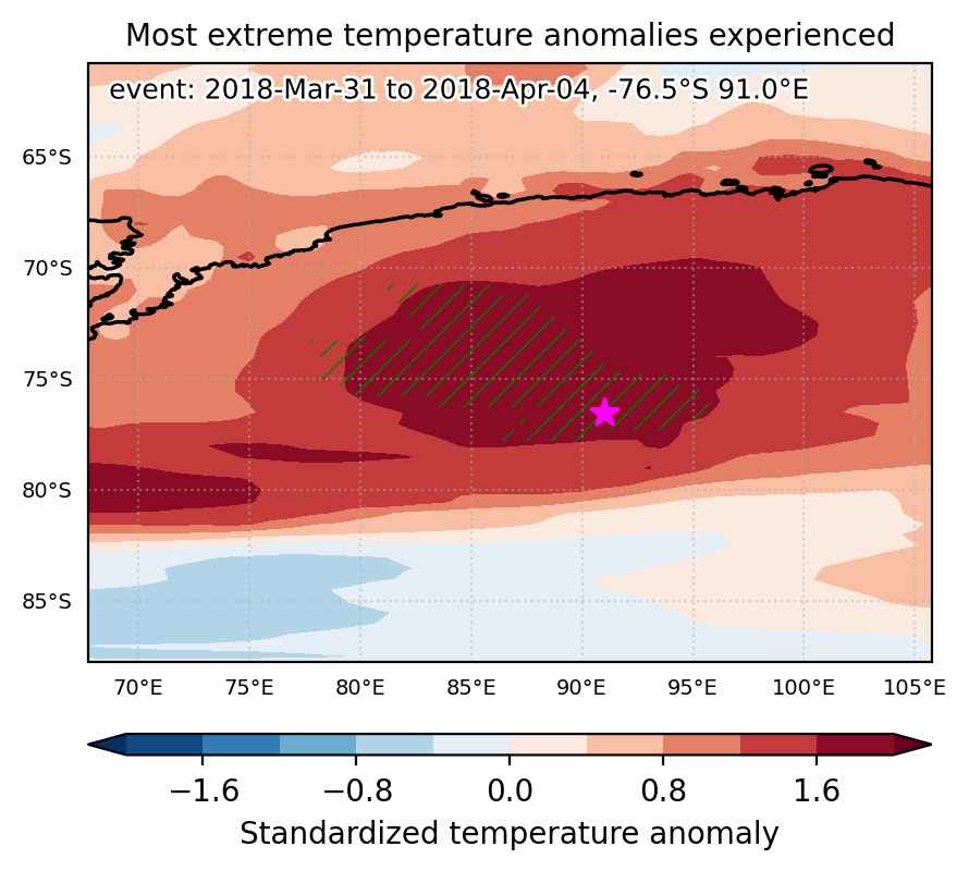
Fig. 1: Map of most extreme temperature anomalies (standardized) experienced during the event. The purple star indicates the center of the extreme event. Green hatching illustrates all areas under the effect of extremes at some time during the event.


Fig. 2: Evolution of temperature at the center of the event. The climatological percentile distribution is illustrated with color shadings.


Fig. 3: Maps illustrating the evolution of standardized temperature anomalies during the event.

Event ID: Heat_wave_2018-Mar-31_to_2018-Apr-15_206.5_-51.5

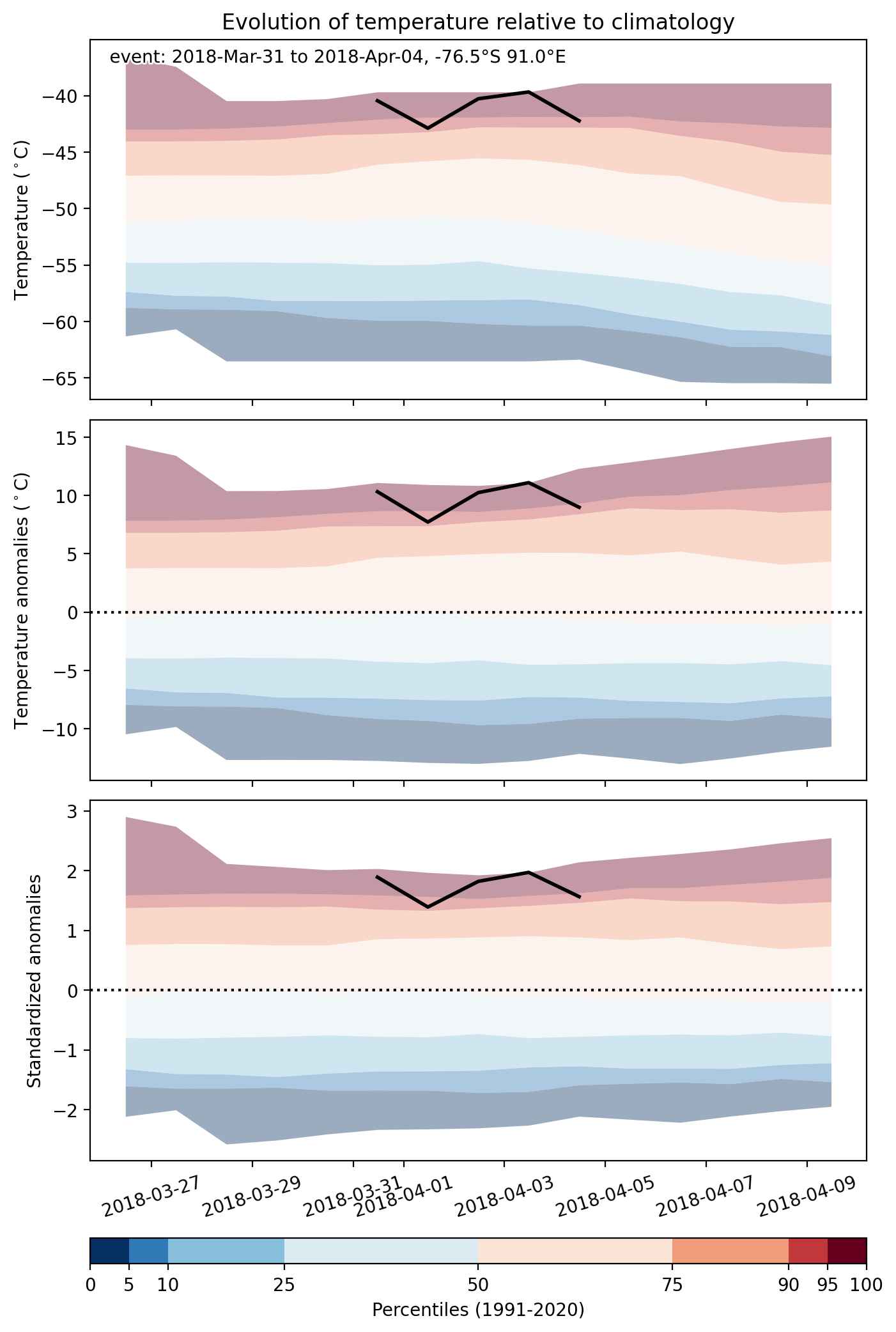
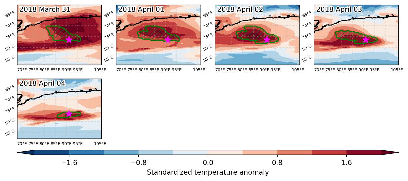
Heat wave occuring from March 31 2018 to April 04 2018 at -76.5°S 91.0°E

Download data: JSON

Event type: Heat wave

Countries affected (identified with ArcGIS Online; provided only for geographical reference):

  • Antarctica

Duration: 5 days

Time span: March 31 2018 to April 04 2018

Statistics over entire affected area:

  • Mean temperature anomaly: 9.2 °C
  • Mean temperature: -35.6 °C
  • Maximum temperature anomaly: 11.7 °C
  • Maximum temperature: -25.4 °C

Event center: -76.5°S 91.0°E

Area affected: 221240 km$^2$


Fig. 1: Map of most extreme temperature anomalies (standardized) experienced during the event. The purple star indicates the center of the extreme event. Green hatching illustrates all areas under the effect of extremes at some time during the event.


Fig. 2: Evolution of temperature at the center of the event. The climatological percentile distribution is illustrated with color shadings.


Fig. 3: Maps illustrating the evolution of standardized temperature anomalies during the event.

Event ID: Heat_wave_2018-Mar-31_to_2018-Apr-04_91.0_-76.5

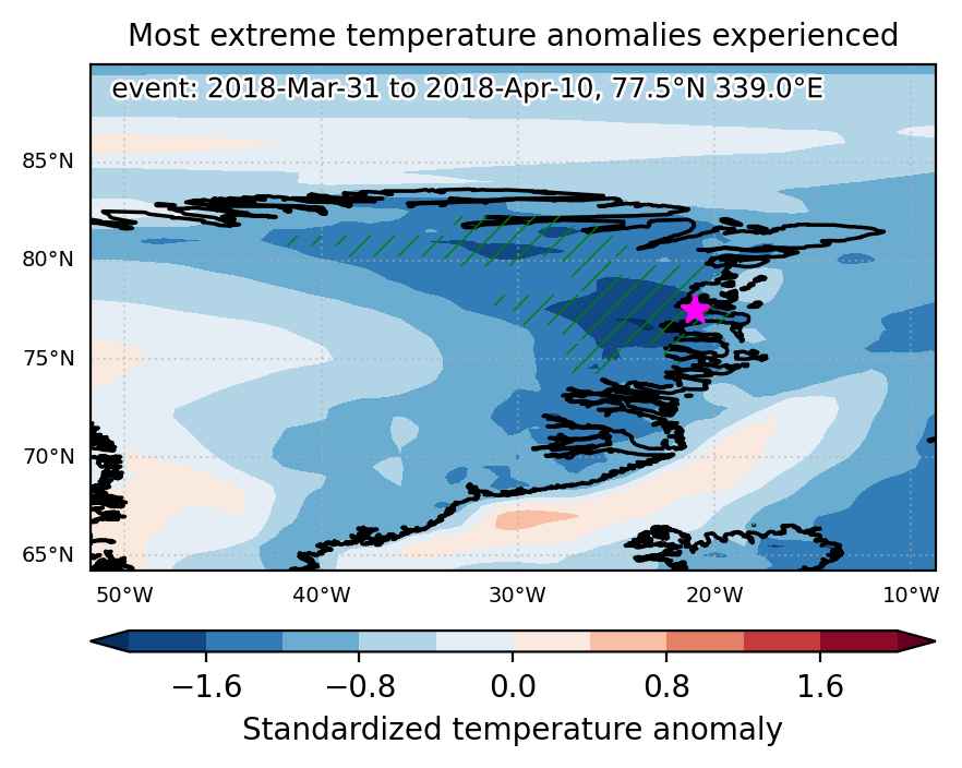
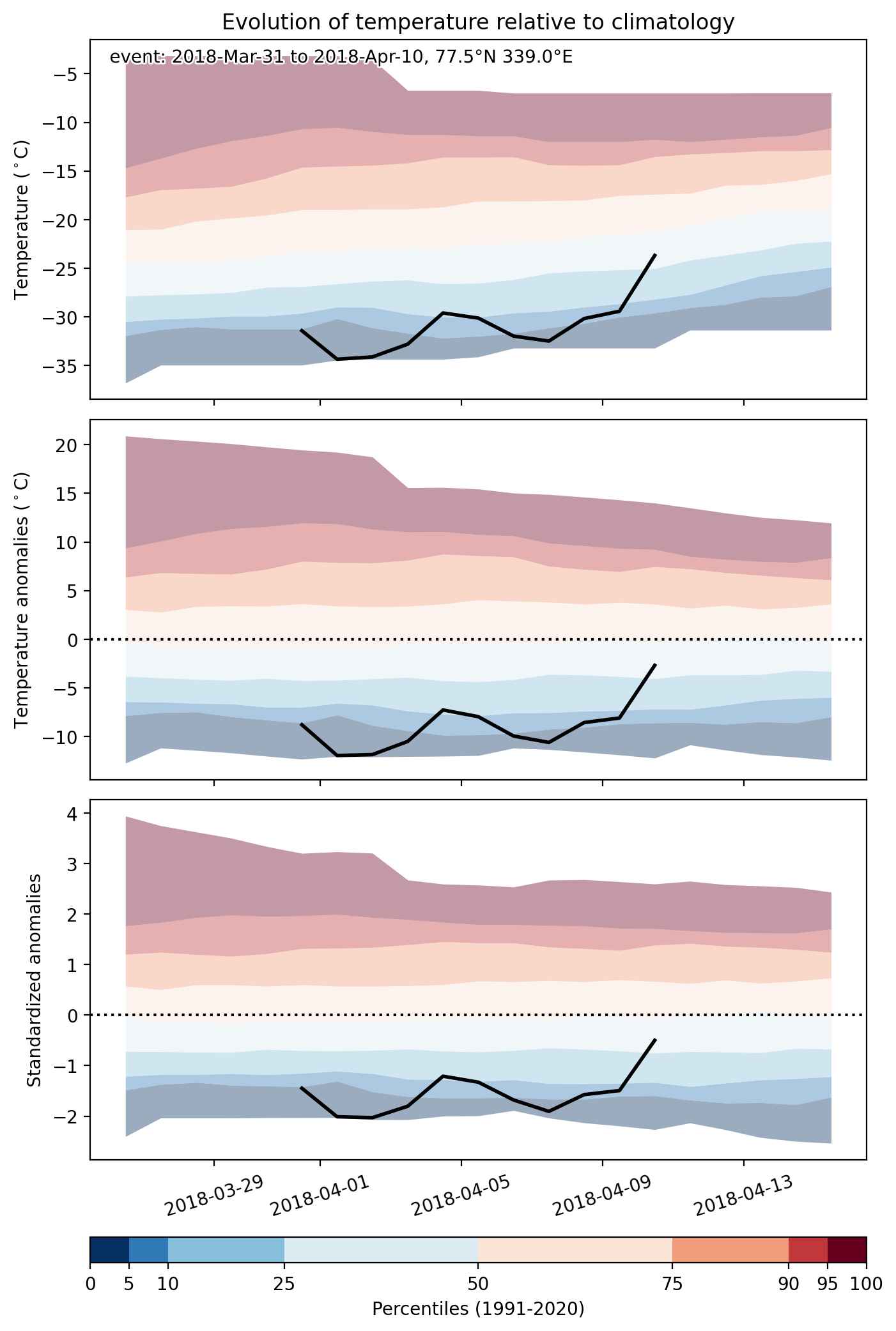
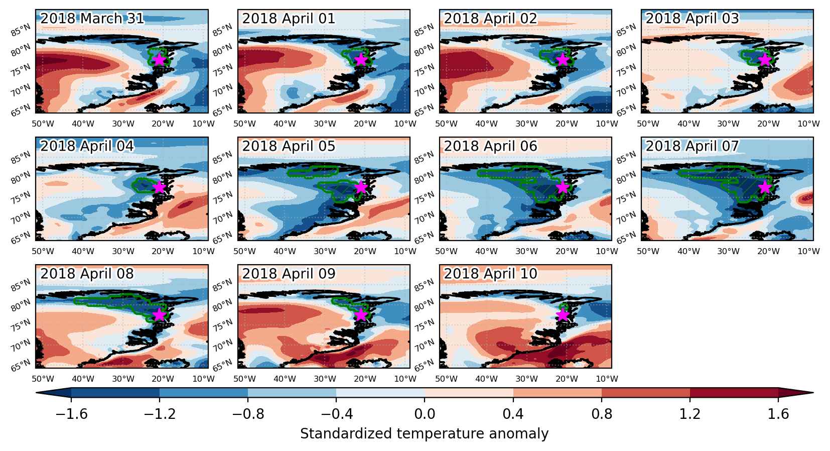
Cold spell occuring from March 31 2018 to April 10 2018 at 77.5°N 339.0°E

Download data: JSON

Event type: Cold spell

Countries affected (identified with ArcGIS Online; provided only for geographical reference):

  • Greenland

Duration: 11 days

Time span: March 31 2018 to April 10 2018

Statistics over entire affected area:

  • Mean temperature anomaly: -7.7 °C
  • Mean temperature: -33.6 °C
  • Minimum temperature anomaly: -12.5 °C
  • Minimum temperature: -43.1 °C

Event center: 77.5°N 339.0°E

Area affected: 148250 km$^2$


Fig. 1: Map of most extreme temperature anomalies (standardized) experienced during the event. The purple star indicates the center of the extreme event. Green hatching illustrates all areas under the effect of extremes at some time during the event.


Fig. 2: Evolution of temperature at the center of the event. The climatological percentile distribution is illustrated with color shadings.


Fig. 3: Maps illustrating the evolution of standardized temperature anomalies during the event.

Event ID: Cold_spell_2018-Mar-31_to_2018-Apr-10_339.0_77.5

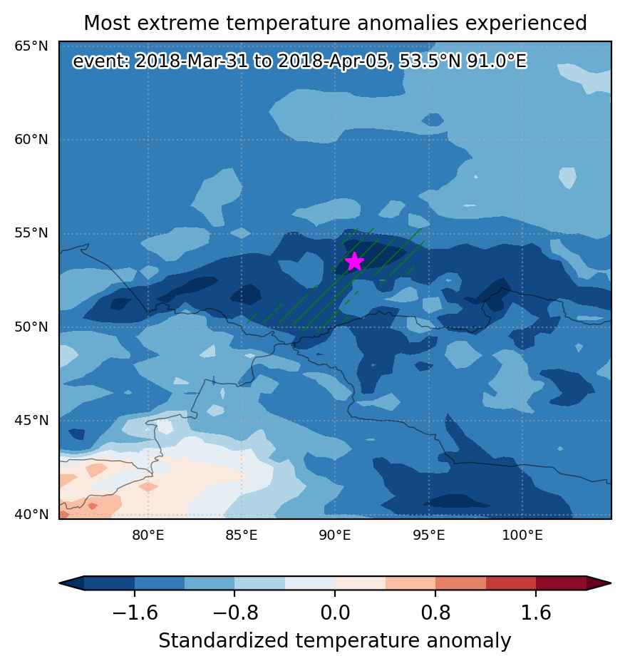
Cold spell occuring from March 31 2018 to April 05 2018 at 53.5°N 91.0°E

Download data: JSON

Event type: Cold spell

Countries affected (identified with ArcGIS Online; provided only for geographical reference):

  • Russian Federation

Duration: 6 days

Time span: March 31 2018 to April 05 2018

Statistics over entire affected area:

  • Mean temperature anomaly: -8.2 °C
  • Mean temperature: -10.7 °C
  • Minimum temperature anomaly: -12.3 °C
  • Minimum temperature: -19.8 °C

Event center: 53.5°N 91.0°E

Area affected: 142830 km$^2$


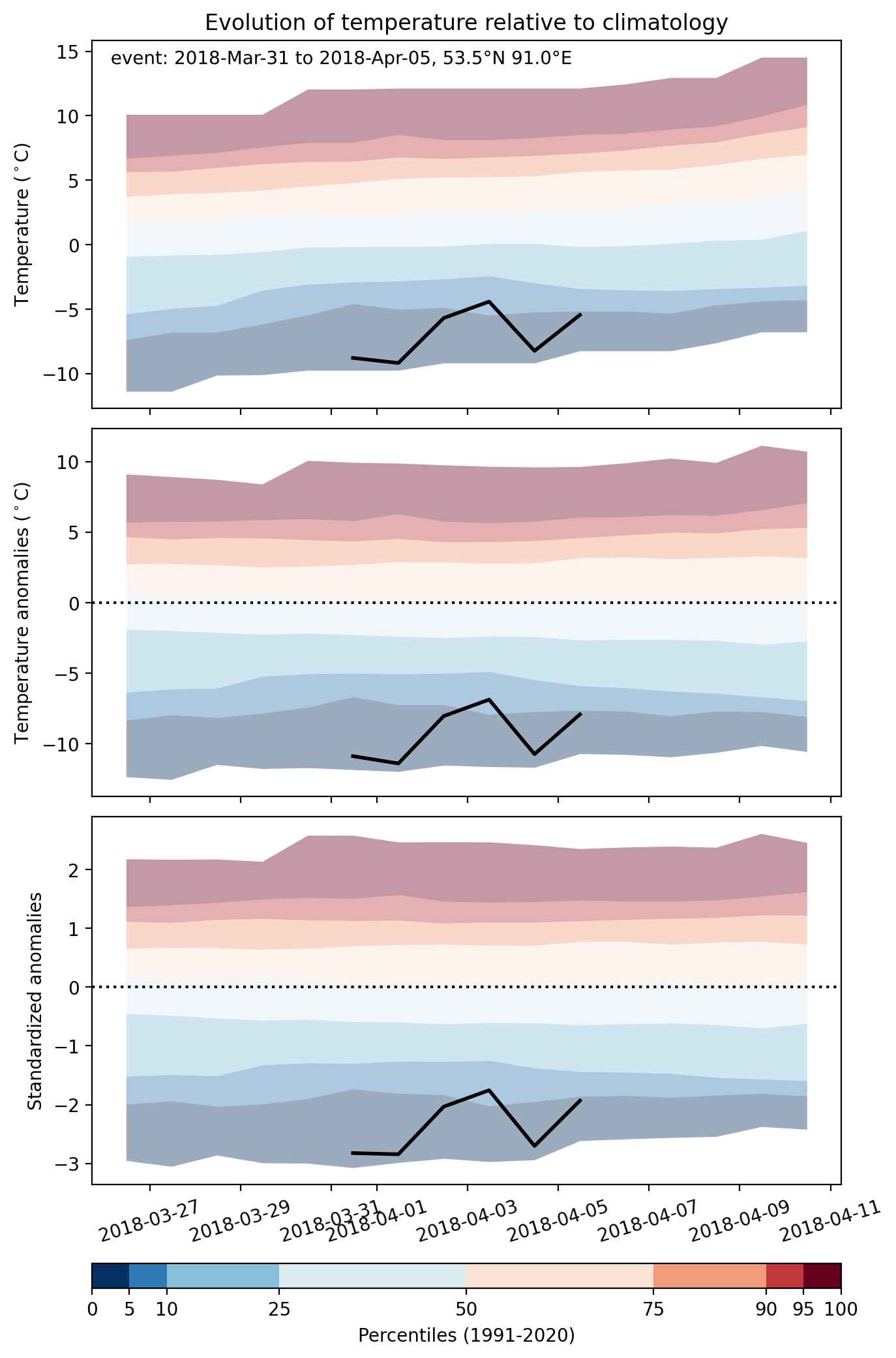
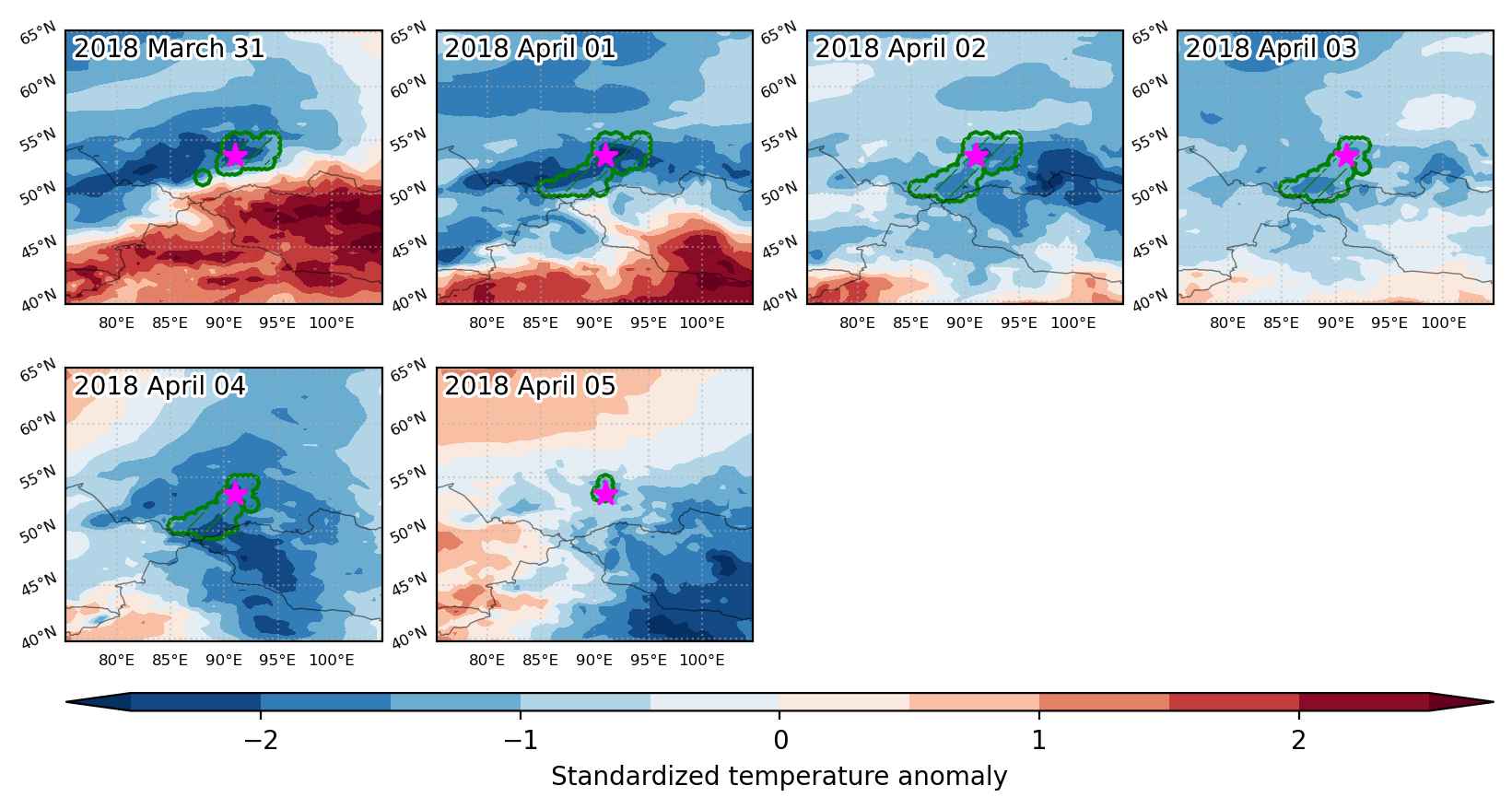
Fig. 1: Map of most extreme temperature anomalies (standardized) experienced during the event. The purple star indicates the center of the extreme event. Green hatching illustrates all areas under the effect of extremes at some time during the event.


Fig. 2: Evolution of temperature at the center of the event. The climatological percentile distribution is illustrated with color shadings.


Fig. 3: Maps illustrating the evolution of standardized temperature anomalies during the event.

Event ID: Cold_spell_2018-Mar-31_to_2018-Apr-05_91.0_53.5