Cold spell occuring from April 15 2019 to May 04 2019 at 33.5°N 45.5°E

Download data: JSON

Event type: Cold spell

Countries affected (identified with ArcGIS Online; provided only for geographical reference):

  • Afghanistan
  • Armenia
  • Azerbaijan
  • Bahrain
  • Chad
  • Cyprus
  • Egypt
  • Eritrea
  • Ethiopia
  • Georgia
  • Iran
  • Iraq
  • Israel
  • Jordan
  • Kazakhstan
  • Kuwait
  • Kyrgyzstan
  • Lebanon
  • Libya
  • Oman
  • Pakistan
  • Palestinian Territory
  • Qatar
  • Russian Federation
  • Saudi Arabia
  • Sudan
  • Syria
  • Tajikistan
  • Turkiye
  • Turkmenistan
  • United Arab Emirates
  • Uzbekistan
  • Yemen

Duration: 20 days

Time span: April 15 2019 to May 04 2019

Statistics over entire affected area:

  • Mean temperature anomaly: -6.1 °C
  • Mean temperature: 14.7 °C
  • Minimum temperature anomaly: -14.7 °C
  • Minimum temperature: -7.8 °C

Event center: 33.5°N 45.5°E

Area affected: 11644675 km$^2$
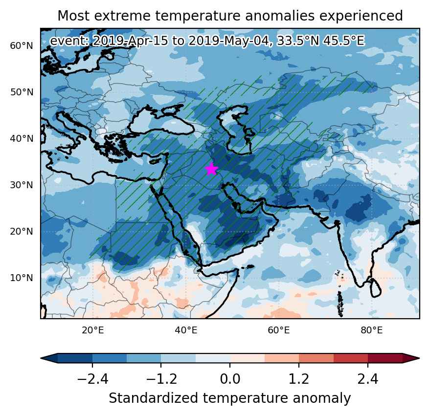

Fig. 1: Map of most extreme temperature anomalies (standardized) experienced during the event. The purple star indicates the center of the extreme event. Green hatching illustrates all areas under the effect of extremes at some time during the event.
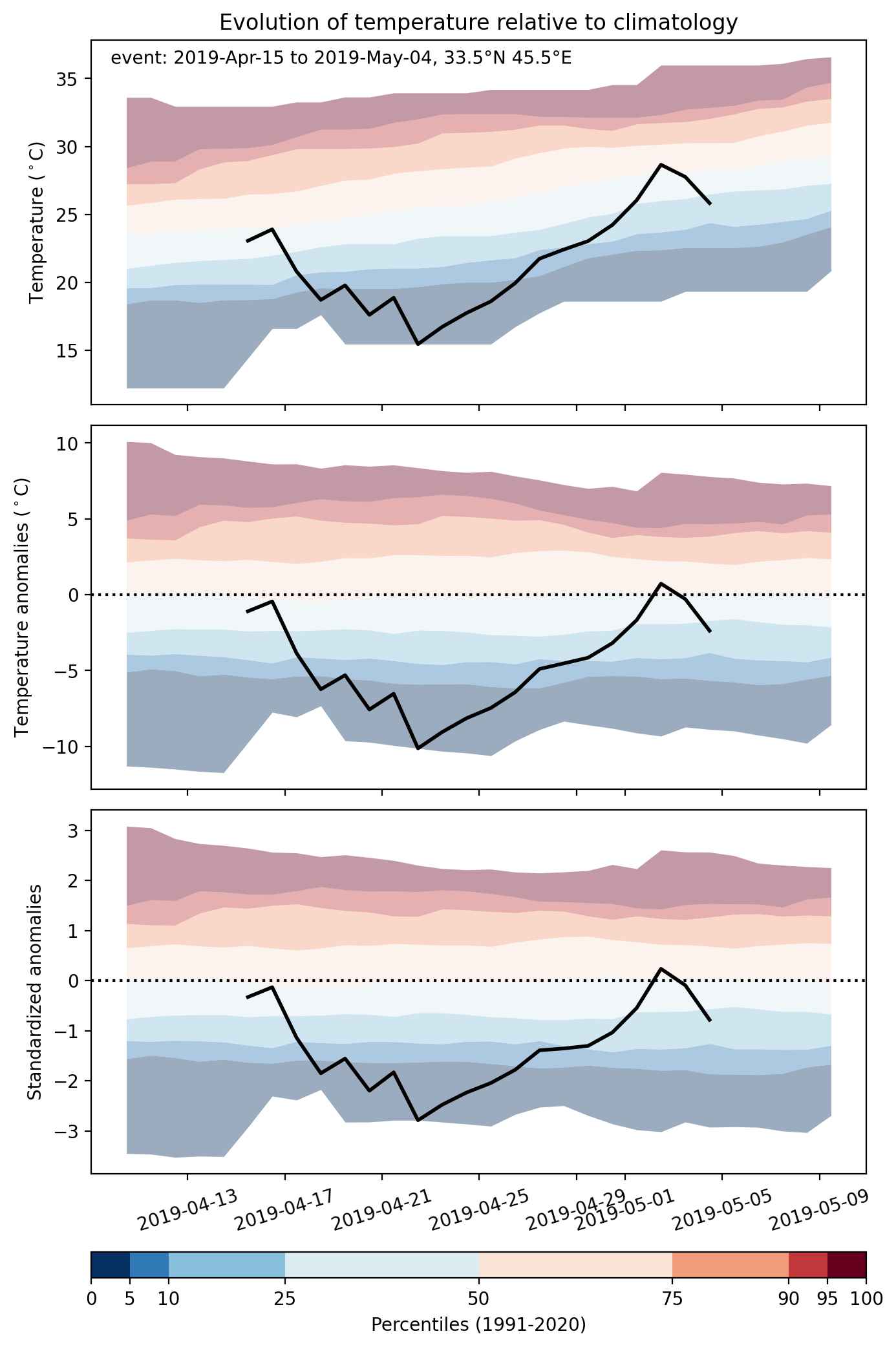


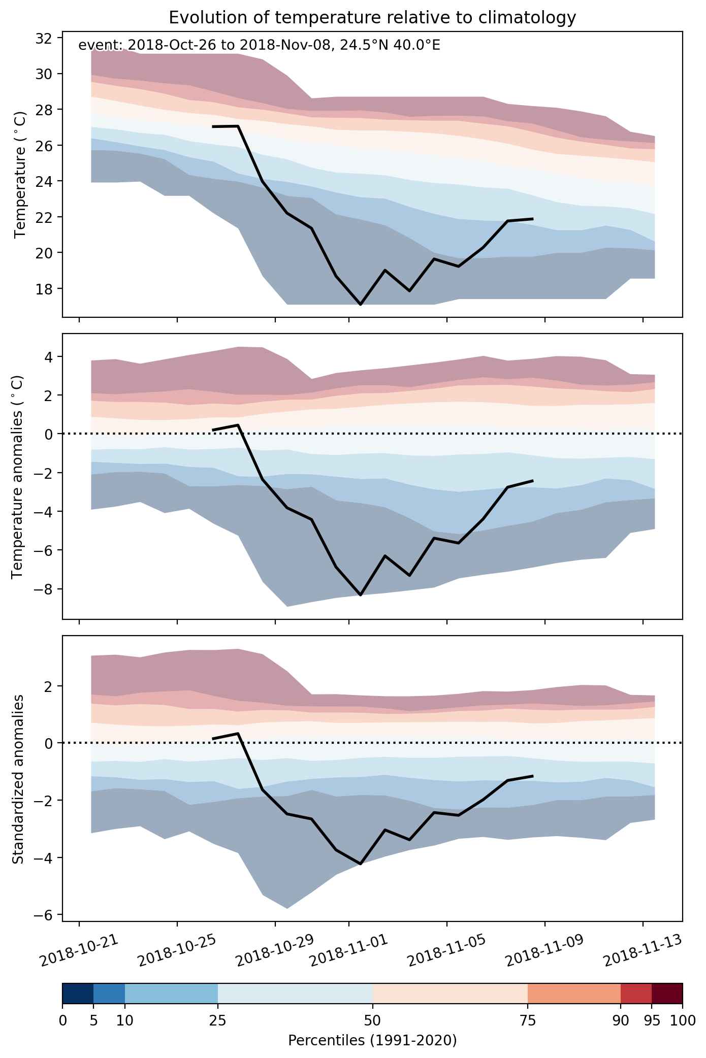
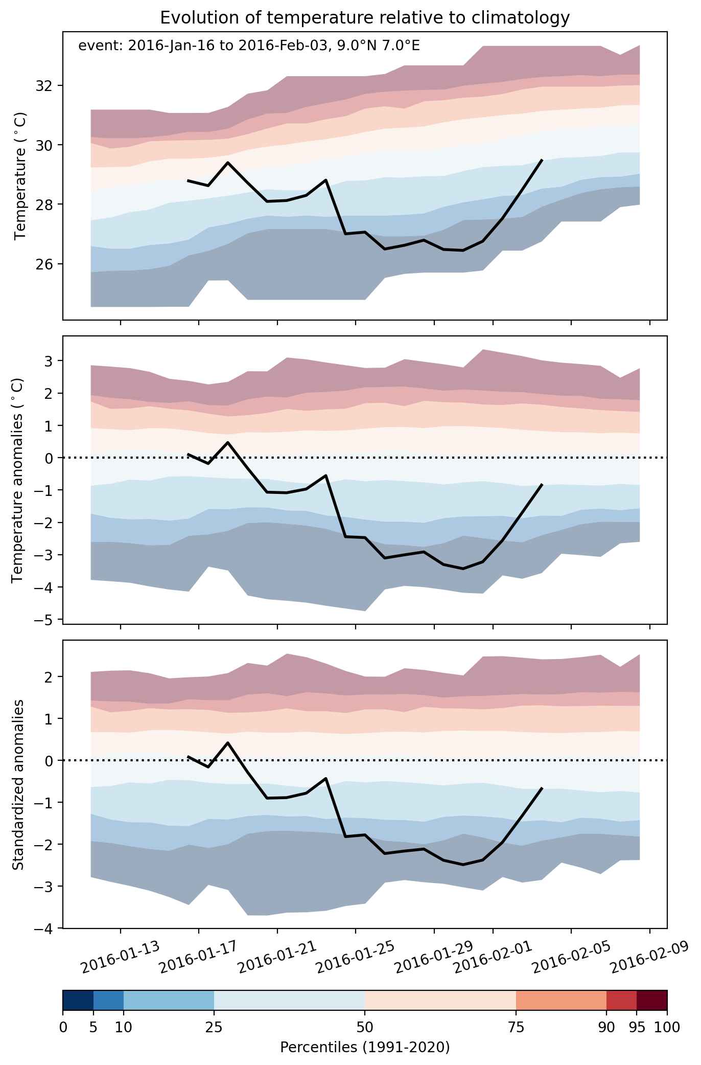
Fig. 2: Evolution of temperature at the center of the event. The climatological percentile distribution is illustrated with color shadings.
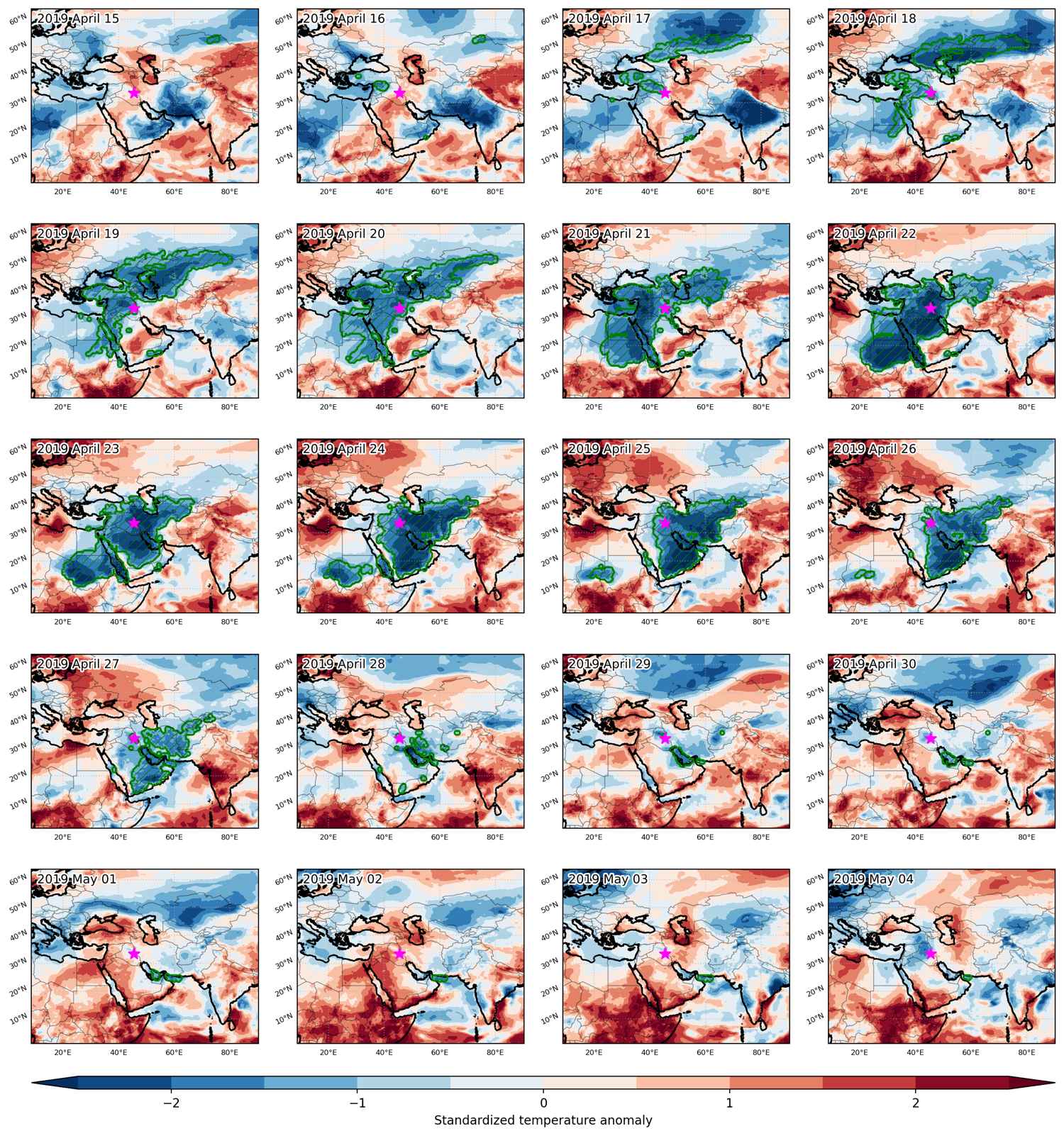


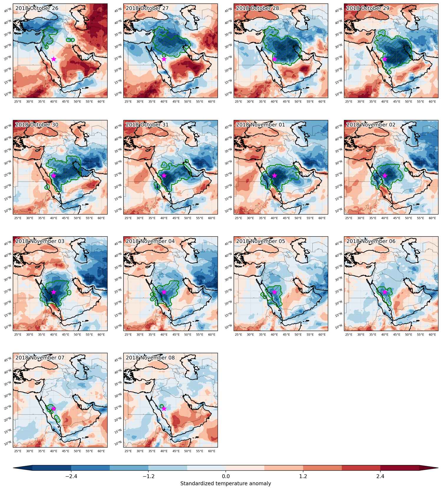
Fig. 3: Maps illustrating the evolution of standardized temperature anomalies during the event.

Event ID: Cold_spell_2019-Apr-15_to_2019-May-04_45.5_33.5
Cold spell occuring from October 26 2018 to November 08 2018 at 24.5°N 40.0°E

Download data: JSON

Event type: Cold spell

Countries affected (identified with ArcGIS Online; provided only for geographical reference):

  • Bahrain
  • Egypt
  • Iran
  • Iraq
  • Jordan
  • Kuwait
  • Saudi Arabia
  • Sudan
  • Syria
  • Turkiye

Duration: 14 days

Time span: October 26 2018 to November 08 2018

Statistics over entire affected area:

  • Mean temperature anomaly: -4.6 °C
  • Mean temperature: 19.2 °C
  • Minimum temperature anomaly: -8.5 °C
  • Minimum temperature: 11.1 °C

Event center: 24.5°N 40.0°E

Area affected: 1884088 km$^2$


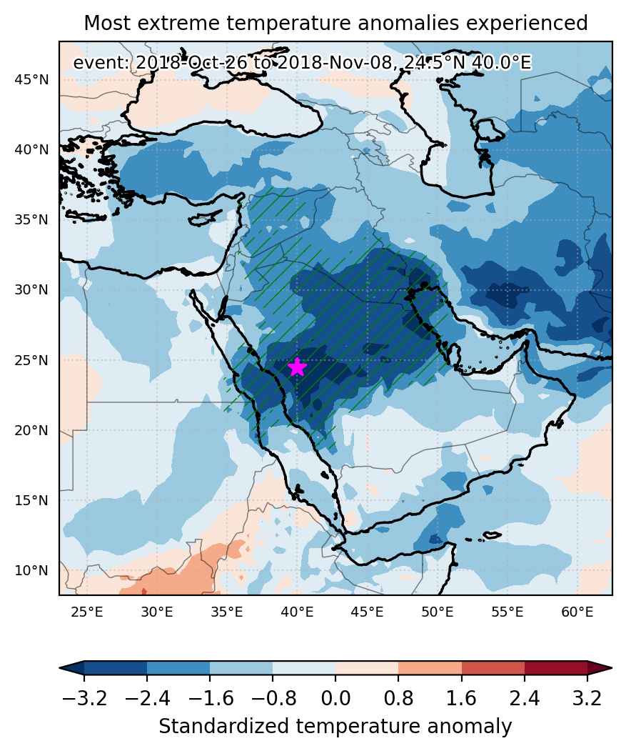
Fig. 1: Map of most extreme temperature anomalies (standardized) experienced during the event. The purple star indicates the center of the extreme event. Green hatching illustrates all areas under the effect of extremes at some time during the event.


Fig. 2: Evolution of temperature at the center of the event. The climatological percentile distribution is illustrated with color shadings.


Fig. 3: Maps illustrating the evolution of standardized temperature anomalies during the event.

Event ID: Cold_spell_2018-Oct-26_to_2018-Nov-08_40.0_24.5

Cold spell occuring from February 13 2017 to February 28 2017 at 38.0°N 45.0°E

Download data: JSON

Event type: Cold spell

Countries affected (identified with ArcGIS Online; provided only for geographical reference):

  • Armenia
  • Azerbaijan
  • Bahrain
  • Cameroon
  • Chad
  • Cyprus
  • Egypt
  • Georgia
  • Iran
  • Iraq
  • Israel
  • Jordan
  • Kuwait
  • Lebanon
  • Libya
  • Niger
  • Nigeria
  • Oman
  • Palestinian Territory
  • Qatar
  • Russian Federation
  • Saudi Arabia
  • Sudan
  • Syria
  • Turkiye
  • United Arab Emirates

Duration: 16 days

Time span: February 13 2017 to February 28 2017

Statistics over entire affected area:

  • Mean temperature anomaly: -5.6 °C
  • Mean temperature: 8.8 °C
  • Minimum temperature anomaly: -17.9 °C
  • Minimum temperature: -21.6 °C

Event center: 38.0°N 45.0°E

Area affected: 6656675 km$^2$


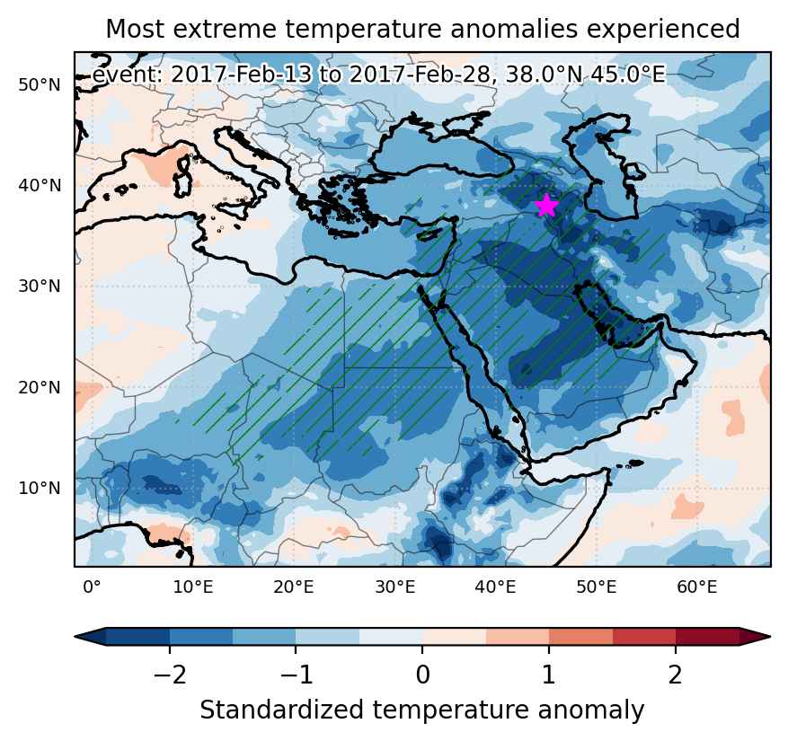
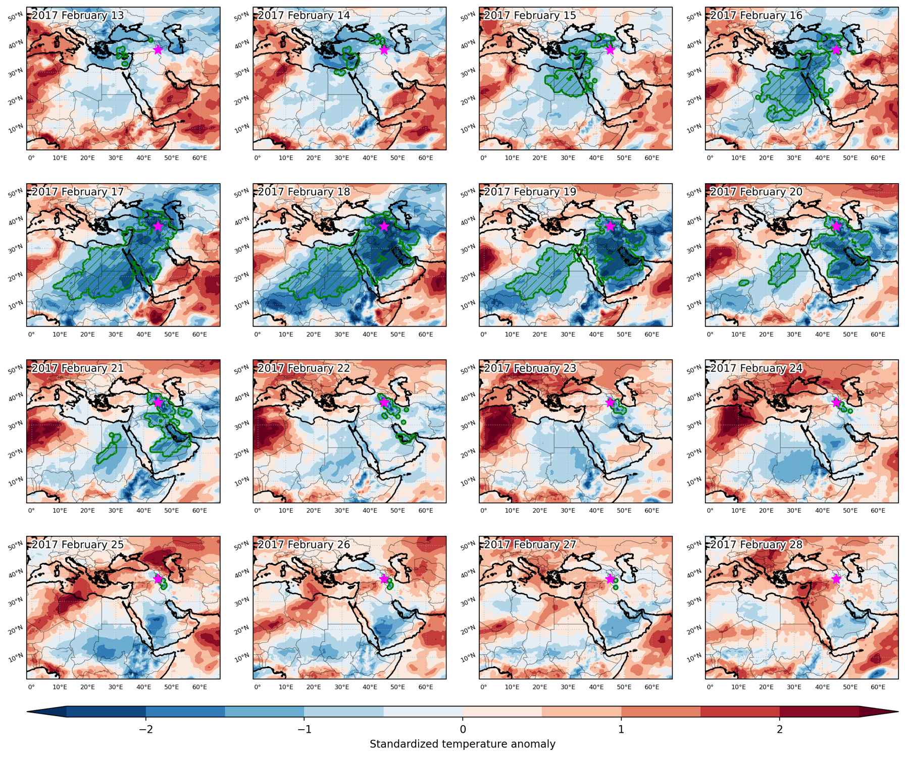
Fig. 1: Map of most extreme temperature anomalies (standardized) experienced during the event. The purple star indicates the center of the extreme event. Green hatching illustrates all areas under the effect of extremes at some time during the event.


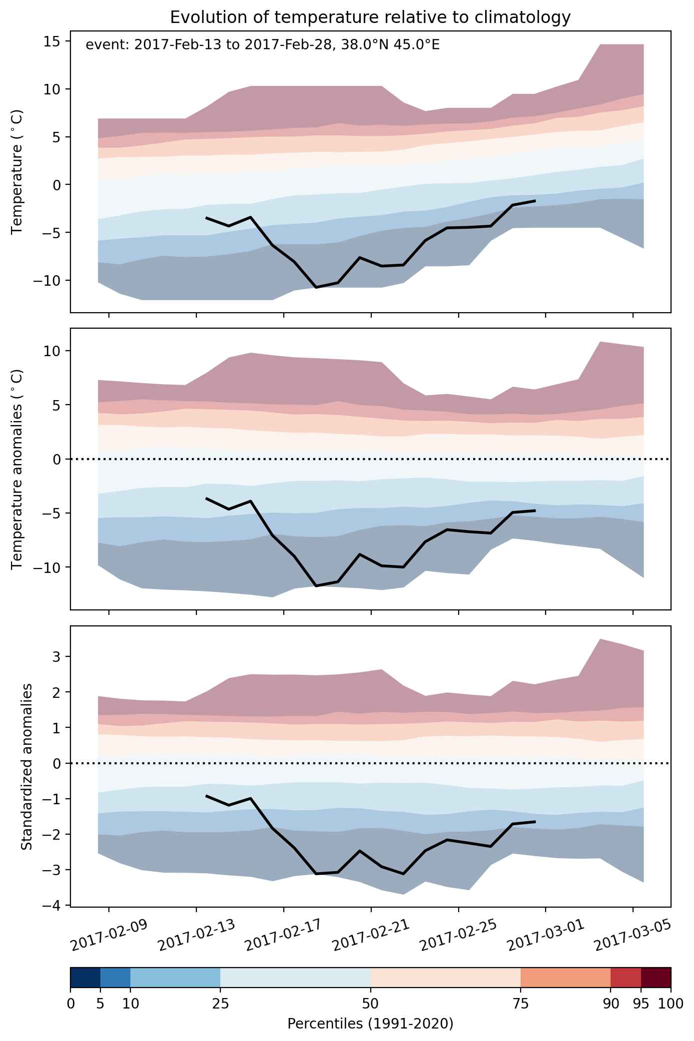
Fig. 2: Evolution of temperature at the center of the event. The climatological percentile distribution is illustrated with color shadings.


Fig. 3: Maps illustrating the evolution of standardized temperature anomalies during the event.

Event ID: Cold_spell_2017-Feb-13_to_2017-Feb-28_45.0_38.0

Cold spell occuring from January 27 2017 to February 08 2017 at 38.0°N 41.0°E

Download data: JSON

Event type: Cold spell

Countries affected (identified with ArcGIS Online; provided only for geographical reference):

  • Armenia
  • Azerbaijan
  • Bahrain
  • Cyprus
  • Iran
  • Iraq
  • Israel
  • Jordan
  • Kuwait
  • Lebanon
  • Oman
  • Pakistan
  • Palestinian Territory
  • Qatar
  • Saudi Arabia
  • Somalia
  • Syria
  • Turkiye
  • United Arab Emirates
  • Yemen

Duration: 13 days

Time span: January 27 2017 to February 08 2017

Statistics over entire affected area:

  • Mean temperature anomaly: -5.5 °C
  • Mean temperature: 9.8 °C
  • Minimum temperature anomaly: -16.8 °C
  • Minimum temperature: -16.6 °C

Event center: 38.0°N 41.0°E

Area affected: 4966195 km$^2$


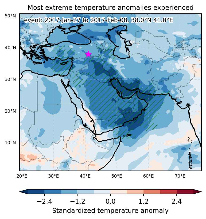
Fig. 1: Map of most extreme temperature anomalies (standardized) experienced during the event. The purple star indicates the center of the extreme event. Green hatching illustrates all areas under the effect of extremes at some time during the event.


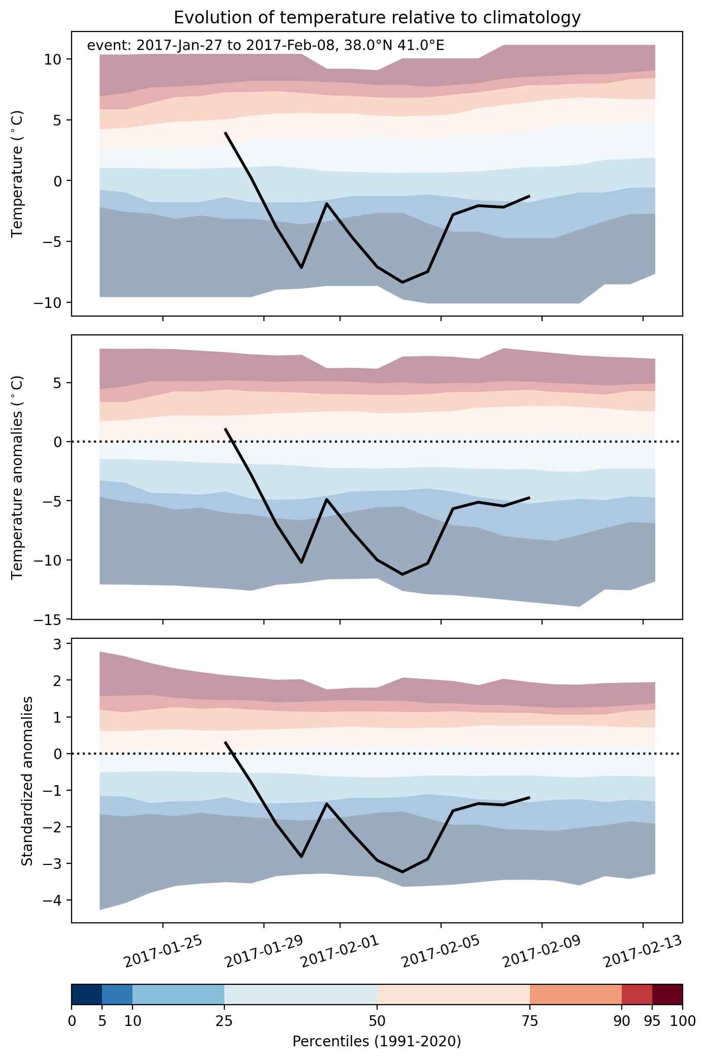
Fig. 2: Evolution of temperature at the center of the event. The climatological percentile distribution is illustrated with color shadings.


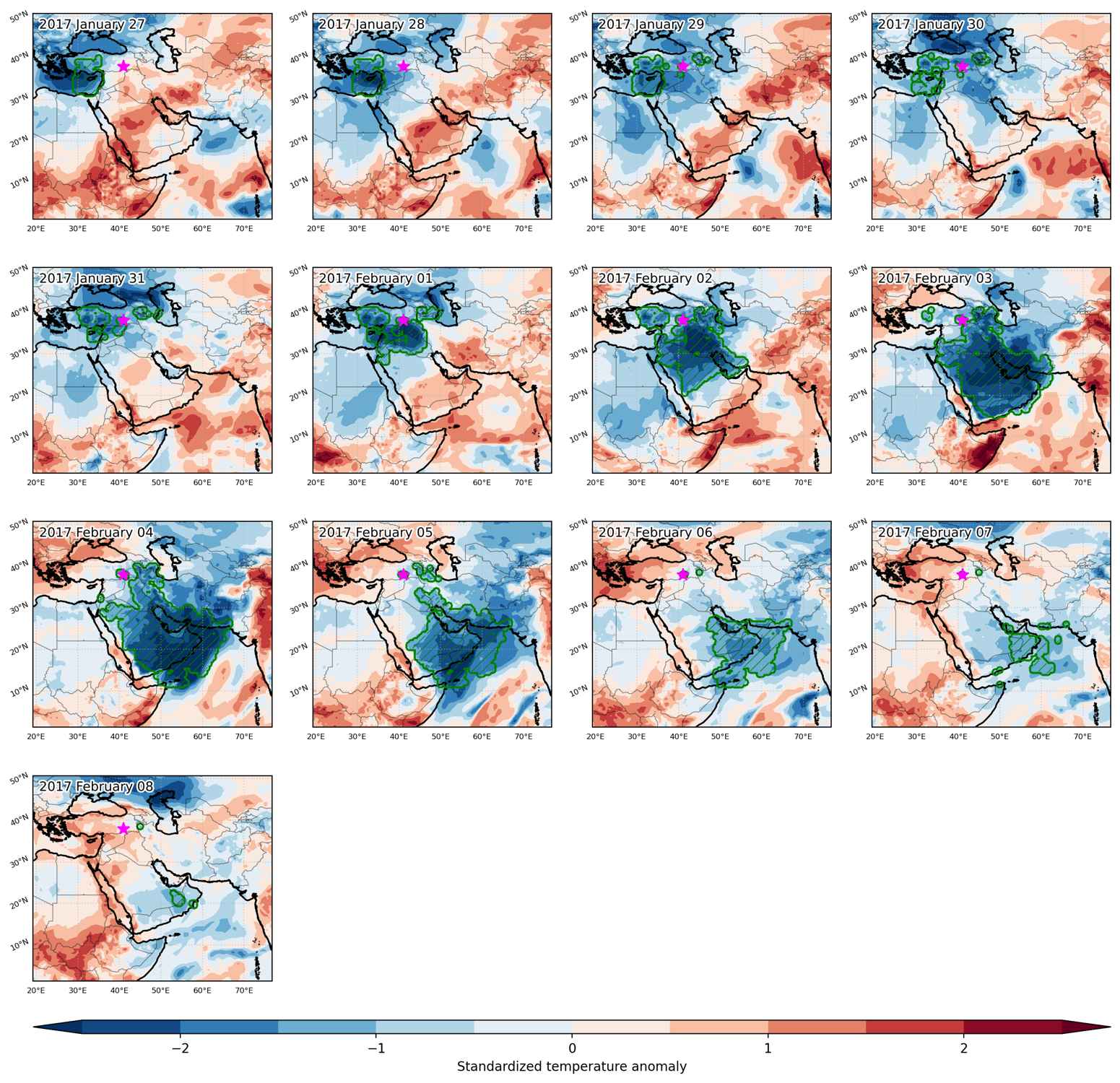
Fig. 3: Maps illustrating the evolution of standardized temperature anomalies during the event.

Event ID: Cold_spell_2017-Jan-27_to_2017-Feb-08_41.0_38.0

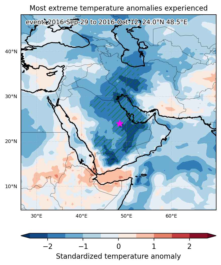
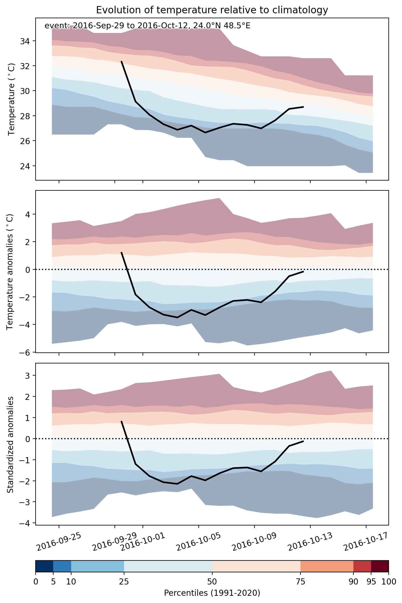
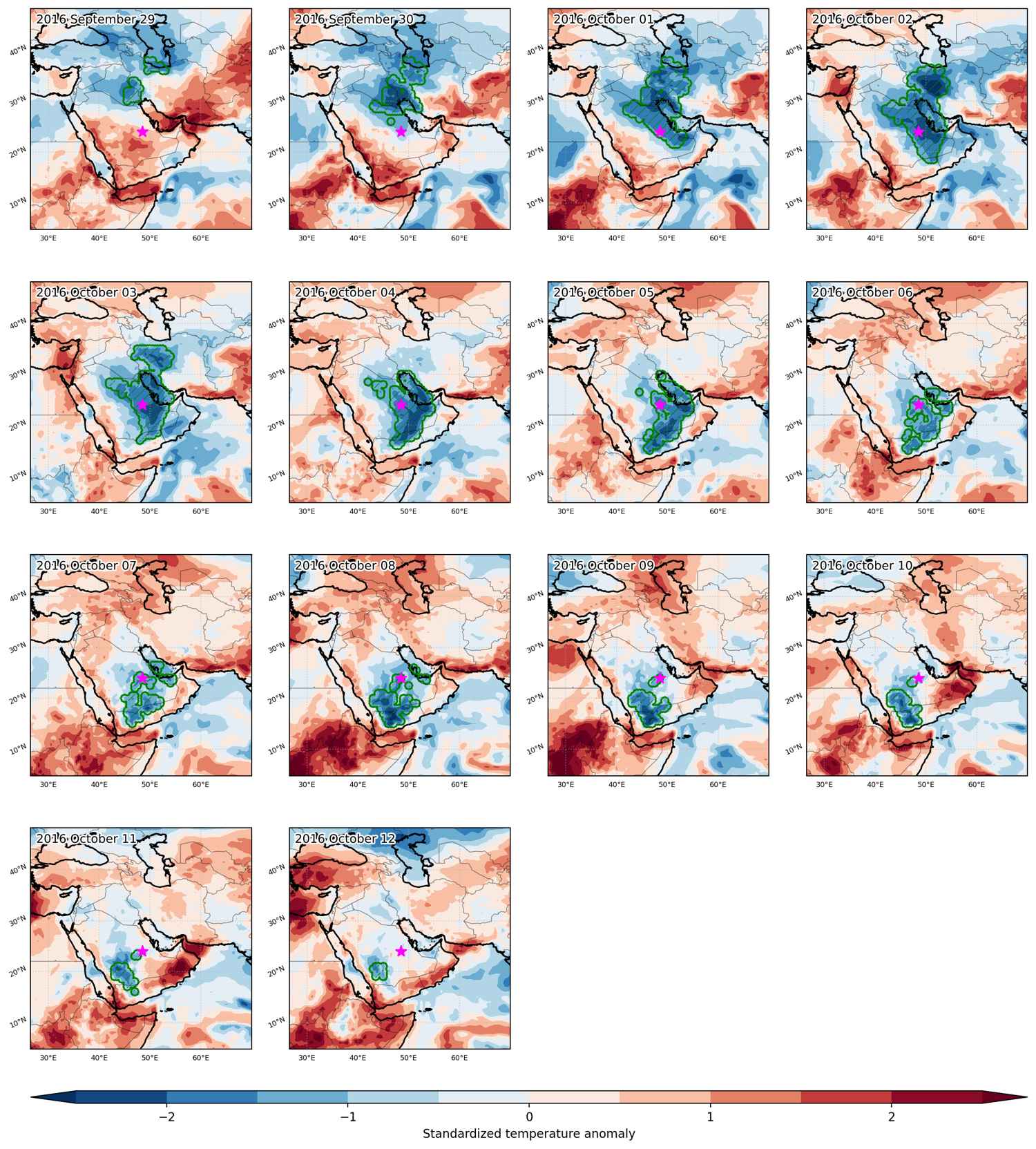
Cold spell occuring from September 29 2016 to October 12 2016 at 24.0°N 48.5°E

Download data: JSON

Event type: Cold spell

Countries affected (identified with ArcGIS Online; provided only for geographical reference):

  • Bahrain
  • Iran
  • Iraq
  • Kuwait
  • Oman
  • Qatar
  • Saudi Arabia
  • United Arab Emirates
  • Yemen

Duration: 14 days

Time span: September 29 2016 to October 12 2016

Statistics over entire affected area:

  • Mean temperature anomaly: -2.9 °C
  • Mean temperature: 25.4 °C
  • Minimum temperature anomaly: -9.2 °C
  • Minimum temperature: 5.8 °C

Event center: 24.0°N 48.5°E

Area affected: 1490790 km$^2$


Fig. 1: Map of most extreme temperature anomalies (standardized) experienced during the event. The purple star indicates the center of the extreme event. Green hatching illustrates all areas under the effect of extremes at some time during the event.


Fig. 2: Evolution of temperature at the center of the event. The climatological percentile distribution is illustrated with color shadings.


Fig. 3: Maps illustrating the evolution of standardized temperature anomalies during the event.

Event ID: Cold_spell_2016-Sep-29_to_2016-Oct-12_48.5_24.0

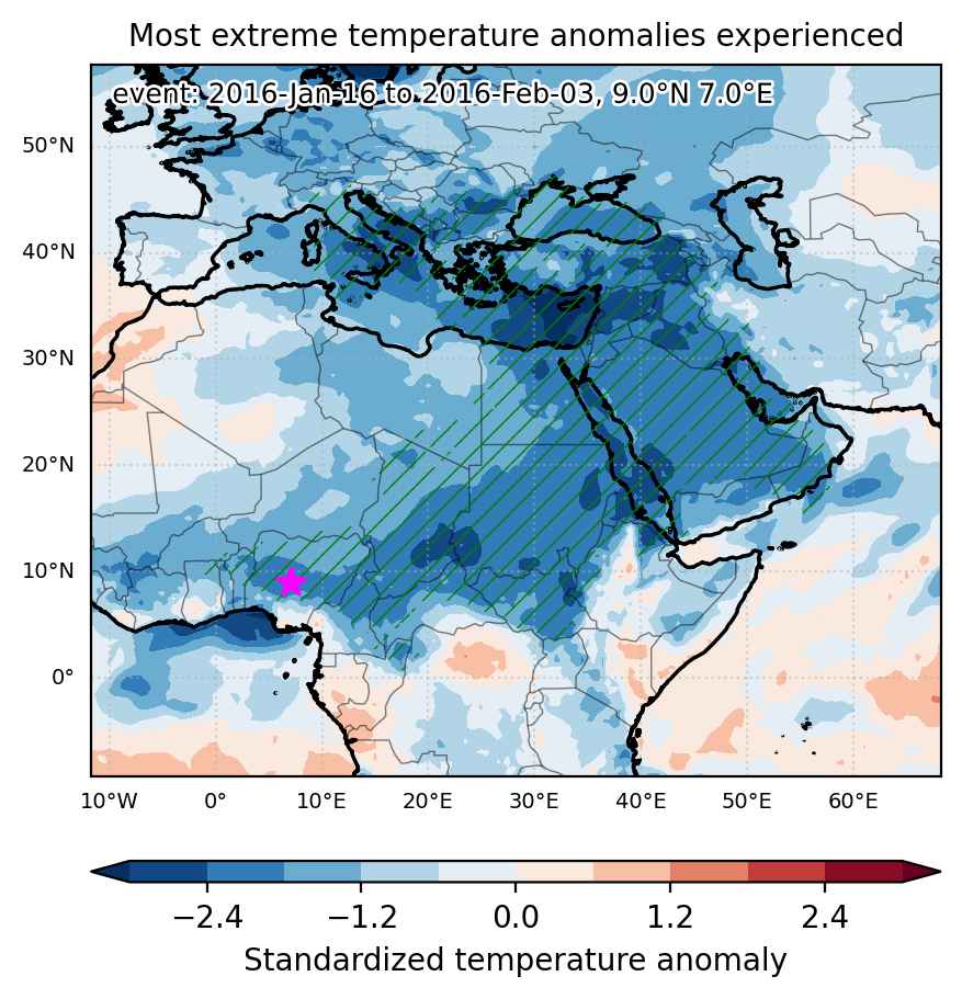
Cold spell occuring from January 16 2016 to February 03 2016 at 9.0°N 7.0°E

Download data: JSON

Event type: Cold spell

Countries affected (identified with ArcGIS Online; provided only for geographical reference):

  • Albania
  • Armenia
  • Austria
  • Azerbaijan
  • Bahrain
  • Benin
  • Bosnia and Herzegovina
  • Bulgaria
  • Burkina Faso
  • Cameroon
  • Central African Republic
  • Chad
  • Congo
  • Congo DRC
  • Croatia
  • Cyprus
  • Egypt
  • Eritrea
  • Ethiopia
  • Georgia
  • Ghana
  • Greece
  • Iran
  • Iraq
  • Israel
  • Italy
  • Jordan
  • Kuwait
  • Lebanon
  • Libya
  • Moldova
  • Montenegro
  • Niger
  • Nigeria
  • North Macedonia
  • Oman
  • Palestinian Territory
  • Qatar
  • Romania
  • Russian Federation
  • Saudi Arabia
  • Serbia
  • Slovenia
  • South Sudan
  • Sudan
  • Syria
  • Togo
  • Turkiye
  • Uganda
  • Ukraine
  • United Arab Emirates
  • Yemen

Duration: 19 days

Time span: January 16 2016 to February 03 2016

Statistics over entire affected area:

  • Mean temperature anomaly: -5.3 °C
  • Mean temperature: 11.7 °C
  • Minimum temperature anomaly: -15.9 °C
  • Minimum temperature: -23.6 °C

Event center: 9.0°N 7.0°E

Area affected: 13484905 km$^2$


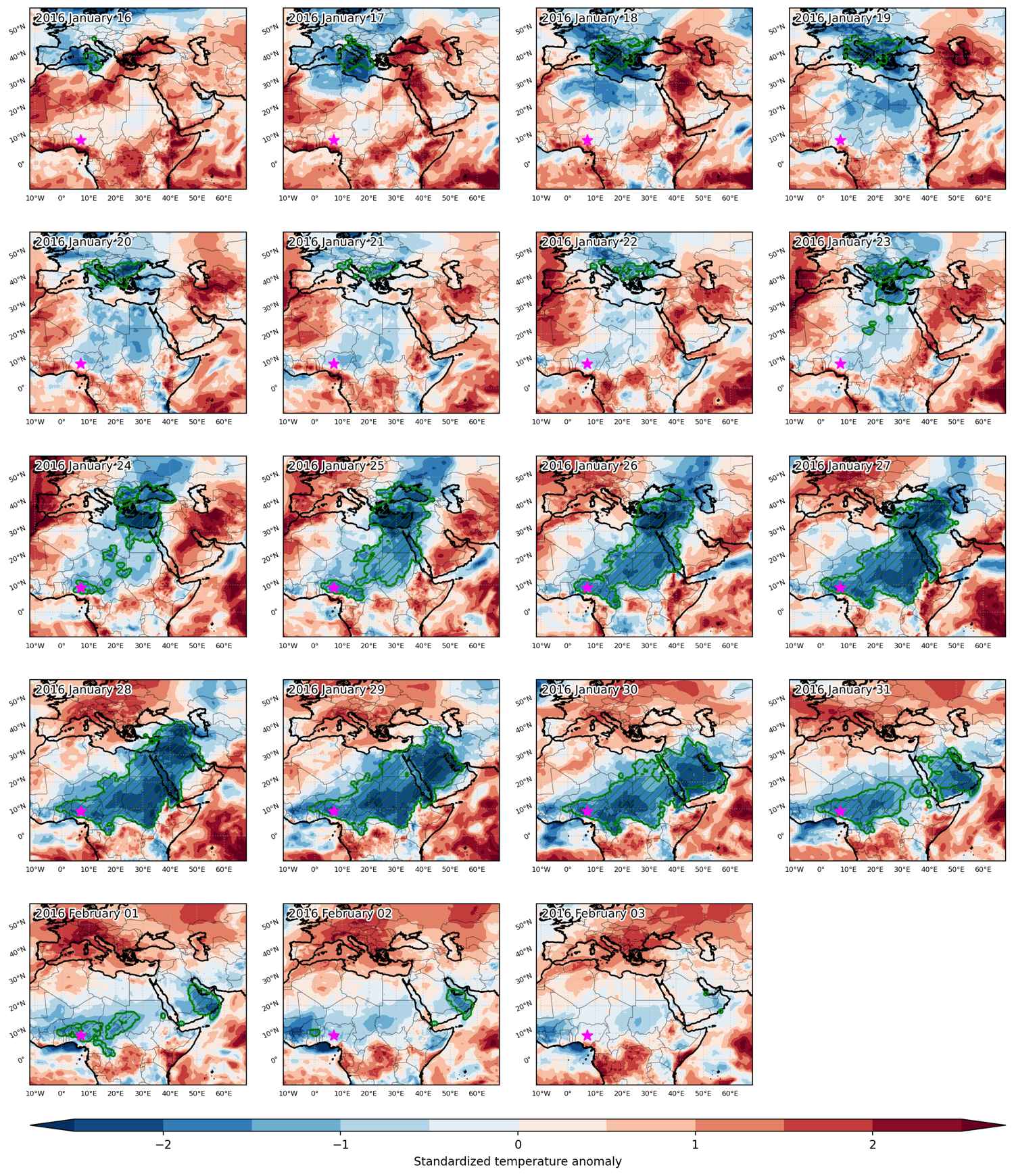
Fig. 1: Map of most extreme temperature anomalies (standardized) experienced during the event. The purple star indicates the center of the extreme event. Green hatching illustrates all areas under the effect of extremes at some time during the event.


Fig. 2: Evolution of temperature at the center of the event. The climatological percentile distribution is illustrated with color shadings.


Fig. 3: Maps illustrating the evolution of standardized temperature anomalies during the event.

Event ID: Cold_spell_2016-Jan-16_to_2016-Feb-03_7.0_9.0

Cold spell occuring from December 03 2015 to December 26 2015 at 35.0°N 49.5°E

Download data: JSON

Event type: Cold spell

Countries affected (identified with ArcGIS Online; provided only for geographical reference):

  • Afghanistan
  • Armenia
  • Azerbaijan
  • Bahrain
  • China
  • Egypt
  • India
  • Iran
  • Iraq
  • Israel
  • Jordan
  • Kazakhstan
  • Kuwait
  • Kyrgyzstan
  • Lebanon
  • Oman
  • Pakistan
  • Palestinian Territory
  • Qatar
  • Saudi Arabia
  • Syria
  • Tajikistan
  • Turkiye
  • Turkmenistan
  • Uzbekistan
  • Yemen

Duration: 24 days

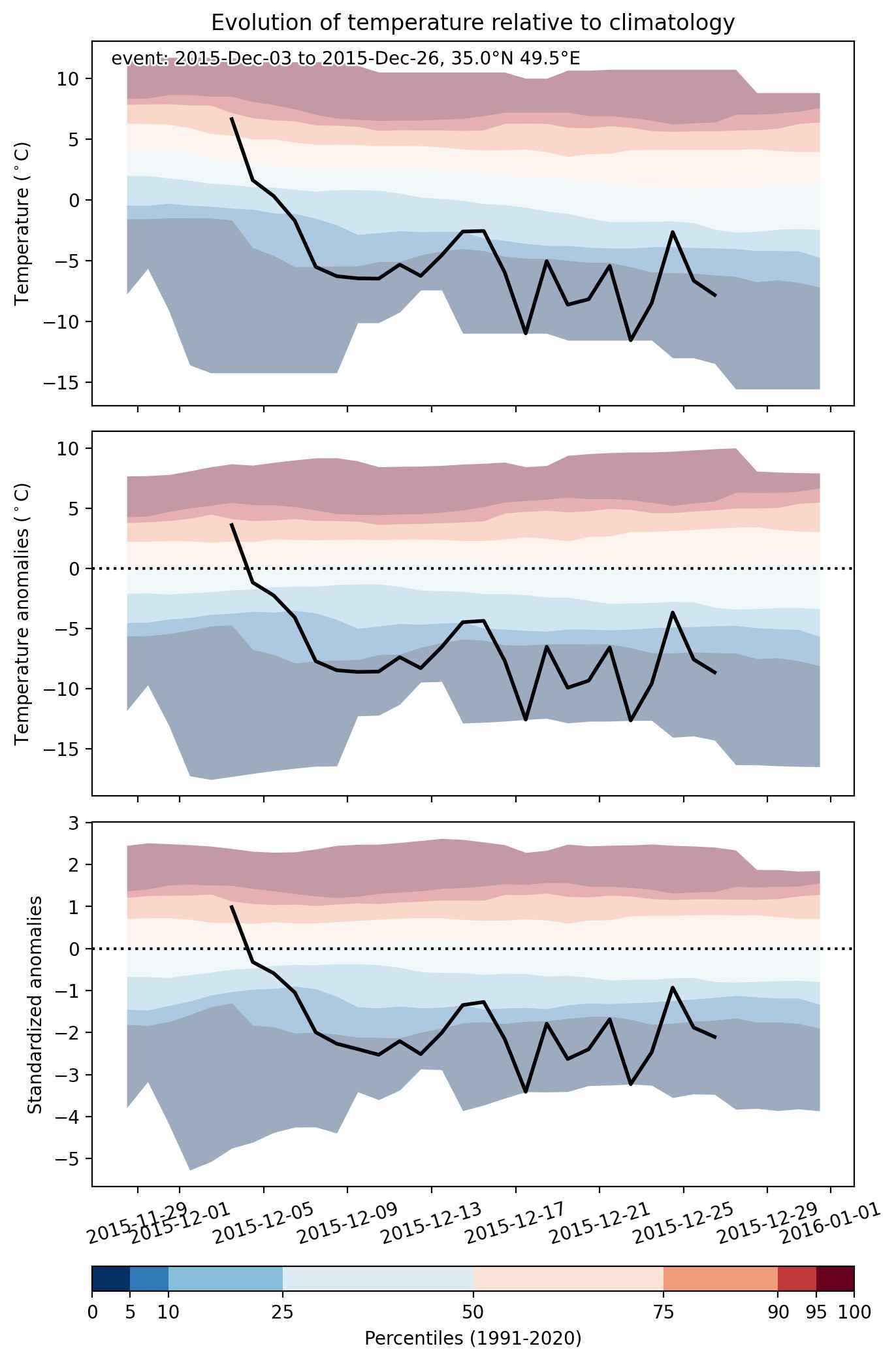
Time span: December 03 2015 to December 26 2015

Statistics over entire affected area:

  • Mean temperature anomaly: -5.5 °C
  • Mean temperature: 1.6 °C
  • Minimum temperature anomaly: -14.9 °C
  • Minimum temperature: -38.5 °C

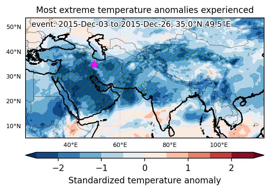
Event center: 35.0°N 49.5°E

Area affected: 7260111 km$^2$


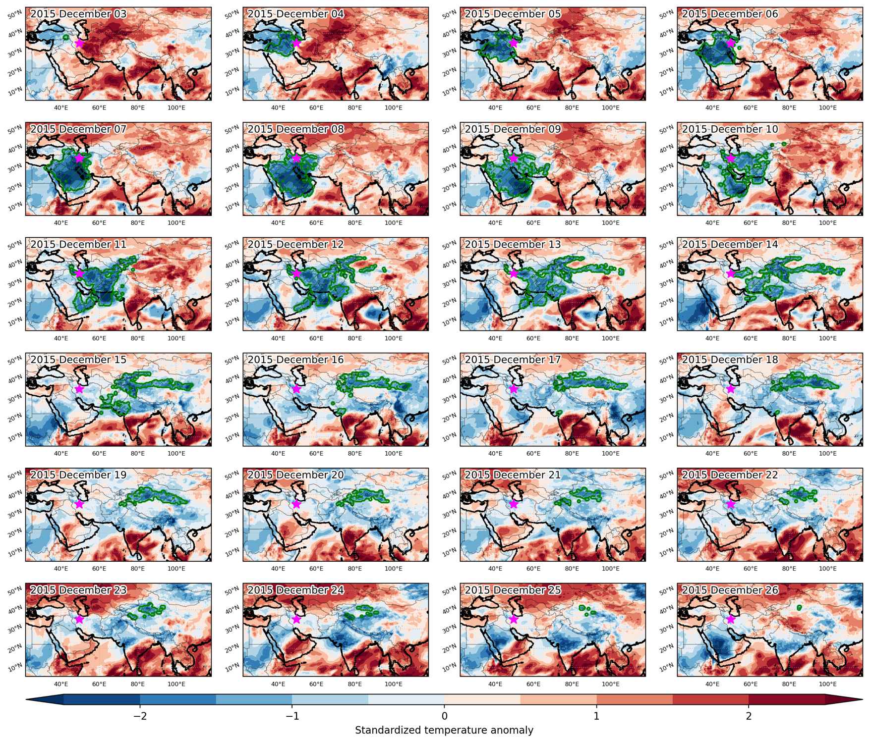
Fig. 1: Map of most extreme temperature anomalies (standardized) experienced during the event. The purple star indicates the center of the extreme event. Green hatching illustrates all areas under the effect of extremes at some time during the event.


Fig. 2: Evolution of temperature at the center of the event. The climatological percentile distribution is illustrated with color shadings.


Fig. 3: Maps illustrating the evolution of standardized temperature anomalies during the event.

Event ID: Cold_spell_2015-Dec-03_to_2015-Dec-26_49.5_35.0

Cold spell occuring from February 18 2015 to March 11 2015 at 18.0°N 74.5°E

Download data: JSON

Event type: Cold spell

Countries affected (identified with ArcGIS Online; provided only for geographical reference):

  • Afghanistan
  • Bahrain
  • Cyprus
  • Egypt
  • India
  • Iran
  • Iraq
  • Israel
  • Jordan
  • Kuwait
  • Lebanon
  • Nepal
  • Oman
  • Pakistan
  • Palestinian Territory
  • Qatar
  • Saudi Arabia
  • Syria
  • Turkiye
  • Turkmenistan
  • United Arab Emirates
  • Yemen

Duration: 22 days

Time span: February 18 2015 to March 11 2015

Statistics over entire affected area:

  • Mean temperature anomaly: -4.5 °C
  • Mean temperature: 15.1 °C
  • Minimum temperature anomaly: -13.8 °C
  • Minimum temperature: -15.2 °C

Event center: 18.0°N 74.5°E

Area affected: 6870304 km$^2$


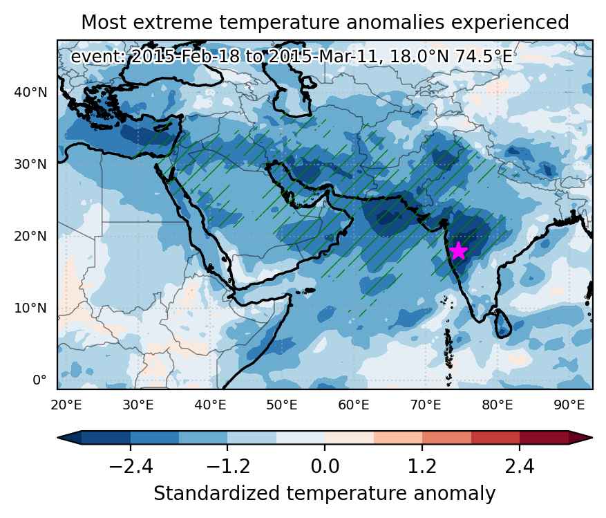
Fig. 1: Map of most extreme temperature anomalies (standardized) experienced during the event. The purple star indicates the center of the extreme event. Green hatching illustrates all areas under the effect of extremes at some time during the event.


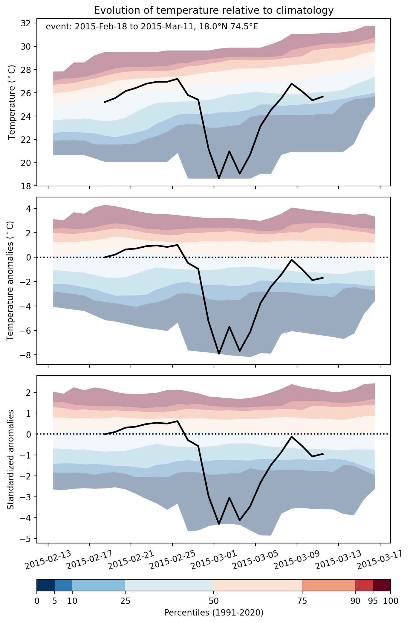
Fig. 2: Evolution of temperature at the center of the event. The climatological percentile distribution is illustrated with color shadings.


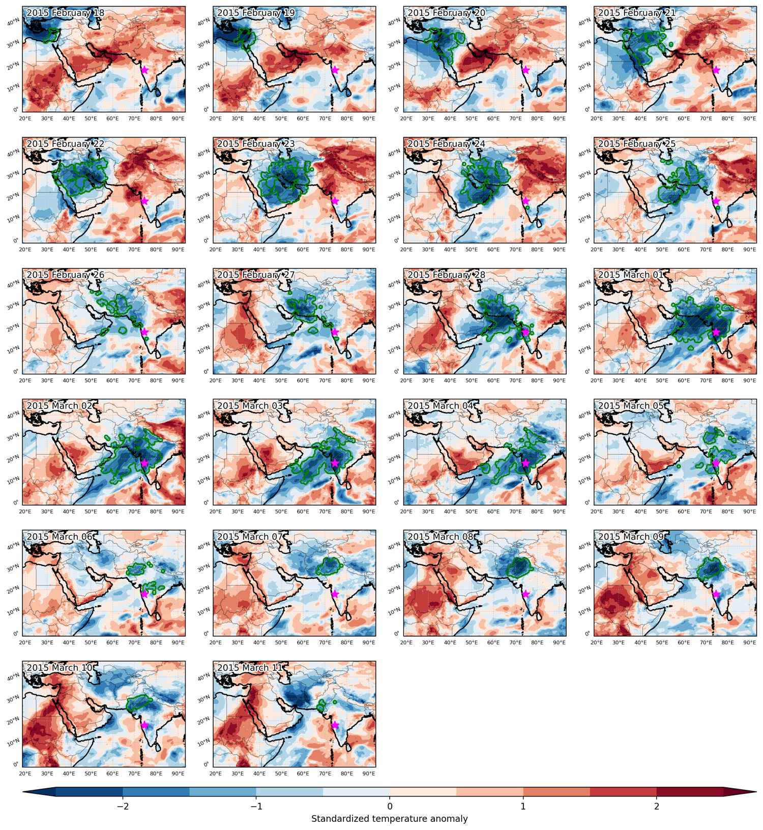
Fig. 3: Maps illustrating the evolution of standardized temperature anomalies during the event.

Event ID: Cold_spell_2015-Feb-18_to_2015-Mar-11_74.5_18.0

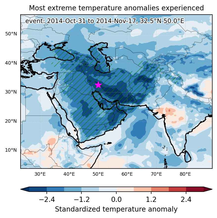
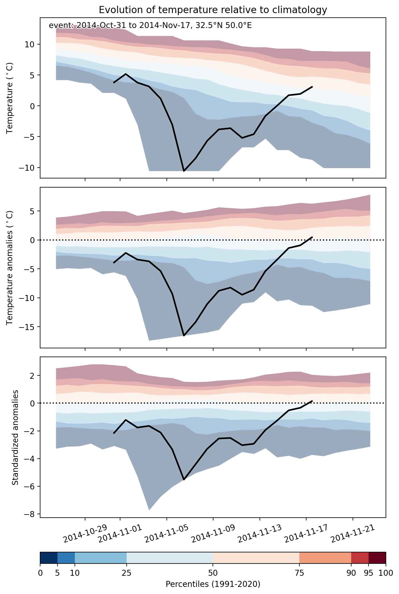
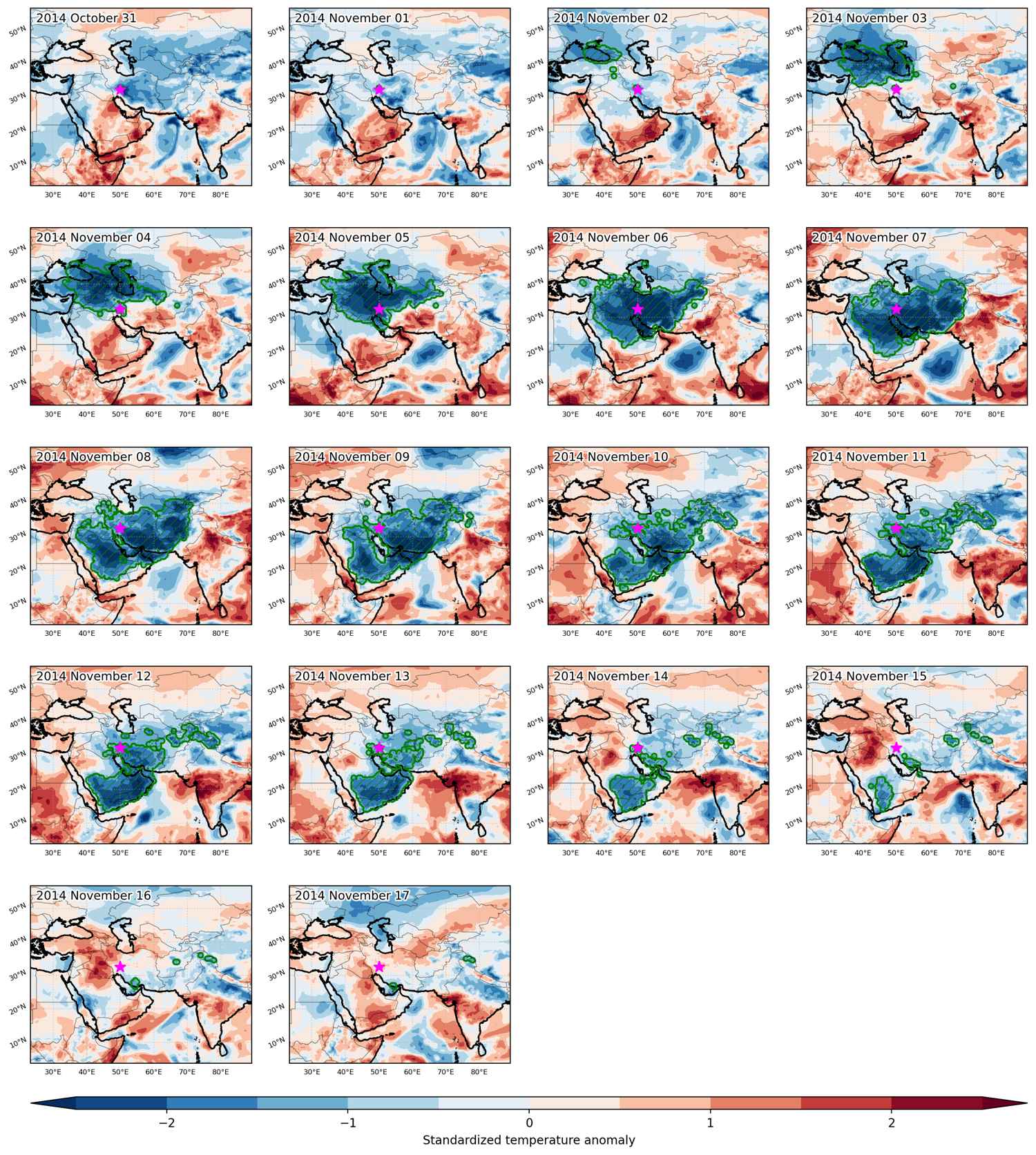
Cold spell occuring from October 31 2014 to November 17 2014 at 32.5°N 50.0°E

Download data: JSON

Event type: Cold spell

Countries affected (identified with ArcGIS Online; provided only for geographical reference):

  • Afghanistan
  • Armenia
  • Azerbaijan
  • Bahrain
  • China
  • Georgia
  • India
  • Iran
  • Iraq
  • Jordan
  • Kuwait
  • Kyrgyzstan
  • Oman
  • Pakistan
  • Qatar
  • Russian Federation
  • Saudi Arabia
  • Syria
  • Tajikistan
  • Turkiye
  • Turkmenistan
  • United Arab Emirates
  • Uzbekistan
  • Yemen

Duration: 18 days

Time span: October 31 2014 to November 17 2014

Statistics over entire affected area:

  • Mean temperature anomaly: -5.3 °C
  • Mean temperature: 10.9 °C
  • Minimum temperature anomaly: -18.8 °C
  • Minimum temperature: -30.9 °C

Event center: 32.5°N 50.0°E

Area affected: 6975145 km$^2$


Fig. 1: Map of most extreme temperature anomalies (standardized) experienced during the event. The purple star indicates the center of the extreme event. Green hatching illustrates all areas under the effect of extremes at some time during the event.


Fig. 2: Evolution of temperature at the center of the event. The climatological percentile distribution is illustrated with color shadings.


Fig. 3: Maps illustrating the evolution of standardized temperature anomalies during the event.

Event ID: Cold_spell_2014-Oct-31_to_2014-Nov-17_50.0_32.5

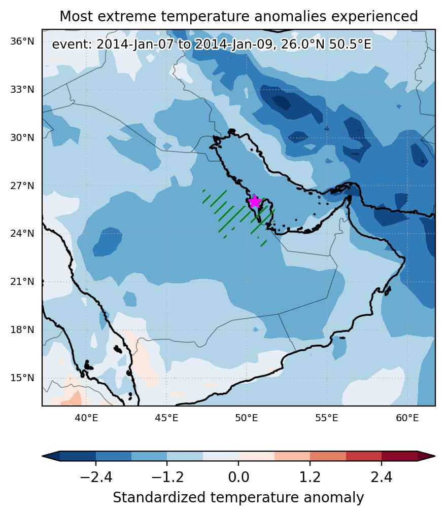
Cold spell occuring from January 07 2014 to January 09 2014 at 26.0°N 50.5°E

Download data: JSON

Event type: Cold spell

Countries affected (identified with ArcGIS Online; provided only for geographical reference):

  • Bahrain
  • Qatar
  • Saudi Arabia

Duration: 3 days

Time span: January 07 2014 to January 09 2014

Statistics over entire affected area:

  • Mean temperature anomaly: -4.4 °C
  • Mean temperature: 11.1 °C
  • Minimum temperature anomaly: -5.6 °C
  • Minimum temperature: 8.6 °C

Event center: 26.0°N 50.5°E

Area affected: 78297 km$^2$


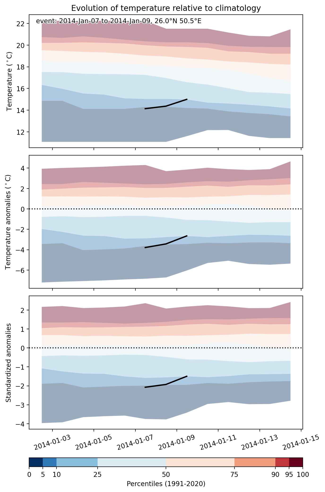
Fig. 1: Map of most extreme temperature anomalies (standardized) experienced during the event. The purple star indicates the center of the extreme event. Green hatching illustrates all areas under the effect of extremes at some time during the event.


Fig. 2: Evolution of temperature at the center of the event. The climatological percentile distribution is illustrated with color shadings.


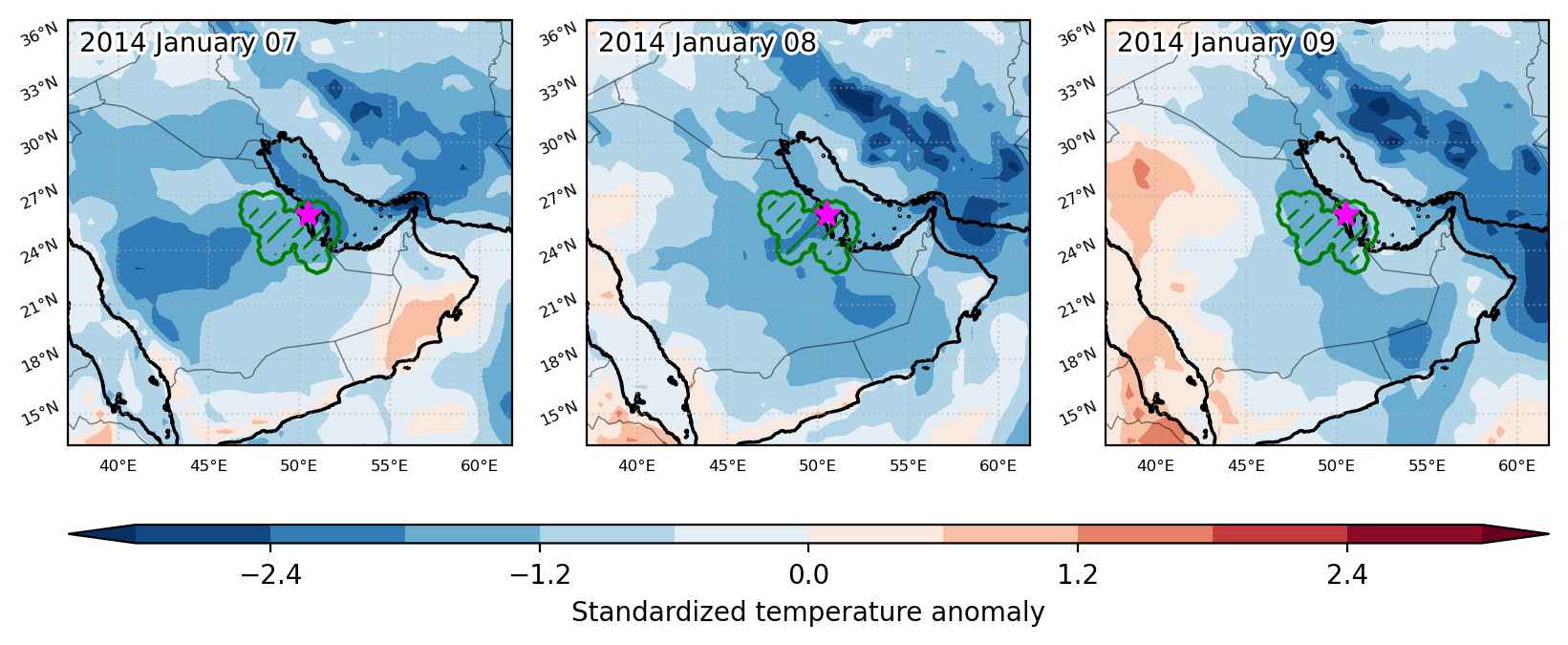
Fig. 3: Maps illustrating the evolution of standardized temperature anomalies during the event.

Event ID: Cold_spell_2014-Jan-07_to_2014-Jan-09_50.5_26.0